Select location of well to view details.
Click on column heading to sort.
|
|
|
County: Meade Select location of well to view details. Click on column heading to sort. |
|
|
|
| View page: < Prev || 31 || 32 || 33 || 34 || 35 || 36 || 37 || 38 || 39 || 40 || Next > | |||||||||
| T-R-S | Owner | Well Depth Ascend. Desc. |
Static Water Level Ascend. Desc. |
Est. Yield Ascend. Desc. |
Well Use | Other ID | Action Taken | Completion Date Ascend. Desc. |
Scan? |
|
T33S, R30W, Sec. 7 NW NW SE |
Feiertag, Erwin | 340 ft. | Oil Field Water Supply | Plugged | 30-Jun-1994 | ||||
|
T33S, R30W, Sec. 8 NW NE NW |
Bender, Holmes Carol | 494 ft. | 184 ft. | 2700 gpm. | Irrigation | Constructed | 17-Apr-1976 | ||
|
T33S, R30W, Sec. 8 SE SE NW |
High Plains Ponderosa Dairy | 595 ft. | 290 ft. | 1475 gpm. | Irrigation | Constructed | 09-Aug-2023 |
KOLAR |
|
|
T33S, R30W, Sec. 8 SE SE NW |
High Plains Ponderosa Dairy | 595 ft. | 290 ft. | 1400 gpm. | Irrigation | Constructed | 09-Aug-2023 |
KOLAR |
|
|
T33S, R30W, Sec. 8 SW SW SE |
Hush, Jim | 506 ft. | 267 ft. | 50 gpm. | Domestic, Livestock | Constructed | 11-Aug-2015 | ||
|
T33S, R30W, Sec. 9 SW SE NW |
Jennings, Arlene | 340 ft. | 189 ft. | Oil Field Water Supply | Jennings 9-2 | Plugged | 22-Jun-1985 | ||
|
T33S, R30W, Sec. 9 SW SE NW |
Jennings, Arlene | 340 ft. | 189 ft. | 75 gpm. | Oil Field Water Supply | Jennings 9-2 | Constructed | 22-Jun-1985 | |
|
T33S, R30W, Sec. 9 SE SW SE |
Murfin Drilling | 290 ft. | 195 ft. | 60 gpm. | Oil Field Water Supply | Constructed | 26-Feb-1985 | ||
|
T33S, R30W, Sec. 10 SW SE SW |
Holmes, HA | 360 ft. | 185 ft. | 60 gpm. | Oil Field Water Supply | Holmes 24-10 | Constructed | 17-Nov-1981 | |
|
T33S, R30W, Sec. 12 NE NW NW NW |
Clawson Land Partnership | 531 ft. | 239 ft. | 1547 gpm. | Irrigation | Constructed | 17-May-2017 |
KOLAR |
|
|
T33S, R30W, Sec. 12 NE SE SE |
Fink, Vida | 324 ft. | 168 ft. | 75 gpm. | Domestic | Constructed | 02-Oct-1981 | ||
|
T33S, R30W, Sec. 12 SE SE SE |
Winfrey, Larry | 465 ft. | 204 ft. | Irrigation | Test 1 | Constructed | 04-Nov-1994 | ||
|
T33S, R30W, Sec. 13 SW NW NW NE |
Bromwell, Mannley | 490 ft. | 244 ft. | 1247 gpm. | Irrigation | Constructed | 16-Sep-2014 |
KOLAR |
|
|
T33S, R30W, Sec. 13 E2 NW NE |
McCoy Pet | 320 ft. | 200 ft. | 110 gpm. | Oil Field Water Supply | Bromwell A 1-13 | Constructed | 15-Apr-1996 | |
|
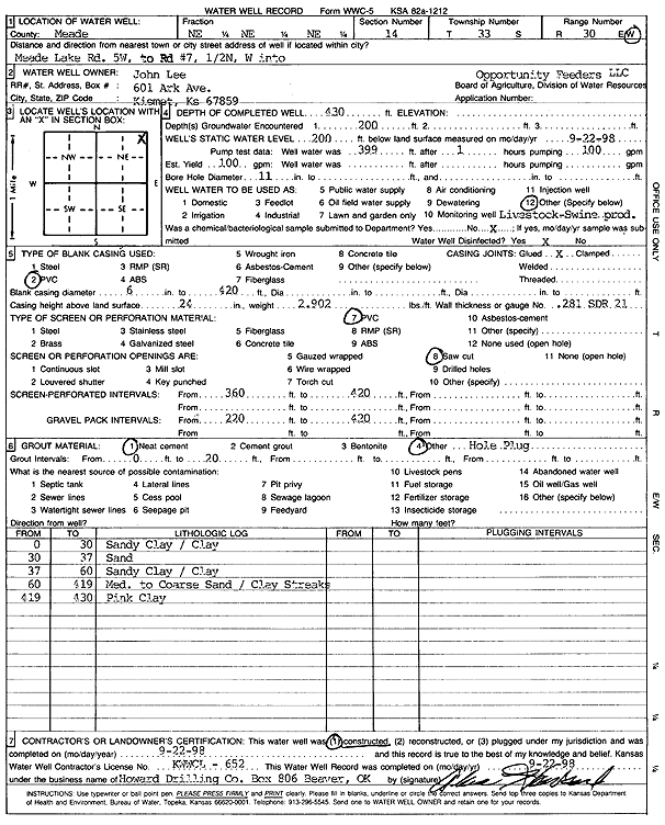
T33S, R30W, Sec. 14 NE NE NE |
Lee, John | 430 ft. | 200 ft. | 100 gpm. | Feedlot | Constructed | 22-Sep-1998 | Scan | |
|
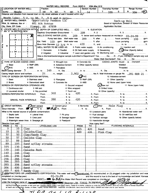
T33S, R30W, Sec. 14 NE NE NE |
Opportunity Feeders LLC | 420 ft. | 209 ft. | 100 gpm. | Feedlot | Constructed | 24-Mar-1999 | Scan | |
|
T33S, R30W, Sec. 15 C NW NW |
Cities Service | 360 ft. | Oil Field Water Supply | Armen Trout B 2 | Plugged | 28-Oct-1981 | |||
|
T33S, R30W, Sec. 15 C NW NW |
Cities Service | 360 ft. | 190 ft. | 50 gpm. | Oil Field Water Supply | Armen Trout B 2 | Constructed | 01-Oct-1981 | |
|
T33S, R30W, Sec. 15 SE NE SW NE |
Hamm, Terry and Mike | 583 ft. | 274 ft. | 1106 gpm. | Irrigation | Constructed | 14-Nov-2019 |
KOLAR |
|
|
T33S, R30W, Sec. 16 NW NW SW |
Fox, Delbert | 360 ft. | 240 ft. | 50 gpm. | Domestic | Constructed | 22-Aug-2003 | ||
|
T33S, R30W, Sec. 17 W2 SW SW |
Pickrell Drilling Co. | 280 ft. | 185 ft. | Oil Field Water Supply | Constructed | 12-Feb-1980 | |||
|
T33S, R30W, Sec. 17 NE NE NE |
SW Windmill | 480 ft. | 240 ft. | Domestic | Constructed | 15-Mar-2005 | |||
|
T33S, R30W, Sec. 18 NW SW NW |
Hayden, Jerry | 340 ft. | 205 ft. | 50 gpm. | Domestic | Constructed | 31-Aug-1989 | ||
|
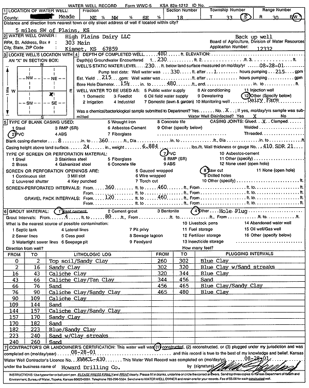
T33S, R30W, Sec. 18 NE NW SE |
High Plains Dairy LLC | 480 ft. | 230 ft. | Feedlot | Constructed | 28-Aug-2001 | Scan | ||
|
T33S, R30W, Sec. 18 NW SW NW |
Hush, Jim | 190 ft. | 190 ft. | Domestic | Plugged | 31-Aug-1990 | |||
|
T33S, R30W, Sec. 18 NW SW NW |
Hush, Jim | 370 ft. | 228 ft. | 20 gpm. | Domestic | Constructed | 29-Aug-1990 | ||
|
T33S, R30W, Sec. 18 C W2 NE |
Search Drilling Co. | 360 ft. | 200 ft. | 120 gpm. | Oil Field Water Supply | Constructed | 05-Dec-1978 | ||
|
T33S, R30W, Sec. 19 C NE NE |
Da Mac Drilling | 312 ft. | 168 ft. | 50 gpm. | Oil Field Water Supply | Constructed | 18-Nov-1977 | ||
|
T33S, R30W, Sec. 19 SE SE SE |
High Plains Ponderosa Dairy LLC | 520 ft. | 276 ft. | 50 gpm. | Domestic | Constructed | 01-Nov-2017 | ||
|
T33S, R30W, Sec. 19 SW SW SW |
Newman and Wheatley Farms Inc | 543 ft. | 204 ft. | 1550 gpm. | Irrigation | Constructed | 25-Nov-1997 | ||
|
T33S, R30W, Sec. 19 C SW |
Newman and Wheatley Farms Inc | 280 ft. | 183 ft. | 60 gpm. | Oil Field Water Supply | Neumann 1 | Constructed | 24-Jul-1984 | |
|
T33S, R30W, Sec. 19 C |
Ormiston, Rock | 478 ft. | 203 ft. | 512 gpm. | Irrigation | Constructed | 03-Dec-1997 | ||
|
T33S, R30W, Sec. 20 SW NE NE |
Cities Service | 320 ft. | 167 ft. | 60 gpm. | Oil Field Water Supply | Meyer E 2 | Plugged | 02-Mar-1984 | |
|
T33S, R30W, Sec. 20 SW NE NE |
Cities Service | 320 ft. | 167 ft. | 60 gpm. | Oil Field Water Supply | Meyer E 2 | Constructed | 02-Aug-1983 | |
|
T33S, R30W, Sec. 20 SW SW SE |
Fulton, Mike | 400 ft. | 220 ft. | Domestic | Constructed | 17-Aug-1999 | Scan | ||
|
T33S, R30W, Sec. 21 SW SW NE |
McVey, V V | 453 ft. | 183 ft. | 3000 gpm. | Irrigation | Constructed | 11-Mar-1976 | ||
|
T33S, R30W, Sec. 21 SW SW SE |
McVey, V V | 480 ft. | 178 ft. | 3100 gpm. | Irrigation | Constructed | 09-Oct-1976 | ||
|
T33S, R30W, Sec. 22 C SE NE |
Powell Farms | 424 ft. | 204 ft. | Irrigation | Plugged | 13-Mar-2008 | |||
|
T33S, R30W, Sec. 22 SE SE NE |
Powell Farms | 561 ft. | 223 ft. | Irrigation | Constructed | 16-Nov-2007 | |||
|
T33S, R30W, Sec. 22 NE NE NE |
Powell, Don | 333 ft. | 175 ft. | 28 gpm. | Domestic | Constructed | 28-Oct-1975 | ||
|
T33S, R30W, Sec. 22 SE SE NE |
Powell, Don | 422 ft. | 174 ft. | 2000 gpm. | Irrigation | Constructed | 14-May-1976 | ||
|
T33S, R30W, Sec. 23 NE SW NW |
Cities Service | 320 ft. | 197 ft. | 75 gpm. | Oil Field Water Supply | Novenger 206 | Plugged | 15-Jan-1985 | |
|
T33S, R30W, Sec. 23 NE SW NW |
Cities Service | 320 ft. | 197 ft. | 75 gpm. | Oil Field Water Supply | Novenger 206 | Constructed | 11-Dec-1984 | |
|
T33S, R30W, Sec. 23 C NW NW |
Cities Service | 340 ft. | 187 ft. | 60 gpm. | Oil Field Water Supply | Langlofer M 1 | Constructed | 03-Jun-1982 | |
|
T33S, R30W, Sec. 23 SE SE SE |
Shinogle, Earl | 543 ft. | 190 ft. | 1575 gpm. | Irrigation | Constructed | 03-Apr-1997 | ||
|
T33S, R30W, Sec. 24 NW SE SW |
Shinoyle, Earl | 380 ft. | 200 ft. | 50 gpm. | Domestic | Constructed | 22-Jan-1997 | ||
|
T33S, R30W, Sec. 25 SW NW NE |
ABC Trust LP, LAL Trust LP | 435 ft. | 220 ft. | Irrigation | Constructed | 09-Oct-2014 | |||
|
T33S, R30W, Sec. 25 NE NE SE |
Evans, Gary | 316 ft. | 176 ft. | 2000 gpm. | Irrigation | Constructed | 30-Apr-1982 | ||
|
T33S, R30W, Sec. 25 SE SW NW |
Novinger Trust | 416 ft. | 172 ft. | Irrigation | Test 2 | Constructed | 14-Jun-1976 | ||
|
T33S, R30W, Sec. 25 C SE |
Sage Drilling | 280 ft. | 178 ft. | 60 gpm. | Oil Field Water Supply | Evans 1-25 | Constructed | 26-Jul-1976 | |
| View page: < Prev || 31 || 32 || 33 || 34 || 35 || 36 || 37 || 38 || 39 || 40 || Next > | |||||||||