Select location of well to view details.
Click on column heading to sort.
|
|
|
County: Morton Select location of well to view details. Click on column heading to sort. |
|
|
|
| View page: < Prev || 11 || 12 || 13 || 14 || 15 || 16 || 17 || 18 || 19 || 20 || Next > | |||||||||
| T-R-S | Owner | Well Depth Ascend. Desc. |
Static Water Level Ascend. Desc. |
Est. Yield Ascend. Desc. |
Well Use | Other ID | Action Taken | Completion Date Ascend. Desc. |
Scan? |
|
T34S, R40W, Sec. 25 SW SW SW |
Northern Natural Gas Co. | 49 ft. | Environmental Remediation, Soil Vapor Extraction | Constructed | 02-Nov-1993 | ||||
|
T34S, R40W, Sec. 25 SW SW SW |
Northern Natural Gas Co. | 55 ft. | Environmental Remediation, Soil Vapor Extraction | Constructed | 02-Nov-1993 | ||||
|
T34S, R40W, Sec. 25 SW SW SW |
Northern Natural Gas Co. | 355 ft. | 177 ft. | Industrial | Constructed | 23-Jul-1979 | |||
|
T34S, R40W, Sec. 25 NE NE NW SW |
Paniagua, Miguel | 394 ft. | 230 ft. | 25 gpm. | Domestic | Constructed | 05-Oct-2012 |
KOLAR |
|
|
T34S, R40W, Sec. 26 SE SE SE |
Northern Natural Gas Co. | 80 ft. | Environmental Remediation, Soil Vapor Extraction | SVE 1 | Plugged | 17-May-2005 | |||
|
T34S, R40W, Sec. 26 SE SE SE |
Northern Natural Gas Co. | 50 ft. | Environmental Remediation, Soil Vapor Extraction | SVE 2 | Constructed | 01-Nov-1995 | |||
|
T34S, R40W, Sec. 26 SE SE SE |
Northern Natural Gas Co. | 50 ft. | Environmental Remediation, Soil Vapor Extraction | SVE 2 | Plugged | 17-May-2005 | |||
|
T34S, R40W, Sec. 26 SE SE SE |
Northern Natural Gas Co. | 80 ft. | Environmental Remediation, Soil Vapor Extraction | SVE 1 | Constructed | 01-Nov-1995 | |||
|
T34S, R40W, Sec. 27 C S2 |
Cimarron National Grassland | 206 ft. | 183 ft. | Domestic, Livestock | Well 10 | Plugged | 06-Oct-1999 | Scan | |
|
T34S, R40W, Sec. 27 C NW NW |
Gabbert and Jones | 320 ft. | 175 ft. | 50 gpm. | Oil Field Water Supply | Buddress A 1 | Constructed | 11-Jan-1982 | |
|
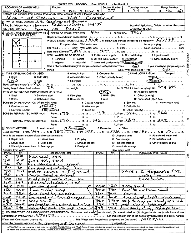
T34S, R40W, Sec. 27 NW NW |
U.S. Geological Survey | 400 ft. | 174.6 ft. | Monitoring well/observation/piezometer | Constructed | 26-May-1999 | Scan | ||
|
T34S, R40W, Sec. 28 NW SW SE |
Gabbert and Jones | 320 ft. | 175 ft. | 80 gpm. | Oil Field Water Supply | Bohn 1 | Constructed | 01-Aug-1990 | |
|
T34S, R40W, Sec. 28 SW SW SE NE |
Kuntz, Aaron | 373 ft. | 183 ft. | 554 gpm. | Irrigation | Constructed | 07-Mar-2014 |
KOLAR |
|
|
T34S, R40W, Sec. 28 SW SE NE |
Perkins, Ivan | 390 ft. | 171 ft. | Irrigation | Constructed | 31-Jan-1997 | |||
|
T34S, R40W, Sec. 28 NW NW NE |
Seaboard Farms | 360 ft. | 175 ft. | 100 gpm. | Domestic, Livestock | Well 2 | Constructed | 12-Feb-1996 | |
|
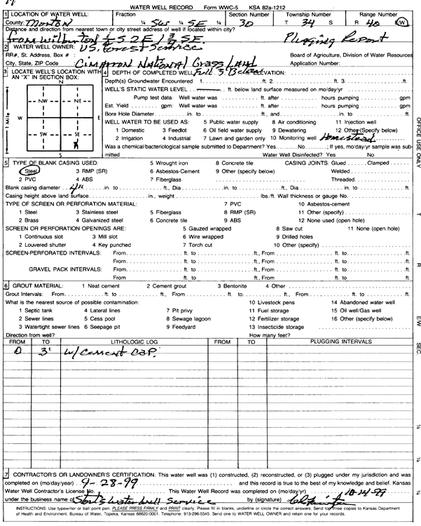
T34S, R40W, Sec. 30 SW SE |
Cimarron National Grassland | 3 ft. | Domestic | Well 14 | Plugged | 28-Sep-1999 | Scan | ||
|
T34S, R40W, Sec. 30 C SW |
Morton County Grazing Assoc. | 280 ft. | 153 ft. | 35 gpm. | Domestic, Livestock | Constructed | 13-Apr-1988 | ||
|
T34S, R40W, Sec. 33 NE SW SW |
Perkins, Calvin | 376 ft. | 188 ft. | 1800 gpm. | Irrigation | Constructed | 13-May-1996 | ||
|
T34S, R40W, Sec. 33 NE NW NW |
Seaboard Farms | 360 ft. | 163 ft. | 130 gpm. | Domestic, Livestock | Calvin East Well | Constructed | 19-Sep-1997 | |
|
T34S, R40W, Sec. 33 NW SW SW |
Seaboard Farms | 370 ft. | 170 ft. | 100 gpm. | Domestic, Livestock | Well 1 | Constructed | 10-Feb-1996 | |
|
T34S, R40W, Sec. 33 NE NW NW |
Seaboard Farms | 360 ft. | 160 ft. | 100 gpm. | Domestic, Livestock | Well 3 | Constructed | 13-Feb-1996 | |
|
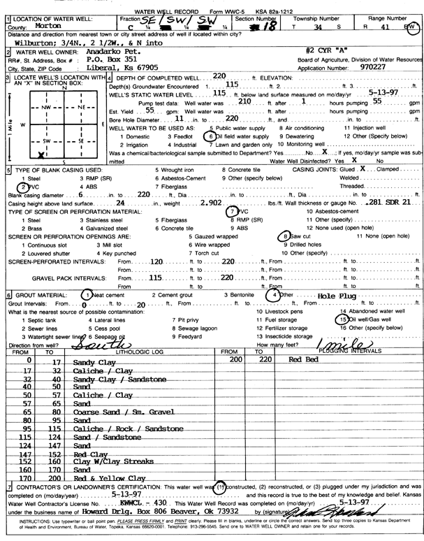
T34S, R40W, Sec. 34 SE SE NW |
Anadarko Petroleum Corp. | 336 ft. | 220 ft. | Oil Field Water Supply | Constructed | 05-Dec-2001 | Scan | ||
|
T34S, R40W, Sec. 35 SW SW SW |
Bressler, Wesley | 458 ft. | 196 ft. | Irrigation | Constructed | 23-Feb-1998 | |||
|
T34S, R40W, Sec. 35 SW NW NE NE |
Millemon, Hester | 430 ft. | 205 ft. | 15 gpm. | Domestic | Constructed | 04-Jun-2013 |
KOLAR |
|
|
T34S, R40W, Sec. 36 SE SE SE |
Hayward, Jack | 490 ft. | 196 ft. | Irrigation | Constructed | 28-Feb-1994 | |||
|
T34S, R40W, Sec. 36 NE NE SE |
Johnson, Boyd | 470 ft. | 200 ft. | Irrigation | Constructed | 24-Mar-1997 | |||
|
T34S, R41W, Sec. 2 NE NE NE |
Cimarron National Grassland | 135 ft. | 95 ft. | (unstated)/abandoned | Plugged | 22-Nov-1997 | |||
|
T34S, R41W, Sec. 4 C SW NW |
Anadarko Petroleum Corp. | 180 ft. | 81 ft. | 60 gpm. | Oil Field Water Supply | Cherokee D 1 | Constructed | 08-Jan-1982 | |
|
T34S, R41W, Sec. 4 NE NE NW |
Schick, Raymond | 100 ft. | 88 ft. | 8 gpm. | Domestic | Constructed | 02-Feb-1992 | ||
|
T34S, R41W, Sec. 4 SW SW SE |
Tucker, John | 195 ft. | 70 ft. | 25 gpm. | Domestic | Constructed | 12-Sep-1994 | ||
|
T34S, R41W, Sec. 6 C SW SW |
Anadarko Petroleum Corp. | 220 ft. | 60 ft. | 60 gpm. | Oil Field Water Supply | Goddard B 2 | Constructed | 24-Dec-1981 | |
|
T34S, R41W, Sec. 8 NW SE SE |
Gabbert and Jones | 180 ft. | 82 ft. | 55 gpm. | Oil Field Water Supply | Wacker G 1 | Constructed | 02-Feb-1985 | |
|
T34S, R41W, Sec. 8 SW SW SW |
Morton County Grazing Assoc. | 140 ft. | 99 ft. | 25 gpm. | Domestic, Livestock | Constructed | 20-Sep-1977 | ||
|
T34S, R41W, Sec. 8 C NE NE |
U.S. Forest Service | 300 ft. | 99 ft. | Domestic, Livestock | A-2 | Plugged | 24-Sep-1992 | ||
|
T34S, R41W, Sec. 9 C NE SE |
Cimarron National Grassland | 110 ft. | Domestic, Livestock | Plugged | 16-Oct-1996 | ||||
|
T34S, R41W, Sec. 9 SW SW NE NW |
Lucky, Jeremy | 180 ft. | 100 ft. | 30 gpm. | Domestic, Livestock | Constructed | 28-Aug-2018 | ||
|
T34S, R41W, Sec. 9 SE NE NE |
U.S. Forest Service | 185 ft. | 111 ft. | 25 gpm. | Domestic | Well 1 | Constructed | 06-Jun-1995 | |
|
T34S, R41W, Sec. 10 C NW NW |
Anadarko Petroleum Corp. | 240 ft. | 96 ft. | 45 gpm. | Oil Field Water Supply | Moore F 1 | Constructed | 12-Dec-1981 | |
|
T34S, R41W, Sec. 10 C SE NW |
U.S. Forest Service | 173 ft. | 89 ft. | Domestic, Livestock | A-11 | Plugged | 06-Oct-1992 | ||
|
T34S, R41W, Sec. 10 C NW SE |
U.S. Forest Service | 110 ft. | 98 ft. | Domestic, Livestock | B-5 | Plugged | 15-Oct-1992 | ||
|
T34S, R41W, Sec. 13 SW SW SW |
Coen, Donald | 310 ft. | 160 ft. | 40 gpm. | Domestic | Constructed | 16-Aug-1976 | ||
|
T34S, R41W, Sec. 13 SW SE SE NW |
Lucky, Jeremy | 360 ft. | 175 ft. | 50 gpm. | Domestic, Livestock | Constructed | 28-Aug-2018 | ||
|
T34S, R41W, Sec. 14 NE SW SW |
Oxy USA, Inc. | 265 ft. | 160 ft. | 90 gpm. | Oil Field Water Supply | Marks | Constructed | 09-Nov-1996 | |
|
T34S, R41W, Sec. 14 SE NW SE |
Oxy USA, Inc. | 320 ft. | 150 ft. | 100 gpm. | Oil Field Water Supply | Bordeno A 1 | Constructed | 04-Aug-2004 | |
|
T34S, R41W, Sec. 15 NW SW NW |
Coen, Jay D. | 181 ft. | 131 ft. | Domestic | Constructed | 06-Aug-1993 | |||
|
T34S, R41W, Sec. 15 SW SW NE |
U.S. Forest Service | 250 ft. | 138 ft. | Domestic, Livestock | A-1 | Plugged | 06-Oct-1992 | ||
|
T34S, R41W, Sec. 16 C SE SE |
Anadarko Petroleum Corp. | 320 ft. | 150 ft. | 100 gpm. | Oil Field Water Supply | Wilburton 2 | Constructed | 26-Aug-1996 | |
|
T34S, R41W, Sec. 17 SW SW SW |
Anadarko Petroleum Corp. | 220 ft. | 120 ft. | Oil Field Water Supply | Hill B 1 | Plugged | 01-Aug-1984 | ||
|
T34S, R41W, Sec. 17 SW SW SW |
Anadarko Petroleum Corp. | 220 ft. | 120 ft. | 65 gpm. | Oil Field Water Supply | Hill B 1 | Constructed | 09-Jul-1984 | |
|
T34S, R41W, Sec. 18 SE SW SW |
Anadarko Petroleum Corp. | 220 ft. | 115 ft. | 55 gpm. | Oil Field Water Supply | Cyr A 2 | Constructed | 13-May-1997 | Scan |
| View page: < Prev || 11 || 12 || 13 || 14 || 15 || 16 || 17 || 18 || 19 || 20 || Next > | |||||||||