Select location of well to view details.
Click on column heading to sort.
|
|
|
County: Morton Select location of well to view details. Click on column heading to sort. |
|
|
|
| View page: < Prev || 11 || 12 || 13 || 14 || 15 || 16 || 17 || 18 || 19 || 20 || Next > | |||||||||
| T-R-S | Owner | Well Depth Ascend. Desc. |
Static Water Level Ascend. Desc. |
Est. Yield Ascend. Desc. |
Well Use | Other ID | Action Taken | Completion Date Ascend. Desc. |
Scan? |
|
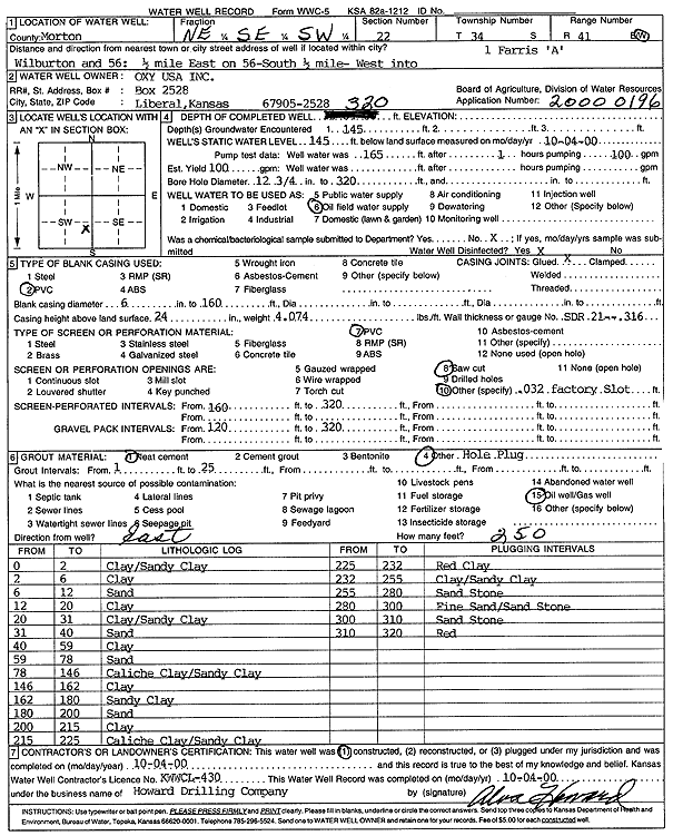
T34S, R41W, Sec. 22 NE SE SW |
Oxy USA, Inc. | 320 ft. | 145 ft. | 100 gpm. | Oil Field Water Supply | Farris A 1 | Constructed | 04-Oct-2000 | Scan |
|
T34S, R41W, Sec. 22 SE SE SE |
Thomason, Clint | 320 ft. | 220 ft. | Irrigation | Constructed | 07-Apr-1984 | |||
|
T34S, R41W, Sec. 23 NW SE SE |
Oxy USA, Inc. | 305 ft. | 175 ft. | 95 gpm. | Oil Field Water Supply | Tucker B 2 | Constructed | 07-Nov-1996 | |
|
T34S, R41W, Sec. 23 SE SW SW |
Seaboard Corp. | 285 ft. | 185 ft. | Feedlot | Constructed | 07-Aug-1996 | |||
|
T34S, R41W, Sec. 23 NW NW SW |
Thomason, Clint | 292 ft. | Irrigation | Constructed | 12-Apr-1984 | ||||
|
T34S, R41W, Sec. 24 C NE |
Cimarron National Grassland | 110 ft. | Domestic, Livestock | Plugged | 25-Oct-1996 | ||||
|
T34S, R41W, Sec. 24 SW NE NE |
Oxy USA, Inc. | 305 ft. | 160 ft. | 70 gpm. | Oil Field Water Supply | Becker E 2 | Constructed | 15-Nov-1996 | |
|
T34S, R41W, Sec. 25 SW NE NE |
Oxy USA, Inc. | 325 ft. | 175 ft. | 85 gpm. | Oil Field Water Supply | Holt A 2 | Constructed | 08-Nov-1996 | |
|
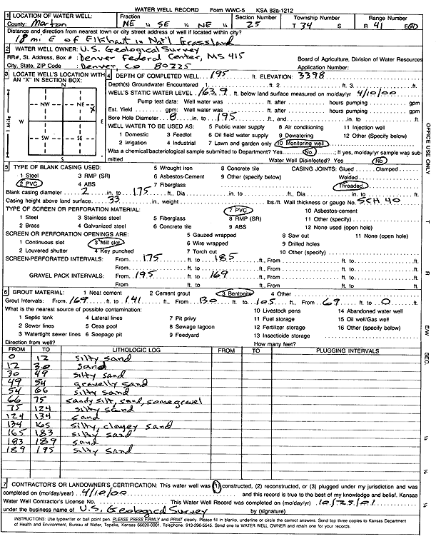
T34S, R41W, Sec. 25 NE SE NE |
U.S. Geological Survey | 195 ft. | 163.9 ft. | Monitoring well/observation/piezometer | Constructed | 10-Apr-2000 | Scan | ||
|
T34S, R41W, Sec. 26 C NE NE |
Oxy USA, Inc. | 320 ft. | 136 ft. | 80 gpm. | Oil Field Water Supply | Stanford A 2 | Constructed | 11-Nov-1996 | |
|
T34S, R41W, Sec. 26 NW NW SW |
Thomason, Clint | 288 ft. | 145 ft. | Irrigation | Constructed | 31-May-1982 | |||
|
T34S, R41W, Sec. 26 NE NE NW |
Thomason, Clint | 352 ft. | Irrigation | Constructed | 19-Apr-1984 | ||||
|
T34S, R41W, Sec. 26 SE NW NW |
Thomason, Clint | 297 ft. | Irrigation | Constructed | 15-Apr-1980 | ||||
|
T34S, R41W, Sec. 26 SE SW SE |
Thomasson, Clint | 289 ft. | 155 ft. | Irrigation | Constructed | 30-Aug-1976 | |||
|
T34S, R41W, Sec. 27 SE SE SE |
Morton County | 187 ft. | 165.22 ft. | Monitoring well/observation/piezometer | MW 7 | Constructed | 26-Jun-2021 | ||
|
T34S, R41W, Sec. 27 NE SE SE |
Morton County | 184.2 ft. | 154.21 ft. | Monitoring well/observation/piezometer | MW 6 | Constructed | 25-Jun-2021 | ||
|
T34S, R41W, Sec. 27 SE SW NW NW |
Morton County | 159 ft. | 144 ft. | Monitoring well/observation/piezometer | MW 5 | Constructed | 16-Mar-2019 | ||
|
T34S, R41W, Sec. 27 NW SE NW NW |
Morton County | 158 ft. | 149 ft. | Monitoring well/observation/piezometer | MW 4 | Constructed | 18-Mar-2019 | ||
|
T34S, R41W, Sec. 27 NE NW NW |
Morton County Landfill | 165 ft. | 153.3 ft. | Monitoring well/observation/piezometer | MW 3 | Constructed | 14-May-1993 | ||
|
T34S, R41W, Sec. 27 NE SW SW |
Morton County Landfill | 260 ft. | 145 ft. | 80 gpm. | Domestic | Constructed | 03-Oct-1975 | ||
|
T34S, R41W, Sec. 27 NE NW NW |
Morton County Landfill | 160 ft. | 138 ft. | Monitoring well/observation/piezometer | MW 1 | Constructed | 12-May-1993 | ||
|
T34S, R41W, Sec. 27 NE NW NW |
Morton County Landfill | 160 ft. | 141.4 ft. | Monitoring well/observation/piezometer | MW 2 | Constructed | 13-May-1993 | ||
|
T34S, R41W, Sec. 27 NW NW NW |
Morton County Road Dept. | 210 ft. | 149 ft. | Industrial | Plugged | 20-Aug-1991 | Scan | ||
|
T34S, R41W, Sec. 28 NW NW SW |
Barnes, Bill | 290 ft. | 131 ft. | 30 gpm. | Domestic | Constructed | 23-Jan-1995 | ||
|
T34S, R41W, Sec. 28 SE SW NW |
Oxy USA, Inc. | 280 ft. | 160 ft. | Oil Field Water Supply | WMSU 303 | Plugged | 24-Apr-1996 | ||
|
T34S, R41W, Sec. 28 SE SW NW |
Oxy USA, Inc. | 280 ft. | 160 ft. | 90 gpm. | Oil Field Water Supply | WMSU 303 | Constructed | 27-Mar-1996 | |
|
T34S, R41W, Sec. 29 N2 NE SE |
Oxy USA, Inc. | 265 ft. | 140 ft. | Oil Field Water Supply | WMSU 2A02 | Plugged | 22-Apr-1997 | ||
|
T34S, R41W, Sec. 29 SE NE NW |
Oxy USA, Inc. | 240 ft. | 100 ft. | Oil Field Water Supply | Stewart A 2 | Plugged | 18-Aug-1997 | ||
|
T34S, R41W, Sec. 29 SE NE NW |
Oxy USA, Inc. | 280 ft. | 100 ft. | 100 gpm. | Oil Field Water Supply | Stewart A 2 | Constructed | 21-May-1997 | |
|
T34S, R41W, Sec. 29 N2 NE SE |
Oxy USA, Inc. | 265 ft. | 140 ft. | 90 gpm. | Oil Field Water Supply | WMSU 2A02 | Constructed | 19-Mar-1997 | |
|
T34S, R41W, Sec. 31 C S2 SW |
Anadarko Petroleum Corp. | 280 ft. | 80 ft. | Oil Field Water Supply | Nusser A 1 | Constructed | 15-Jun-1994 | ||
|
T34S, R41W, Sec. 32 C NE |
Cities Service Co. | 260 ft. | 140 ft. | 50 gpm. | Oil Field Water Supply | Constructed | 30-Nov-1976 | ||
|
T34S, R41W, Sec. 32 NW NW SE |
Oxy USA, Inc. | 260 ft. | 135 ft. | 90 gpm. | Oil Field Water Supply | Pearson C 3 | Constructed | 06-Feb-1996 | |
|
T34S, R41W, Sec. 32 SE NW NE |
Oxy USA, Inc. | 280 ft. | 148 ft. | 100 gpm. | Oil Field Water Supply | WMSU 902 | Constructed | 28-May-1997 | |
|
T34S, R41W, Sec. 33 SW SW NE |
Bressler, Wesley | 265 ft. | 155 ft. | Irrigation | Constructed | 16-Jun-1976 | |||
|
T34S, R41W, Sec. 33 SW NE SW |
Cities Service Co. | 250 ft. | 165 ft. | 65 gpm. | Oil Field Water Supply | WMSU 1703 | Constructed | 16-Sep-1983 | |
|
T34S, R41W, Sec. 33 SE SW NE |
Cities Service Co. | 260 ft. | 158 ft. | 150 gpm. | Industrial | Constructed | 01-Oct-1985 | ||
|
T34S, R41W, Sec. 33 SE SE NW |
Cities Service Co. | 240 ft. | Domestic | Plugged | 08-Nov-1978 | ||||
|
T34S, R41W, Sec. 33 SE SW NE |
Cities Service Co. | 260 ft. | 158 ft. | 150 gpm. | Industrial | Constructed | 18-Sep-1985 | ||
|
T34S, R41W, Sec. 33 C NW |
Cities Service Co. | 240 ft. | 160 ft. | 60 gpm. | Oil Field Water Supply | Constructed | 21-Jun-1977 | ||
|
T34S, R41W, Sec. 33 SE SE NE |
Cities Service Co. | 270 ft. | 150 ft. | Industrial | Plugged | 10-Oct-1985 | |||
|
T34S, R41W, Sec. 33 SW NE SW |
Cities Service Co. | 250 ft. | 165 ft. | Oil Field Water Supply | WMSU 1703 | Plugged | 21-Mar-1984 | ||
|
T34S, R41W, Sec. 33 NE NE NE |
OHanlon, Steve | 260 ft. | Domestic | Constructed | 04-Jun-2011 | ||||
|
T34S, R41W, Sec. 33 NW NE SW |
Oxy USA, Inc. | 280 ft. | 126 ft. | 100 gpm. | Oil Field Water Supply | WMSU 1705 | Constructed | 30-Jun-1998 | |
|
T34S, R41W, Sec. 33 NE NE SE |
U.S. Forest Service | 260 ft. | 165 ft. | 30 gpm. | Domestic, Livestock | Constructed | 21-Jun-1978 | ||
|
T34S, R41W, Sec. 34 SW SW SW |
Bressler, Wesley | 294 ft. | 175 ft. | Irrigation | Constructed | 13-Nov-1976 | |||
|
T34S, R41W, Sec. 34 SW NE SW |
Bressler, Wesley | 285 ft. | 176 ft. | Irrigation | Constructed | 17-Jun-1976 | |||
|
T34S, R41W, Sec. 34 SW NE NE |
Oxy USA, Inc. | 285 ft. | 140 ft. | 30 gpm. | Oil Field Water Supply | Matern A 3 | Constructed | 13-Nov-1996 | |
|
T34S, R41W, Sec. 35 C NW |
Cimarron National Grassland | 70 ft. | 69 ft. | Domestic, Livestock | Plugged | 10-Oct-1996 | |||
|
T34S, R41W, Sec. 35 NW SE SE |
Morton County Grazing Assoc. | 250 ft. | 150 ft. | 30 gpm. | Domestic, Livestock | Constructed | 13-Mar-1986 | ||
| View page: < Prev || 11 || 12 || 13 || 14 || 15 || 16 || 17 || 18 || 19 || 20 || Next > | |||||||||