Select location of well to view details.
Click on column heading to sort.
|
|
|
County: Reno Select location of well to view details. Click on column heading to sort. |
|
|
|
| View page: < Prev || 101 || 102 || 103 || 104 || 105 || 106 || 107 || 108 || 109 || 110 || Next > | |||||||||
| T-R-S | Owner | Well Depth Ascend. Desc. |
Static Water Level Ascend. Desc. |
Est. Yield Ascend. Desc. |
Well Use | Other ID | Action Taken | Completion Date Ascend. Desc. |
Scan? |
|
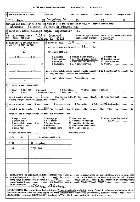
T22S, R9W, Sec. 35 NE NE NW |
Phillips Exploration, Co. | 100 ft. | 18 ft. | Oil Field Water Supply | Plugged | 12-Feb-2004 | Scan | ||
|
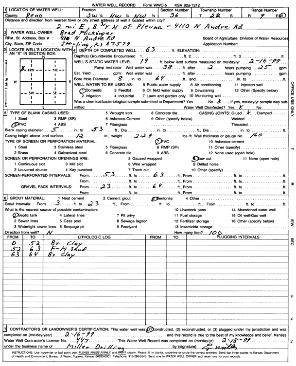
T22S, R9W, Sec. 36 SW NW NW |
Flickinger, Brad | 63 ft. | 19 ft. | Domestic | Constructed | 16-Feb-1999 | Scan | ||
|
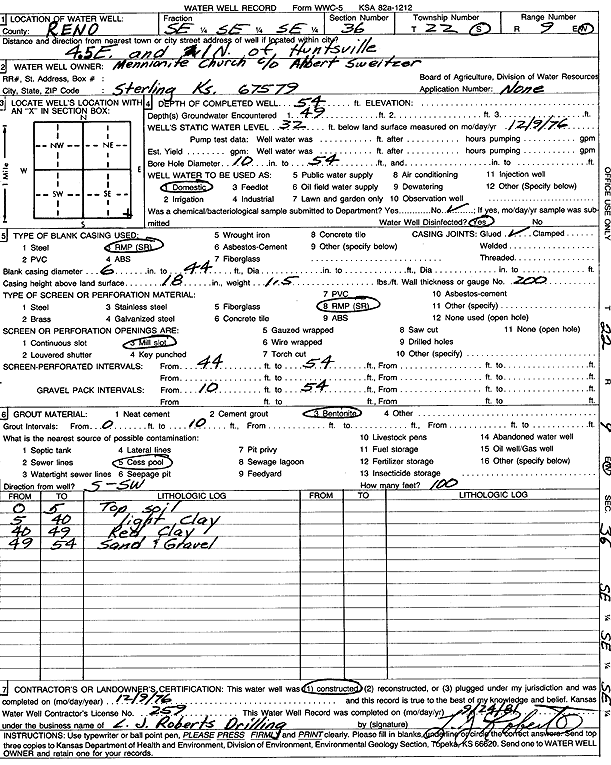
T22S, R9W, Sec. 36 SE SE SE |
Mennonite Church | 54 ft. | 32 ft. | Domestic | Constructed | 09-Dec-1976 | Scan | ||
|
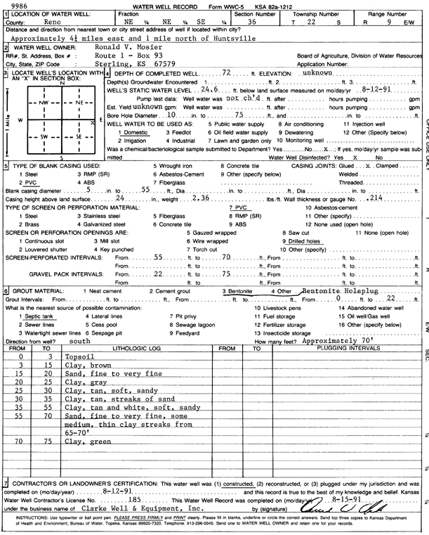
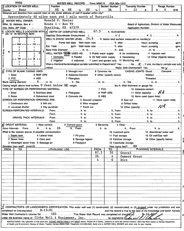
T22S, R9W, Sec. 36 NE NE SE |
Mosier, Ronald V. | 72 ft. | 24.6 ft. | Domestic | Constructed | 12-Aug-1991 | Scan | ||
|
T22S, R9W, Sec. 36 NE NE SE |
Mosier, Ronald V. | 67.5 ft. | 24.6 ft. | Domestic | Plugged | 13-Aug-1991 | Scan | ||
|
T22S, R9W, Sec. 36 SE SE NE |
Williams, Jonathan | 85 ft. | 25 ft. | 45 gpm. | Domestic, Livestock | Constructed | 28-Feb-2023 |
KOLAR |
|
|
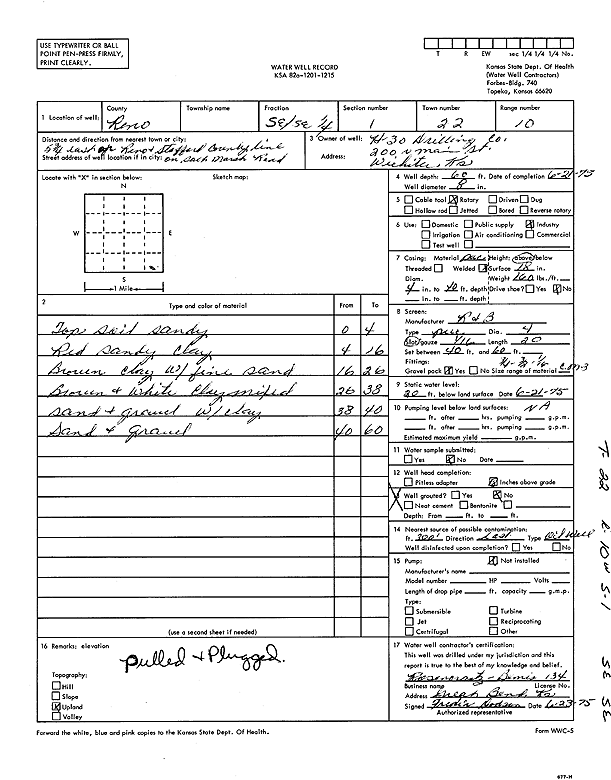
T22S, R10W, Sec. 1 SE SE |
H-30 Drilling, Inc. | 60 ft. | 20 ft. | Industrial | Constructed | 21-Jun-1975 | Scan | ||
|
T22S, R10W, Sec. 1 NW SE NE |
KGS/GMD 5 | 45 ft. | 29.8 ft. | Monitoring well/observation/piezometer | 24-3 | Constructed | 13-Aug-1981 | ||
|
T22S, R10W, Sec. 1 NW SE NE |
KGS/GMD 5 | 145 ft. | 31.16 ft. | Monitoring well/observation/piezometer | 24-1 | Constructed | 12-Aug-1981 | ||
|
T22S, R10W, Sec. 1 NW SE NE |
KGS/GMD 5 | 136 ft. | 30.24 ft. | Monitoring well/observation/piezometer | 24-2 | Constructed | 12-Aug-1981 | ||
|
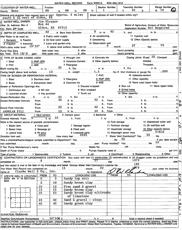
T22S, R10W, Sec. 1 NW NW SW |
Sleeper, Jim | 42 ft. | 10.83 ft. | Domestic | Constructed | 27-Aug-1979 | Scan | ||
|
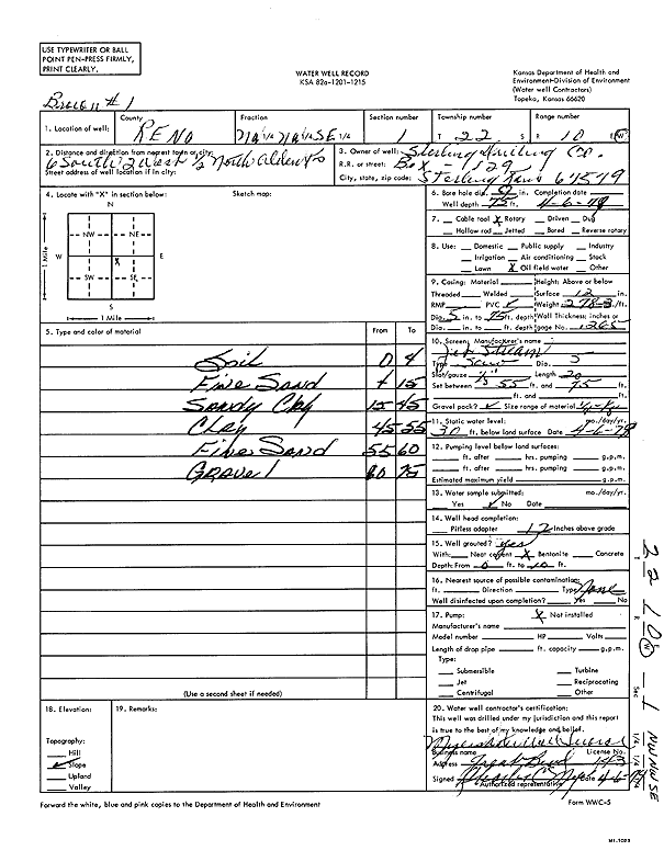
T22S, R10W, Sec. 1 NW NW SE |
Sterling Drilling Co. | 75 ft. | 30 ft. | Oil Field Water Supply | Constructed | 06-Apr-1978 | Scan | ||
|
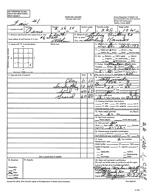
T22S, R10W, Sec. 1 C SE SE |
Sterling Drilling Co. | 80 ft. | 18 ft. | Oil Field Water Supply | Fair 1 | Constructed | 03-Sep-1977 | Scan | |
|
T22S, R10W, Sec. 1 NW SE NE |
Stout, Roger | 60 ft. | 30 ft. | Domestic, Livestock | Constructed | 23-Aug-2006 | |||
|
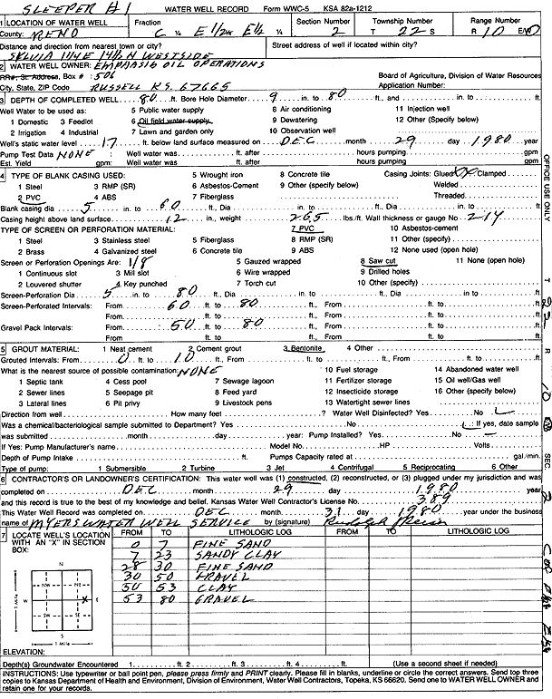
T22S, R10W, Sec. 2 C E2 E2 |
Emphasis Oil Operations | 80 ft. | 17 ft. | Oil Field Water Supply | Sleeper 1 | Constructed | 29-Dec-1980 | Scan | |
|
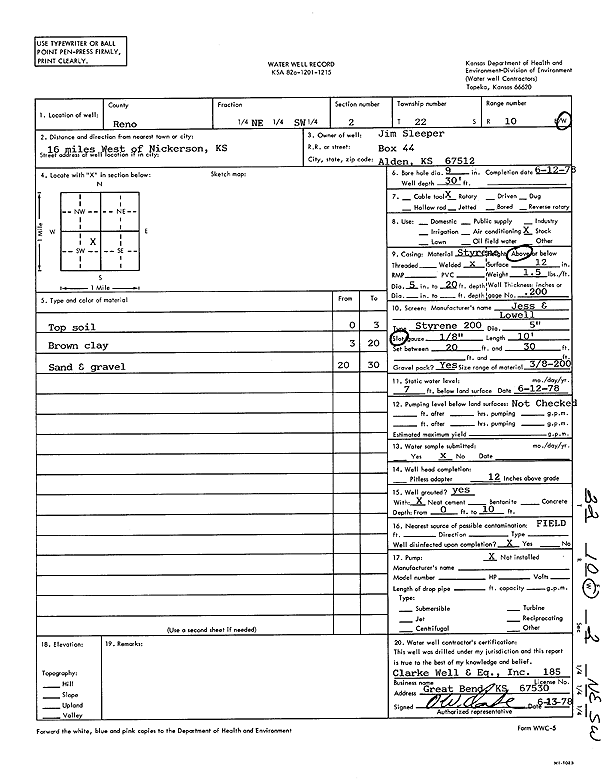
T22S, R10W, Sec. 2 NE SW |
Sleeper, Jim | 30 ft. | 7 ft. | Domestic, Livestock | Constructed | 12-Jun-1978 | Scan | ||
|
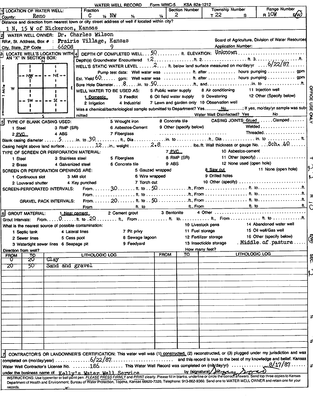
T22S, R10W, Sec. 2 C NW |
Wilson, Charles | 50 ft. | 2 ft. | 60 gpm. | Domestic | Constructed | 22-Jun-1987 | Scan | |
|
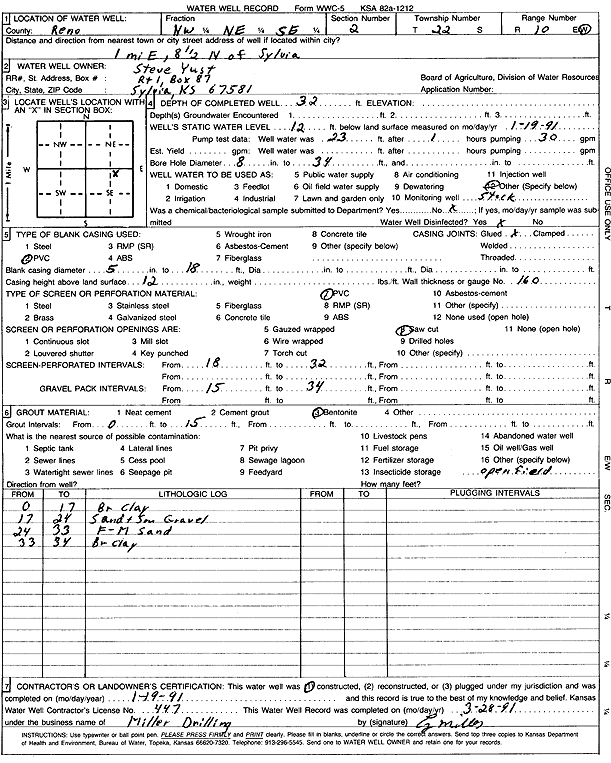
T22S, R10W, Sec. 2 NW NE SE |
Yust, Steve | 32 ft. | 12 ft. | Domestic, Livestock | Constructed | 19-Jan-1991 | Scan | ||
|
T22S, R10W, Sec. 3 N2 SW SW SE |
Carrie Exploration | 60 ft. | 15 ft. | Oil Field Water Supply | Constructed | 07-Dec-2012 | |||
|
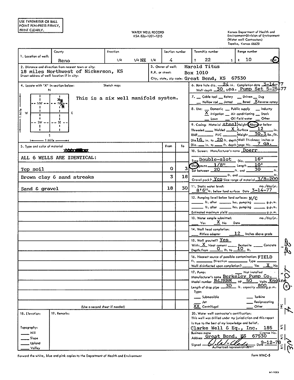
T22S, R10W, Sec. 4 |
Titus | 42 ft. | Test hole/well | Constructed | 11-Nov-1974 | ||||
|
T22S, R10W, Sec. 4 |
Titus | 42 ft. | 500 gpm. | Test hole/well | Constructed | 05-Nov-1974 | |||
|
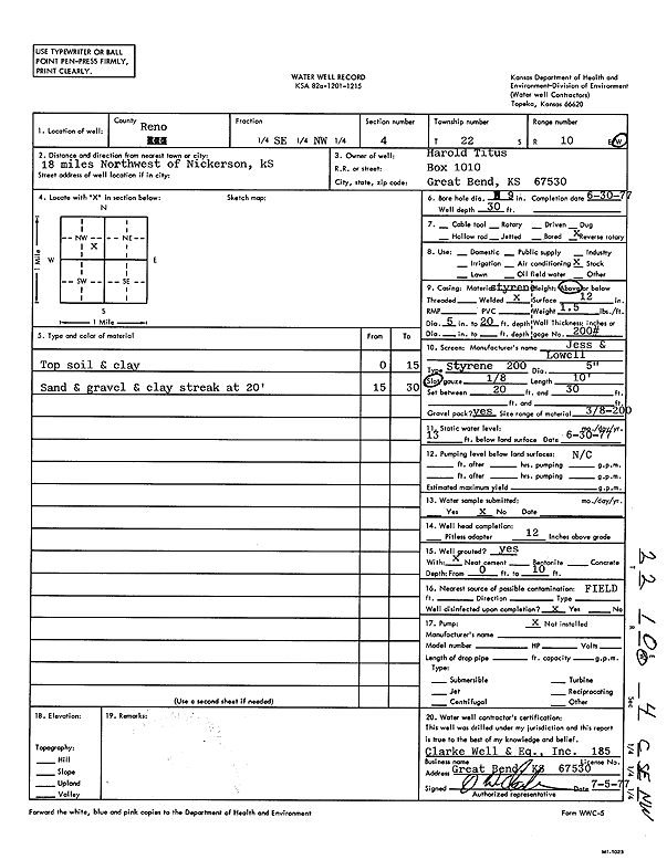
T22S, R10W, Sec. 4 NE |
Titus, Harold | 30 ft. | 8.5 ft. | Irrigation | Constructed | 14-Mar-1977 | |||
|
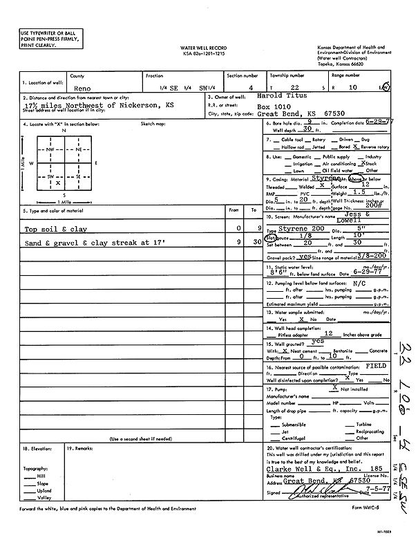
T22S, R10W, Sec. 4 SE |
Titus, Harold | 32 ft. | 14.5 ft. | Irrigation | Constructed | 13-Jul-1977 | |||
|
T22S, R10W, Sec. 4 SW |
Titus, Harold | 60 ft. | 9 ft. | Test hole/well | Constructed | 23-Sep-1974 | |||
|
T22S, R10W, Sec. 4 SE |
Titus, Harold | 32 ft. | 14.5 ft. | Irrigation | Constructed | 05-Jul-1977 | |||
|
T22S, R10W, Sec. 4 SE |
Titus, Harold | 32 ft. | 14.5 ft. | Irrigation | Constructed | 05-Jul-1977 | |||
|
T22S, R10W, Sec. 4 SE |
Titus, Harold | 40 ft. | 17 ft. | Irrigation | Constructed | 20-Jul-1977 | |||
|
T22S, R10W, Sec. 4 |
Titus, Harold | 42 ft. | 8 ft. | Test hole/well | Constructed | 31-Oct-1974 | |||
|
T22S, R10W, Sec. 4 SE |
Titus, Harold | 40 ft. | 17 ft. | Irrigation | Constructed | 21-Jul-1977 | |||
|
T22S, R10W, Sec. 4 SE |
Titus, Harold | 32 ft. | 14.5 ft. | Irrigation | Constructed | 05-Jul-1977 | |||
|
T22S, R10W, Sec. 4 SE |
Titus, Harold | 32 ft. | 14.5 ft. | Irrigation | Constructed | 05-Jul-1977 | |||
|
T22S, R10W, Sec. 4 NE |
Titus, Harold | 30 ft. | 8.5 ft. | Irrigation | Constructed | 14-Mar-1977 | |||
|
T22S, R10W, Sec. 4 NE |
Titus, Harold | 30 ft. | 8.5 ft. | Irrigation | Constructed | 14-Mar-1977 | |||
|
T22S, R10W, Sec. 4 NE |
Titus, Harold | 30 ft. | 8.5 ft. | Irrigation | Constructed | 14-Mar-1977 | |||
|
T22S, R10W, Sec. 4 NE |
Titus, Harold | 30 ft. | 8.5 ft. | Irrigation | Constructed | 14-Mar-1977 | |||
|
T22S, R10W, Sec. 4 NE NW |
Titus, Harold | 30 ft. | 12 ft. | Domestic, Livestock | Constructed | 30-Jun-1977 | Scan | ||
|
T22S, R10W, Sec. 4 SE |
Titus, Harold | 40 ft. | 17 ft. | Irrigation | Constructed | 20-Jul-1977 | |||
|
T22S, R10W, Sec. 4 SE |
Titus, Harold | 32 ft. | 14.5 ft. | Irrigation | Constructed | 13-Jul-1977 | |||
|
T22S, R10W, Sec. 4 SE |
Titus, Harold | 32 ft. | 14.5 ft. | Irrigation | Constructed | 05-Jul-1977 | |||
|
T22S, R10W, Sec. 4 SE SW |
Titus, Harold | 30 ft. | 8.5 ft. | Domestic, Livestock | Constructed | 29-Jun-1977 | Scan | ||
|
T22S, R10W, Sec. 4 SE |
Titus, Harold | 32 ft. | 14.5 ft. | Irrigation | Constructed | 05-Jul-1977 | |||
|
T22S, R10W, Sec. 4 NE |
Titus, Harold | 30 ft. | 8.5 ft. | Irrigation | Constructed | 14-Mar-1977 | Scan | ||
|
T22S, R10W, Sec. 4 SE |
Titus, Harold | 40 ft. | 17 ft. | Irrigation | Constructed | 21-Jul-1977 | |||
|
T22S, R10W, Sec. 4 SE |
Titus, Harold | 40 ft. | 17 ft. | Irrigation | Constructed | 20-Jul-1977 | Scan | ||
|
T22S, R10W, Sec. 4 SE NW |
Titus, Harold | 30 ft. | 13 ft. | Domestic, Livestock | Constructed | 30-Jun-1977 | Scan | ||
|
T22S, R10W, Sec. 4 SE NE SW |
Widener, Monte E. | 65 ft. | 17 ft. | Oil Field Water Supply | M E W 1-4 | Plugged | 30-Jan-2014 | ||
|
T22S, R10W, Sec. 4 SE NE SW |
Widener, Monte E. | 80 ft. | 17 ft. | 80 gpm. | Oil Field Water Supply | M E W 1-4 | Constructed | 10-Sep-2012 | |
|
T22S, R10W, Sec. 5 E2 SE |
Anthony, Dean | 42 ft. | 13.08 ft. | Irrigation | well 7 | Constructed | 10-Jan-1978 | ||
|
T22S, R10W, Sec. 5 E2 SE |
Anthony, Dean | 42 ft. | 13.1 ft. | Irrigation | well 1 | Constructed | 24-Aug-1977 | Scan | |
|
T22S, R10W, Sec. 5 E2 SE |
Anthony, Dean | 42 ft. | 13.08 ft. | Irrigation | well 5 | Constructed | 10-Jan-1978 | ||
| View page: < Prev || 101 || 102 || 103 || 104 || 105 || 106 || 107 || 108 || 109 || 110 || Next > | |||||||||