Select location of well to view details.
Click on column heading to sort.
|
|
|
County: Seward Select location of well to view details. Click on column heading to sort. |
|
|
|
| View page: < Prev || 31 || 32 || 33 || 34 || 35 || 36 || 37 || 38 || 39 || 40 || Next > | |||||||||
| T-R-S | Owner | Well Depth Ascend. Desc. |
Static Water Level Ascend. Desc. |
Est. Yield Ascend. Desc. |
Well Use | Other ID | Action Taken | Completion Date Ascend. Desc. |
Scan? |
|
T34S, R32W, Sec. 18 C NW SW |
Anadarko Production | 280 ft. | 128 ft. | 60 gpm. | Oil Field Water Supply | Condit Unit 6-2 | Constructed | 23-Jul-1980 | |
|
T34S, R32W, Sec. 19 C SE SE |
Anadarko Petroleum Corp. | 325 ft. | 200 ft. | 100 gpm. | Oil Field Water Supply | Cady A 2 | Constructed | 15-Aug-1996 | |
|
T34S, R32W, Sec. 19 SW NW NW NW |
Barkley, Andrew | 362 ft. | 224 ft. | 50 gpm. | Domestic | Constructed | 28-Feb-2020 | ||
|
T34S, R32W, Sec. 19 SW SW NW |
J and R Sand | 340 ft. | 190 ft. | 100 gpm. | Industrial | Constructed | 05-Aug-1992 | ||
|
T34S, R32W, Sec. 19 E2 NW |
Means, Ed | 340 ft. | 180 ft. | 90 gpm. | Domestic | Constructed | 04-Apr-1996 | ||
|
T34S, R32W, Sec. 19 SE NW NW NW |
Scott, Don | 345 ft. | 219 ft. | 50 gpm. | Domestic | Constructed | 18-Sep-2019 | ||
|
T34S, R32W, Sec. 19 NW NW NW |
Scott, Don | 360 ft. | 225 ft. | 90 gpm. | Domestic, Livestock | Constructed | 25-Oct-2023 |
KOLAR |
|
|
T34S, R32W, Sec. 19 SW SW NW |
Sporer Land Development | 333 ft. | 230 ft. | Other
(supply well) |
Plugged | 25-Aug-2022 |
KOLAR |
||
|
T34S, R32W, Sec. 19 NE NW SW |
Sporer Land Development | 405 ft. | 222 ft. | 200 gpm. | Other
(SUPPLY WELL) |
Constructed | 09-Mar-2022 |
KOLAR |
|
|
T34S, R32W, Sec. 19 NE NE NE |
Western Star RV Ranch | 260 ft. | 200 ft. | 100 gpm. | Domestic | Constructed | 05-Jun-2005 | ||
|
T34S, R32W, Sec. 19 NW NW NW |
291 ft. | 204 ft. | 50 gpm. | Domestic | Constructed | 03-Dec-2008 | |||
|
T34S, R32W, Sec. 20 NE SW SW SE |
Garinger, John | 313 ft. | 214 ft. | 50 gpm. | Domestic | Constructed | 08-Jun-2012 |
KOLAR |
|
|
T34S, R32W, Sec. 20 SE SE NW |
Hittle, Larry | 375 ft. | 206 ft. | Irrigation | Constructed | 10-Sep-2004 | |||
|
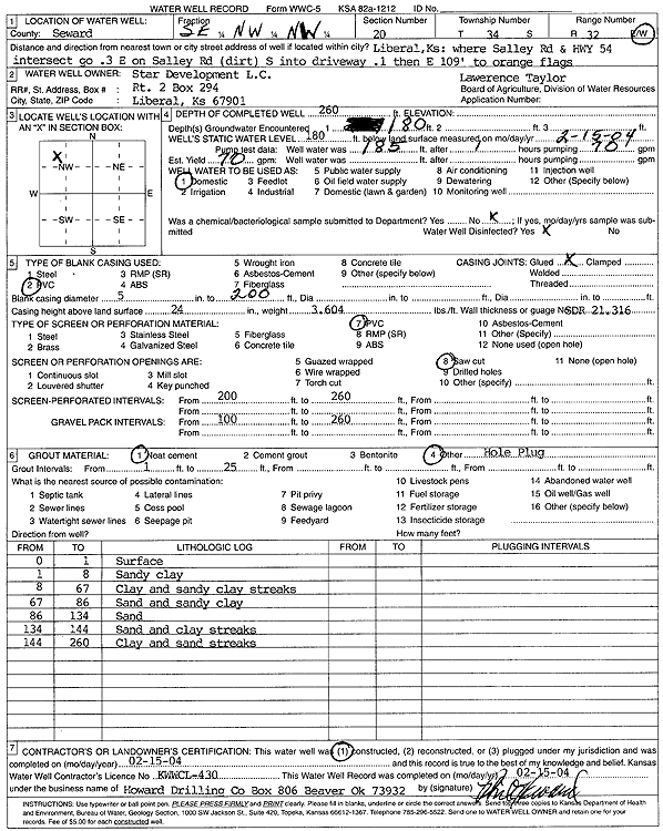
T34S, R32W, Sec. 20 SE NW NW |
Star Development, L.C. | 260 ft. | 180 ft. | 70 gpm. | Domestic | Lawrence Taylor | Constructed | 15-Feb-2004 | Scan |
|
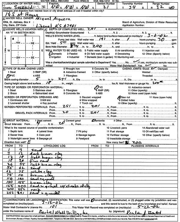
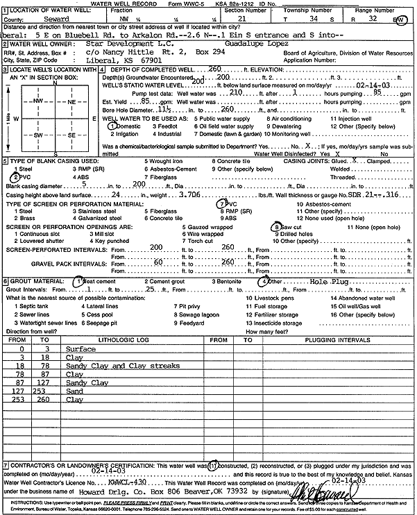
T34S, R32W, Sec. 21 NW NW NW |
Asquera, Miguel | 291 ft. | 50 gpm. | Domestic | Constructed | 12-Mar-2002 | Scan | ||
|
T34S, R32W, Sec. 21 SW NE SW NW |
Deleon, David | 306 ft. | 239 ft. | 50 gpm. | Domestic | Constructed | 12-Aug-2021 |
KOLAR |
|
|
T34S, R32W, Sec. 21 NW SW NW |
Garcia, Beatris | 287 ft. | 202 ft. | 50 gpm. | Domestic | Constructed | 24-Sep-2012 | ||
|
T34S, R32W, Sec. 21 NW NE NW |
Loya, Jacqueline | 340 ft. | 224 ft. | 30 gpm. | Domestic | Constructed | 14-Aug-2023 |
KOLAR |
|
|
T34S, R32W, Sec. 21 NE SW NW |
Rios, Abram | 302 ft. | 210 ft. | 50 gpm. | Domestic | Constructed | 14-Sep-2016 | ||
|
T34S, R32W, Sec. 21 NW NW NW |
Rios, Juan | 260 ft. | 210 ft. | 80 gpm. | Domestic | Constructed | 26-Jan-2006 | ||
|
T34S, R32W, Sec. 21 NE NW NE |
Rogland, Willie | 294 ft. | 212 ft. | 50 gpm. | Domestic | Constructed | 15-Nov-2004 | ||
|
T34S, R32W, Sec. 21 SW SW NW |
Sanchez, Jose | 303 ft. | 201 ft. | 50 gpm. | Domestic | Constructed | 02-Jul-2013 | ||
|
T34S, R32W, Sec. 21 NW SE NW |
Slawson Drilling Co. | 320 ft. | 185 ft. | 60 gpm. | Oil Field Water Supply | Constructed | 12-Dec-1985 | ||
|
T34S, R32W, Sec. 21 SW NE SE NW |
Star Development | 310 ft. | 190 ft. | 50 gpm. | Domestic | Constructed | 07-Aug-2009 | ||
|
T34S, R32W, Sec. 21 NE SW NW |
Star Development L.C. | 260 ft. | 204 ft. | 75 gpm. | Domestic | Constructed | 25-Nov-2005 | ||
|
T34S, R32W, Sec. 21 NE SW NW |
Star Development L.C. | 260 ft. | 212 ft. | 75 gpm. | Domestic | Constructed | 01-Dec-2005 | ||
|
T34S, R32W, Sec. 21 SW SW NW |
Star Development L.C. | 260 ft. | 204 ft. | 70 gpm. | Domestic | Constructed | 22-Mar-2005 | ||
|
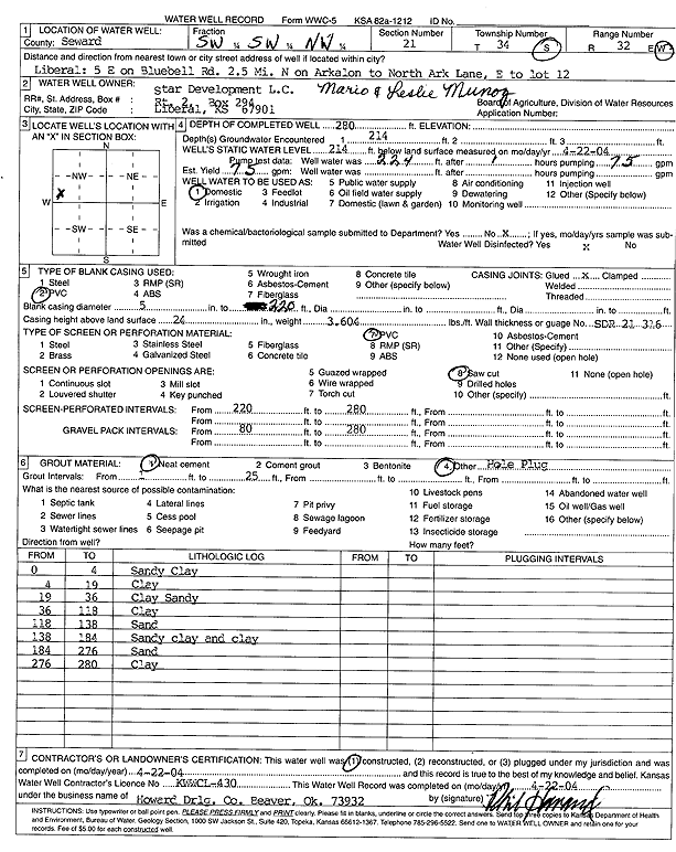
T34S, R32W, Sec. 21 SW SW NW |
Star Development L.C. | 280 ft. | 214 ft. | 75 gpm. | Domestic | Constructed | 22-Apr-2004 | Scan | |
|
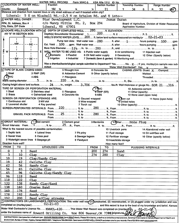
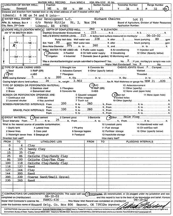
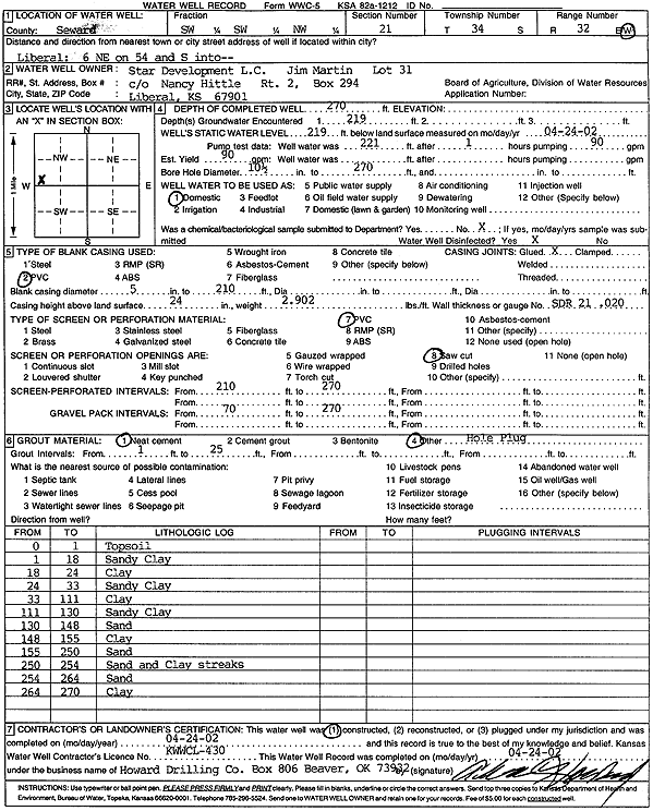
T34S, R32W, Sec. 21 NW |
Star Development L.C. | 280 ft. | 200 ft. | 100 gpm. | Domestic | Constructed | 21-Feb-2003 | Scan | |
|
T34S, R32W, Sec. 21 NE SW NW |
Star Development L.C. | 260 ft. | 215 ft. | 80 gpm. | Domestic | Constructed | 10-Jun-2002 | Scan | |
|
T34S, R32W, Sec. 21 SE SW NW |
Star Development L.C. | 260 ft. | 204 ft. | 90 gpm. | Domestic | Constructed | 25-Apr-2002 | Scan | |
|
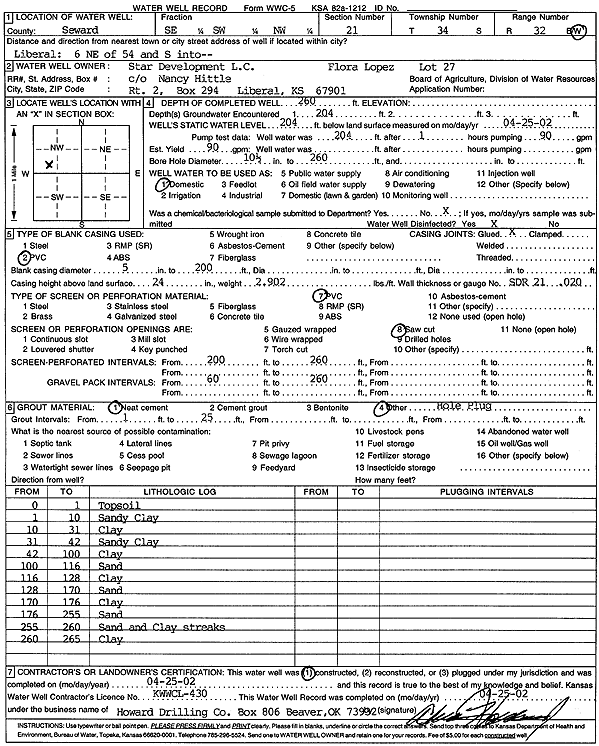
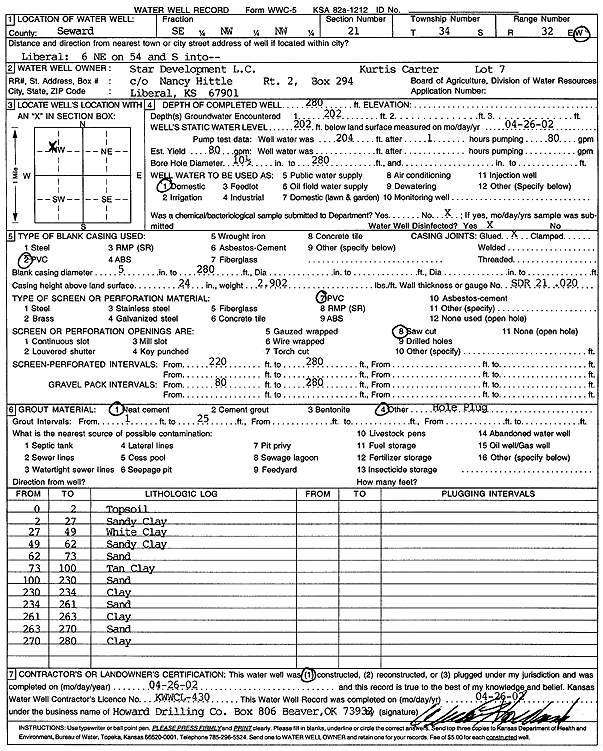
T34S, R32W, Sec. 21 NW |
Star Development L.C. | 260 ft. | 200 ft. | 85 gpm. | Domestic | Constructed | 14-Feb-2003 | Scan | |
|
T34S, R32W, Sec. 21 NE SW NW |
Star Development L.C. | 260 ft. | 200 ft. | 50 gpm. | Domestic | Constructed | 29-Nov-2005 | ||
|
T34S, R32W, Sec. 21 NW NW NW |
Star Development L.C. | 260 ft. | 205 ft. | 90 gpm. | Domestic | Constructed | 20-Aug-2005 | ||
|
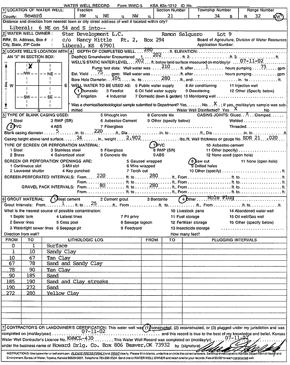
T34S, R32W, Sec. 21 NW NE NW |
Star Development L.C. | 280 ft. | 202 ft. | 75 gpm. | Domestic | Constructed | 11-Jul-2002 | Scan | |
|
T34S, R32W, Sec. 21 SW SW NW |
Star Development L.C. | 270 ft. | 219 ft. | 90 gpm. | Domestic | Constructed | 24-Apr-2002 | Scan | |
|
T34S, R32W, Sec. 21 NW NW NW |
Star Development, L.C. | 260 ft. | 200 ft. | 80 gpm. | Domestic | Constructed | 08-Aug-2005 | ||
|
T34S, R32W, Sec. 21 SE NW NW |
Star Development, L.C. | 280 ft. | 202 ft. | 80 gpm. | Domestic | Constructed | 26-Apr-2002 | Scan | |
|
T34S, R32W, Sec. 21 NE SW NW |
Star Development, L.C. | 260 ft. | 205 ft. | 75 gpm. | Domestic | Constructed | 16-Nov-2005 | ||
|
T34S, R32W, Sec. 22 C NW NE |
Davies, Adeline | 300 ft. | 182 ft. | 65 gpm. | Oil Field Water Supply | Constructed | 07-Apr-1982 | ||
|
T34S, R32W, Sec. 23 SW NW |
Ragland, John | 300 ft. | 181 ft. | 60 gpm. | Oil Field Water Supply | Adeline-Davies 1-23 | Constructed | 12-Nov-1982 | |
|
T34S, R32W, Sec. 23 C SW SW |
Slawson Drilling Co. | 280 ft. | 200 ft. | 75 gpm. | Oil Field Water Supply | Constructed | 27-Aug-1984 | ||
|
T34S, R32W, Sec. 24 E2 E2 SE |
Slawson Drilling Co. | 300 ft. | 190 ft. | Oil Field Water Supply | Constructed | 09-Jul-1984 | |||
|
T34S, R32W, Sec. 25 SW SE SW SW |
Lova, Manuel | 326 ft. | 210 ft. | 50 gpm. | Domestic | Constructed | 16-Nov-2007 | ||
|
T34S, R32W, Sec. 25 N2 NE SE |
Sage Drilling Co. | 300 ft. | 185 ft. | 60 gpm. | Oil Field Water Supply | Davies 1 | Constructed | 09-Jul-1981 | |
|
T34S, R32W, Sec. 25 NE SE SW |
Xplor Drilling Co. | 320 ft. | 198 ft. | 70 gpm. | Industrial | Queen 1 | Constructed | 22-Jun-1978 | |
|
T34S, R32W, Sec. 26 C NE |
Anadarko Production | 300 ft. | 183 ft. | 60 gpm. | Oil Field Water Supply | Nott A 1 | Constructed | 12-Sep-1980 | |
|
T34S, R32W, Sec. 27 SW SW NW |
Hittle, Wilma | 292 ft. | 215 ft. | 50 gpm. | Domestic | Constructed | 28-Nov-1994 | ||
|
T34S, R32W, Sec. 27 SW SW NW |
Hittle, Wilma | 292 ft. | 215 ft. | 50 gpm. | Domestic | Constructed | 28-Nov-1994 | ||
|
T34S, R32W, Sec. 27 C SE NE |
Inca Oil Co. | 280 ft. | 181 ft. | 60 gpm. | Oil Field Water Supply | Teagarden 1 | Constructed | 10-Sep-1981 | |
| View page: < Prev || 31 || 32 || 33 || 34 || 35 || 36 || 37 || 38 || 39 || 40 || Next > | |||||||||