Select location of well to view details.
Click on column heading to sort.
|
|
|
County: Sheridan Select location of well to view details. Click on column heading to sort. |
|
|
|
| View page: < Prev || 41 || 42 | |||||||||
| T-R-S | Owner | Well Depth Ascend. Desc. |
Static Water Level Ascend. Desc. |
Est. Yield Ascend. Desc. |
Well Use | Other ID | Action Taken | Completion Date Ascend. Desc. |
Scan? |
|
T10S, R30W, Sec. 22 NW NW NE |
Bixenman, Doug | 111 ft. | 27 ft. | 700 gpm. | Irrigation | Constructed | 16-Nov-2022 |
KOLAR |
|
|
T10S, R30W, Sec. 22 NW SE SE NE |
Bixenman, Doug | 130 ft. | 50 ft. | 50 gpm. | Oil Field Water Supply | Hawkeye 1-22 | Constructed | 29-Dec-2014 |
KOLAR |
|
T10S, R30W, Sec. 22 NW SE NE |
Bixenman, Doug | 112 ft. | 19 ft. | Domestic | Constructed | 27-Jan-2011 | |||
|
T10S, R30W, Sec. 22 SW NE NE |
Bixenman, William | 112 ft. | 25 ft. | 1000 gpm. | Irrigation | Constructed | 26-May-1976 | ||
|
T10S, R30W, Sec. 22 NW SE NW |
Fellhoelter, Robert | 124 ft. | 50 ft. | 10 gpm. | Domestic | Constructed | 23-Dec-1988 | ||
|
T10S, R30W, Sec. 23 SW SW SW |
Heir, Valentine | 120 ft. | 35 ft. | 50 gpm. | Domestic, Livestock | Constructed | 26-Jul-1986 | ||
|
T10S, R30W, Sec. 24 NW SE SE NW |
Mense Irrevocable Farm Trust | 140 ft. | 71 ft. | 50 gpm. | Oil Field Water Supply | Mense-Albers 1 | Constructed | 08-May-2015 |
KOLAR |
|
T10S, R30W, Sec. 25 NW NW NW |
Baalman, T. R. | 78 ft. | 20 ft. | 20 gpm. | Domestic | Constructed | 09-Apr-1990 | ||
|
T10S, R30W, Sec. 25 SE SW NE |
Baalman, Terrance | 68 ft. | Domestic | Plugged | 07-Dec-1989 | ||||
|
T10S, R30W, Sec. 25 SE NE NE |
Baalman, Terry | 94 ft. | 31 ft. | 20 gpm. | Domestic, Livestock | Constructed | 15-May-1979 | ||
|
T10S, R30W, Sec. 25 NW SE SW SW |
K and K Farms | 160 ft. | 50 gpm. | Oil Field Water Supply | Constructed | 09-Jan-2015 | |||
|
T10S, R30W, Sec. 25 SE NW SE |
Richmeier, Leo | 76 ft. | 60 ft. | Domestic, Livestock | Plugged | 31-Dec-2024 |
KOLAR |
||
|
T10S, R30W, Sec. 25 SE NW SE |
Richmeier, Leo | 100 ft. | 60 ft. | 20 gpm. | Domestic, Livestock | Constructed | 31-Dec-2024 |
KOLAR |
|
|
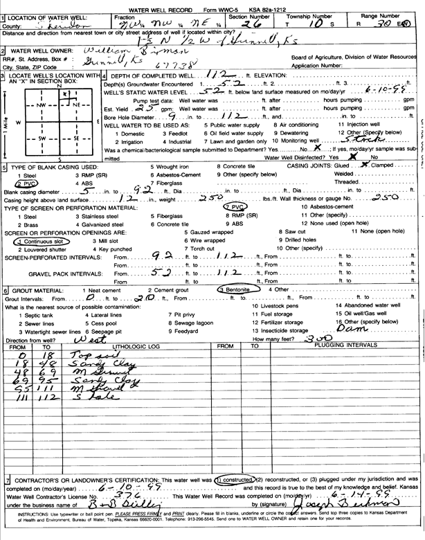
T10S, R30W, Sec. 26 NW NW NE |
Bixenman, William | 112 ft. | 52 ft. | 25 gpm. | Domestic, Livestock | Constructed | 10-Jun-1999 | Scan | |
|
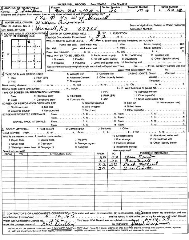
T10S, R30W, Sec. 26 NW NW NE |
Bixenman, William | 80 ft. | 52 ft. | (unstated)/abandoned | Plugged | 10-Jun-1999 | Scan | ||
|
T10S, R30W, Sec. 26 NW NW SW |
Bixenman, William H. and Harriett | Domestic | Plugged | 10-Nov-1990 | |||||
|
T10S, R30W, Sec. 27 NE SW SW |
Baalman, Urban N. | 186 ft. | 96 ft. | Domestic | Constructed | 27-Jun-1978 | |||
|
T10S, R30W, Sec. 28 NW NW NE |
Baalman, Urban | 176 ft. | 113 ft. | Domestic | Constructed | 03-Apr-1982 | |||
|
T10S, R30W, Sec. 28 SW SE NW |
Baalman, Urban and Ralph | 169 ft. | 100 ft. | Domestic | Plugged | 26-Jul-1989 | |||
|
T10S, R30W, Sec. 29 NE NW SE |
Felholter, Robert | 208 ft. | 110 ft. | 20 gpm. | Domestic, Livestock | Reconstructed | 01-Feb-2014 | ||
|
T10S, R30W, Sec. 30 SW NW SW |
Kansas Geological Survey | 106 ft. | 11.9 ft. | Monitoring well/observation/piezometer | Constructed | 30-Nov-1988 | Scan | ||
|
T10S, R30W, Sec. 30 SW NW SW |
Kansas Geological Survey | 106 ft. | 11.9 ft. | Monitoring well/observation/piezometer | Constructed | 30-Nov-1988 | Scan | ||
|
T10S, R30W, Sec. 30 SW NE NE |
Petrie, Retha | 80 ft. | 43 ft. | Domestic, Livestock | Constructed | 17-Jul-1978 | |||
|
T10S, R30W, Sec. 31 SW NW NE |
Beckman, Durwood | 144 ft. | 80 ft. | 100 gpm. | Domestic | Constructed | 01-Jan-1985 | ||
|
T10S, R30W, Sec. 31 NW NE NW |
Beckman, Joseph G. | 156 ft. | 80 ft. | 20 gpm. | Domestic, Livestock | Constructed | 04-Apr-1987 | ||
|
T10S, R30W, Sec. 32 SW SW NW |
Baalman, Harold | 210 ft. | 121 ft. | Oil Field Water Supply | Constructed | 10-Jan-1989 | |||
|
T10S, R30W, Sec. 32 SW NE NE |
Baalman, Harold | 208 ft. | 110 ft. | 25 gpm. | Domestic | Constructed | 01-Mar-1988 | ||
|
T10S, R30W, Sec. 32 SE SE SE |
Baalman, Janice | 122 ft. | 75 ft. | 10 gpm. | Domestic | Constructed | 08-Feb-1990 | ||
|
T10S, R30W, Sec. 34 NW SW NW |
Rueschhoff, David | 180 ft. | 118 ft. | Oil Field Water Supply | Plugged | 20-Jun-1991 | |||
|
T10S, R30W, Sec. 34 NW SW NW |
Rueschhoff, David | 180 ft. | Oil Field Water Supply | Constructed | 20-Jun-1991 | ||||
|
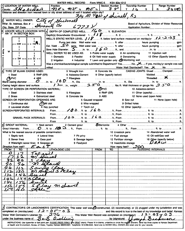
T10S, R30W, Sec. 35 NE SW NE |
City of Grinnell | 164 ft. | 111 ft. | Public Water Supply | Well 2 (TH 1-82) | Constructed | 18-Aug-1982 | ||
|
T10S, R30W, Sec. 35 NE NE NE |
City of Grinnell | 160 ft. | 118 ft. | 50 gpm. | Monitoring well/observation/piezometer | Constructed | 05-Dec-2003 | Scan | |
|
T10S, R30W, Sec. 36 SW SW SW |
City of Grinnell | 150 ft. | 100 ft. | Public Water Supply | Plugged | 21-Apr-1986 | |||
|
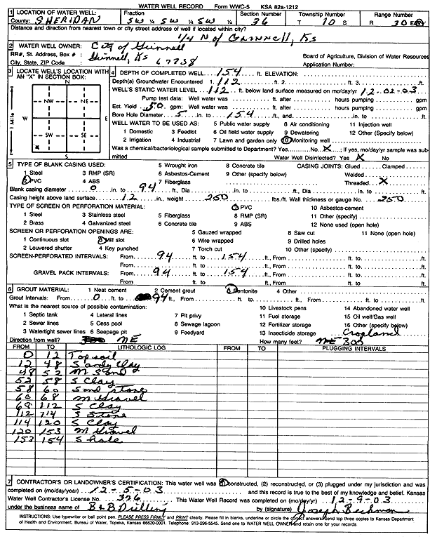
T10S, R30W, Sec. 36 SW SW SW |
City of Grinnell | 154 ft. | 112 ft. | 50 gpm. | Monitoring well/observation/piezometer | Constructed | 05-Dec-2003 | Scan | |
|
T10S, R30W, Sec. 36 SW SW NE |
Holdforth, Kenneth | 100 ft. | Domestic | Plugged | 15-Apr-1990 | ||||
| View page: < Prev || 41 || 42 | |||||||||