Select location of well to view details.
Click on column heading to sort.
|
|
|
County: Stanton Select location of well to view details. Click on column heading to sort. |
|
|
|
| View page: < Prev || 11 || 12 || 13 || 14 || 15 || 16 || 17 || 18 || 19 || 20 || Next > | |||||||||
| T-R-S | Owner | Well Depth Ascend. Desc. |
Static Water Level Ascend. Desc. |
Est. Yield Ascend. Desc. |
Well Use | Other ID | Action Taken | Completion Date Ascend. Desc. |
Scan? |
|
T29S, R41W, Sec. 25 SW NE SW SW |
Morris, Randy | 440 ft. | 280 ft. | 15 gpm. | Domestic, Livestock | Constructed | 25-Oct-2012 |
KOLAR |
|
|
T29S, R41W, Sec. 26 SW SW SW SW |
Garcia, Cesar | 488 ft. | 244 ft. | 20 gpm. | Domestic, Livestock | Constructed | 11-Sep-2019 | ||
|
T29S, R41W, Sec. 26 C NW SW |
H-30 Drilling, Inc. | 240 ft. | 175 ft. | 75 gpm. | Oil Field Water Supply | Constructed | 13-Aug-1989 | ||
|
T29S, R41W, Sec. 26 SW SE NW |
Murfin Drilling | 240 ft. | 176 ft. | 95 gpm. | Oil Field Water Supply | Pro Farms 26-1 | Constructed | 01-May-1992 | |
|
T29S, R41W, Sec. 27 NW NE SW |
H-30 Drilling, Inc. | 380 ft. | 200 ft. | 30 gpm. | Oil Field Water Supply | Constructed | 12-Oct-1989 | ||
|
T29S, R41W, Sec. 27 SE NE NE SE |
Terin, Jesus | 480 ft. | 278 ft. | 30 gpm. | Domestic, Livestock | Constructed | 24-Jul-2019 | ||
|
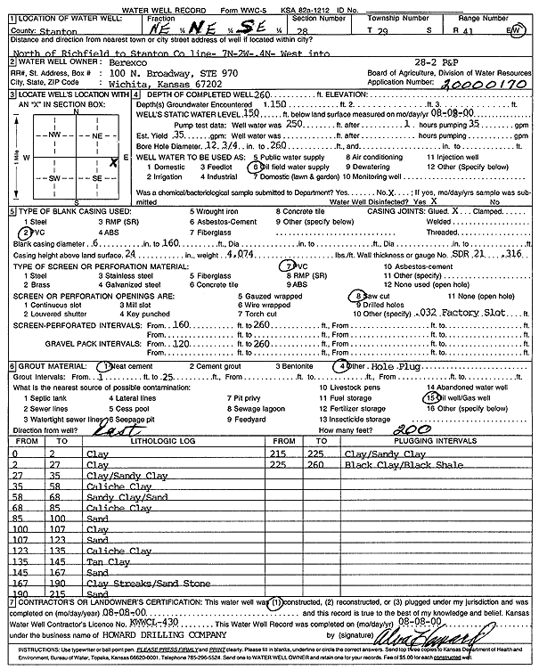
T29S, R41W, Sec. 28 NE NE SE |
Berexco Inc. | 260 ft. | 150 ft. | 35 gpm. | Oil Field Water Supply | P and P 28-2 | Constructed | 08-Aug-2000 | Scan |
|
T29S, R41W, Sec. 28 SE SW SW |
Cockreham, Olie | 352 ft. | 205 ft. | 700 gpm. | Irrigation | Constructed | 28-May-1975 | ||
|
T29S, R41W, Sec. 28 E2 NE NW |
Murfin Drilling | 380 ft. | 165 ft. | 40 gpm. | Oil Field Water Supply | Berkoz 28-1 | Constructed | 13-Mar-1992 | |
|
T29S, R41W, Sec. 29 NE NE SE |
Petroleum, Inc. | 260 ft. | 180 ft. | 30 gpm. | Oil Field Water Supply | Spikes 1-29 | Constructed | 09-Aug-1993 | |
|
T29S, R41W, Sec. 31 NE NW SE |
Wilkerson, Bryce | 623 ft. | 254 ft. | 115 gpm. | Irrigation | Constructed | 29-Mar-2023 |
KOLAR |
|
|
T29S, R41W, Sec. 34 NW NW NW |
Cockreham, Olie | 504.5 ft. | 195 ft. | 375 gpm. | Irrigation | Constructed | 12-Jun-1975 | ||
|
T29S, R41W, Sec. 35 NE NE SE |
Moreno, Porfirio | 380 ft. | 275 ft. | 12 gpm. | Domestic, Livestock | Constructed | 09-Nov-2023 |
KOLAR |
|
|
T29S, R42W, Sec. 2 SW NW NW |
Wartman, Greg | 150 ft. | 120 ft. | Domestic | Plugged | 28-Oct-2011 | |||
|
T29S, R42W, Sec. 2 SW NW NW |
Wartman, Greg | 475 ft. | Domestic | Constructed | 06-Jun-2011 | ||||
|
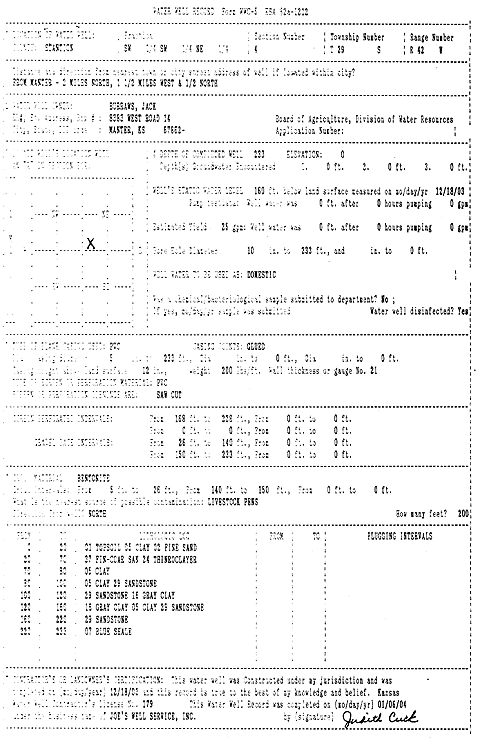
T29S, R42W, Sec. 4 SW SW NE |
Burraws, Jack | 233 ft. | 160 ft. | 25 gpm. | Domestic | Constructed | 18-Dec-2003 | Scan | |
|
T29S, R42W, Sec. 4 SW SW NE |
Elder, Royce | 50 ft. | 17 ft. | Irrigation | Constructed | 22-Apr-1985 | |||
|
T29S, R42W, Sec. 4 SE NW SE |
Harril Oil and Gas | 245 ft. | 45 ft. | 100 gpm. | Oil Field Water Supply | Kilgor-Carrither 1-4 | Constructed | 19-Sep-1996 | |
|
T29S, R42W, Sec. 4 SW SW NE |
Steimel, Chris | 87 ft. | 22 ft. | 20 gpm. | Domestic | Constructed | 19-Oct-1989 | ||
|
T29S, R42W, Sec. 5 SW NE SE |
Berexco Inc. | 80 ft. | 25 ft. | 150 gpm. | Oil Field Water Supply | Constructed | 05-Jun-1986 | ||
|
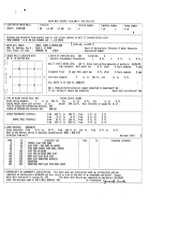
T29S, R42W, Sec. 5 NE SW NW |
Jerry Jones and Ron Grover | 285 ft. | 148 ft. | 35 gpm. | Other | Constructed | 04-Jun-1998 | Scan | |
|
T29S, R42W, Sec. 6 NW NW NE |
Wilkerson, Burford | 277 ft. | 190 ft. | 35 gpm. | Domestic | Constructed | 05-Dec-2000 | Scan | |
|
T29S, R42W, Sec. 7 NW NE SE |
McKee and Young Trust | 460 ft. | 238 ft. | 25 gpm. | Domestic, Livestock | Constructed | 11-Jul-2025 |
KOLAR |
|
|
T29S, R42W, Sec. 11 NE SW SE |
Nairn, Archie | 414 ft. | 229 ft. | 40 gpm. | Domestic | Constructed | 06-Feb-2001 | Scan | |
|
T29S, R42W, Sec. 11 NE SW SE |
Walton, Jason | 400 ft. | 233 ft. | 30 gpm. | Domestic, Livestock | Constructed | 15-May-2025 |
KOLAR |
|
|
T29S, R42W, Sec. 14 SE NW SW |
City of Manter | 258 ft. | 226 ft. | Public Water Supply | Plugged | 11-Mar-1992 | |||
|
T29S, R42W, Sec. 14 SE NW SW |
City of Manter | 235 ft. | 226 ft. | Public Water Supply | Plugged | 05-Mar-1992 | |||
|
T29S, R42W, Sec. 14 SE SE SW |
City of Manter | 603 ft. | 236 ft. | 300 gpm. | Public Water Supply | Constructed | 12-Sep-1975 | ||
|
T29S, R42W, Sec. 14 NW SW SW |
Collingwood Grain, Inc. | 88 ft. | 76.11 ft. | Monitoring well/observation/piezometer | MW 6 | Constructed | 20-Jun-1995 | ||
|
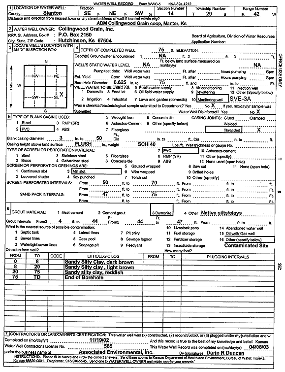
T29S, R42W, Sec. 14 SE NE SW |
Collingwood Grain, Inc. | 75 ft. | Environmental Remediation, Soil Vapor Extraction | SVE 3A | Constructed | 19-Nov-2002 | Scan | ||
|
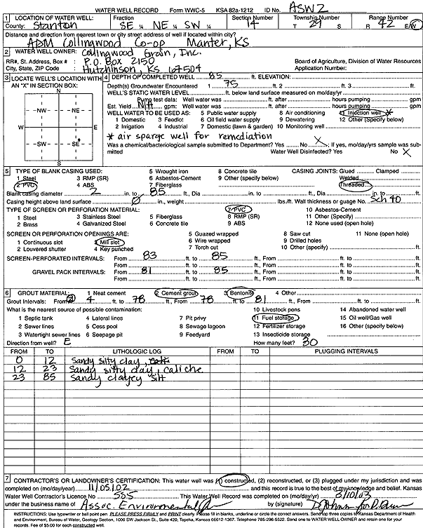
T29S, R42W, Sec. 14 SE NE SW |
Collingwood Grain, Inc. | 85 ft. | 75 ft. | Environmental Remediation, Air Sparge | ASW 1 | Constructed | 06-Nov-2002 | Scan | |
|
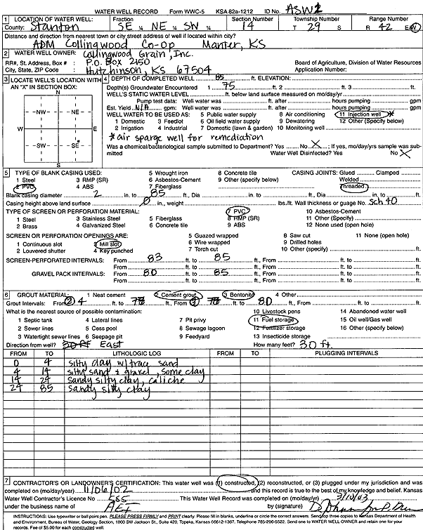
T29S, R42W, Sec. 14 SE NE SW |
Collingwood Grain, Inc. | 85 ft. | 75 ft. | Environmental Remediation, Air Sparge | ASW 2 | Constructed | 05-Nov-2002 | Scan | |
|
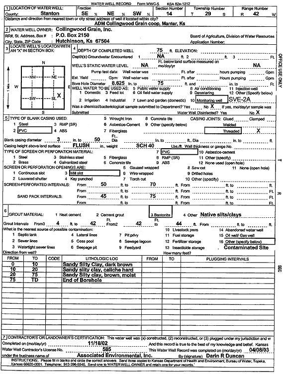
T29S, R42W, Sec. 14 SE NE SW |
Collingwood Grain, Inc. | 75 ft. | Environmental Remediation, Soil Vapor Extraction | SVE 2A | Constructed | 18-Nov-2002 | Scan | ||
|
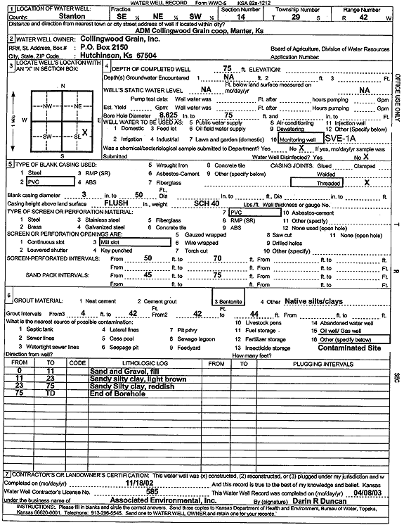
T29S, R42W, Sec. 14 SE NE SW |
Collingwood Grain, Inc. | 75 ft. | Environmental Remediation, Soil Vapor Extraction | SVE 1A | Constructed | 18-Nov-2002 | Scan | ||
|
T29S, R42W, Sec. 14 SW SW SW |
Collingwood Grain, Inc. | 90 ft. | 75.75 ft. | Monitoring well/observation/piezometer | MW 1 | Constructed | 01-Jun-1995 | ||
|
T29S, R42W, Sec. 14 NW SW SW |
Collingwood Grain, Inc. | 90 ft. | 77.04 ft. | Monitoring well/observation/piezometer | MW 4 | Constructed | 07-Jun-1995 | ||
|
T29S, R42W, Sec. 14 NW SW SW |
Collingwood Grain, Inc. | 90 ft. | 76.35 ft. | Monitoring well/observation/piezometer | MW 2 | Constructed | 03-Jun-1995 | ||
|
T29S, R42W, Sec. 14 NW SW SW |
Collingwood Grain, Inc. | 90 ft. | 76.44 ft. | Monitoring well/observation/piezometer | MW 5 | Constructed | 09-Jun-1995 | ||
|
T29S, R42W, Sec. 14 NW SW SW |
Collingwood Grain, Inc. | 90 ft. | 75.12 ft. | Monitoring well/observation/piezometer | MW 3 | Constructed | 05-Jun-1995 | ||
|
T29S, R42W, Sec. 14 NE SW SW |
Heyen, Madean | 312 ft. | 154 ft. | Domestic | Constructed | 15-Jan-1987 | |||
|
T29S, R42W, Sec. 14 NE SE SW |
Johnson Coop Grain | 85.1 ft. | Environmental Remediation, Air Sparge | ASW 3 J | Plugged | 02-Sep-2009 | |||
|
T29S, R42W, Sec. 14 SE SW SW |
Johnson Coop Grain | 83.3 ft. | Environmental Remediation, Air Sparge | ASW | Plugged | 02-Sep-2009 | |||
|
T29S, R42W, Sec. 14 NW SE SW |
Johnson Coop Grain | 89 ft. | 75.27 ft. | Monitoring well/observation/piezometer | MW 16 | Constructed | 06-Dec-1996 | ||
|
T29S, R42W, Sec. 14 SW SW SW |
Johnson Coop Grain | 85 ft. | Monitoring well/observation/piezometer | MW 20 | Constructed | 24-Nov-1997 | |||
|
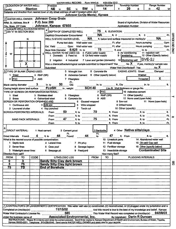
T29S, R42W, Sec. 14 NE SE SW |
Johnson Coop Grain | 75 ft. | Environmental Remediation, Soil Vapor Extraction | SVE 2J | Constructed | 15-Nov-2002 | Scan | ||
|
T29S, R42W, Sec. 14 SE SW SW |
Johnson Coop Grain | 85 ft. | Monitoring well/observation/piezometer | MW 26 | Constructed | 14-Jul-1998 | |||
|
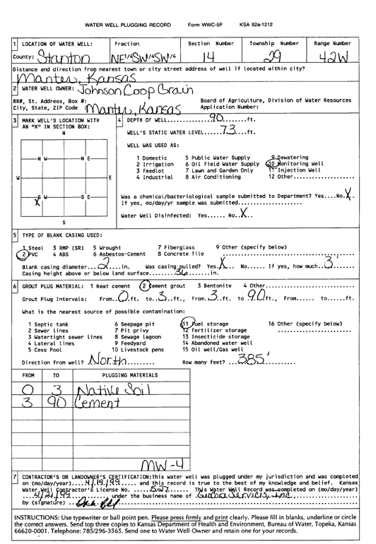
T29S, R42W, Sec. 14 NE SW SW |
Johnson Coop Grain | 90 ft. | 73 ft. | Monitoring well/observation/piezometer | MW 4 | Plugged | 19-Apr-1999 | Scan | |
|
T29S, R42W, Sec. 14 NW SE SW |
Johnson Coop Grain | 86 ft. | 75 ft. | Monitoring well/observation/piezometer | MW 16 | Plugged | 19-Apr-1999 | Scan | |
|
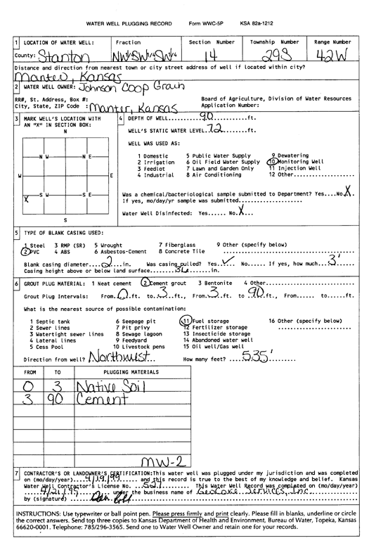
T29S, R42W, Sec. 14 NW SW SW |
Johnson Coop Grain | 90 ft. | 72 ft. | Monitoring well/observation/piezometer | MW 2 | Plugged | 19-Apr-1999 | Scan | |
|
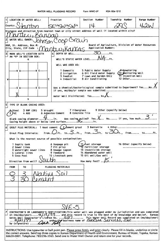
T29S, R42W, Sec. 14 SE SW SW |
Johnson Coop Grain | 30 ft. | Monitoring well/observation/piezometer | SVE 5 | Plugged | 19-Apr-1999 | Scan | ||
| View page: < Prev || 11 || 12 || 13 || 14 || 15 || 16 || 17 || 18 || 19 || 20 || Next > | |||||||||