Select location of well to view details.
Click on column heading to sort.
|
|
|
County: Stevens Select location of well to view details. Click on column heading to sort. |
|
|
|
| View page: < Prev || 11 || 12 || 13 || 14 || 15 || 16 || 17 || 18 || 19 || 20 || Next > | |||||||||
| T-R-S | Owner | Well Depth Ascend. Desc. |
Static Water Level Ascend. Desc. |
Est. Yield Ascend. Desc. |
Well Use | Other ID | Action Taken | Completion Date Ascend. Desc. |
Scan? |
|
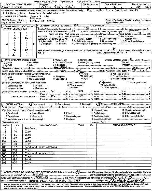
T32S, R38W, Sec. 5 SE SW SW |
Hittle, Steve | 380 ft. | 168 ft. | Domestic | Constructed | 24-May-2004 | Scan | ||
|
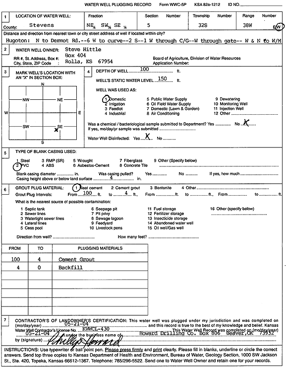
T32S, R38W, Sec. 5 NE SW SE |
Hittle, Steve | 100 ft. | 150 ft. | Domestic | Plugged | 21-May-2004 | Scan | ||
|
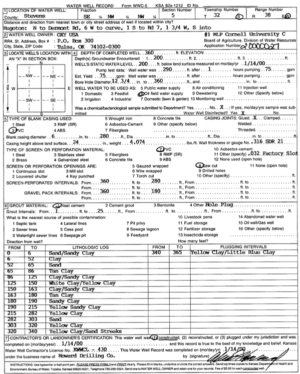
T32S, R38W, Sec. 5 SE NW NW |
Oxy USA, Inc. | 360 ft. | 200 ft. | 75 gpm. | Oil Field Water Supply | MLP Cornell Univ C-1 | Constructed | 14-Jan-2000 | Scan |
|
T32S, R38W, Sec. 6 SW SE SE |
Anadarko Petroleum Corp. | 240 ft. | 90 ft. | 60 gpm. | Oil Field Water Supply | Constructed | 22-Oct-1976 | ||
|
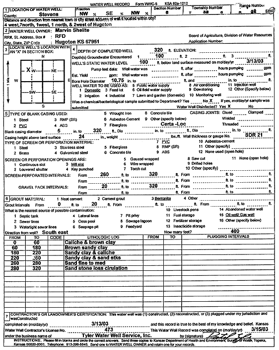
T32S, R38W, Sec. 6 NW SE NW |
Shelite, Marvin | 320 ft. | 100 ft. | Domestic | Constructed | 13-Mar-2003 | Scan | ||
|
T32S, R38W, Sec. 7 C SE |
Gabbert and Jones | 275 ft. | 100 ft. | 60 gpm. | Oil Field Water Supply | Youngren H | Constructed | 07-May-1987 | |
|
T32S, R38W, Sec. 7 SW NW SW |
Mesa Limited Partnership | 323 ft. | 90 ft. | 75 gpm. | Oil Field Water Supply | Constructed | 28-Feb-1987 | ||
|
T32S, R38W, Sec. 7 SW SW NE |
Schmidt, Dixie | 260 ft. | 90 ft. | Domestic | Constructed | 18-Apr-1982 | |||
|
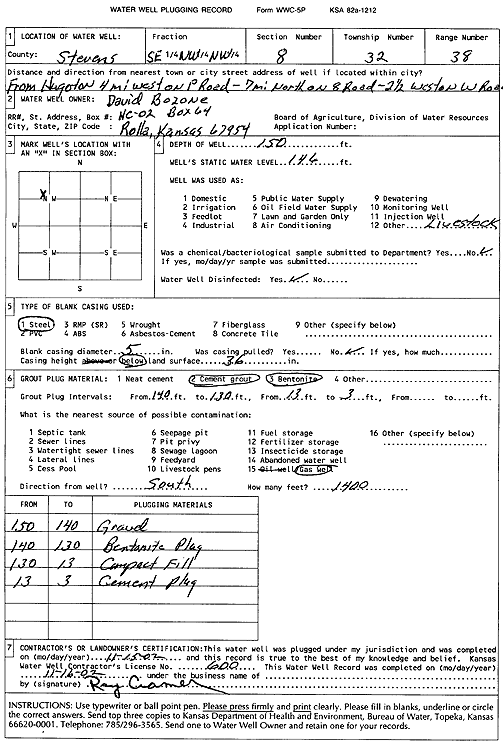
T32S, R38W, Sec. 8 SE NW NW |
Bozone, David | 150 ft. | 146 ft. | Domestic, Livestock | Plugged | 15-Nov-2002 | Scan | ||
|
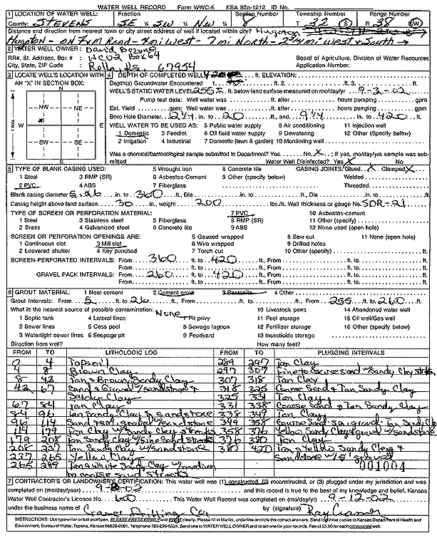
T32S, R38W, Sec. 8 SE SW NW |
Bozone, David | 420 ft. | 255 ft. | Domestic | Constructed | 03-Sep-2002 | Scan | ||
|
T32S, R38W, Sec. 10 SE SE SE |
Hittle, Bob | 510 ft. | 132 ft. | 20 gpm. | Domestic | Constructed | 08-Oct-1988 | ||
|
T32S, R38W, Sec. 11 SW NW SE |
Anadarko Petroleum Corp. | 230 ft. | 144 ft. | Oil Field Water Supply | Crump 1-11 | Plugged | 23-Jan-1997 | ||
|
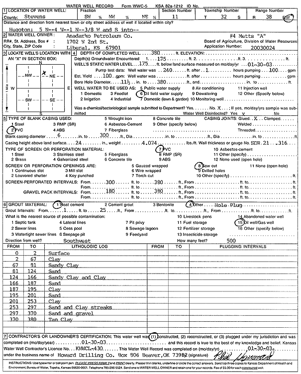
T32S, R38W, Sec. 11 SW NW NE |
Anadarko Petroleum Corp. | 380 ft. | 175 ft. | 100 gpm. | Oil Field Water Supply | Metts A-4 | Constructed | 30-Jan-2003 | Scan |
|
T32S, R38W, Sec. 11 NW NW SW |
Hittle, Walter | 475 ft. | 147 ft. | 1000 gpm. | Irrigation | Constructed | 03-Nov-1976 | ||
|
T32S, R38W, Sec. 11 NE NE NE |
Quimby, Hobart | 340 ft. | 140 ft. | 20 gpm. | Domestic | Constructed | 04-Mar-1981 | ||
|
T32S, R38W, Sec. 12 NW SE SE |
Gabbert and Jones | 280 ft. | 147 ft. | 50 gpm. | Oil Field Water Supply | Metts A-2 | Constructed | 31-May-1989 | |
|
T32S, R38W, Sec. 12 NW NW NE |
Hittle, Bobby J. | 320 ft. | 135 ft. | 30 gpm. | Domestic | Constructed | 31-Aug-1979 | ||
|
T32S, R38W, Sec. 13 NW SE SW |
Keefer Farms | 540 ft. | 282 ft. | 1248 gpm. | Irrigation | Constructed | 11-Sep-1976 | ||
|
T32S, R38W, Sec. 13 C SW |
Keefer Farms | 533 ft. | 160 ft. | 1320 gpm. | Irrigation | Well 1 | Constructed | 11-Apr-1975 | |
|
T32S, R38W, Sec. 13 NE NE SW |
Keefer Farms | 562 ft. | 116 ft. | 1279 gpm. | Irrigation | Constructed | 02-Dec-1975 | ||
|
T32S, R38W, Sec. 13 NE NE SW |
United Pentecostal Church | 550 ft. | 189 ft. | Irrigation | Reconstructed | 14-Dec-1995 | |||
|
T32S, R38W, Sec. 14 NW NW SW SW |
Bar G Ranch | 506 ft. | 255 ft. | 1409 gpm. | Irrigation | Constructed | 27-Jan-2017 |
KOLAR |
|
|
T32S, R38W, Sec. 14 SW SW SE |
Keefer Farms | 463 ft. | 150 ft. | 925 gpm. | Irrigation | Well 4 | Constructed | 31-Mar-1975 | |
|
T32S, R38W, Sec. 14 C NW |
Keefer Farms | 548 ft. | 120 ft. | 1200 gpm. | Irrigation | Well 3 | Constructed | 02-Apr-1975 | |
|
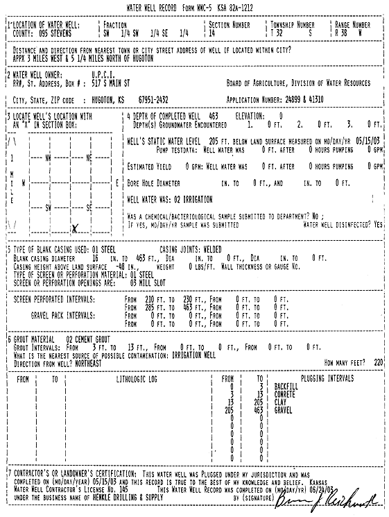
T32S, R38W, Sec. 14 SW SW SE |
Kuharic, Jim | 500 ft. | 192 ft. | Irrigation | Constructed | 12-Mar-2003 | Scan | ||
|
T32S, R38W, Sec. 14 NE NW NE |
Mobil Oil Corp./Edith Quimby | 400 ft. | 123 ft. | 100 gpm. | Oil Field Water Supply | Republic Fee 1 Unit 3 | Constructed | 09-Aug-1988 | |
|
T32S, R38W, Sec. 14 SW SW SE |
United Pentecostal Church | 463 ft. | 205 ft. | Irrigation | Plugged | 15-May-2003 | Scan | ||
|
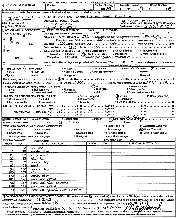
T32S, R38W, Sec. 15 SW NW NW |
Anadarko Petroleum Corp. | 360 ft. | 220 ft. | 100 gpm. | Oil Field Water Supply | Ponder HJV A2 | Constructed | 22-Jun-2003 | Scan |
|
T32S, R38W, Sec. 15 SE NE NE |
Hittle, Walter | 473 ft. | 192 ft. | 70 gpm. | Domestic, Livestock | Constructed | 12-Oct-1998 | ||
|
T32S, R38W, Sec. 17 NE NW NE |
Schmidt, Dixie Y. | 205 ft. | 85 ft. | Domestic | Constructed | 16-Apr-1982 | |||
|
T32S, R38W, Sec. 18 SW SW SE NE |
Hull, Gerald | 130 ft. | 90 ft. | Domestic, Livestock | Plugged | 12-Dec-2019 | |||
|
T32S, R38W, Sec. 18 NE SW SW NE |
Hull, Jerry | 380 ft. | 168 ft. | 50 gpm. | Domestic, Livestock | Constructed | 01-Jun-2019 | ||
|
T32S, R38W, Sec. 18 SE SE SE |
Leininger, Chuck | 385 ft. | 143 ft. | 50 gpm. | Domestic, Livestock | Constructed | 28-Jun-2023 |
KOLAR |
|
|
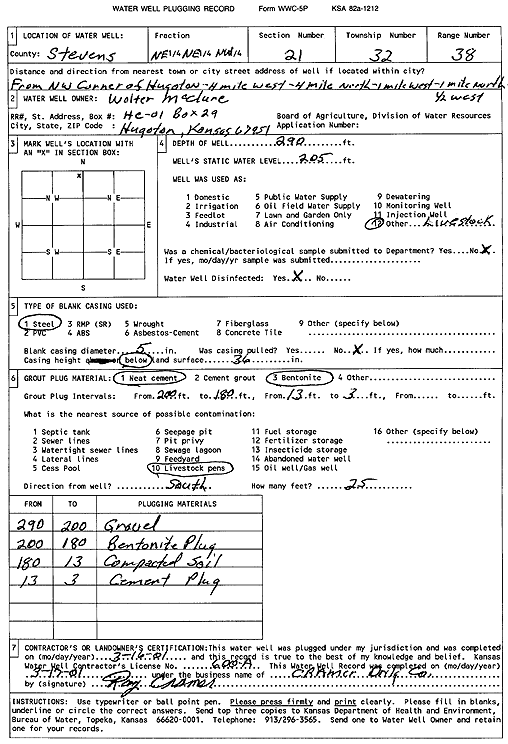
T32S, R38W, Sec. 21 NE NE NW |
McClure, Walter | 290 ft. | 205 ft. | Domestic, Livestock | Plugged | 16-Mar-2001 | Scan | ||
|
T32S, R38W, Sec. 21 NE NW SE SE |
Persinger, Jim | 425 ft. | 143 ft. | 50 gpm. | Domestic, Livestock | Constructed | 20-Jul-2021 |
KOLAR |
|
|
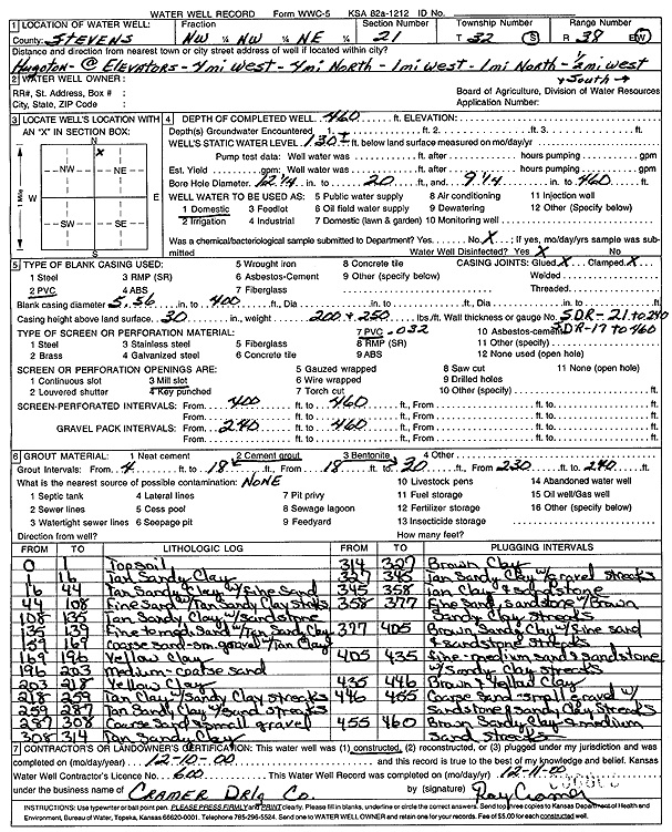
T32S, R38W, Sec. 21 NW NW NE |
unknown | 460 ft. | 130 ft. | Domestic | Constructed | 10-Dec-2000 | Scan | ||
|
T32S, R38W, Sec. 22 NE NE NE |
Hoskinson, Dick | 325 ft. | 150 ft. | Domestic | Constructed | 16-Mar-1989 | |||
|
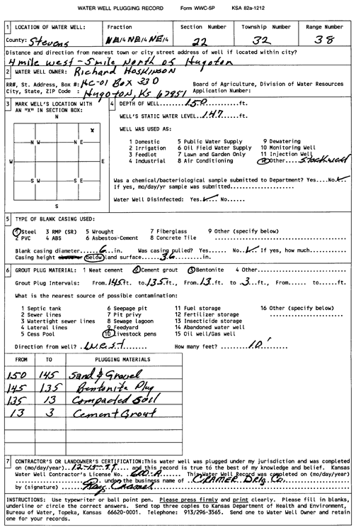
T32S, R38W, Sec. 22 NE NE NE |
Hoskinson, Richard | 150 ft. | 147 ft. | Domestic, Livestock | Plugged | 15-Dec-1999 | Scan | ||
|
T32S, R38W, Sec. 23 C NW |
Anadarko Petroleum Corp. | 240 ft. | 168 ft. | Oil Field Water Supply | Speakman 1-23 | Plugged | 23-Jan-1997 | ||
|
T32S, R38W, Sec. 23 C SW SE |
Nordling, Bernard | 280 ft. | 162 ft. | 60 gpm. | Oil Field Water Supply | Constructed | 04-Jun-1982 | ||
|
T32S, R38W, Sec. 24 C NE |
Keefer Farms | 555 ft. | 121 ft. | 1200 gpm. | Irrigation | Well 2 | Constructed | 28-Mar-1975 | |
|
T32S, R38W, Sec. 24 S2 S2 NE |
Lanex Drilling/Walter Beasley | 320 ft. | 126 ft. | 60 gpm. | Oil Field Water Supply | Davis Western 1 | Constructed | 11-Mar-1984 | |
|
T32S, R38W, Sec. 24 S2 S2 NE |
Lanex Drilling/Walter Beasley | 320 ft. | 126 ft. | 60 gpm. | Oil Field Water Supply | Davis Western 1 | Plugged | 25-Feb-1984 | |
|
T32S, R38W, Sec. 24 NE NE SE |
Passmore, Bob | 500 ft. | 190 ft. | Irrigation | Reconstructed | 30-Sep-1997 | |||
|
T32S, R38W, Sec. 25 SW SW SW |
Hill, Jerry | 533 ft. | Domestic | Constructed | 30-Dec-2008 | ||||
|
T32S, R38W, Sec. 25 NW NW NE |
Walker, Robert | 328 ft. | 160 ft. | Domestic | Constructed | 11-Jul-1992 | |||
|
T32S, R38W, Sec. 26 W2 NW |
Keefer Farms | 500 ft. | 129 ft. | 1275 gpm. | Irrigation | Well 5 | Constructed | 03-Apr-1975 | |
|
T32S, R38W, Sec. 26 NW SW SW |
Mobil Oil Corp./Warren Moon | 320 ft. | 152 ft. | Oil Field Water Supply | Warren Moon 1 | Constructed | 26-Jul-1989 | ||
|
T32S, R38W, Sec. 26 NW SW SW |
Moon, Aletha and Lloyd | 204 ft. | 200 ft. | Domestic | Plugged | 23-Jan-2006 | |||
|
T32S, R38W, Sec. 26 SW NE SE |
Ratcliff, Charles M. | 220 ft. | 134 ft. | 150 gpm. | Domestic, Livestock | Constructed | 02-Jun-1977 | ||
| View page: < Prev || 11 || 12 || 13 || 14 || 15 || 16 || 17 || 18 || 19 || 20 || Next > | |||||||||