Select location of well to view details.
Click on column heading to sort.
|
|
|
County: Stevens Select location of well to view details. Click on column heading to sort. |
|
|
|
| View page: < Prev || 21 || 22 || 23 || 24 || 25 || 26 || 27 || 28 || 29 || 30 || Next > | |||||||||
| T-R-S | Owner | Well Depth Ascend. Desc. |
Static Water Level Ascend. Desc. |
Est. Yield Ascend. Desc. |
Well Use | Other ID | Action Taken | Completion Date Ascend. Desc. |
Scan? |
|
T33S, R35W, Sec. 11 NE NE SW SW |
Baeza, Servando | 185 ft. | Domestic, Livestock | Plugged | 13-Feb-2015 | ||||
|
T33S, R35W, Sec. 11 SE SE SE |
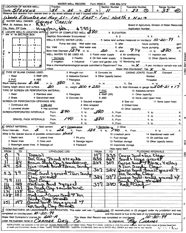
Carlile, George | 380 ft. | Domestic | Constructed | 20-Oct-1999 | Scan | |||
|
T33S, R35W, Sec. 11 C SW NW |
Hugoton Energy | 360 ft. | 175 ft. | 150 gpm. | Oil Field Water Supply | Alderman 2-11 | Constructed | 04-May-1994 | |
|
T33S, R35W, Sec. 11 SW SW SW |
Mobil Oil Corp./Dale Horton | 340 ft. | 123 ft. | 100 gpm. | Oil Field Water Supply | Alderman Unit 2 | Constructed | 18-Dec-1986 | |
|
T33S, R35W, Sec. 11 SW SW NW |
Sandoval, Chris | 340 ft. | 127 ft. | 20 gpm. | Domestic | Constructed | 25-Sep-1989 | ||
|
T33S, R35W, Sec. 11 NW NW NW |
Van Douge, Don | 288 ft. | 95 ft. | Domestic | Constructed | 01-Dec-1977 | |||
|
T33S, R35W, Sec. 12 SE SE SE |
Cline Farms | 500 ft. | 275 ft. | 90 gpm. | Domestic | Constructed | 16-May-2011 | ||
|
T33S, R35W, Sec. 12 SW SE SE |
Cline, Chester | 334 ft. | 139 ft. | 50 gpm. | Domestic | Constructed | 30-Nov-1979 | ||
|
T33S, R35W, Sec. 12 SW SE SE |
Cline, Chester | 248 ft. | 155 ft. | 30 gpm. | Domestic | Reconstructed | 01-Nov-1985 | ||
|
T33S, R35W, Sec. 12 SW SW NW |
Cline, Roger | 535 ft. | 160 ft. | Irrigation | Constructed | 03-Jul-1989 | |||
|
T33S, R35W, Sec. 13 NW SW SW |
Arco Oil and Gas/Terry Campbell | 350 ft. | 140 ft. | 75 gpm. | Oil Field Water Supply | Campbell 1 A-2 | Constructed | 11-Dec-1986 | |
|
T33S, R35W, Sec. 13 NE NE SW |
Armitage Farms | 569 ft. | 298 ft. | Irrigation | Constructed | 17-Dec-2025 |
KOLAR |
||
|
T33S, R35W, Sec. 13 C SW NW |
Campbell, Burgis | 407 ft. | 173 ft. | 50 gpm. | Domestic | Constructed | 30-Jul-1985 | ||
|
T33S, R35W, Sec. 14 SW SW SW |
Cargill, Inc. | 285 ft. | 223 ft. | Monitoring well/observation/piezometer | MW 1 | Constructed | |||
|
T33S, R35W, Sec. 14 SW SW SW |
Cargill, Inc. | 310 ft. | 132 ft. | Monitoring well/observation/piezometer | MW W | Plugged | 22-Oct-2025 |
KOLAR |
|
|
T33S, R35W, Sec. 14 SW SW SW |
Cargill, Inc. | 310 ft. | 198.8 ft. | Monitoring well/observation/piezometer | MW SE | Plugged | 22-Oct-2025 |
KOLAR |
|
|
T33S, R35W, Sec. 14 SW SW SW |
Cargill, Inc. | 310 ft. | 218.8 ft. | Monitoring well/observation/piezometer | MW NE | Plugged | 22-Oct-2025 |
KOLAR |
|
|
T33S, R35W, Sec. 14 SW SW SW |
Cargill, Inc. | 340 ft. | 223 ft. | Monitoring well/observation/piezometer | MW 3 | Constructed | |||
|
T33S, R35W, Sec. 14 SW SW SW |
Cargill, Inc. | 305 ft. | 223 ft. | Monitoring well/observation/piezometer | MW 2 | Constructed | |||
|
T33S, R35W, Sec. 14 NW SW SW |
Gaskill, Alvin | 380 ft. | 105 ft. | 17 gpm. | Domestic | Constructed | 22-Dec-1975 | ||
|
T33S, R35W, Sec. 14 NW SW SW SW |
Gaskill, Alvin | 380 ft. | 105 ft. | Domestic | Plugged | 22-May-2020 |
KOLAR |
||
|
T33S, R35W, Sec. 14 SE SW NE |
Hamlin, Ryan | 395 ft. | 160 ft. | Oil Field Water Supply | Plugged | 18-Feb-2005 | |||
|
T33S, R35W, Sec. 14 SW SW SE |
Holt, Earl | 418 ft. | 196 ft. | 50 gpm. | Domestic | Constructed | 20-Jul-1997 | ||
|
T33S, R35W, Sec. 14 NE SW SW SW |
LC Potato Company | 560 ft. | 267 ft. | 60 gpm. | Domestic | Constructed | 22-May-2020 | ||
|
T33S, R35W, Sec. 14 SE SE SE |
Lonestar Friends Chruch | 608 ft. | 247 ft. | 50 gpm. | Domestic | Constructed | 08-Jul-2025 |
KOLAR |
|
|
T33S, R35W, Sec. 14 NW SW NE |
Mobil Oil Corp./Adams Estate | 400 ft. | 153 ft. | 100 gpm. | Oil Field Water Supply | Skinner B Unit 1-2 | Constructed | 14-Jul-1986 | |
|
T33S, R35W, Sec. 15 SE SE NW NW |
KC Ranch | 600 ft. | 253 ft. | 50 gpm. | Domestic, Livestock | Constructed | 01-May-2019 | ||
|
T33S, R35W, Sec. 15 NE SE NE |
Mobil Oil Corp./B.M. Alley | 340 ft. | 123 ft. | 100 gpm. | Oil Field Water Supply | Bell Unit 2 | Constructed | 17-Jan-1987 | |
|
T33S, R35W, Sec. 17 NE NE NW |
Mobil Oil Corp./L.W. Sandy | 340 ft. | 117 ft. | 120 gpm. | Oil Field Water Supply | Sandy 1 Unit 3 | Constructed | 14-Oct-1987 | |
|
T33S, R35W, Sec. 17 SW NE SW |
Mobil Oil Corp./L.W. Sandy | 340 ft. | 122 ft. | 80 gpm. | Oil Field Water Supply | Sandy Unit 1-2 | Constructed | 26-Jan-1985 | |
|
T33S, R35W, Sec. 17 NE SW SW |
Stoddard, Roy | 305 ft. | 195 ft. | Domestic, Livestock | Plugged | 13-Oct-2011 | |||
|
T33S, R35W, Sec. 17 SE SW SW |
Stoddard, Roy and Alon | 230 ft. | Domestic | Plugged | 13-Oct-2011 | ||||
|
T33S, R35W, Sec. 17 SE SW SW |
Stoddard, Roy and Alon | 130 ft. | (unstated)/abandoned | Plugged | 13-Oct-2011 | ||||
|
T33S, R35W, Sec. 17 SW SE SW |
Stoddard, Roy or Deb | 500 ft. | 273 ft. | 80 gpm. | Domestic | Constructed | 15-Aug-2011 | ||
|
T33S, R35W, Sec. 18 NE NE NE |
Heger, Darin and Kirk | 707 ft. | 161 ft. | 2000 gpm. | Irrigation | Constructed | 23-Dec-1992 | ||
|
T33S, R35W, Sec. 18 SE SE SE |
Lewis, Larry | 506 ft. | 293 ft. | 50 gpm. | Domestic | Constructed | 13-Sep-2013 | ||
|
T33S, R35W, Sec. 19 SE NE NW |
Stoops, Merle | 350 ft. | 150 ft. | 100 gpm. | Domestic | Constructed | 05-Sep-1975 | ||
|
T33S, R35W, Sec. 20 NW NW SW |
Schmidt, James | 340 ft. | 143 ft. | 15 gpm. | Domestic | Constructed | 20-Sep-1977 | ||
|
T33S, R35W, Sec. 20 NW NW SW |
Schmidt, James | 195 ft. | Domestic | Plugged | 14-Oct-2011 | ||||
|
T33S, R35W, Sec. 20 SW SW SE |
Schmidt, James H. | 610 ft. | 205 ft. | Irrigation | Constructed | 14-Nov-1997 | |||
|
T33S, R35W, Sec. 20 SW SW NE |
Skinner, Darrell | 665 ft. | 300 ft. | Irrigation | Constructed | 28-Oct-1993 | |||
|
T33S, R35W, Sec. 21 SW NE SE |
Arco Oil and Gas/Marion L. Maneth | 280 ft. | 162 ft. | 90 gpm. | Oil Field Water Supply | Baughman 2 | Constructed | 02-Oct-1987 | |
|
T33S, R35W, Sec. 21 NE NE SW |
Campbell, Terry | 695 ft. | 220 ft. | Irrigation | Constructed | 16-Apr-1996 | |||
|
T33S, R35W, Sec. 21 NE NE SE |
Heger, Marlin | 666 ft. | 174 ft. | 1602 gpm. | Irrigation | Constructed | 06-Feb-1998 | ||
|
T33S, R35W, Sec. 21 NE NE NE |
Skinner, Darrell | 670 ft. | 110 ft. | Irrigation | Constructed | 09-Dec-1997 | |||
|
T33S, R35W, Sec. 22 SE SE SW |
Harper, Alfred | 697 ft. | 229 ft. | Irrigation | Constructed | 15-Apr-2003 | Scan | ||
|
T33S, R35W, Sec. 22 NE NE NW |
Harper, Charles | 375 ft. | 81 ft. | Domestic | Constructed | 16-Jan-1975 | |||
|
T33S, R35W, Sec. 22 NE NE NE |
Harper, Tom | 444 ft. | 175 ft. | 50 gpm. | Domestic | Constructed | 19-Aug-1997 | ||
|
T33S, R35W, Sec. 23 NE SE SE |
Carlile, George | 366 ft. | 172 ft. | 70 gpm. | Domestic | Constructed | 02-Jun-1986 | ||
|
T33S, R35W, Sec. 23 NW NW SW |
Harper, Alfred | 626 ft. | 153 ft. | 1404 gpm. | Irrigation | Constructed | 02-Oct-1975 | ||
| View page: < Prev || 21 || 22 || 23 || 24 || 25 || 26 || 27 || 28 || 29 || 30 || Next > | |||||||||