Select location of well to view details.
Click on column heading to sort.
|
|
|
County: Stevens Select location of well to view details. Click on column heading to sort. |
|
|
|
| View page: < Prev || 31 || 32 || 33 || 34 || 35 || 36 || 37 || 38 || 39 || 40 || Next > | |||||||||
| T-R-S | Owner | Well Depth Ascend. Desc. |
Static Water Level Ascend. Desc. |
Est. Yield Ascend. Desc. |
Well Use | Other ID | Action Taken | Completion Date Ascend. Desc. |
Scan? |
|
T33S, R38W, Sec. 17 SW SW NE |
Hardesty, R.M. | 428 ft. | 155 ft. | 1300 gpm. | Irrigation | Constructed | 15-Apr-1977 | ||
|
T33S, R38W, Sec. 17 NE SW NE |
Mobil Oil Corp./R.M. Hardesty | 340 ft. | 125 ft. | 90 gpm. | Oil Field Water Supply | Wagner 1 Unit 3 | Constructed | 18-Nov-1988 | |
|
T33S, R38W, Sec. 17 NW SW SE |
Pettijohn, Tom | 438 ft. | 168 ft. | 70 gpm. | Domestic | Constructed | 16-Dec-1996 | ||
|
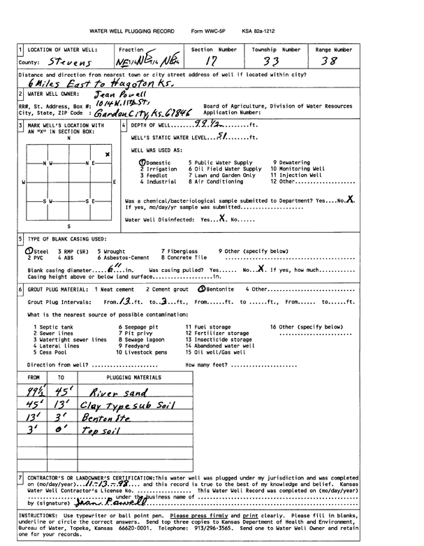
T33S, R38W, Sec. 17 NE NE NE |
Powell, Jean | 99.5 ft. | 51 ft. | Domestic | Plugged | 13-Nov-1998 | Scan | ||
|
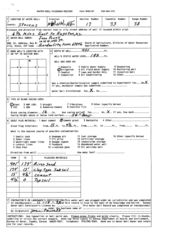
T33S, R38W, Sec. 17 NE NW NE |
Powell, Jean | 401 ft. | 188 ft. | Irrigation | Plugged | 14-Nov-1998 | Scan | ||
|
T33S, R38W, Sec. 17 NE SW NE |
Powell, Jean | 161 ft. | Oil Field Water Supply | Plugged | 13-Nov-1998 | ||||
|
T33S, R38W, Sec. 17 SW SW NW |
Willis, Warren M. and Amanda R. | 436 ft. | 255 ft. | 800 gpm. | Irrigation | Constructed | 26-Feb-2024 |
KOLAR |
|
|
T33S, R38W, Sec. 18 SW SW SW |
Heger, Gary | 429 ft. | 110 ft. | 500 gpm. | Irrigation | Constructed | 20-Dec-1988 | ||
|
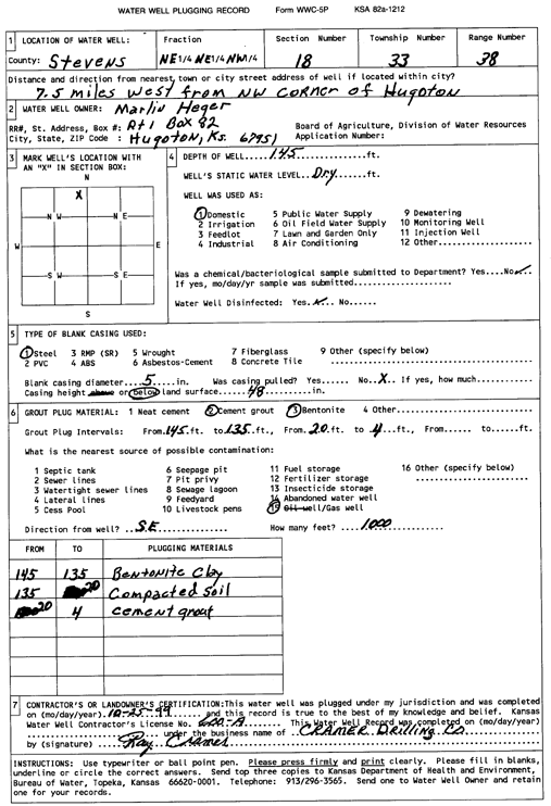
T33S, R38W, Sec. 18 NE NE NW |
Heger, Marlin | 145 ft. | Domestic | Plugged | 25-Oct-1999 | Scan | |||
|
T33S, R38W, Sec. 18 SW SE NE |
Shafer Family Farms | 375 ft. | 236 ft. | 106 gpm. | Irrigation | Constructed | 02-May-2023 |
KOLAR |
|
|
T33S, R38W, Sec. 18 NW NE SW |
Shaffer, Bob | 383 ft. | 147 ft. | Irrigation | Constructed | 05-Oct-2010 | |||
|
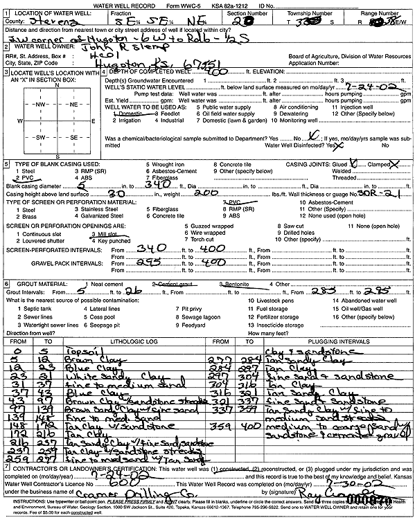
T33S, R38W, Sec. 18 SE SE SE |
Slemp, John R. | 380 ft. | 215 ft. | Irrigation | Constructed | 31-Oct-2001 | Scan | ||
|
T33S, R38W, Sec. 20 NE SW SW |
Gabbert and Jones | 340 ft. | 180 ft. | 70 gpm. | Oil Field Water Supply | Gilbert A-1 | Constructed | 21-Jul-1989 | |
|
T33S, R38W, Sec. 20 NE NW NE |
Slemp, John | 400 ft. | 220 ft. | Domestic | Plugged | 12-Dec-1999 | Scan | ||
|
T33S, R38W, Sec. 20 SE NE SE |
Slemp, John | 436 ft. | 164 ft. | 2100 gpm. | Irrigation | Constructed | 31-Oct-1978 | ||
|
T33S, R38W, Sec. 20 SE SE NE |
Slemp, John R. | 400 ft. | Domestic | Constructed | 04-Jul-2002 | Scan | |||
|
T33S, R38W, Sec. 20 SE NE NE |
Slemp, Larry | 401 ft. | 189 ft. | Domestic | Constructed | 09-May-1981 | |||
|
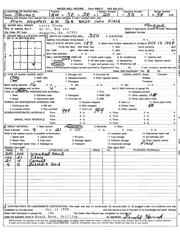
T33S, R38W, Sec. 20 NW SE SE |
Slemp, Larry | 350 ft. | 185 ft. | Irrigation | Plugged | 13-Oct-1998 | Scan | ||
|
T33S, R38W, Sec. 20 NE NE NW |
Willis, Warren | 461 ft. | 282 ft. | Irrigation | Constructed | 11-Mar-2026 |
KOLAR |
||
|
T33S, R38W, Sec. 20 C E2 SE |
Willis, Warren | 455 ft. | 208 ft. | Irrigation | Constructed | 31-Mar-2007 | |||
|
T33S, R38W, Sec. 21 SW NW NW |
Farrar, Keith | 422 ft. | 210 ft. | Irrigation | Constructed | 28-Apr-2006 | |||
|
T33S, R38W, Sec. 21 SW SW NW |
Farrar, Keith | 430 ft. | 215 ft. | Irrigation | Plugged | 27-Sep-2006 | |||
|
T33S, R38W, Sec. 21 SW SW NW |
Farrar, Keith | 430 ft. | 215 ft. | Irrigation | Plugged | 27-Sep-2006 | |||
|
T33S, R38W, Sec. 21 NE NW NW |
Farrar, Keith | 420 ft. | 160 ft. | 30 gpm. | Domestic | Constructed | 17-Dec-1980 | ||
|
T33S, R38W, Sec. 21 C S2 SW |
Farrar, Keith | 290 ft. | 135 ft. | 60 gpm. | Oil Field Water Supply | Constructed | 25-May-1982 | ||
|
T33S, R38W, Sec. 21 NW NW NW |
Farrar, Vance | 440 ft. | 160 ft. | 30 gpm. | Domestic | Constructed | 09-Nov-1994 | ||
|
T33S, R38W, Sec. 21 NW NW NE SE |
Willis, Warren and Amanda | 538 ft. | 277 ft. | 2140 gpm. | Irrigation | Constructed | 26-Oct-2021 |
KOLAR |
|
|
T33S, R38W, Sec. 21 NW SW NW |
460 ft. | Test Hole, Uncased | Constructed | 04-Nov-1965 | |||||
|
T33S, R38W, Sec. 21 SW NW NW |
463 ft. | Test Hole, Uncased | Constructed | 01-Nov-1965 | |||||
|
T33S, R38W, Sec. 22 SW SW SW |
EOG Resources, Inc. | 420 ft. | 201 ft. | 100 gpm. | Oil Field Water Supply | Aber 2 / Wilma 22-1 | Constructed | 21-May-2006 | |
|
T33S, R38W, Sec. 22 C NE NE |
Mobil Oil Corp./Harold Coulter | 260 ft. | 113 ft. | 100 gpm. | Oil Field Water Supply | Coulter 1-3 | Constructed | 14-Jul-1984 | |
|
T33S, R38W, Sec. 23 SW SW SW |
Coulter, Gilbert | 240 ft. | 200 ft. | Domestic | Plugged | 09-Dec-2004 | |||
|
T33S, R38W, Sec. 23 SE SE NE |
Kramer, Jim | 520 ft. | Domestic | Constructed | 08-Nov-2011 | ||||
|
T33S, R38W, Sec. 24 SW NE SE |
Palego Properties | 570 ft. | 146 ft. | Monitoring well/observation/piezometer | Constructed | 15-Sep-1995 | |||
|
T33S, R38W, Sec. 24 SW NE SE |
Palego Properties | 566 ft. | 146 ft. | Irrigation | Constructed | 12-Oct-1994 | |||
|
T33S, R38W, Sec. 24 NE NW NW |
Pelajo Properties | 549 ft. | 179 ft. | Monitoring well/observation/piezometer | Constructed | 08-Apr-1998 | |||
|
T33S, R38W, Sec. 24 NE NW NW |
Pelajo Properties | 549 ft. | 179 ft. | 1500 gpm. | Irrigation | Constructed | 14-Apr-1998 | ||
|
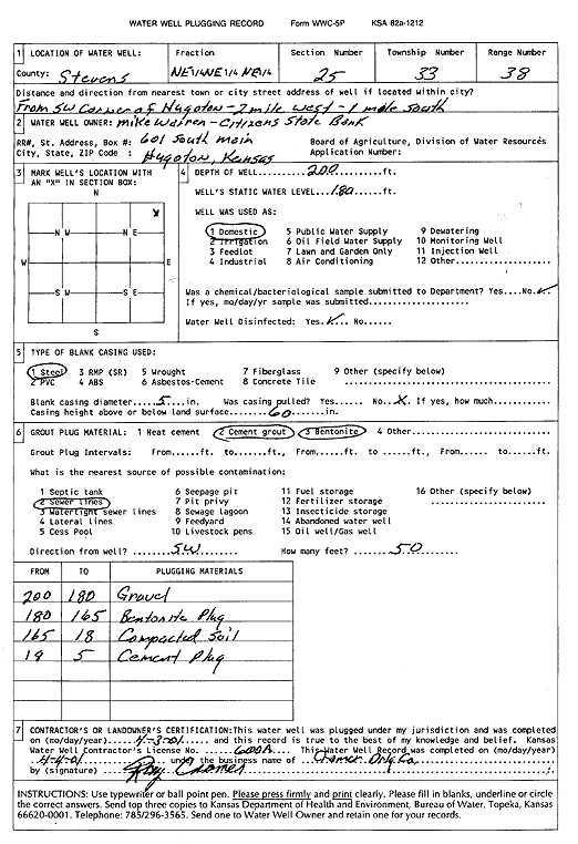
T33S, R38W, Sec. 25 NE NE NE |
Citizens State Bank | 200 ft. | 180 ft. | Domestic | Plugged | 03-Apr-2001 | Scan | ||
|
T33S, R38W, Sec. 25 NE NE NE |
Greenwood, Carrie | 265 ft. | 148 ft. | 50 gpm. | Domestic, Livestock | Constructed | 05-Sep-1985 | ||
|
T33S, R38W, Sec. 25 SE SE NE |
Kramer Properties | 320 ft. | 113 ft. | 60 gpm. | Domestic | Constructed | 30-Mar-1976 | ||
|
T33S, R38W, Sec. 25 SW NW NW |
Palego Properties | 497 ft. | 145 ft. | Monitoring well/observation/piezometer | Constructed | 16-Sep-1994 | |||
|
T33S, R38W, Sec. 25 SW NW NW |
Palego Properties | 555 ft. | 145 ft. | Irrigation | Constructed | 15-Feb-1995 | |||
|
T33S, R38W, Sec. 25 NW SW SE SE |
Pelajo Properties | 600 ft. | 230 ft. | 2635 gpm. | Irrigation | Constructed | 18-Dec-2012 |
KOLAR |
|
|
T33S, R38W, Sec. 26 NE NE NE |
Claggett, Gayle | 537 ft. | Domestic | Constructed | 31-Aug-2011 | ||||
|
T33S, R38W, Sec. 26 NE NE NE |
Slemp, Larry D. | 260 ft. | 155 ft. | 50 gpm. | Domestic | Constructed | 29-Nov-1985 | ||
|
T33S, R38W, Sec. 27 SE SW SW |
Batie, David | 500 ft. | 305 ft. | 50 gpm. | Domestic | Constructed | 16-Sep-2025 |
KOLAR |
|
|
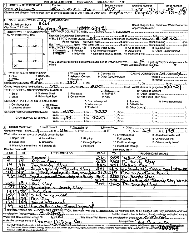
T33S, R38W, Sec. 27 SW SW SW |
Holcomb, Jay | 300 ft. | 118 ft. | Domestic | Constructed | 04-Jun-1998 | |||
|
T33S, R38W, Sec. 27 SW SW SW |
Holcomb, Jay | 320 ft. | 116 ft. | Domestic | Constructed | 25-May-2002 | Scan | ||
|
T33S, R38W, Sec. 27 NE SW NW |
Mobil Oil Corp./Howard Holcomb | 360 ft. | 155 ft. | 100 gpm. | Oil Field Water Supply | Coulter 4 Unit 2 | Constructed | 29-Dec-1989 | |
|
T33S, R38W, Sec. 28 C NE NE |
Coulter, Rex | 440 ft. | 150 ft. | 70 gpm. | Domestic | Constructed | 27-Apr-1982 | ||
| View page: < Prev || 31 || 32 || 33 || 34 || 35 || 36 || 37 || 38 || 39 || 40 || Next > | |||||||||