Select location of well to view details.
Click on column heading to sort.
|
|
|
County: Stevens Select location of well to view details. Click on column heading to sort. |
|
|
|
| View page: < Prev || 51 || 52 | |||||||||
| T-R-S | Owner | Well Depth Ascend. Desc. |
Static Water Level Ascend. Desc. |
Est. Yield Ascend. Desc. |
Well Use | Other ID | Action Taken | Completion Date Ascend. Desc. |
Scan? |
|
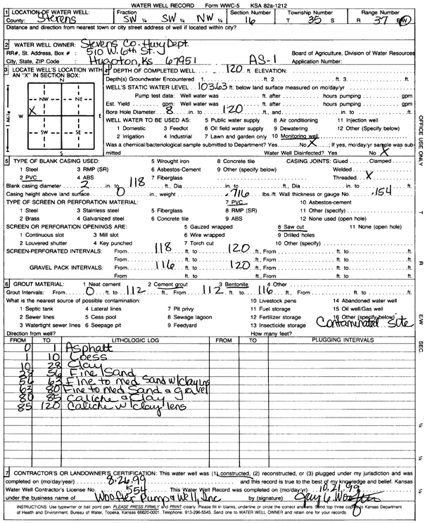
T35S, R37W, Sec. 16 SW SW NW |
Stevens Co. Hwy Dept. | 120 ft. | 103.6 ft. | Monitoring well/observation/piezometer | AS 1 | Constructed | 26-Aug-1999 | Scan | |
|
T35S, R37W, Sec. 17 SE SW SW |
G & T Farms Partnership | 602 ft. | 320 ft. | 50 gpm. | Domestic | Constructed | 07-Aug-2025 |
KOLAR |
|
|
T35S, R37W, Sec. 17 SW SW SE |
Grewell, Donald | 621 ft. | 164 ft. | 1600 gpm. | Irrigation | Constructed | 24-Mar-1995 | ||
|
T35S, R37W, Sec. 17 SE NW SW |
Grewell, Donald Paul | 681 ft. | 287 ft. | 400 gpm. | Irrigation | IRR-1-24 | Constructed | 15-Mar-2024 |
KOLAR |
|
T35S, R37W, Sec. 17 NW NE NE |
Grewell, Greg | 420 ft. | 165 ft. | Domestic | Constructed | 26-Aug-1999 | Scan | ||
|
T35S, R37W, Sec. 17 SE SW SW |
Grewell, Paul | 390 ft. | 215 ft. | Domestic | Constructed | 16-Aug-2005 | |||
|
T35S, R37W, Sec. 17 SE SW SW |
Grewell, Paul | 295 ft. | 215 ft. | Domestic | Plugged | 22-Aug-2005 | |||
|
T35S, R37W, Sec. 17 SE SW SW |
Grewell, Paul | 355 ft. | 180 ft. | 50 gpm. | Domestic | Constructed | 17-Aug-1995 | ||
|
T35S, R37W, Sec. 17 NW NE NW |
Grewell, Paul | 310 ft. | 179 ft. | Domestic | Constructed | 22-Feb-2001 | Scan | ||
|
T35S, R37W, Sec. 17 C SE |
Mobil Oil Corp./Paul Grewell | 280 ft. | 142 ft. | 60 gpm. | Oil Field Water Supply | Statton Unit 1-2 | Constructed | 10-May-1984 | |
|
T35S, R37W, Sec. 18 SE SW SW |
EOG Resources Inc | 440 ft. | 216 ft. | 100 gpm. | Oil Field Water Supply | Maxine 18-1 | Constructed | 09-Jan-2009 | |
|
T35S, R37W, Sec. 18 SE SW SW |
EOG Resources INC | 360 ft. | 220 ft. | 100 gpm. | Oil Field Water Supply | Normaa 18-1 | Constructed | 10-Oct-2007 | |
|
T35S, R37W, Sec. 18 SW SW SW |
EOG Resources Inc. | 360 ft. | 228 ft. | Oil Field Water Supply | Norma 18 1 | Plugged | 25-Mar-2008 | ||
|
T35S, R37W, Sec. 18 NE NE NE |
Grewell, Greg | 480 ft. | Domestic | Constructed | 28-Oct-2010 | ||||
|
T35S, R38W, Sec. 1 C NE |
Anadarko Petroleum Corp. | 155 ft. | Oil Field Water Supply | Bundy 1 | Plugged | 15-Feb-1996 | Scan | ||
|
T35S, R38W, Sec. 1 NW NW NW |
Beesley, Walter | 154 ft. | Domestic, Livestock | Plugged | 09-Feb-2012 | ||||
|
T35S, R38W, Sec. 1 NE SW SE |
Cox, Roy | 560 ft. | 172 ft. | Monitoring well/observation/piezometer | Constructed | 18-Apr-1996 | |||
|
T35S, R38W, Sec. 1 NE SW SE |
Cox, Roy | 676 ft. | 170 ft. | 1500 gpm. | Irrigation | Constructed | 07-May-1998 | ||
|
T35S, R38W, Sec. 1 NE NE SE |
Cox, Roy | 560 ft. | 179 ft. | Monitoring well/observation/piezometer | Constructed | 18-Jul-1996 | |||
|
T35S, R38W, Sec. 1 NW SW SW |
EOG Resources, Inc. | 360 ft. | 236 ft. | 120 gpm. | Oil Field Water Supply | Jayhawk 1 | Constructed | 18-Nov-2005 | |
|
T35S, R38W, Sec. 1 SW NW NE |
Mid America Cattle Co. | 600 ft. | 291 ft. | 50 gpm. | Domestic, Livestock | Constructed | 03-Aug-2023 |
KOLAR |
|
|
T35S, R38W, Sec. 1 C NW |
Mid America Cattle Co. | 631 ft. | 182 ft. | 1600 gpm. | Feedlot | Constructed | 10-Oct-1997 | ||
|
T35S, R38W, Sec. 1 NE SW NE SE |
Sturdy, Troy | 355 ft. | 226 ft. | 50 gpm. | Domestic | Constructed | 18-May-2008 | ||
|
T35S, R38W, Sec. 2 SE SE SE |
Grewell, Paul | 668 ft. | 186 ft. | 1525 gpm. | Irrigation | Constructed | 29-Jan-1997 | ||
|
T35S, R38W, Sec. 3 NW SW SE |
Brecheison, Al | 390 ft. | 157 ft. | 2000 gpm. | Irrigation | Constructed | 31-Mar-1975 | ||
|
T35S, R38W, Sec. 3 NW SE |
Brecherson, Gaylen | 580 ft. | 200 ft. | 100 gpm. | Domestic | Constructed | 10-Sep-2013 | ||
|
T35S, R38W, Sec. 4 NE NE NW |
Anadarko Petroleum Corp. | 400 ft. | 238 ft. | 100 gpm. | Oil Field Water Supply | Landers A-1 | Constructed | 12-Jun-2004 | |
|
T35S, R38W, Sec. 4 NE NE NW |
Trujillo, Tyler | 704 ft. | 280 ft. | Irrigation | Constructed | 28-Aug-2022 | |||
|
T35S, R38W, Sec. 5 SW SW NE |
Ferguson, Charles R. | 587 ft. | 227 ft. | Irrigation | Constructed | 24-Mar-1999 | Scan | ||
|
T35S, R38W, Sec. 6 SE SE NW |
Kramer Enterprises | 420 ft. | 170 ft. | Monitoring well/observation/piezometer | Constructed | 28-Jan-1996 | |||
|
T35S, R38W, Sec. 6 SE SE NW |
Kramer Properties | 595 ft. | 226 ft. | 1800 gpm. | Irrigation | Constructed | 10-Jun-1998 | ||
|
T35S, R38W, Sec. 6 SE SE NW |
Kramer Properties | 595 ft. | 226 ft. | Monitoring well/observation/piezometer | Constructed | 11-Jun-1998 | |||
|
T35S, R38W, Sec. 6 SW SW SW |
Kramer, James | 560 ft. | 179 ft. | Monitoring well/observation/piezometer | Constructed | 23-Jul-1996 | |||
|
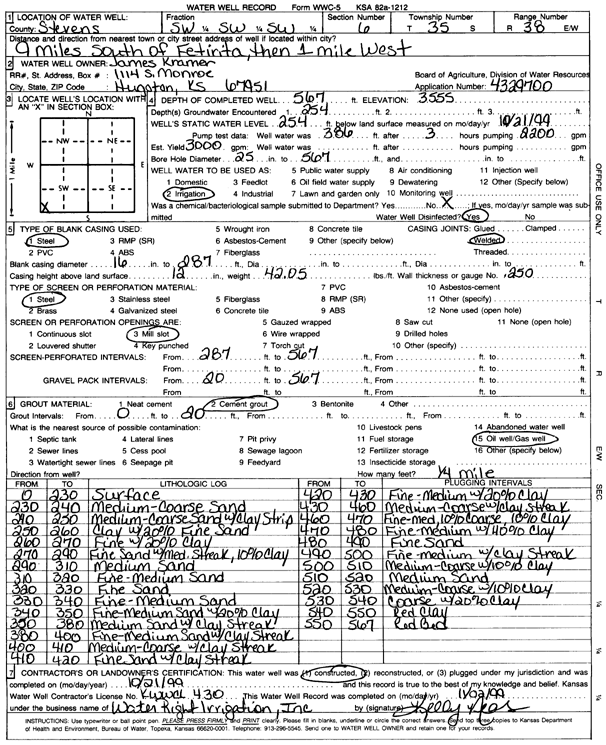
T35S, R38W, Sec. 6 SW SW SW |
Kramer, James | 567 ft. | 254 ft. | 3000 gpm. | Irrigation | Constructed | 21-Oct-1999 | Scan | |
|
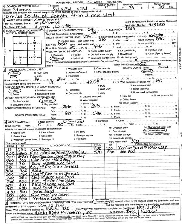
T35S, R38W, Sec. 7 SW SW SW |
Kramer, James | 546 ft. | 254 ft. | 850 gpm. | Irrigation | Constructed | 15-Oct-1999 | Scan | |
|
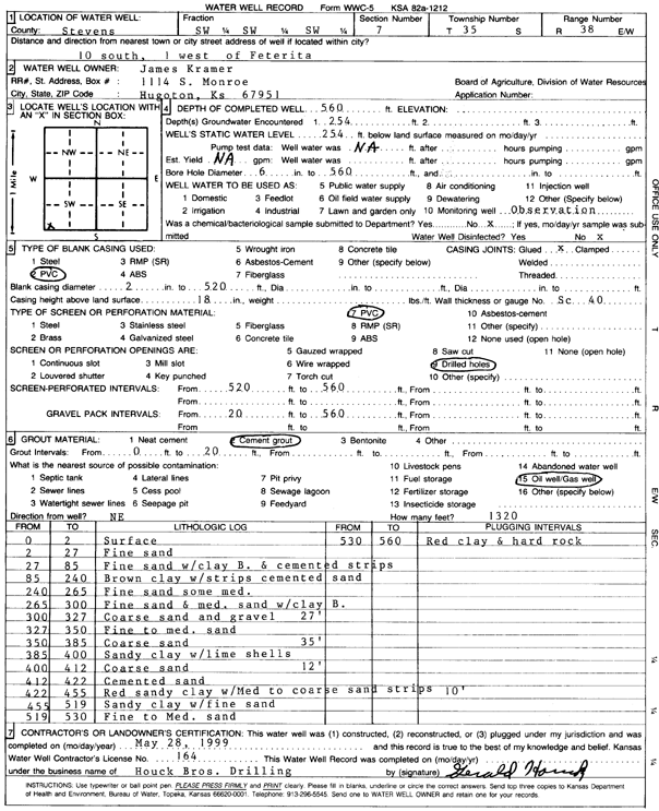
T35S, R38W, Sec. 7 SW SW SW |
Kramer, James | 560 ft. | 254 ft. | Monitoring well/observation/piezometer | Constructed | 28-May-1999 | Scan | ||
|
T35S, R38W, Sec. 7 SESESW |
Seaboard Farms Co. | 460 ft. | 230 ft. | 120 gpm. | Domestic, Livestock | Kramer South Well | Constructed | 25-Apr-1996 | |
|
T35S, R38W, Sec. 7 NE NE NW |
Seaboard Farms Co. | 400 ft. | 190 ft. | 100 gpm. | Domestic, Livestock | Kramer North Well | Constructed | 24-Apr-1996 | |
|
T35S, R38W, Sec. 8 SE SE SW |
EOG Resources, Inc. | 360 ft. | 285 ft. | 100 gpm. | Oil Field Water Supply | Ansley HJV 8-1 | Constructed | 16-Dec-2005 | |
|
T35S, R38W, Sec. 9 S2 S2 SW |
Berexco Inc. | 320 ft. | 210 ft. | 85 gpm. | Oil Field Water Supply | Brecheisen 1-9 | Constructed | 08-Nov-1994 | |
|
T35S, R38W, Sec. 9 NE SW SW |
Brecheisen, Charles | 380 ft. | 167 ft. | 2000 gpm. | Irrigation | Constructed | 06-Jun-1975 | ||
|
T35S, R38W, Sec. 9 NW NE SW SW |
Charles P. Brecheisen Estate | 620 ft. | 292 ft. | 947 gpm. | Irrigation | Constructed | 09-Feb-2019 |
KOLAR |
|
|
T35S, R38W, Sec. 10 SE NE SW |
Brecheisen, Al | 280 ft. | 168 ft. | Domestic | Constructed | 30-Nov-1986 | |||
|
T35S, R38W, Sec. 10 C SE |
Brecheisen, Al M. | 501 ft. | 200 ft. | Irrigation | Constructed | 18-Apr-1997 | |||
|
T35S, R38W, Sec. 11 NW NW NW |
Fitzgerald, John | 490 ft. | Domestic | Constructed | 26-Sep-2005 | ||||
|
T35S, R38W, Sec. 11 NW NW SE |
Kramer Enterprises | 260 ft. | 170 ft. | Monitoring well/observation/piezometer | Constructed | 05-Jan-1996 | |||
|
T35S, R38W, Sec. 11 NW NW SE |
Kramer Enterprises | 265 ft. | 178 ft. | Monitoring well/observation/piezometer | Constructed | 12-Mar-1997 | |||
|
T35S, R38W, Sec. 11 NW NW SE |
Kramer Enterprises | 504.6 ft. | 178 ft. | Irrigation | Constructed | 06-May-1997 | |||
|
T35S, R38W, Sec. 11 NW NW NW SE |
Mid America Cattle Co | 400 ft. | 260 ft. | Domestic, Livestock | Plugged | 07-Jan-2016 | |||
|
T35S, R38W, Sec. 11 SW SW SE NW |
MID AMERICA CATTLE- WALTER BEESLEY | 653 ft. | 251 ft. | 2209 gpm. | Irrigation | Constructed | 27-Sep-2012 |
KOLAR |
|
| View page: < Prev || 51 || 52 | |||||||||