Select location of well to view details.
Click on column heading to sort.
|
|
|
County: Stevens Select location of well to view details. Click on column heading to sort. |
|
|
|
| View page: 1 || 2 || 3 || 4 || 5 || 6 || 7 || 8 || 9 || 10 || Next > | |||||||||
| T-R-S | Owner | Well Depth Ascend. Desc. |
Static Water Level Ascend. Desc. |
Est. Yield Ascend. Desc. |
Well Use | Other ID | Action Taken | Completion Date Ascend. Desc. |
Scan? |
|
T31S, R38W, Sec. 16 SW SW NE |
River Bend Feeders | 410 ft. | 210 ft. | Feedlot | Constructed | 23-Sep-1991 | |||
|
T31S, R38W, Sec. 16 NW NW SE |
River Bend Feeders | 400 ft. | 200 ft. | Feedlot | Constructed | 18-Sep-1991 | |||
|
T31S, R38W, Sec. 16 SW SW NE |
River Bend Feeders | 410 ft. | 205 ft. | Feedlot | Constructed | 11-Dec-1992 | |||
|
T31S, R38W, Sec. 16 SE S ENW |
River Bend Feeders | 420 ft. | 206 ft. | Feedlot | Constructed | 27-Sep-1991 | |||
|
T31S, R38W, Sec. 16 NE NW NE |
River Bend Feeders | 454 ft. | 255 ft. | Feedlot | Constructed | 27-Jul-1998 | |||
|
T31S, R38W, Sec. 16 NW NW NE |
Seaboard Farms Co. | 400 ft. | 250 ft. | Feedlot | Plugged | 26-Dec-2006 | |||
|
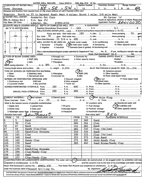
T31S, R38W, Sec. 17 C SW SW |
Anadarko Petroleum Corp. | 400 ft. | 230 ft. | 80 gpm. | Oil Field Water Supply | Spikes G-1 | Constructed | 03-Oct-1994 | |
|
T31S, R38W, Sec. 17 C SW SW |
Anadarko Petroleum Corp. | 400 ft. | 220 ft. | Oil Field Water Supply | Spikes G-1 | Plugged | 07-Feb-1995 | ||
|
T31S, R38W, Sec. 17 NW NW SW |
Kansas Geological Survey | 460 ft. | 311 ft. | 5 gpm. | Monitoring well/observation/piezometer | Constructed | 25-Jun-2025 |
KOLAR |
|
|
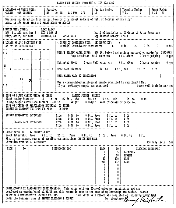
T31S, R38W, Sec. 17 C S2 |
Rome Farms | 432 ft. | 275 ft. | Irrigation | Constructed | 14-Oct-2003 | Scan | ||
|
T31S, R38W, Sec. 17 NE SE SW |
Rome Farms | 432 ft. | 270 ft. | Irrigation | Plugged | 20-Dec-2003 | Scan | ||
|
T31S, R38W, Sec. 17 NW SE NW |
Timmons Family Partnership | 450 ft. | 260 ft. | Irrigation | Constructed | 16-Sep-2005 | |||
|
T31S, R38W, Sec. 17 NW SE NE |
Timmons, Mrs. Paul | 411 ft. | 186 ft. | 1250 gpm. | Irrigation | Constructed | 17-Jun-1977 | ||
|
T31S, R38W, Sec. 19 SE SE SE |
Dale, Eldon | 360 ft. | 143 ft. | Domestic | Constructed | 24-Apr-1976 | |||
|
T31S, R38W, Sec. 20 C SW NW |
Anadarko Petroleum Corp. | 400 ft. | 220 ft. | 50 gpm. | Oil Field Water Supply | Spikes A-4 | Constructed | 31-Oct-1992 | |
|
T31S, R38W, Sec. 20 C SW NW |
Gabbert and Jones | 400 ft. | 220 ft. | Oil Field Water Supply | Spikes A-4 | Plugged | 25-Mar-1993 | ||
|
T31S, R38W, Sec. 20 NW NW SW |
Oxy USA, Inc. | 360 ft. | 160 ft. | Oil Field Water Supply | MLP KS Univ. A-1 | Plugged | 15-Mar-1994 | ||
|
T31S, R38W, Sec. 20 NW NW SW |
Oxy USA, Inc. | 360 ft. | 160 ft. | 110 gpm. | Oil Field Water Supply | MLP KS Univ. A-1 | Constructed | 09-Sep-1993 | |
|
T31S, R38W, Sec. 20 C N2 NW NE |
Spikes, Warren | 450 ft. | 203 ft. | Irrigation | Constructed | 29-Jan-1996 | |||
|
T31S, R38W, Sec. 20 S2 SE |
Tarbet, Steve | 172 ft. | Domestic, Livestock | Plugged | 09-Sep-2006 | ||||
|
T31S, R38W, Sec. 21 SE SE SE |
Keith, Jan | 470 ft. | Feedlot | Constructed | 09-Jun-1995 | ||||
|
T31S, R38W, Sec. 21 NE NW NE |
Spikes, Warren | 366 ft. | 172 ft. | Domestic | Constructed | 12-Sep-1997 | |||
|
T31S, R38W, Sec. 21 SW SE SW |
180 ft. | Domestic, Livestock | Plugged | 02-Sep-2006 | |||||
|
T31S, R38W, Sec. 22 NW SE SE |
Persinger, Jim | 485 ft. | 267 ft. | 50 gpm. | Domestic, Livestock | Constructed | 15-Oct-2024 |
KOLAR |
|
|
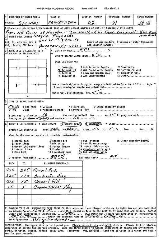
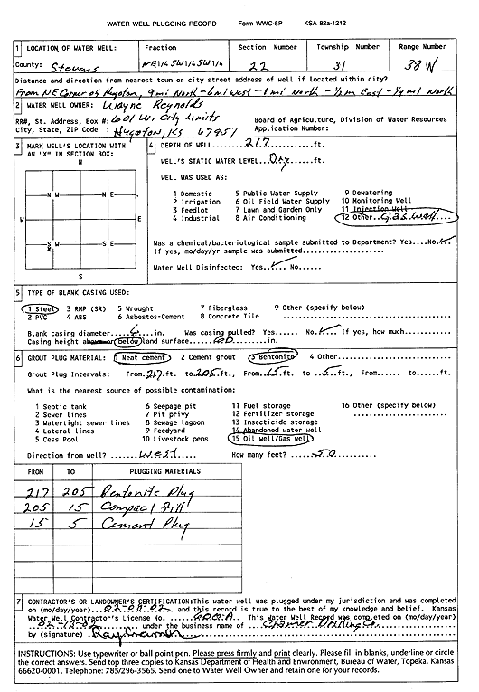
T31S, R38W, Sec. 22 SW NE SW |
Reynolds, Wayne | 480 ft. | 231 ft. | Irrigation | Constructed | 11-Jan-2002 | Scan | ||
|
T31S, R38W, Sec. 22 NE SW SW |
Reynolds, Wayne | 450 ft. | 230 ft. | Irrigation | Plugged | 08-Feb-2002 | Scan | ||
|
T31S, R38W, Sec. 22 NE SW SW |
Reynolds, Wayne | 217 ft. | Recovery/Soil Vapor Extraction/Soil Vent | Plugged | 08-Feb-2002 | Scan | |||
|
T31S, R38W, Sec. 22 SE SE SW SW |
Reynolds, Wayne | 400 ft. | 235 ft. | Domestic | Constructed | 10-Apr-2002 | Scan | ||
|
T31S, R38W, Sec. 23 SE SE NE NW |
Rome Farms | 477 ft. | 277 ft. | 1547 gpm. | Irrigation | Constructed | 17-Mar-2016 |
KOLAR |
|
|
T31S, R38W, Sec. 23 C SW |
Stevens County Grazing Assoc. | 400 ft. | 183 ft. | 60 gpm. | Domestic | Constructed | 17-Dec-1990 | ||
|
T31S, R38W, Sec. 24 NE NE SW |
Keith, Jan | 501 ft. | 210 ft. | Irrigation | Constructed | 03-Oct-1991 | |||
|
T31S, R38W, Sec. 25 NW NW NW |
Loibil, Gregg | 507 ft. | 248 ft. | 50 gpm. | Domestic | Constructed | 17-Oct-2014 | ||
|
T31S, R38W, Sec. 25 NE NE NE |
Persinger, Majorie C. | 488 ft. | 223 ft. | Irrigation | Reconstructed | 17-May-1994 | |||
|
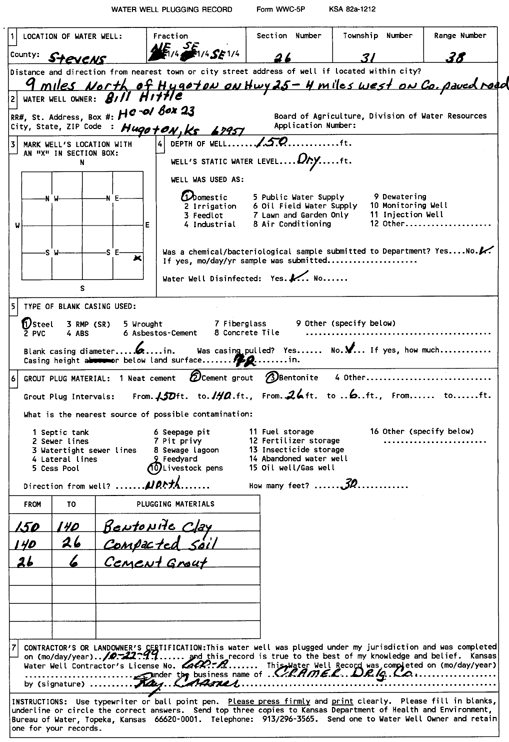
T31S, R38W, Sec. 26 SW NE SE |
Hittle, Bill | 470 ft. | 219 ft. | Irrigation | Constructed | 21-Jun-2010 | |||
|
T31S, R38W, Sec. 26 NE SE SE |
Hittle, Bill | 150 ft. | Domestic | Plugged | 22-Oct-1999 | Scan | |||
|
T31S, R38W, Sec. 26 NE SE SE |
Hittle, Linda | 526 ft. | 265 ft. | 50 gpm. | Domestic | Constructed | 15-Mar-2023 |
KOLAR |
|
|
T31S, R38W, Sec. 26 NW SW NW |
Schowalter Foundation | 506 ft. | 214 ft. | Irrigation | Constructed | 10-Mar-2004 | Scan | ||
|
T31S, R38W, Sec. 27 NW SW SW |
Anadarko Petroleum Corp. | 380 ft. | 196 ft. | 100 gpm. | Oil Field Water Supply | Schowalter A-2 | Constructed | 30-May-2003 | |
|
T31S, R38W, Sec. 27 SE NE NE NW |
Wayne and Evalena Reynolds Living Trust | 470 ft. | 265 ft. | 508 gpm. | Irrigation | Constructed | 23-May-2019 |
KOLAR |
|
|
T31S, R38W, Sec. 28 SE NE NW |
Anadarko Petroleum Corp. | 400 ft. | 156 ft. | 95 gpm. | Oil Field Water Supply | Spikes A 5-H | Constructed | 24-Aug-1997 | |
|
T31S, R38W, Sec. 29 SW SE SE |
Cavner, Loretta | 337 ft. | 121 ft. | 25 gpm. | Domestic | Constructed | 28-Apr-1982 | ||
|
T31S, R38W, Sec. 30 E2 W2 NE |
Oxy USA, Inc. | 300 ft. | 140 ft. | 100 gpm. | Oil Field Water Supply | MLP Smith A-1 | Constructed | 03-Oct-1991 | |
|
T31S, R38W, Sec. 30 E2 W2 NE |
Oxy USA, Inc. | 300 ft. | 140 ft. | Oil Field Water Supply | MLP Smith A-1 | Plugged | 30-Jan-1992 | ||
|
T31S, R38W, Sec. 30 SW SE NW |
Schmidt, Gerald | 130 ft. | 70 ft. | Domestic, Livestock | Constructed | 09-May-1980 | |||
|
T31S, R38W, Sec. 31 SW NE NW |
Oxy USA, Inc. | 360 ft. | 60 ft. | 100 gpm. | Oil Field Water Supply | MLP Cavner A-1 | Constructed | 27-May-1995 | |
|
T31S, R38W, Sec. 31 NW NE NE |
Schmidt, G. Dennis | 150 ft. | 40 ft. | Domestic, Livestock | Constructed | 20-Apr-1982 | |||
|
T31S, R38W, Sec. 32 NW SE SE |
Gabbert and Jones | 295 ft. | 125 ft. | 60 gpm. | Oil Field Water Supply | Libby A-1 | Constructed | 23-Jul-1987 | |
|
T31S, R38W, Sec. 33 NE SE SW |
Anadarko Petroleum Corp. | 400 ft. | 165 ft. | 70 gpm. | Oil Field Water Supply | Cavner A-6 | Constructed | 04-Jan-2001 | Scan |
|
T31S, R38W, Sec. 33 SW NE NE NE |
Jay G and Mattie McClure Farms | 460 ft. | 214 ft. | 522 gpm. | Irrigation | Constructed | 11-Sep-2013 |
KOLAR |
|
|
T31S, R38W, Sec. 34 SE NW NW |
Anadarko Petroleum Corp. | 122 ft. | Oil Field Water Supply | McClure 1 | Plugged | 15-Feb-1996 | |||
| View page: 1 || 2 || 3 || 4 || 5 || 6 || 7 || 8 || 9 || 10 || Next > | |||||||||