Select location of well to view details.
Click on column heading to sort.
|
|
|
County: Coffey Select location of well to view details. Click on column heading to sort. |
|
|
|
| View page: 1 || 2 || 3 || 4 || 5 || 6 || 7 || 8 || 9 || 10 || Next > | |||||||||
| T-R-S | Owner | Well Depth Ascend. Desc. |
Static Water Level Ascend. Desc. |
Est. Yield Ascend. Desc. |
Well Use | Other ID | Action Taken | Completion Date Ascend. Desc. |
Scan? |
|
T21S, R15E, Sec. 17 SW SE SE SW |
Great Lakes Dredge and Dock Co, LLC | 37 ft. | Monitoring well/observation/piezometer | OB 9-19 | Constructed | 16-May-2019 | |||
|
T21S, R15E, Sec. 19 C SW SW |
K G and E; K C P and L | 24 ft. | Monitoring well/observation/piezometer | Constructed | 01-Nov-1980 | ||||
|
T21S, R15E, Sec. 19 SW SW SW |
K G and E; K C P and L | 33 ft. | Monitoring well/observation/piezometer | Constructed | 01-Nov-1980 | ||||
|
T21S, R15E, Sec. 19 SW SW SW |
K G and E; K C P and L | 33 ft. | Monitoring well/observation/piezometer | Constructed | 01-Nov-1980 | ||||
|
T21S, R15E, Sec. 19 NW SW SW |
K G and E; K C P and L | 19 ft. | Monitoring well/observation/piezometer | Constructed | 01-Nov-1980 | ||||
|
T21S, R15E, Sec. 21 NW NE SE |
Blauffus, Vic | 39 ft. | 11 ft. | 7 gpm. | Domestic, Lawn and Garden | Constructed | 06-Apr-2009 | ||
|
T21S, R15E, Sec. 21 NW NW NE |
Rife, Marold | 30 ft. | 16 ft. | 5 gpm. | Domestic | Constructed | 02-May-1981 | ||
|
T21S, R15E, Sec. 22 NW SE SW |
Clark, Lyle | 36 ft. | .5 gpm. | Domestic | Plugged | 20-Aug-2002 | Scan | ||
|
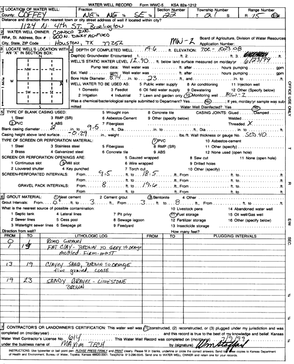
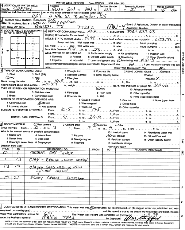
T21S, R15E, Sec. 22 NE NE SE |
Conoco Inc. | 19.6 ft. | 12.9 ft. | Monitoring well/observation/piezometer | MW 2 | Constructed | 23-Jun-1999 | Scan | |
|
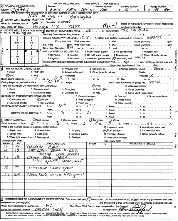
T21S, R15E, Sec. 22 NE NE SE |
Conoco Inc. | 21 ft. | 15.18 ft. | Monitoring well/observation/piezometer | MW 1 | Constructed | 23-Jun-1999 | Scan | |
|
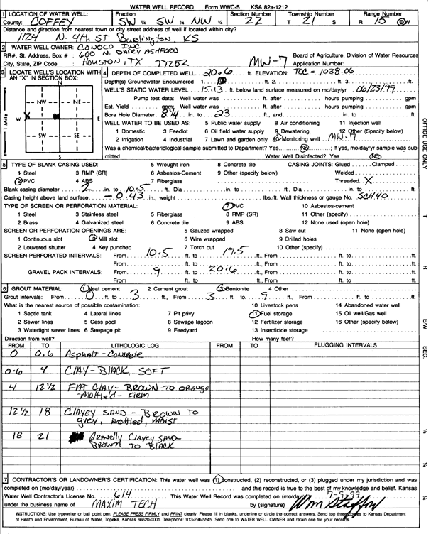
T21S, R15E, Sec. 22 SW SW NW |
Conoco Inc. | 20.6 ft. | 15.13 ft. | Monitoring well/observation/piezometer | MW 7 | Constructed | 23-Jun-1999 | Scan | |
|
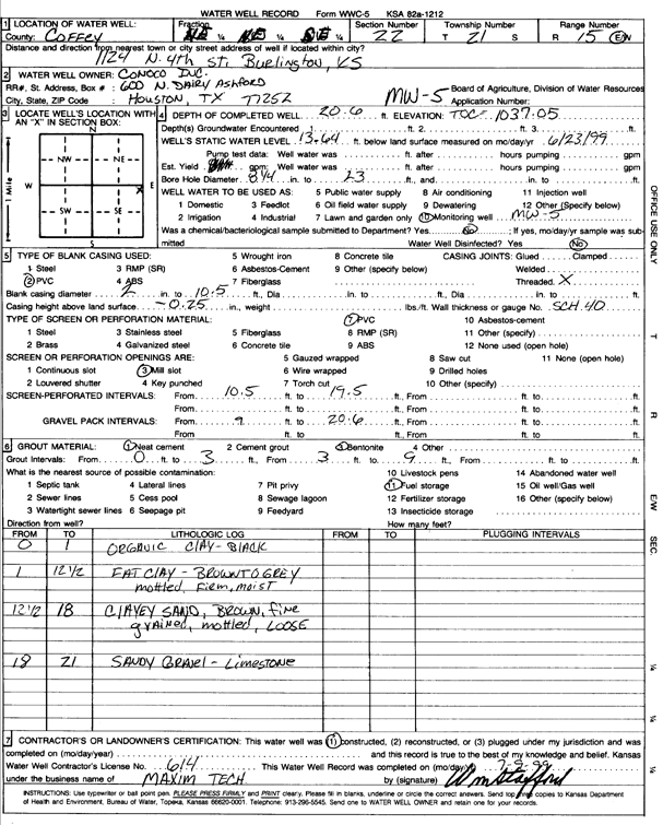
T21S, R15E, Sec. 22 NE NE SE |
Conoco Inc. | 20.6 ft. | 13.64 ft. | Monitoring well/observation/piezometer | MW 5 | Constructed | 23-Jun-1999 | Scan | |
|
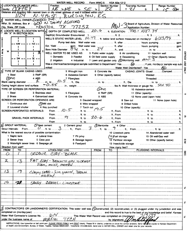
T21S, R15E, Sec. 22 NE NE SE |
Conoco Inc. | 20.6 ft. | 14.77 ft. | Monitoring well/observation/piezometer | MW 3 | Constructed | 23-Jun-1999 | Scan | |
|
T21S, R15E, Sec. 22 SE SE NE |
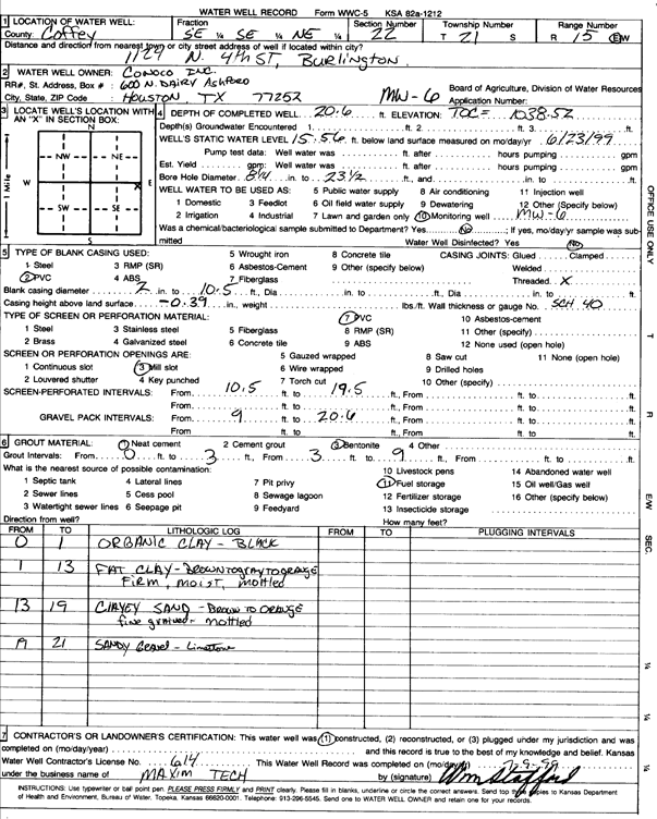
Conoco Inc. | 20.6 ft. | 15.56 ft. | Monitoring well/observation/piezometer | MW 6 | Constructed | 23-Jun-1999 | Scan | |
|
T21S, R15E, Sec. 22 NE NE SE |
ConocoPhillips | 24 ft. | Monitoring well/observation/piezometer | Constructed | 21-Jun-2012 | ||||
|
T21S, R15E, Sec. 22 SE SW NE |
Cooper, Eddie | 60 ft. | 7 ft. | 10 gpm. | Domestic | Constructed | 06-Jun-1989 | ||
|
T21S, R15E, Sec. 22 NW SE SE |
Cooper, Eddie | 60 ft. | 7 ft. | Irrigation | Constructed | 06-Jun-1989 | |||
|
T21S, R15E, Sec. 22 NE NW SE |
Lafferty, J. E. | 30 ft. | 15 ft. | 20 gpm. | Domestic, Lawn and Garden | Constructed | 26-Mar-1977 | ||
|
T21S, R15E, Sec. 22 SW SW SE |
Naylor, Robert | 38 ft. | 19 ft. | 6 gpm. | Domestic, Lawn and Garden | Constructed | 24-Aug-1984 | ||
|
T21S, R15E, Sec. 22 NE NE NE SE |
P66, Cardno ATC | 20 ft. | Monitoring well/observation/piezometer | Plugged | 08-Aug-2014 | ||||
|
T21S, R15E, Sec. 22 NE NE SE |
Phillips 66 Co. | 20 ft. | Monitoring well/observation/piezometer | MW 2 | Plugged | 01-Jun-2016 | |||
|
T21S, R15E, Sec. 22 NE NE SE |
Phillips 66 Co. | 20 ft. | 14.35 ft. | Monitoring well/observation/piezometer | MW 2 R | Constructed | 01-Jun-2016 | ||
|
T21S, R15E, Sec. 22 NE NE SE |
Phillips 66 Co. | 20 ft. | 15.18 ft. | Monitoring well/observation/piezometer | MW 7 R | Constructed | 01-Jun-2016 | ||
|
T21S, R15E, Sec. 22 NE NE SW |
Pieratt, Ralph | 25 ft. | 14 ft. | 50 gpm. | Domestic, Lawn and Garden | Constructed | 19-Sep-1978 | ||
|
T21S, R15E, Sec. 22 NE NE SE |
Sheets, George | 30 ft. | 16 ft. | 25 gpm. | Domestic, Lawn and Garden | Constructed | 25-Mar-1977 | ||
|
T21S, R15E, Sec. 22 SW SW NE |
USD 244 | 65 ft. | 60 ft. | (unstated)/abandoned | Plugged | 25-Sep-2013 | |||
|
T21S, R15E, Sec. 22 NE SW NE |
USD 244 | 92 ft. | 7 ft. | Irrigation | Constructed | 28-Jun-1989 | |||
|
T21S, R15E, Sec. 22 SW SW SW |
Woods, Frank | 38 ft. | 15 ft. | 20 gpm. | Domestic | Constructed | 02-Aug-1990 | ||
|
T21S, R15E, Sec. 23 NW NW SW |
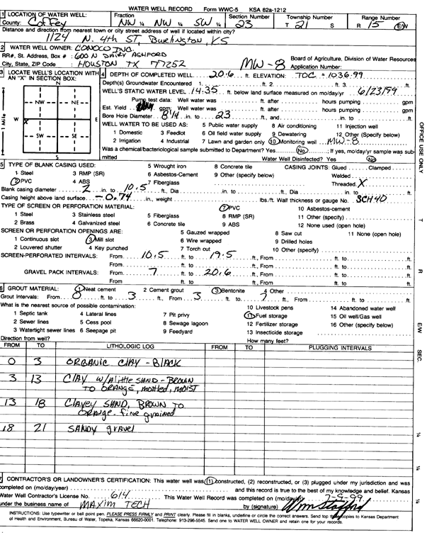
Conoco Inc. | 20.6 ft. | 14.35 ft. | Monitoring well/observation/piezometer | MW 8 | Constructed | 23-Jun-1999 | Scan | |
|
T21S, R15E, Sec. 23 NW NW SW |
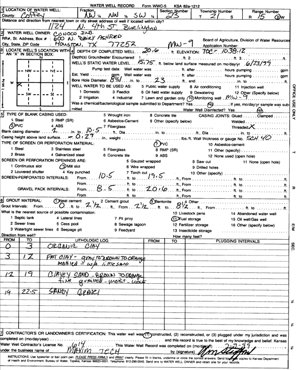
Conoco Inc. | 20.6 ft. | 15.75 ft. | Monitoring well/observation/piezometer | MW 9 | Constructed | 23-Jun-1999 | Scan | |
|
T21S, R15E, Sec. 23 SW SW NW |
Conoco Inc. | 20.6 ft. | 14.94 ft. | Monitoring well/observation/piezometer | MW 4 | Constructed | 23-Jun-1999 | Scan | |
|
T21S, R15E, Sec. 23 NW NW SW |
Lyon-Coffey Electric Cooperative | 270 ft. | Geothermal, Closed Loop, Vertical | Constructed | 10-Sep-1991 | ||||
|
T21S, R15E, Sec. 24 SE SE NW |
Coffey County | 57 ft. | Monitoring well/observation/piezometer | DW 7 | Constructed | 06-Nov-1997 | |||
|
T21S, R15E, Sec. 24 NE SE NE |
Coffey County | 46 ft. | 15.3 ft. | Monitoring well/observation/piezometer | DW-IT | Constructed | 19-Jul-1996 | ||
|
T21S, R15E, Sec. 24 SE NE |
Coffey County | 45 ft. | 9 ft. | Monitoring well/observation/piezometer | DW 2 | Constructed | 30-Nov-1995 | ||
|
T21S, R15E, Sec. 24 SE NE |
Coffey County | 17.2 ft. | Monitoring well/observation/piezometer | MW 5 | Constructed | 06-Jul-1995 | |||
|
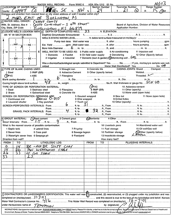
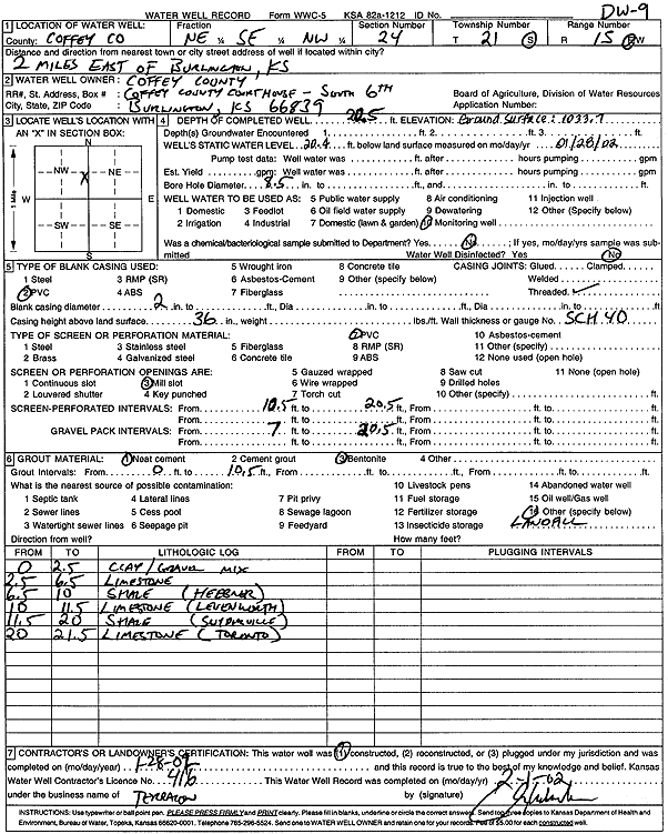
T21S, R15E, Sec. 24 NE SE NW |
Coffey County | 33 ft. | Monitoring well/observation/piezometer | MG 13 | Constructed | 07-Nov-2001 | Scan | ||
|
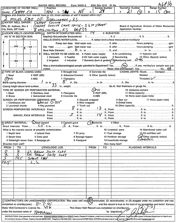
T21S, R15E, Sec. 24 NW SW NE |
Coffey County | 14 ft. | Monitoring well/observation/piezometer | MGP 16 | Constructed | 07-Nov-2001 | Scan | ||
|
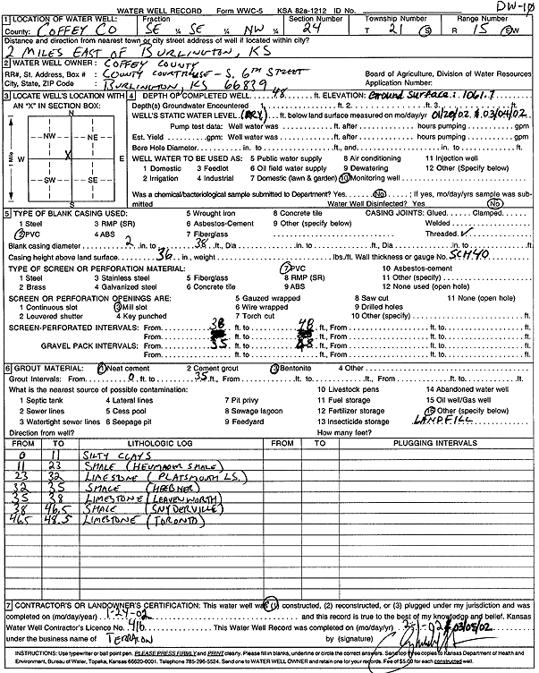
T21S, R15E, Sec. 24 SE SE NW |
Coffey County | 48 ft. | Monitoring well/observation/piezometer | DW 10 | Constructed | 24-Jan-2002 | Scan | ||
|
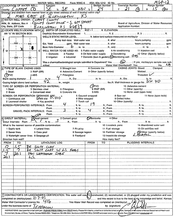
T21S, R15E, Sec. 24 NE SE NW |
Coffey County | 20.5 ft. | 20.4 ft. | Monitoring well/observation/piezometer | DW 9 | Constructed | 28-Jan-2002 | Scan | |
|
T21S, R15E, Sec. 24 NE SE NW |
Coffey County | 15 ft. | Monitoring well/observation/piezometer | MGP 15 | Constructed | 07-Nov-2001 | Scan | ||
|
T21S, R15E, Sec. 24 NE SW NE |
Coffey County | 39.5 ft. | 15.2 ft. | Monitoring well/observation/piezometer | DW 5 | Constructed | 16-Jul-1996 | ||
|
T21S, R15E, Sec. 24 SW SW NE |
Coffey County | 21 ft. | Monitoring well/observation/piezometer | MW 6 | Constructed | 19-Jul-1996 | |||
|
T21S, R15E, Sec. 24 SW SW NE |
Coffey County | 37 ft. | 34.2 ft. | Monitoring well/observation/piezometer | DW 3 | Constructed | 18-Jul-1996 | ||
|
T21S, R15E, Sec. 24 NE SE NW |
Coffey County | 25 ft. | Monitoring well/observation/piezometer | DW 6 | Constructed | 05-Nov-1997 | |||
|
T21S, R15E, Sec. 24 NE SE NW |
Coffey County | 24 ft. | 2.3 ft. | Monitoring well/observation/piezometer | DW 4 | Constructed | 17-Jul-1996 | ||
|
T21S, R15E, Sec. 24 SE NE |
Coffey County | 6 ft. | Monitoring well/observation/piezometer | MW 4 | Constructed | 06-Jul-1995 | |||
|
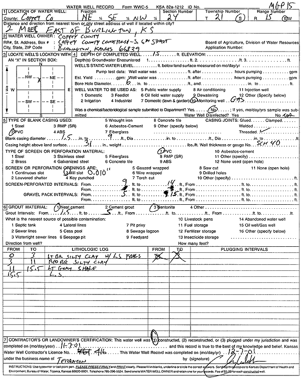
T21S, R15E, Sec. 24 SE SE NW |
Coffey County | 20.1 ft. | Monitoring well/observation/piezometer | MGP 12 | Constructed | 07-Nov-2001 | Scan | ||
|
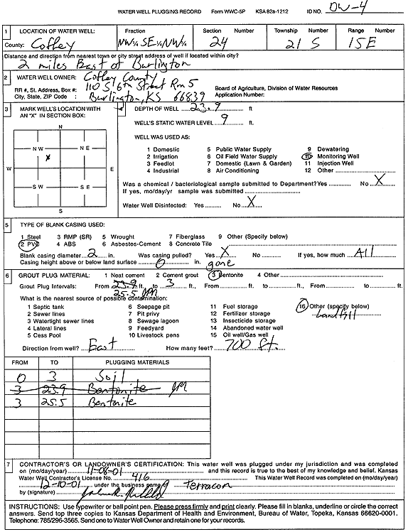
T21S, R15E, Sec. 24 NW SE NW |
Coffey County | 23.9 ft. | 9 ft. | Monitoring well/observation/piezometer | DW 4 | Plugged | 08-Nov-2001 | Scan | |
|
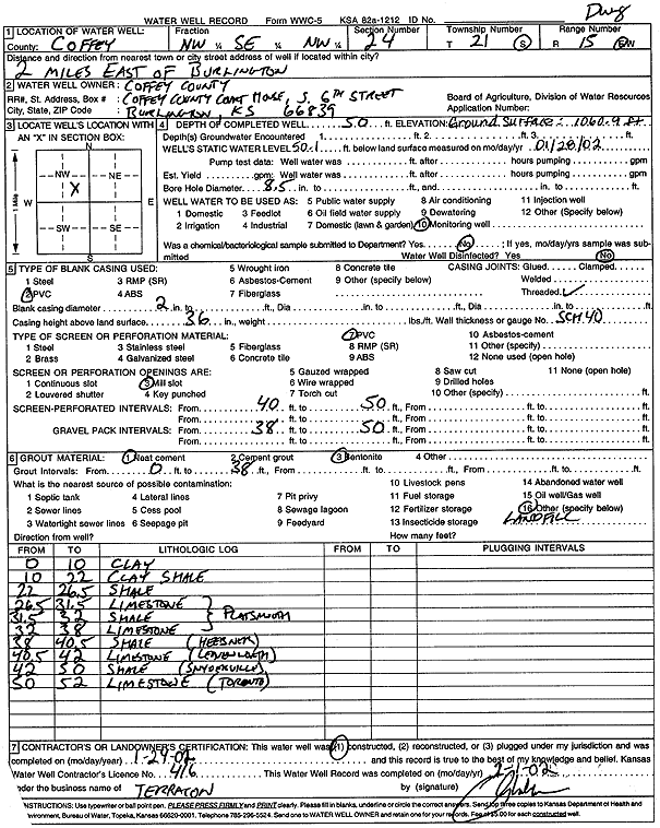
T21S, R15E, Sec. 24 NW SE NW |
Coffey County | 50 ft. | 50.1 ft. | Monitoring well/observation/piezometer | DW 8 | Constructed | 24-Jan-2002 | Scan | |
| View page: 1 || 2 || 3 || 4 || 5 || 6 || 7 || 8 || 9 || 10 || Next > | |||||||||