Select location of well to view details.
Click on column heading to sort.
|
|
|
County: Finney Select location of well to view details. Click on column heading to sort. |
|
|
|
| View page: < Prev || 101 || 102 || 103 || 104 || 105 || 106 || 107 || 108 || 109 || 110 | |||||||||
| T-R-S | Owner | Well Depth Ascend. Desc. |
Static Water Level Ascend. Desc. |
Est. Yield Ascend. Desc. |
Well Use | Other ID | Action Taken | Completion Date Ascend. Desc. |
Scan? |
|
T26S, R34W, Sec. 13 NE SW SE |
Wheatland Electric Coop | 605 ft. | 235 ft. | Irrigation | test 1 | Constructed | 12-May-2010 | ||
|
T26S, R34W, Sec. 13 SW |
Wheatland Water Treatment | 266 ft. | 72 ft. | Irrigation | Plugged | 19-Jul-2010 | |||
|
T26S, R34W, Sec. 14 C SW |
Lockwood, Larry | 370 ft. | 115 ft. | 1451 gpm. | Irrigation | Constructed | 12-Sep-1976 | Scan | |
|
T26S, R34W, Sec. 14 NW NW SE |
Lockwood, Larry | 269 ft. | Domestic, Livestock | Constructed | 17-Jun-1977 | Scan | |||
|
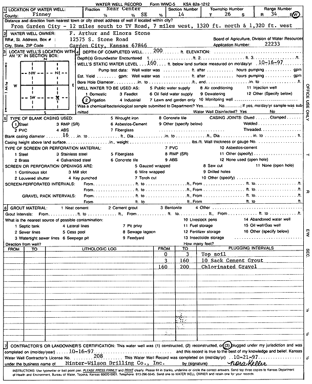
T26S, R34W, Sec. 14 NC SE |
Stone, F. Arthur and Elnora | 200 ft. | 160 ft. | Irrigation | Plugged | 16-Oct-1997 | Scan | ||
|
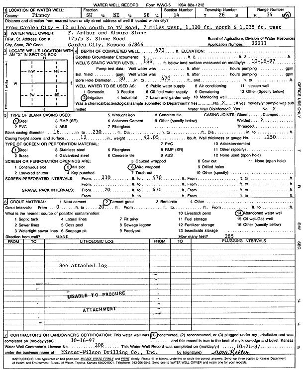
T26S, R34W, Sec. 14 SW NE SE |
Stone, F. Arthur and Elnora | 470 ft. | 166 ft. | Irrigation | Constructed | 16-Oct-1997 | Scan | ||
|
T26S, R34W, Sec. 15 SE NW NW |
Sandhill Enterprises Inc. | 565 ft. | 303 ft. | Irrigation | Constructed | 01-Jun-2023 |
KOLAR |
||
|
T26S, R34W, Sec. 15 NE |
SCS Farms | 314 ft. | 119 ft. | 1525 gpm. | Irrigation | Constructed | 29-Feb-1980 | Scan | |
|
T26S, R34W, Sec. 15 SE SE NW NW |
SCS Farms | 358 ft. | 117 ft. | 1500 gpm. | Irrigation | Constructed | 29-Feb-1980 | Scan | |
|
T26S, R34W, Sec. 16 NW |
Reeve, M. P. | 265 ft. | 108 ft. | 1500 gpm. | Irrigation | Constructed | 29-Apr-1979 | Scan | |
|
T26S, R34W, Sec. 16 SW SE NE |
Reeve, M. P. | 348 ft. | 105 ft. | 1450 gpm. | Irrigation | Constructed | 10-Jan-1977 | Scan | |
|
T26S, R34W, Sec. 16 SW |
SCS Farms | 335 ft. | 110 ft. | 1600 gpm. | Irrigation | Constructed | 29-Feb-1980 | Scan | |
|
T26S, R34W, Sec. 16 SE |
SCS Farms | 295 ft. | 109 ft. | 1625 gpm. | Irrigation | Constructed | 29-Feb-1980 | Scan | |
|
T26S, R34W, Sec. 17 NW |
Koster, Duane | 320 ft. | 135 ft. | 1550 gpm. | Irrigation | Constructed | 04-Oct-1979 | Scan | |
|
T26S, R34W, Sec. 17 NE |
Koster, Duane | 361 ft. | 121 ft. | 1800 gpm. | Irrigation | Constructed | 31-Aug-1979 | Scan | |
|
T26S, R34W, Sec. 17 SW NE SE |
O'Neal, John | 351 ft. | 95 ft. | 1600 gpm. | Irrigation | Constructed | 13-Apr-1977 | Scan | |
|
T26S, R34W, Sec. 17 SW |
O'Neal, John | 305 ft. | 115 ft. | 1640 gpm. | Irrigation | Constructed | 28-Feb-1980 | Scan | |
|
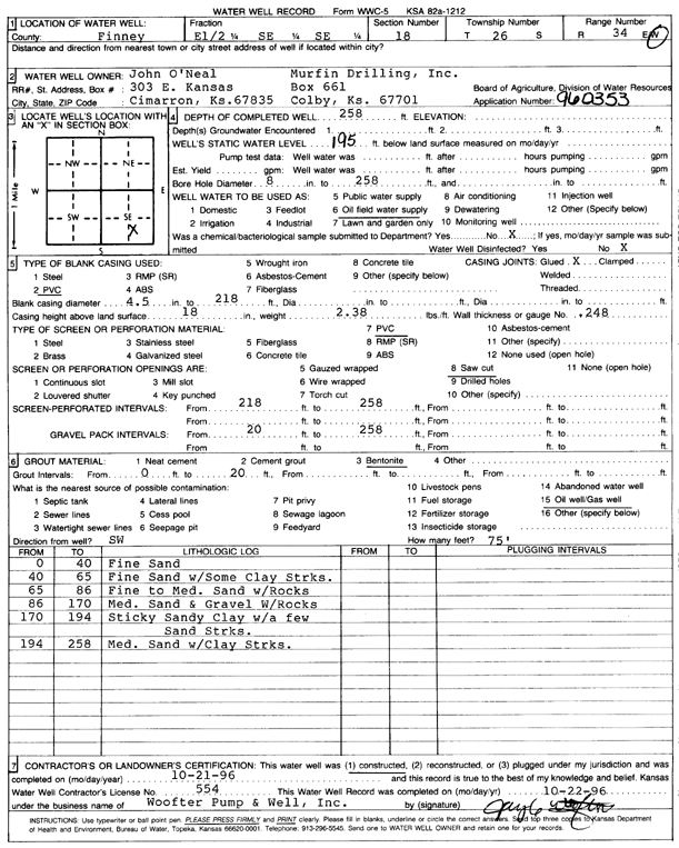
T26S, R34W, Sec. 18 E2 SE SE |
Murfin Drilling/O'Neal, John | 258 ft. | 195 ft. | Oil Field Water Supply | Constructed | 21-Oct-1996 | Scan | ||
|
T26S, R34W, Sec. 18 NE |
O'Neal, John | 335 ft. | 120 ft. | 1500 gpm. | Irrigation | Constructed | 03-Oct-1979 | Scan | |
|
T26S, R34W, Sec. 18 SE |
O'Neal, John | 385 ft. | 130 ft. | 1600 gpm. | Irrigation | Constructed | 03-Oct-1979 | Scan | |
|
T26S, R34W, Sec. 18 NW |
O'Neal, John | 335 ft. | 112 ft. | 1100 gpm. | Irrigation | Constructed | 30-Apr-1975 | Scan | |
|
T26S, R34W, Sec. 18 C SW SE |
Rains and Williamson Oil Co. | 220 ft. | 105 ft. | 50 gpm. | Oil Field Water Supply | USA D-7 | Constructed | 04-Mar-1977 | Scan |
|
T26S, R34W, Sec. 19 NE NW SE |
Cimarex Energy | 405 ft. | Monitoring well/observation/piezometer | 4 | Constructed | 05-Apr-2013 | |||
|
T26S, R34W, Sec. 19 NW SE NW |
Helmerich and Payne Inc. | 330 ft. | 149 ft. | Monitoring well/observation/piezometer | MW 1 | Constructed | 18-Jun-1987 | Scan | |
|
T26S, R34W, Sec. 19 NW SE NW |
Helmerich and Payne Inc. | 308 ft. | 150 ft. | Monitoring well/observation/piezometer | MW 2 | Constructed | 23-Jun-1987 | Scan | |
|
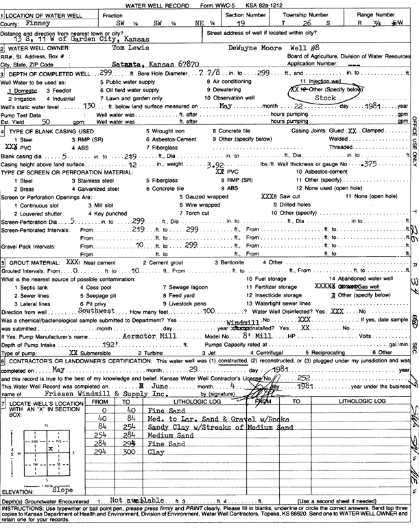
T26S, R34W, Sec. 19 SW SW NE |
Lewis, Tom | 299 ft. | 130 ft. | 50 gpm. | Domestic, Livestock | Constructed | 29-May-1981 | Scan | |
|
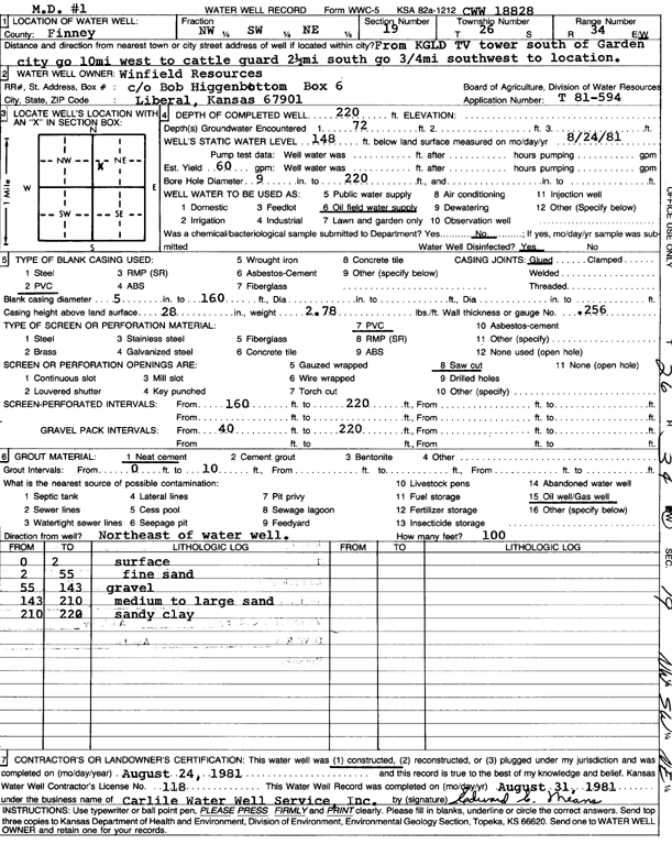
T26S, R34W, Sec. 19 NW SW NE |
Winfield Resources | 220 ft. | 148 ft. | Oil Field Water Supply | MD 1 | Constructed | 24-Aug-1981 | Scan | |
|
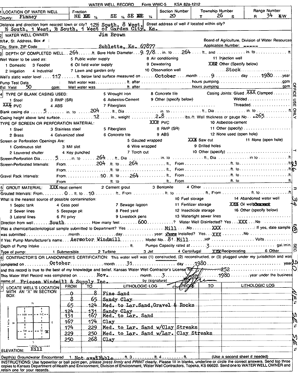
T26S, R34W, Sec. 20 NE SE SE |
Brown, Jim | 264 ft. | 117 ft. | 50 gpm. | Domestic, Livestock | Constructed | 31-Oct-1980 | Scan | |
|
T26S, R34W, Sec. 20 NW |
Helmerich and Payne Inc. | 154 ft. | 142 ft. | Monitoring well/observation/piezometer | Constructed | 20-Aug-1986 | Scan | ||
|
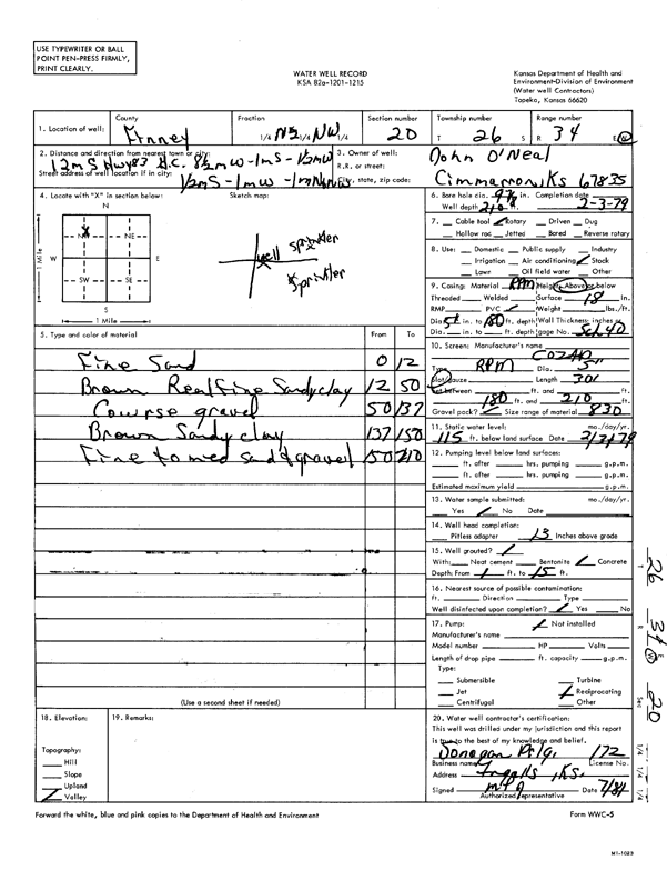
T26S, R34W, Sec. 20 N2 NW |
O'Neal, John | 210 ft. | 115 ft. | Domestic, Livestock | Constructed | 03-Feb-1979 | Scan | ||
|
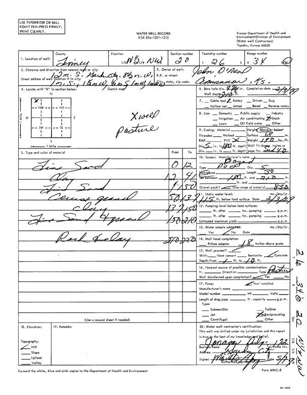
T26S, R34W, Sec. 20 N2 NW |
O'Neal, John | 210 ft. | 115 ft. | Domestic, Livestock | Constructed | 03-Feb-1979 | Scan | ||
|
T26S, R34W, Sec. 20 NW |
O'Neal, John | 303 ft. | 145 ft. | 1500 gpm. | Irrigation | Constructed | 30-May-1979 | Scan | |
|
T26S, R34W, Sec. 20 NW SE NE |
O'Neal, John | 255 ft. | 92 ft. | 1650 gpm. | Irrigation | Constructed | 10-Mar-1977 | Scan | |
|
T26S, R34W, Sec. 20 NE |
O'Neal, John | 260 ft. | 95 ft. | 1200 gpm. | Irrigation | Constructed | 08-Apr-1975 | Scan | |
|
T26S, R34W, Sec. 21 SE NW SE NW |
Sandyhill Enterprises LLC | 501 ft. | 302 ft. | 550 gpm. | Irrigation | Constructed | 02-Oct-2019 |
KOLAR |
|
|
T26S, R34W, Sec. 21 SW SW SE NE |
Sandyhill Enterprises LLC | 506 ft. | 260 ft. | 550 gpm. | Irrigation | Constructed | 24-Sep-2019 |
KOLAR |
|
|
T26S, R34W, Sec. 21 N |
SCS Farms | 305 ft. | 99 ft. | 1700 gpm. | Irrigation | Constructed | 29-Feb-1980 | Scan | |
|
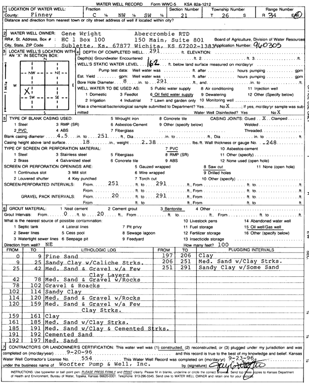
T26S, R34W, Sec. 21 C NW SW |
Wright, Gene | 291 ft. | 162 ft. | Oil Field Water Supply | Constructed | 20-Sep-1996 | Scan | ||
|
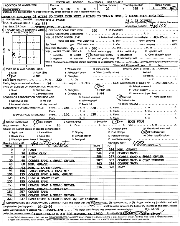
T26S, R34W, Sec. 22 W2 NW SW |
Helmerich and Payne Inc. | 320 ft. | Oil Field Water Supply | Oliver 1-22 | Constructed | 12-Mar-1996 | Scan | ||
|
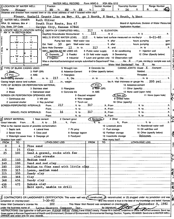
T26S, R34W, Sec. 22 NW NW SE |
Oliver, Ruth | 317 ft. | 112 ft. | 50 gpm. | Domestic | Constructed | 30-Jul-1982 | Scan | |
|
T26S, R34W, Sec. 22 SE SE NW |
Sandyhill Enterprises LLC | 610 ft. | 296 ft. | 750 gpm. | Irrigation | Constructed | 19-Jan-2026 |
KOLAR |
|
|
T26S, R34W, Sec. 22 SE SE NW NE |
Sandyhill Enterprises LLC | 591 ft. | 142 ft. | 700 gpm. | Irrigation | Constructed | 16-Oct-2018 |
KOLAR |
|
|
T26S, R34W, Sec. 22 NW |
SCS Farms | 335 ft. | 101 ft. | 1975 gpm. | Irrigation | Constructed | 29-Feb-1980 | Scan | |
|
T26S, R34W, Sec. 22 NE |
SCS Farms | 392 ft. | 120 ft. | 1400 gpm. | Irrigation | Constructed | 29-Feb-1980 | Scan | |
|
T26S, R34W, Sec. 22 NW NE NE |
Stone, Billy | 410 ft. | 192 ft. | Domestic | Constructed | 29-Oct-2004 | |||
|
T26S, R34W, Sec. 23 S2 S2 N2 NW |
Circle Land and Cattle | 468 ft. | 167 ft. | 1205 gpm. | Irrigation | Constructed | 02-May-1996 | ||
|
T26S, R34W, Sec. 23 SE SE NE |
Duane E Koster Trust | 435 ft. | 262 ft. | Irrigation | Test 5 | Constructed | 04-Nov-2011 | ||
|
T26S, R34W, Sec. 23 NE |
Duane E. Koster Trust | 299 ft. | 260 ft. | Irrigation | Plugged | 04-Nov-2011 | |||
|
T26S, R34W, Sec. 23 SW |
Duane Koster Farms | 330 ft. | 270 ft. | Irrigation | Plugged | 02-Sep-2011 | |||
|
T26S, R34W, Sec. 23 SW |
Duane Koster Farms | 460 ft. | 269 ft. | Irrigation | Test 3 | Constructed | 02-Sep-2011 | ||
| View page: < Prev || 101 || 102 || 103 || 104 || 105 || 106 || 107 || 108 || 109 || 110 | |||||||||