Select location of well to view details.
Click on column heading to sort.
|
|
|
County: Finney Select location of well to view details. Click on column heading to sort. |
|
|
|
| View page: < Prev || 91 || 92 || 93 || 94 || 95 || 96 || 97 || 98 || 99 || 100 || Next > | |||||||||
| T-R-S | Owner | Well Depth Ascend. Desc. |
Static Water Level Ascend. Desc. |
Est. Yield Ascend. Desc. |
Well Use | Other ID | Action Taken | Completion Date Ascend. Desc. |
Scan? |
|
T25S, R34W, Sec. 35 SE NW SE |
Wheatland Electric Cooperative | 385 ft. | 220 ft. | Public Water Supply | Constructed | 15-May-2009 | |||
|
T25S, R34W, Sec. 35 SW NE NW |
Wheatland Electric Cooperative | 422 ft. | 231 ft. | Public Water Supply | Constructed | 08-Jun-2009 | |||
|
T25S, R34W, Sec. 35 SE |
Wheatland Water Treatment | 315 ft. | 230 ft. | Public Water Supply | Plugged | 23-Nov-2010 | |||
|
T25S, R34W, Sec. 35 NW |
Wheatland Water Treatment | 320 ft. | 228 ft. | (unstated)/abandoned | Plugged | 23-Nov-2010 | |||
|
T25S, R34W, Sec. 36 SE NW SW |
J.O. Cattle Co. | 470 ft. | 162 ft. | Irrigation | Constructed | 12-Feb-1998 | Scan | ||
|
T25S, R34W, Sec. 36 SE |
Jones, Taylor | 471 ft. | 96 ft. | 1600 gpm. | Irrigation | Constructed | 28-Feb-1979 | Scan | |
|
T25S, R34W, Sec. 36 SE SE SW SE |
Neufeld, Jacob | 410 ft. | 265 ft. | 35 gpm. | Domestic, Livestock | Constructed | 17-Oct-2014 |
KOLAR |
|
|
T25S, R34W, Sec. 36 SE NW NW |
Wheatland Electric Cooperative | 484 ft. | 211 ft. | Public Water Supply | Constructed | 08-Jun-2009 | |||
|
T25S, R34W, Sec. 36 NW |
Wheatland Water Treatment | 280 ft. | 210 ft. | Public Water Supply | Plugged | 30-Nov-2010 | |||
|
T25S, R34W, Sec. 36 SW |
Wheatland Water Treatment | 470 ft. | 162 ft. | Public Water Supply | Plugged | 20-Nov-2010 | |||
|
T25S, R34W, Sec. 36 C N2 SW |
Wheatland Water Treatment | 483 ft. | 219 ft. | Industrial | Well 11 | Constructed | 10-Jul-2008 | ||
|
T26S, R31W, Sec. 1 NE NE SW |
Husband, Bob | 270 ft. | Irrigation | Constructed | 03-Apr-2012 | ||||
|
T26S, R31W, Sec. 1 NE SE SE |
Husband, Bob | 295 ft. | 143 ft. | Irrigation | Constructed | 24-Jan-2003 | Scan | ||
|
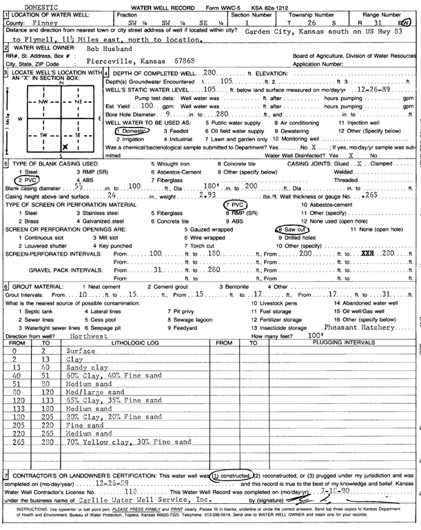
T26S, R31W, Sec. 1 SW SW SE |
Husband, Bob | 280 ft. | 105 ft. | 100 gpm. | Domestic | Constructed | 26-Dec-1989 | Scan | |
|
T26S, R31W, Sec. 1 SE SE SW |
Klassen, John | 325 ft. | 193 ft. | Domestic | Constructed | 28-Jun-2022 |
KOLAR |
||
|
T26S, R31W, Sec. 1 NE NE SE |
TRL Land | 314 ft. | 205 ft. | Irrigation | Constructed | 19-Mar-2026 |
KOLAR |
||
|
T26S, R31W, Sec. 1 NE NE SW |
TRL Land Co LLC | 288 ft. | 270 ft. | Irrigation | Constructed | 14-Jul-2024 |
KOLAR |
||
|
T26S, R31W, Sec. 2 NW |
Corley, Dale | 284 ft. | 67 ft. | 1600 gpm. | Irrigation | Constructed | 11-May-1976 | Scan | |
|
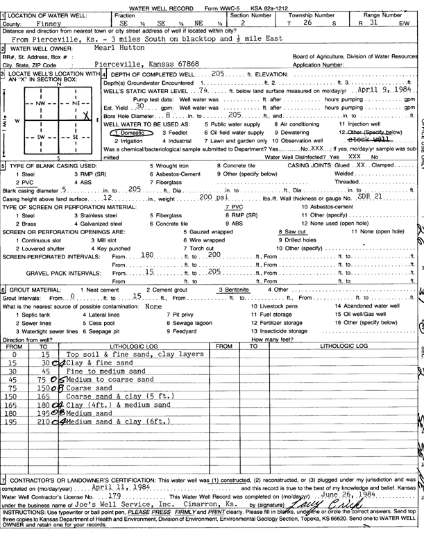
T26S, R31W, Sec. 2 SE SE NE |
Hutton, Mearl | 205 ft. | 74 ft. | 30 gpm. | Domestic | Constructed | 11-Apr-1984 | Scan | |
|
T26S, R31W, Sec. 2 NE SE NE |
Rieth, Wayne | 299 ft. | 118 ft. | Domestic | Constructed | 18-May-1998 | Scan | ||
|
T26S, R31W, Sec. 3 NW NW NW |
McGraw, Alma L. | 220 ft. | 101 ft. | Irrigation | Constructed | 05-Apr-1996 | Scan | ||
|
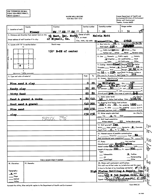
T26S, R31W, Sec. 3 NW SE SW |
Mott, Melvin | 238 ft. | 40 ft. | 1600 gpm. | Irrigation | Constructed | 03-May-1976 | Scan | |
|
T26S, R31W, Sec. 3 SE SE SW |
Mott, Melvin | 270 ft. | 70 ft. | 25 gpm. | Domestic | Constructed | 10-Sep-1986 | Scan | |
|
T26S, R31W, Sec. 3 SE SW SW |
Mott, Melvin and Myrna | 270 ft. | 160 ft. | Irrigation | Test 3 | Constructed | 11-Jul-2006 | ||
|
T26S, R31W, Sec. 4 C SW |
McGraw, Lowell | 295 ft. | 93 ft. | 1700 gpm. | Irrigation | Constructed | 06-Jun-1986 | Scan | |
|
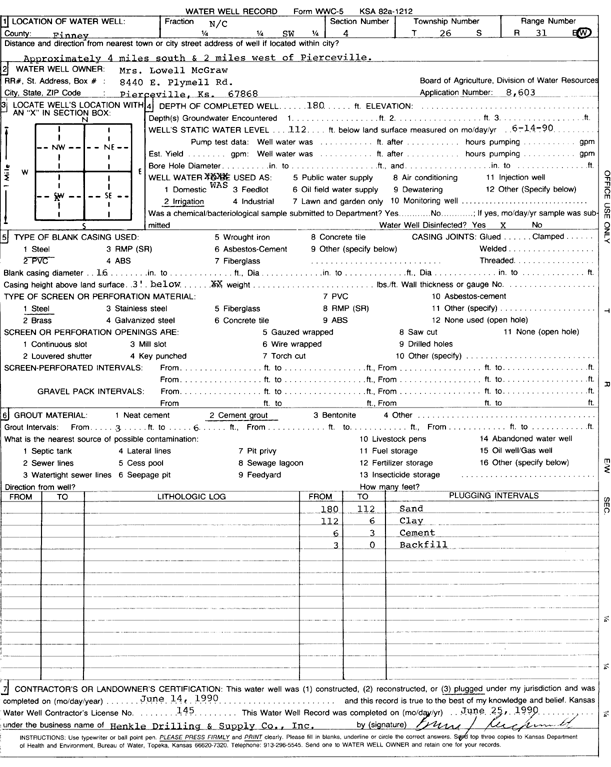
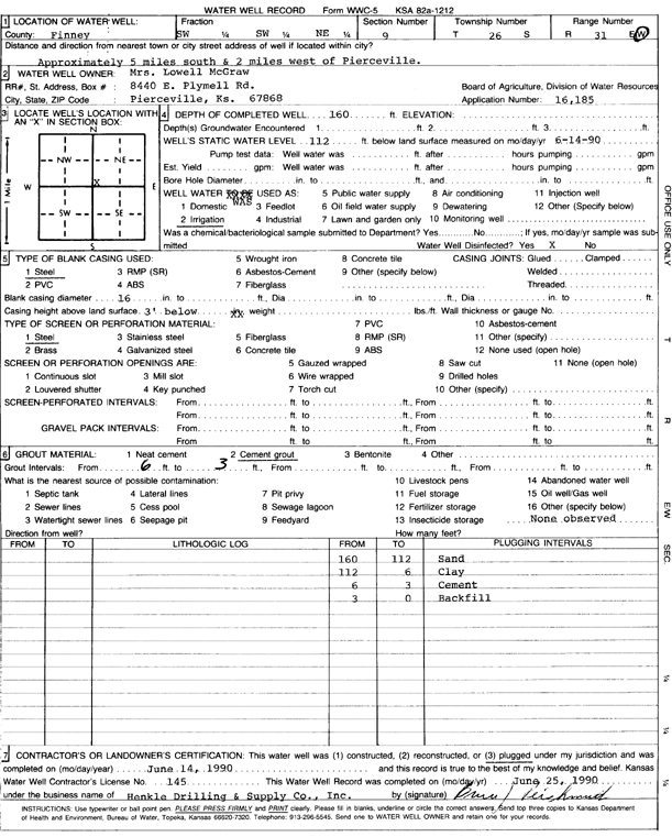
T26S, R31W, Sec. 4 C SW |
McGraw, Mrs. Lowell | 180 ft. | 112 ft. | Irrigation | Plugged | 14-Jun-1990 | Scan | ||
|
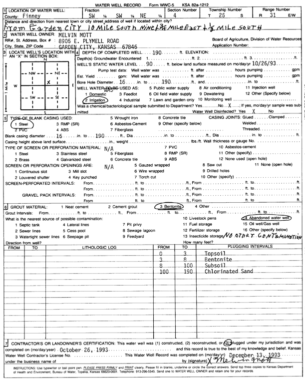
T26S, R31W, Sec. 4 SW SW NE |
Mott, Melvin | 190 ft. | 90 ft. | Irrigation | Plugged | 26-Oct-1993 | Scan | ||
|
T26S, R31W, Sec. 4 SW NE SE |
Mott, Melvin | 231 ft. | 116 ft. | Irrigation | Constructed | 14-Apr-2000 | Scan | ||
|
T26S, R31W, Sec. 4 SE SE SE |
Mott, Melvin | 280 ft. | 150 ft. | Domestic | Constructed | 10-Aug-2006 | |||
|
T26S, R31W, Sec. 4 NE |
Mott, Melvin | 213 ft. | 94 ft. | 800 gpm. | Irrigation | Constructed | 17-Mar-1993 | Scan | |
|
T26S, R31W, Sec. 4 NW NE |
Mott, Melvin and Myrna | 310 ft. | 123 ft. | Irrigation | Constructed | 04-Mar-2004 | Scan | ||
|
T26S, R31W, Sec. 5 SW NE SE |
Mott, Ronald | 265 ft. | 62 ft. | 1200 gpm. | Irrigation | Constructed | 18-Aug-1975 | Scan | |
|
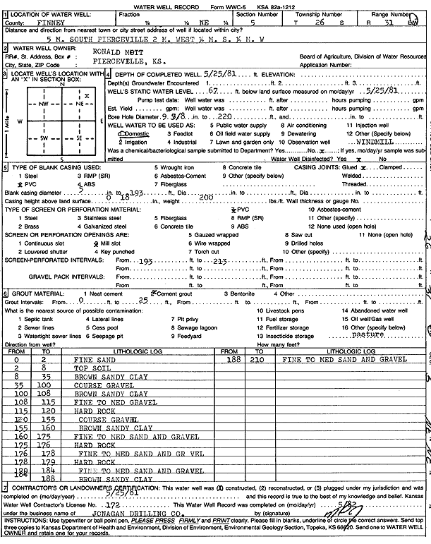
T26S, R31W, Sec. 5 NE |
Mott, Ronald | 210 ft. | 67 ft. | Domestic | Constructed | 25-May-1981 | Scan | ||
|
T26S, R31W, Sec. 6 NW NW |
Donald/W. Laurene Vanderree Trusts | 350 ft. | 146 ft. | Irrigation | Constructed | 27-Jun-2008 | |||
|
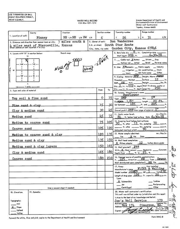
T26S, R31W, Sec. 6 NE NE NW |
Vanderree, Don | 209 ft. | 84 ft. | 90 gpm. | Domestic | Constructed | 30-Jun-1978 | Scan | |
|
T26S, R31W, Sec. 6 NW NE NW |
Villaines, Daryl | 365 ft. | 130 ft. | Domestic | Constructed | 20-Feb-2024 |
KOLAR |
||
|
T26S, R31W, Sec. 8 NE NE NE NW |
Lightner, Lloyd | 305 ft. | 199 ft. | 16 gpm. | Domestic | Reconstructed | 23-Aug-2021 |
KOLAR |
|
|
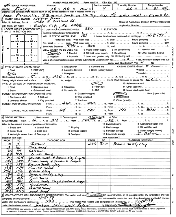
T26S, R31W, Sec. 9 NE NE NW |
Lightner Farms | 300 ft. | 137 ft. | Domestic | Constructed | 05-Apr-1999 | Scan | ||
|
T26S, R31W, Sec. 9 C NW |
McGraw, Doug | 290 ft. | 93 ft. | Irrigation | Constructed | 23-Mar-1989 | Scan | ||
|
T26S, R31W, Sec. 9 SE |
McGraw, Lowell | 304 ft. | 85 ft. | 1460 gpm. | Irrigation | Constructed | 15-Mar-1982 | Scan | |
|
T26S, R31W, Sec. 9 NE SW NE |
McGraw, Lowell | 290 ft. | 57 ft. | 1550 gpm. | Irrigation | Constructed | 30-Jul-1976 | Scan | |
|
T26S, R31W, Sec. 9 SW SW NE |
McGraw, Mrs. Lowell | 160 ft. | 112 ft. | Irrigation | Plugged | 14-Jun-1990 | Scan | ||
|
T26S, R31W, Sec. 10 NW SE NE |
Bar O Bar Ranch | 270 ft. | 140 ft. | Irrigation | Constructed | 19-Sep-2003 | Scan | ||
|
T26S, R31W, Sec. 10 NW NE NW |
Mott, Ron | 256 ft. | 179 ft. | Domestic | Constructed | 19-Jul-2009 | |||
|
T26S, R31W, Sec. 10 SW NE SW |
Mott, Ronald | 290 ft. | 66 ft. | 1425 gpm. | Irrigation | Constructed | 10-Aug-1976 | Scan | |
|
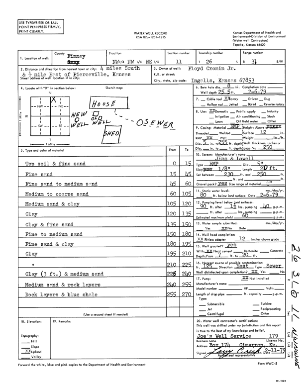
T26S, R31W, Sec. 11 NW NW NE |
Cronin Jr., Floyd | 255 ft. | 80 ft. | 60 gpm. | Domestic | Constructed | 06-Feb-1979 | Scan | |
|
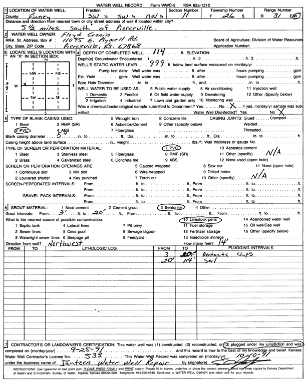
T26S, R31W, Sec. 11 SW SW NW |
Cronin, Floyd | 114 ft. | Domestic | Plugged | 25-Sep-1991 | Scan | |||
|
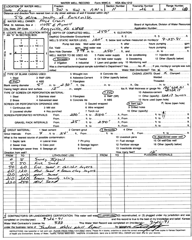
T26S, R31W, Sec. 11 SW SW NW |
Cronin, Floyd | 250 ft. | 120 ft. | Domestic | Constructed | 26-Sep-1991 | Scan | ||
|
T26S, R31W, Sec. 11 SE SW SE SE |
Husband, Bob and Kathy | 291 ft. | 230 ft. | 425 gpm. | Irrigation | Constructed | 16-Aug-2021 |
KOLAR |
|
|
T26S, R31W, Sec. 12 SW SW SE SE |
Husband, Bob and Kathy | 350 ft. | 214 ft. | 1003 gpm. | Irrigation | Constructed | 21-Jun-2016 |
KOLAR |
|
| View page: < Prev || 91 || 92 || 93 || 94 || 95 || 96 || 97 || 98 || 99 || 100 || Next > | |||||||||