Select location of well to view details.
Click on column heading to sort.
|
|
|
County: Graham Select location of well to view details. Click on column heading to sort. |
|
|
|
| View page: 1 || 2 || 3 || 4 || 5 || 6 || 7 || 8 || 9 || 10 || Next > | |||||||||
| T-R-S | Owner | Well Depth Ascend. Desc. |
Static Water Level Ascend. Desc. |
Est. Yield Ascend. Desc. |
Well Use | Other ID | Action Taken | Completion Date Ascend. Desc. |
Scan? |
|
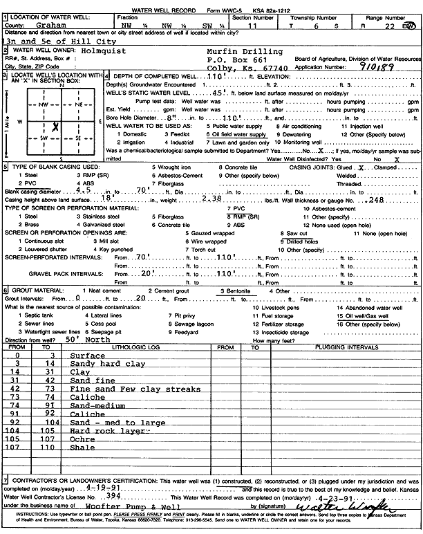
T6S, R22W, Sec. 11 NW NW SW |
Murfin Drilling Co. | 110 ft. | 45 ft. | Oil Field Water Supply | Constructed | 19-Apr-1991 | Scan | ||
|
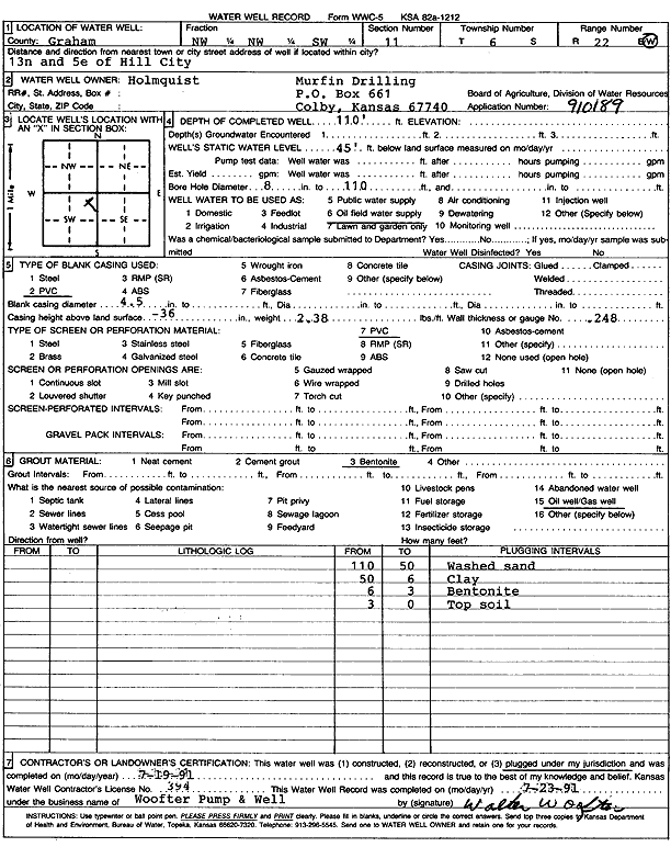
T6S, R22W, Sec. 11 NW NW SW |
Murfin Drilling Co. | 110 ft. | 45 ft. | Oil Field Water Supply | Plugged | 19-Jul-1991 | Scan | ||
|
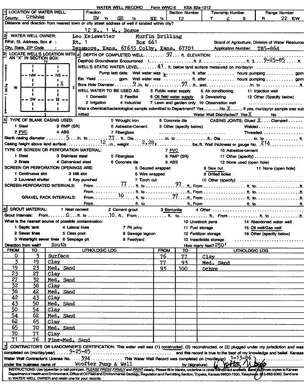
T6S, R22W, Sec. 12 SW SE NE |
Leo Keiswetter/Murfin Drilling Co. | 97 ft. | 41 ft. | Oil Field Water Supply | Constructed | 25-Sep-1985 | Scan | ||
|
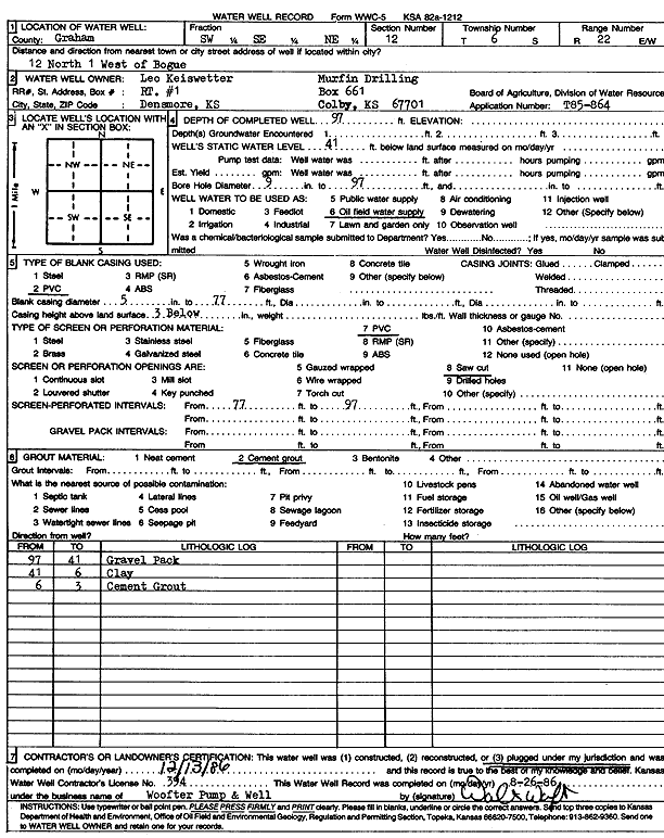
T6S, R22W, Sec. 12 SW SE NE |
Leo Keiswetter/Murfin Drilling Co. | 97 ft. | 41 ft. | Oil Field Water Supply | Plugged | 13-Dec-1986 | Scan | ||
|
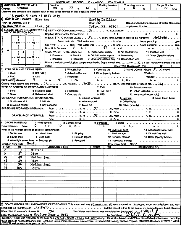
T6S, R22W, Sec. 12 NE NE SW |
Mike Ary/Murfin Drilling Co. | 97 ft. | 27 ft. | Oil Field Water Supply | Constructed | 28-Apr-1986 | Scan | ||
|
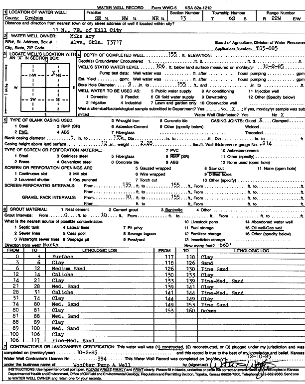
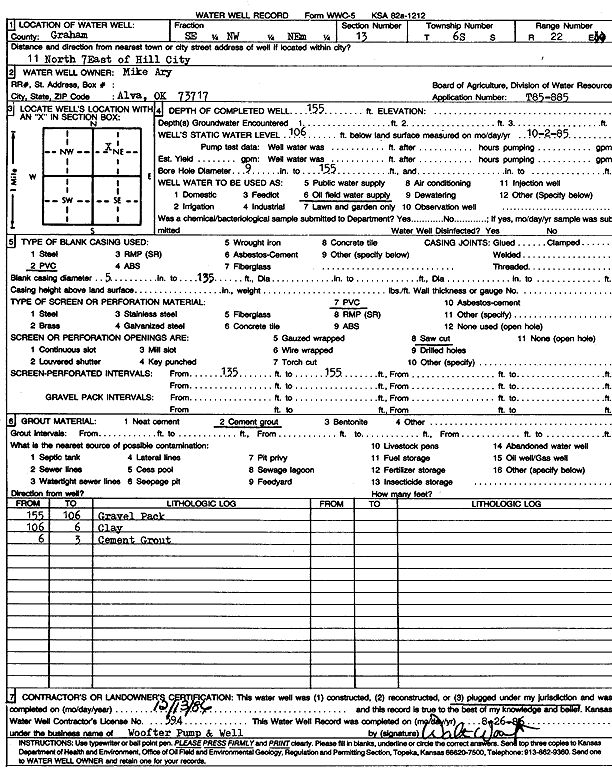
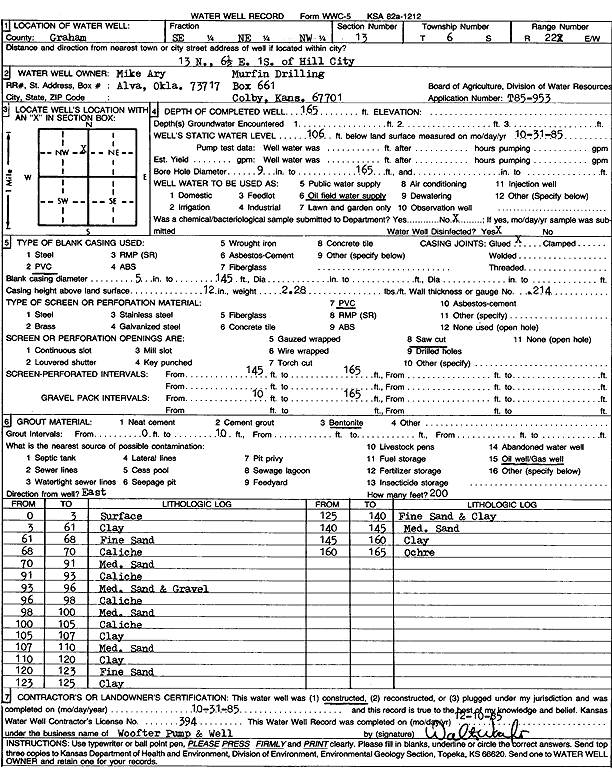
T6S, R22W, Sec. 13 SE NW NE |
Ary, Mike | 155 ft. | 106 ft. | Oil Field Water Supply | Constructed | 02-Oct-1985 | Scan | ||
|
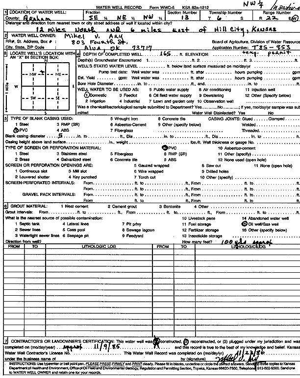
T6S, R22W, Sec. 13 SE NE NW |
Ary, Mike | 165 ft. | Domestic | Reconstructed | 09-Nov-1985 | Scan | |||
|
T6S, R22W, Sec. 13 SE NW NE |
Ary, Mike | 155 ft. | 106 ft. | Oil Field Water Supply | Plugged | 13-Dec-1986 | Scan | ||
|
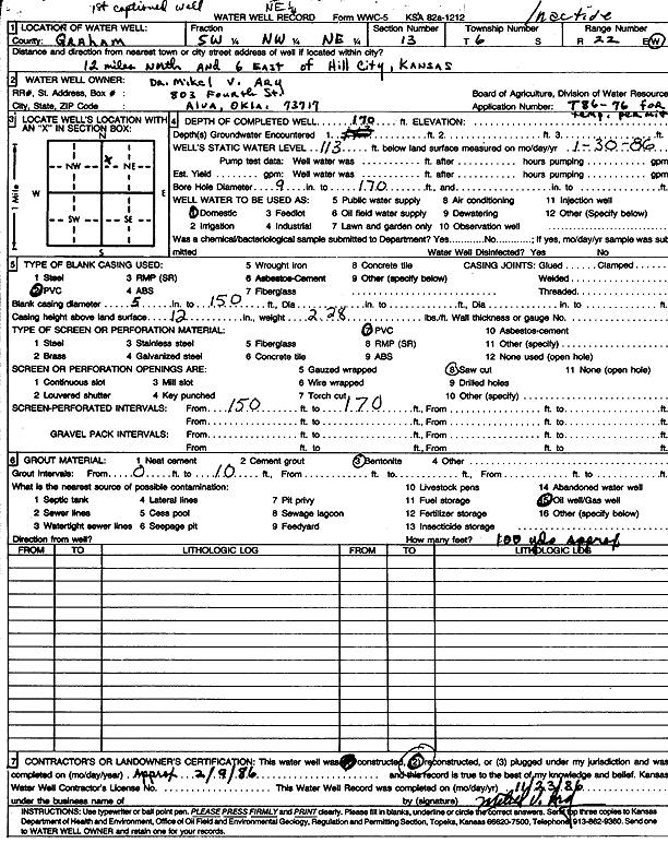
T6S, R22W, Sec. 13 SW NW NE |
Ary, Mike | 170 ft. | 113 ft. | Domestic | Reconstructed | 09-Feb-1986 | Scan | ||
|
T6S, R22W, Sec. 13 SE NE NW |
Ary, Mike/Murfin Drilling | 165 ft. | 106 ft. | Oil Field Water Supply | Constructed | 31-Oct-1985 | Scan | ||
|
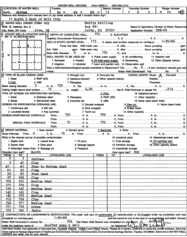
T6S, R22W, Sec. 13 SW NW NE |
Ary, Mike/Murfin Drilling Co. | 170 ft. | 113 ft. | Oil Field Water Supply | Constructed | 30-Jan-1986 | Scan | ||
|
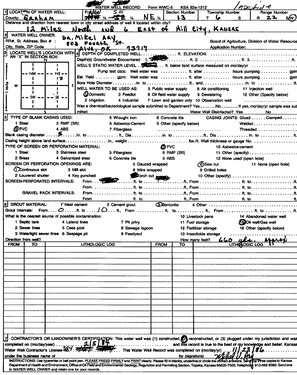
T6S, R22W, Sec. 13 NW SE NE |
Ary, Mikel | Domestic | Reconstructed | 05-Feb-1984 | Scan | ||||
|
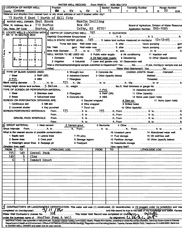
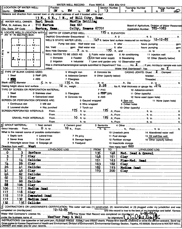
T6S, R22W, Sec. 13 SW NW SW |
Brock, Earl/Murfin Drilling Co. | 195 ft. | 149 ft. | Oil Field Water Supply | Plugged | 11-Mar-1986 | Scan | ||
|
T6S, R22W, Sec. 13 SW NW SW |
Brock, Earl/Murfin Drilling Co. | 195 ft. | 149 ft. | Oil Field Water Supply | Constructed | 12-Dec-1985 | Scan | ||
|
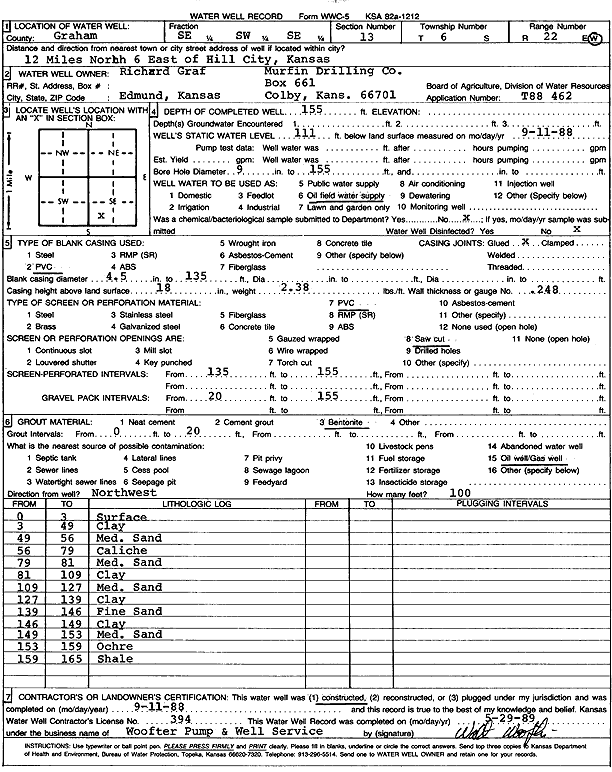
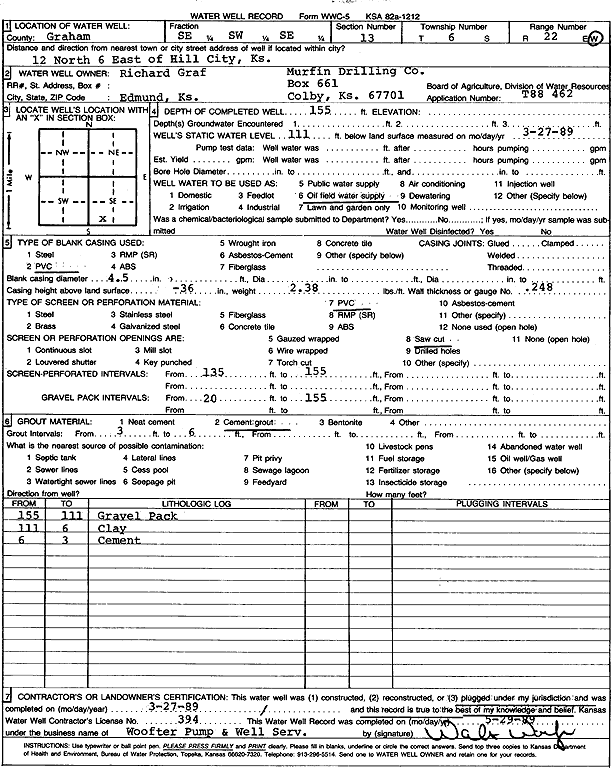
T6S, R22W, Sec. 13 SE SW SE |
Graf, Richard/Murfin Drilling Co. | 155 ft. | 111 ft. | Oil Field Water Supply | Constructed | 11-Sep-1988 | Scan | ||
|
T6S, R22W, Sec. 13 SE SW SE |
Graf, Richard/Murfin Drilling Co. | 155 ft. | 111 ft. | Oil Field Water Supply | Plugged | 27-Mar-1989 | Scan | ||
|
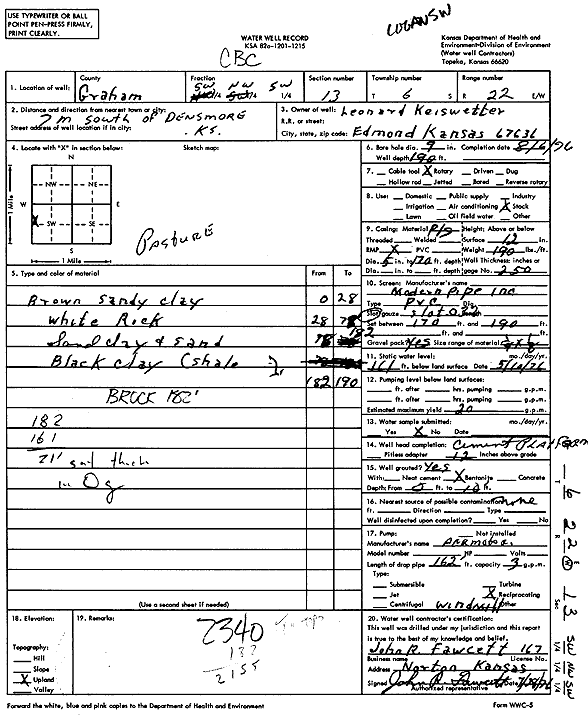
T6S, R22W, Sec. 13 SW NW SW |
Keiswetter, Leonard | 190 ft. | 161 ft. | 20 gpm. | Domestic, Livestock | Constructed | 06-Aug-1976 | Scan | |
|
T6S, R22W, Sec. 13 NE SW SE SE |
Worcester, Allen and Dorothy (was Ritchie Expl) | 130 ft. | Domestic, changed from Oil Field Water Supply | Constructed | 17-Feb-2011 | ||||
|
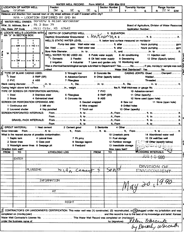
T6S, R22W, Sec. 13 SW SE SE |
Worcester, Dorothy and Allen | Domestic | Plugged | 20-May-1990 | Scan | ||||
|
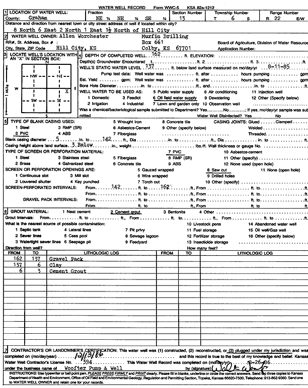
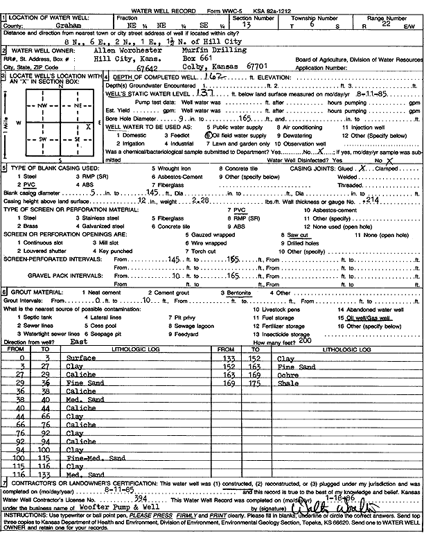
T6S, R22W, Sec. 13 NE NE SE |
Worchester, Allen/Murfin Drilling Co. | 162 ft. | 137 ft. | Oil Field Water Supply | Plugged | 13-Dec-1986 | Scan | ||
|
T6S, R22W, Sec. 13 NE NE SE |
Worchester, Allen/Murfin Drilling Co. | 162 ft. | 137 ft. | Oil Field Water Supply | Constructed | 11-Aug-1985 | Scan | ||
|
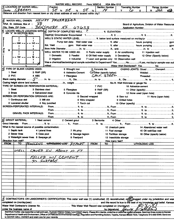
T6S, R22W, Sec. 14 SE SE SE |
Pakkabier, Henry | (unstated)/abandoned | Plugged | Scan | |||||
|
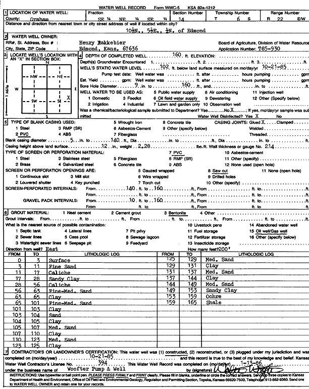
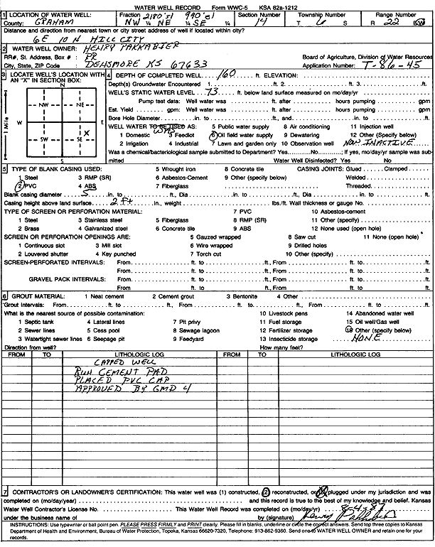
T6S, R22W, Sec. 14 SE NE SE |
Pakkabier, Henry | 160 ft. | 102 ft. | Oil Field Water Supply | Constructed | 21-Oct-1985 | Scan | ||
|
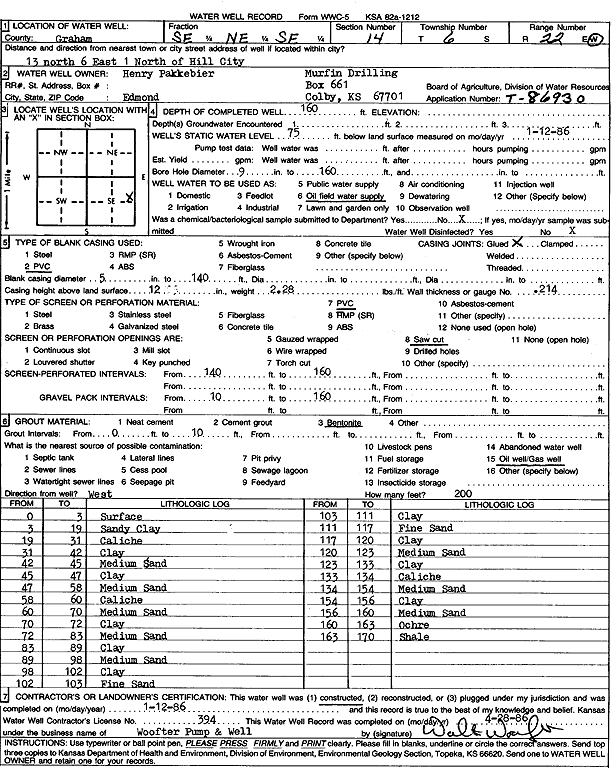
T6S, R22W, Sec. 14 NW NE SE |
Pakkabier, Henry | 160 ft. | 75 ft. | Oil Field Water Supply | Constructed | 12-Jan-1986 | Scan | ||
|
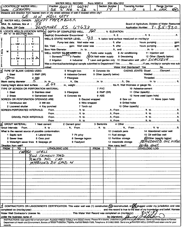
T6S, R22W, Sec. 14 SE NE SE |
Pakkabier, Henry | 160 ft. | 93 ft. | Oil Field Water Supply | Plugged | 04-Aug-1987 | Scan | ||
|
T6S, R22W, Sec. 14 NW NE SE |
Pakkabier, Henry | 160 ft. | 73 ft. | Oil Field Water Supply | Plugged | 04-Aug-1987 | Scan | ||
|
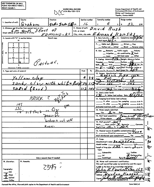
T6S, R22W, Sec. 16 SW SW SE |
David Rush | 146 ft. | 131 ft. | 12 gpm. | Domestic, Livestock | Constructed | 07-Jul-1976 | Scan | |
|
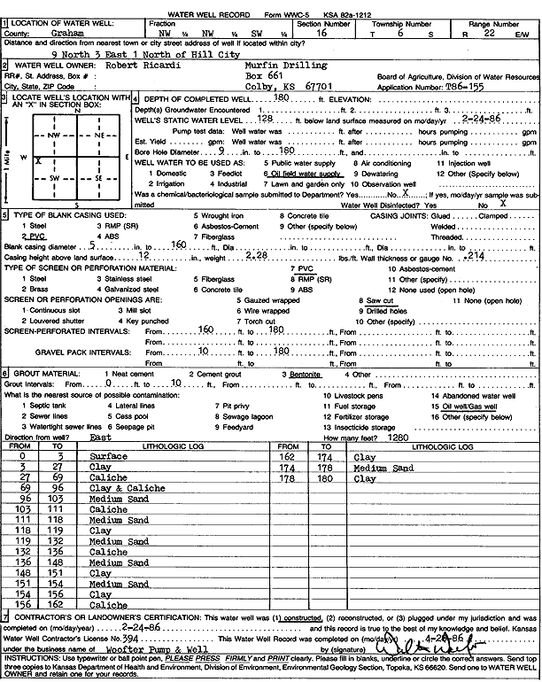
T6S, R22W, Sec. 16 NW NW SW |
Robert Ricardi/Murfin Drilling Co. | 180 ft. | 128 ft. | Oil Field Water Supply | Constructed | 24-Feb-1986 | Scan | ||
|
T6S, R22W, Sec. 16 W2 NW SW SE |
Trexler, Brad (was H&C Oil Operating, inc) | 210 ft. | Domestic, changed from Oil Field Water Supply | RET 16-1 | Constructed | 02-Feb-2012 | |||
|
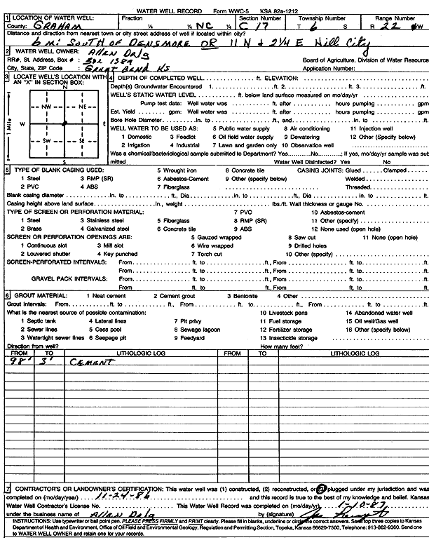
T6S, R22W, Sec. 17 C |
Allen Drilling Co. | (unstated)/abandoned | Plugged | 24-Nov-1986 | Scan | ||||
|
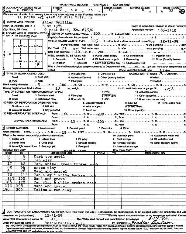
T6S, R22W, Sec. 17 NW SE SE |
Allen Drilling Co. | 200 ft. | 125 ft. | Oil Field Water Supply | Constructed | 31-Dec-1985 | Scan | ||
|
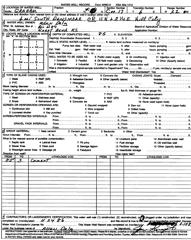
T6S, R22W, Sec. 17 C |
Allen Drilling Co. | 85 ft. | (unstated)/abandoned | Plugged | 24-Nov-1986 | Scan | |||
|
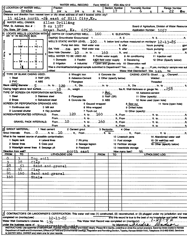
T6S, R22W, Sec. 17 SW SE SW |
Allen Drilling Co. | 160 ft. | 100 ft. | Oil Field Water Supply | Constructed | 13-Dec-1985 | Scan | ||
|
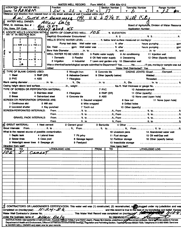
T6S, R22W, Sec. 17 SW SE SW |
Allen Drilling Co. | 105 ft. | (unstated)/abandoned | Plugged | 24-Nov-1986 | Scan | |||
|
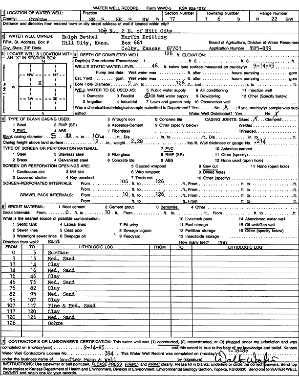
T6S, R22W, Sec. 17 SE SE NW |
Bethel, Ralph/Murfin Driling Co. | 126 ft. | 46 ft. | Oil Field Water Supply | Constructed | 14-Sep-1985 | Scan | ||
|
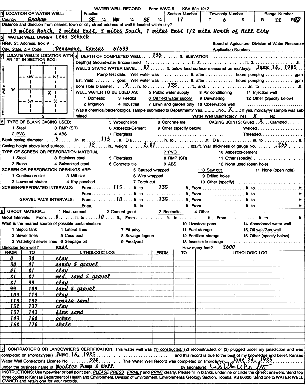
T6S, R22W, Sec. 17 SE NW SE |
Schuck, Lena | 135 ft. | 87 ft. | Oil Field Water Supply | Constructed | 16-Jun-1985 | Scan | ||
|
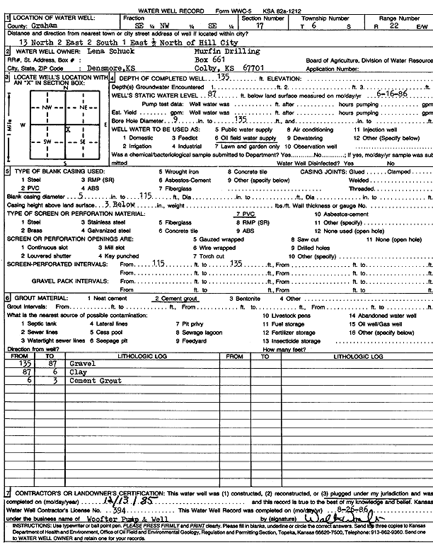
T6S, R22W, Sec. 17 SE NW SE |
Schuck, Lena/Murfin Drilling Co. | 135 ft. | 87 ft. | Oil Field Water Supply | Plugged | 13-Dec-1985 | Scan | ||
|
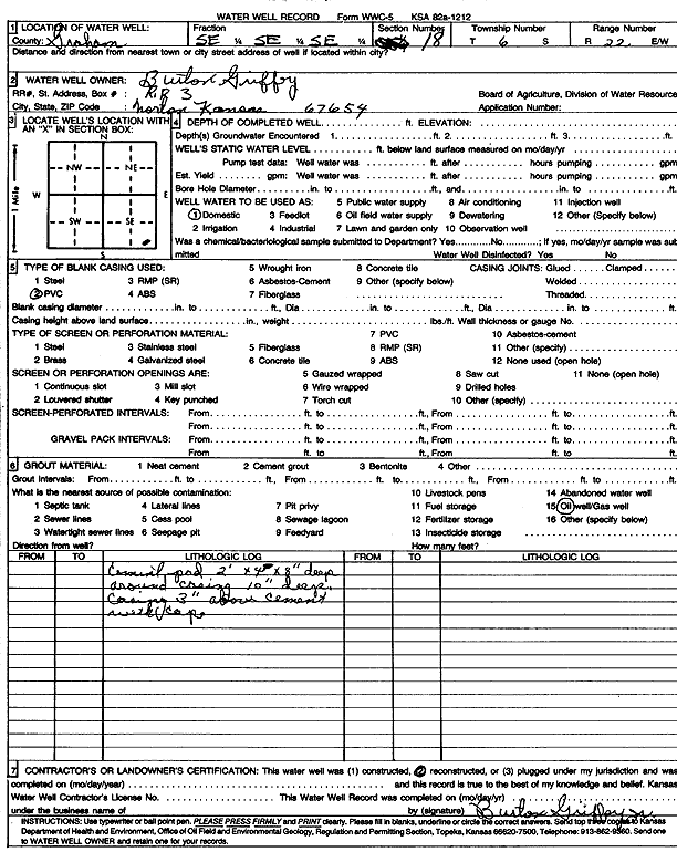
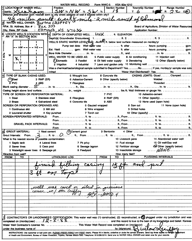
T6S, R22W, Sec. 18 SE SE SE |
Griffey, Burton | Domestic | Reconstructed | Scan | |||||
|
T6S, R22W, Sec. 18 SW NW SW |
Griffey, Burton | Domestic | Plugged | 08-Dec-1988 | Scan | ||||
|
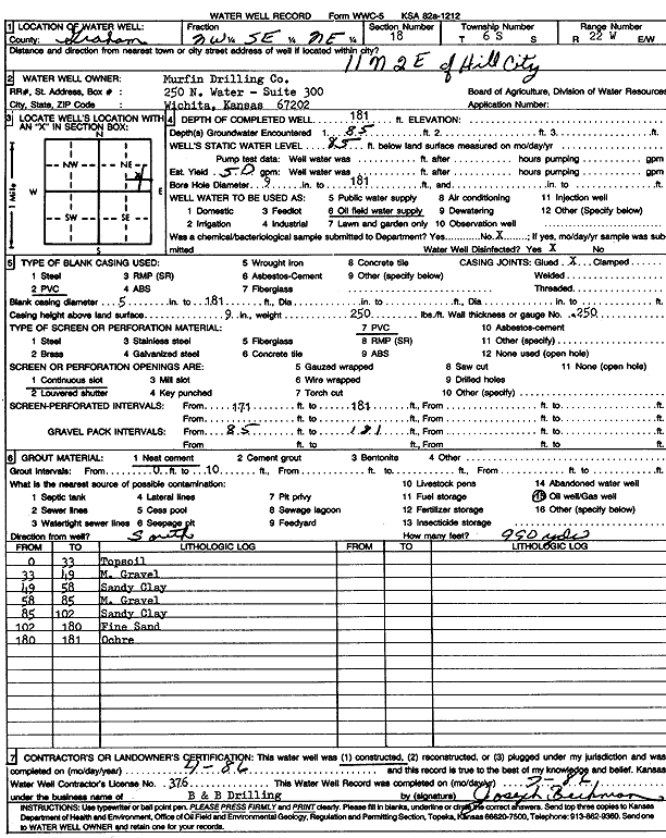
T6S, R22W, Sec. 18 NW SE NE |
Murfin Drilling Co. | 181 ft. | 85 ft. | 50 gpm. | Oil Field Water Supply | Constructed | 01-Apr-1986 | Scan | |
|
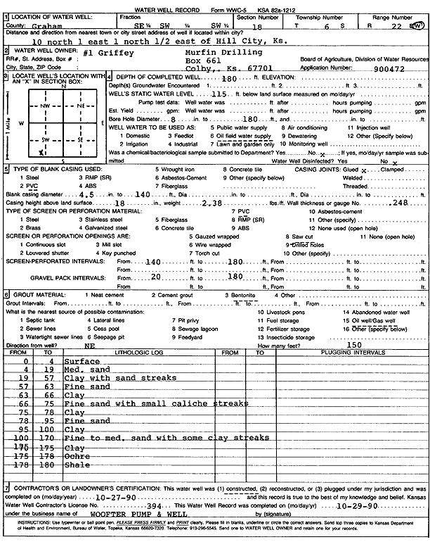
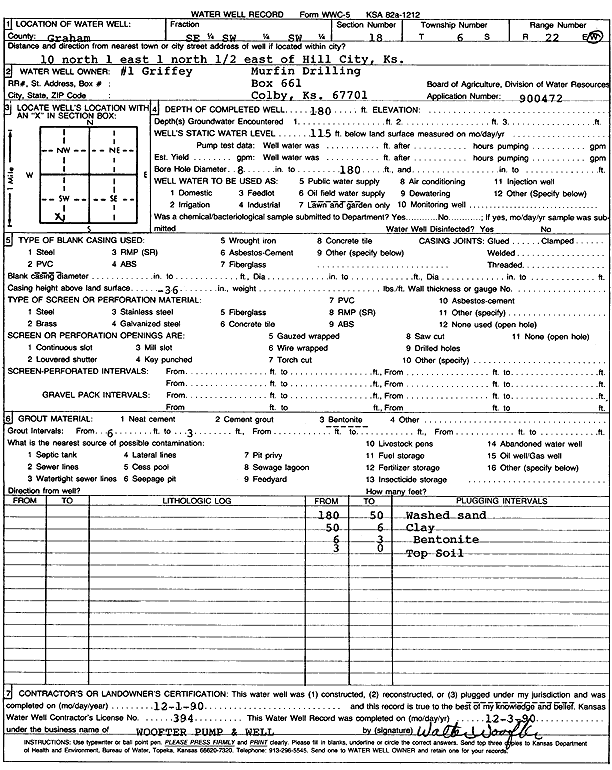
T6S, R22W, Sec. 18 SE SW SW |
Murfin Drilling Co. | 180 ft. | 115 ft. | Oil Field Water Supply | Griffey 1 | Constructed | 27-Oct-1990 | Scan | |
|
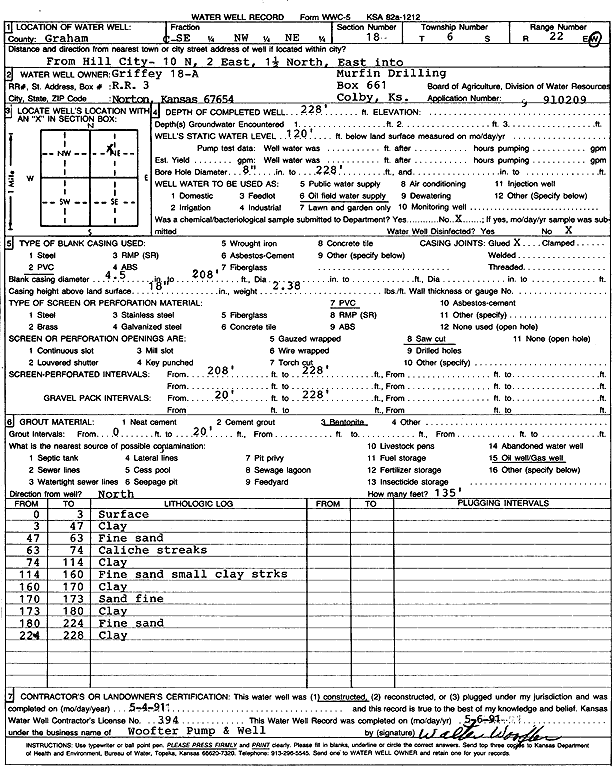
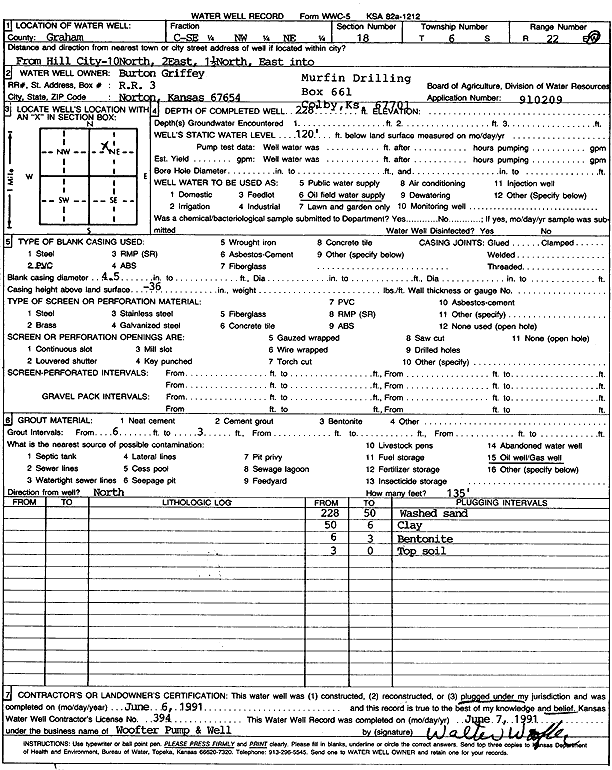
T6S, R22W, Sec. 18 SE NW NE |
Murfin Drilling Co. | 228 ft. | 120 ft. | Oil Field Water Supply | Griffey 18-A | Constructed | 04-May-1991 | Scan | |
|
T6S, R22W, Sec. 18 SE SW SW |
Murfin Drilling Co. | 180 ft. | 115 ft. | Oil Field Water Supply | Griffey 1 | Plugged | 01-Dec-1990 | Scan | |
|
T6S, R22W, Sec. 18 SE NW NE |
Murfin Drilling Co. | 228 ft. | 120 ft. | Oil Field Water Supply | Griffey 18-A | Plugged | 06-Jun-1991 | Scan | |
|
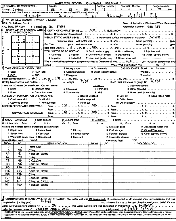
T6S, R22W, Sec. 19 NE SE NW |
Herman Jacobs | 180 ft. | 177 ft. | Oil Field Water Supply | Plugged | 21-Mar-1988 | Scan | ||
|
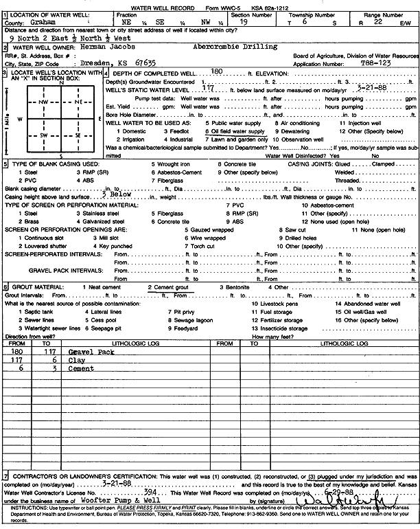
T6S, R22W, Sec. 19 NE SE NW |
Herman Jacobs | 180 ft. | 117 ft. | Oil Field Water Supply | Constructed | 01-Mar-1988 | Scan | ||
|
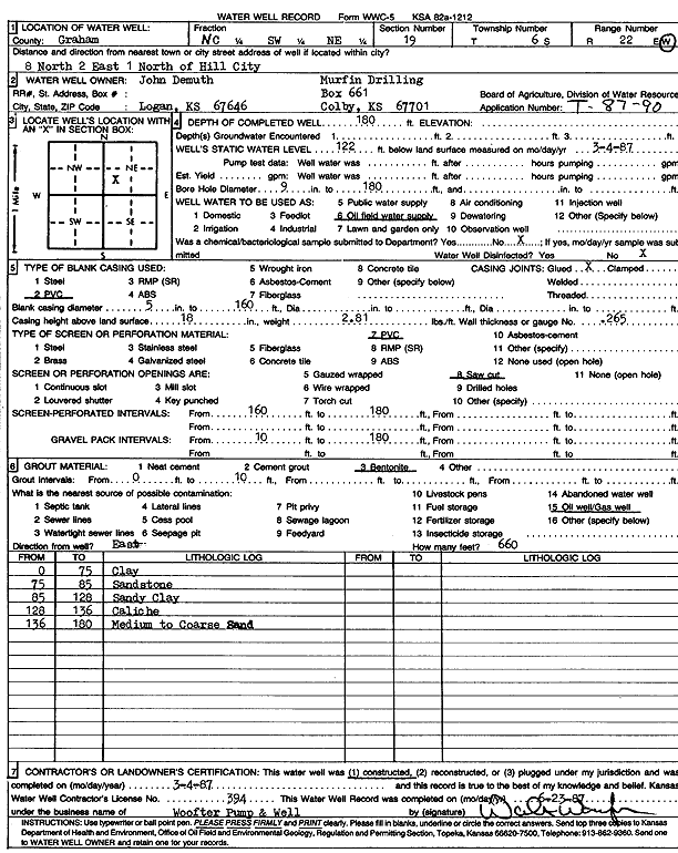
T6S, R22W, Sec. 19 C SW NE |
John Demuth/Murfin Drilling Co. | 180 ft. | 122 ft. | Oil Field Water Supply | Constructed | 04-Mar-1987 | Scan | ||
|
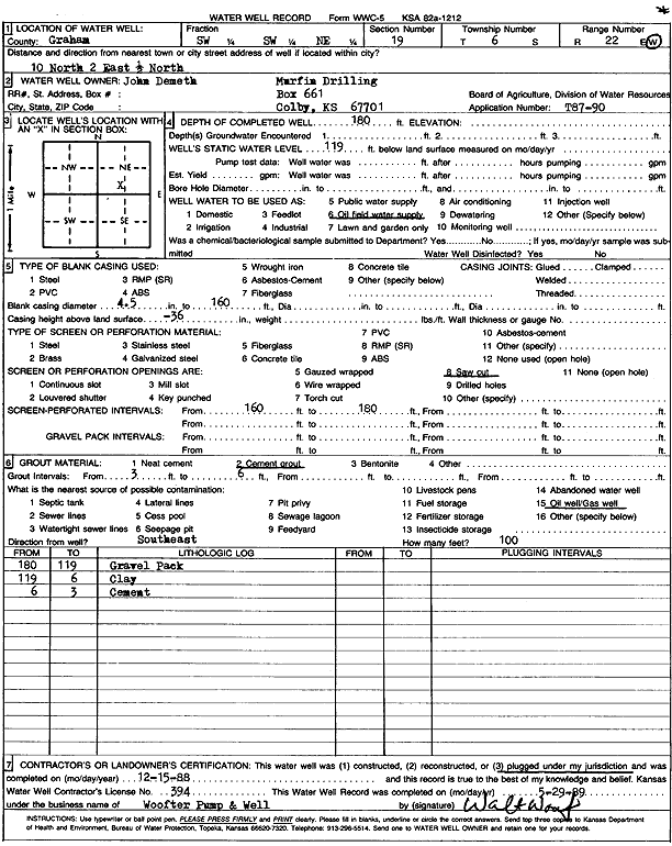
T6S, R22W, Sec. 19 SW SW NE |
Murfin Drilling Co. | 180 ft. | 119 ft. | Oil Field Water Supply | Plugged | 15-Dec-1988 | Scan | ||
|
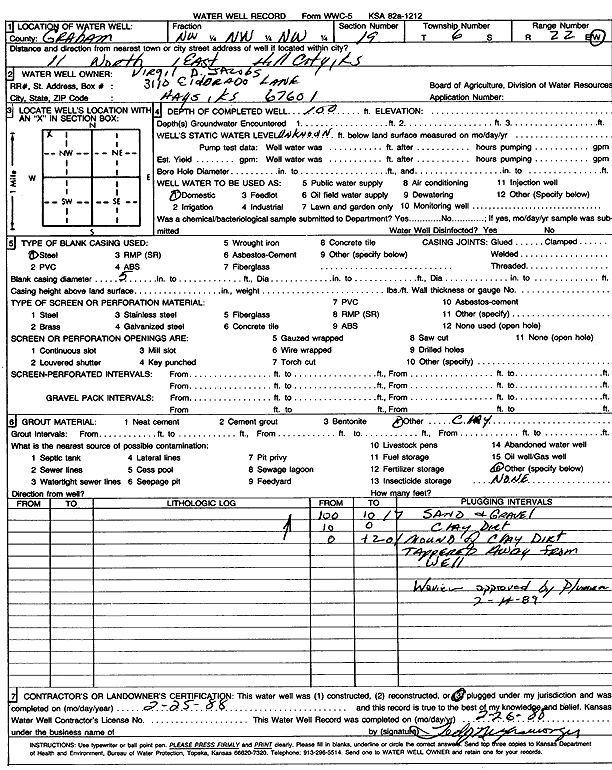
T6S, R22W, Sec. 19 NW NW NW |
Virgil Jacobs | 100 ft. | Domestic | Plugged | 25-Feb-1988 | Scan | |||
|
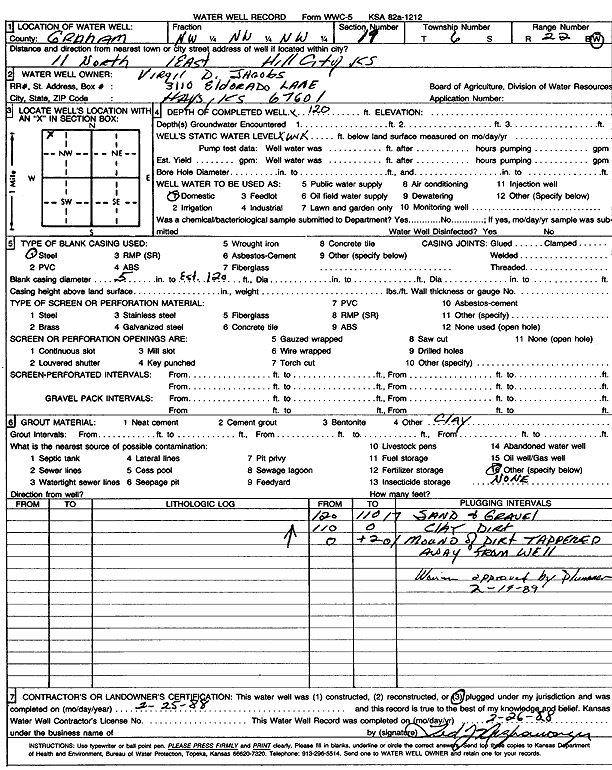
T6S, R22W, Sec. 19 NW NW NW |
Virgil Jacobs | 120 ft. | Domestic | Plugged | 25-Feb-1988 | Scan | |||
| View page: 1 || 2 || 3 || 4 || 5 || 6 || 7 || 8 || 9 || 10 || Next > | |||||||||