Select location of well to view details.
Click on column heading to sort.
|
|
|
County: Grant Select location of well to view details. Click on column heading to sort. |
|
|
|
| View page: < Prev || 21 || 22 || 23 || 24 || 25 || 26 || 27 || 28 || 29 || 30 || Next > | |||||||||
| T-R-S | Owner | Well Depth Ascend. Desc. |
Static Water Level Ascend. Desc. |
Est. Yield Ascend. Desc. |
Well Use | Other ID | Action Taken | Completion Date Ascend. Desc. |
Scan? |
|
T29S, R37W, Sec. 21 NW SW NE SE |
Mangels, Bob | 285 ft. | 270 ft. | Domestic | Plugged | 20-Jun-2014 |
KOLAR |
||
|
T29S, R37W, Sec. 21 NW SW NE SE |
Mangels, Bob | 560 ft. | 280 ft. | 30 gpm. | Domestic | Constructed | 21-May-2014 |
KOLAR |
|
|
T29S, R37W, Sec. 22 C SW SW |
Oxy USA, Inc. | 380 ft. | 200 ft. | 95 gpm. | Oil Field Water Supply | Constructed | 07-Jan-1991 | ||
|
T29S, R37W, Sec. 22 C SW SW |
Oxy USA, Inc. | 380 ft. | 200 ft. | Oil Field Water Supply | Plugged | 08-Mar-1991 | |||
|
T29S, R37W, Sec. 24 SE SE SE |
Alvarado, Jesus | 480 ft. | 297 ft. | 50 gpm. | Domestic | Constructed | 29-Aug-2023 |
KOLAR |
|
|
T29S, R37W, Sec. 24 SE SE SE NE |
Courser, Van | 513 ft. | 318 ft. | 40 gpm. | Domestic | Constructed | 20-Jul-2009 | ||
|
T29S, R37W, Sec. 24 NE NE SE |
Ferrell, Lawrence | 397 ft. | 322 ft. | Domestic | Constructed | 19-Aug-1987 | |||
|
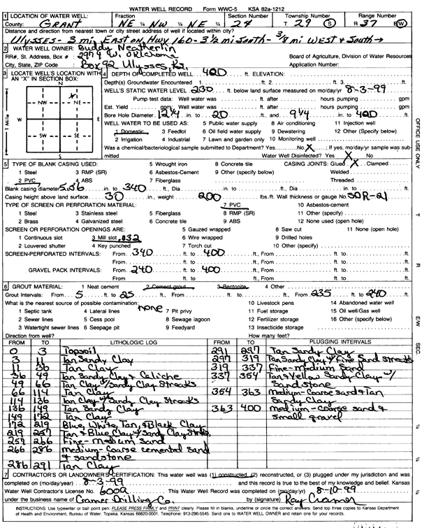
T29S, R37W, Sec. 24 NE NW NE |
Neatherlin, Buddy | 420 ft. | 230 ft. | Domestic | Constructed | 03-Aug-1999 | Scan | ||
|
T29S, R37W, Sec. 25 SW SW SE |
Meile Farms | 570 ft. | 300 ft. | Irrigation | Constructed | 05-Oct-2010 | |||
|
T29S, R37W, Sec. 26 SW SW SW |
Bell, Marjorie and Caldwell, Pat | 600 ft. | 270 ft. | Other | Plugged | 15-Mar-1996 | |||
|
T29S, R37W, Sec. 26 NW NW NW |
Montes, Hector | 503 ft. | 318 ft. | 50 gpm. | Domestic | Constructed | 11-Oct-2012 | ||
|
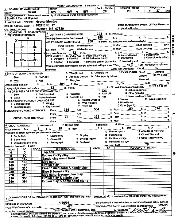
T29S, R37W, Sec. 26 NW NW NW |
Montes, Hector | 394 ft. | 180 ft. | Domestic | Constructed | 30-Apr-2001 | Scan | ||
|
T29S, R37W, Sec. 27 NE SE SW |
Graybill, Tom | 518 ft. | 222.8 ft. | 1100 gpm. | Irrigation | Constructed | 01-Nov-1976 | ||
|
T29S, R37W, Sec. 28 C SE NE |
Zenith Drilling | 360 ft. | 220 ft. | 100 gpm. | Oil Field Water Supply | 1 Calhoun | Constructed | 18-Dec-1992 | |
|
T29S, R37W, Sec. 29 NE NW NE |
Johnson, Steven | 490 ft. | 292 ft. | Irrigation | Constructed | 27-Mar-2003 | Scan | ||
|
T29S, R37W, Sec. 29 SE SW SE SE |
Parker, Don | 530 ft. | 255 ft. | 10 gpm. | Domestic | Constructed | 02-Aug-2013 |
KOLAR |
|
|
T29S, R37W, Sec. 29 SE SW SE SE |
Parker, Don | 465 ft. | 260 ft. | 15 gpm. | Domestic | Constructed | 16-Feb-2013 |
KOLAR |
|
|
T29S, R37W, Sec. 29 NE NW NW |
Smith, Kyle | 410 ft. | 235 ft. | 50 gpm. | Domestic | Constructed | 12-Jun-1978 | ||
|
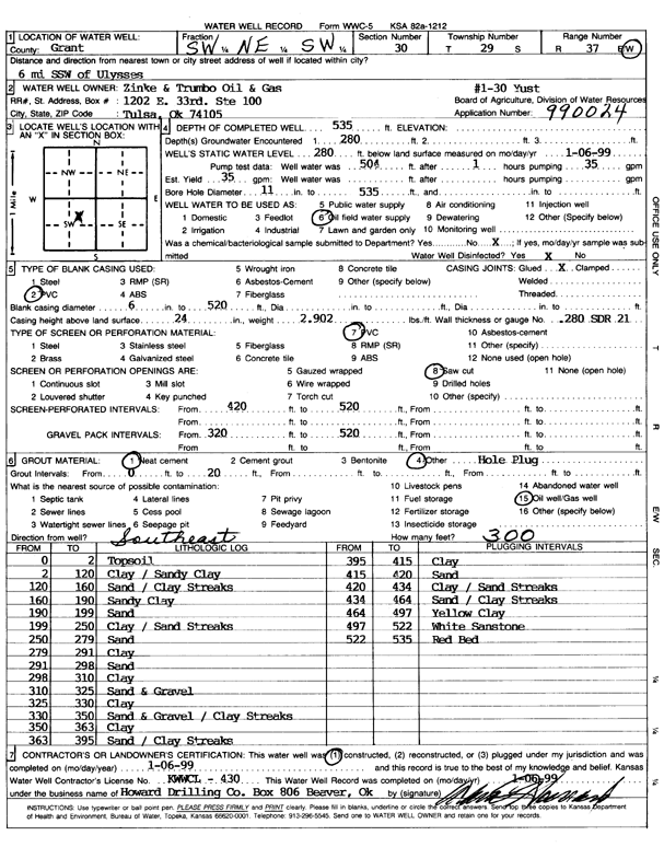
T29S, R37W, Sec. 30 SW NE SW |
Zinke and Trumbo Oil and Gas | 535 ft. | 280 ft. | 35 gpm. | Oil Field Water Supply | 1-30 Yust | Constructed | 06-Jan-1999 | Scan |
|
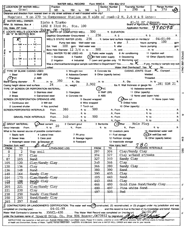
T29S, R37W, Sec. 31 NE NW NW |
Zinke and Trumbo | 500 ft. | 256 ft. | 100 gpm. | Oil Field Water Supply | 1-31 DF Johnson | Constructed | 01-Apr-1999 | Scan |
|
T29S, R37W, Sec. 32 SE SE SE |
Faulds, Robert | 360 ft. | 200 ft. | Domestic | Constructed | 12-May-1985 | |||
|
T29S, R37W, Sec. 32 SW SE SW SW |
Ford, Justin | 490 ft. | 260 ft. | 25 gpm. | Domestic | Constructed | 24-Mar-2016 |
KOLAR |
|
|
T29S, R37W, Sec. 32 NE SW SE |
Johnson, Vergil | 435 ft. | 278 ft. | 150 gpm. | Irrigation | Constructed | 21-Sep-1995 | ||
|
T29S, R37W, Sec. 32 NE SW SE |
Johnson, Vergil | 545 ft. | 321 ft. | Irrigation | Constructed | 14-Aug-1996 | |||
|
T29S, R37W, Sec. 32 NW |
Lattimore, Vernal | 405 ft. | 130 ft. | Domestic | Constructed | 03-Feb-1975 | |||
|
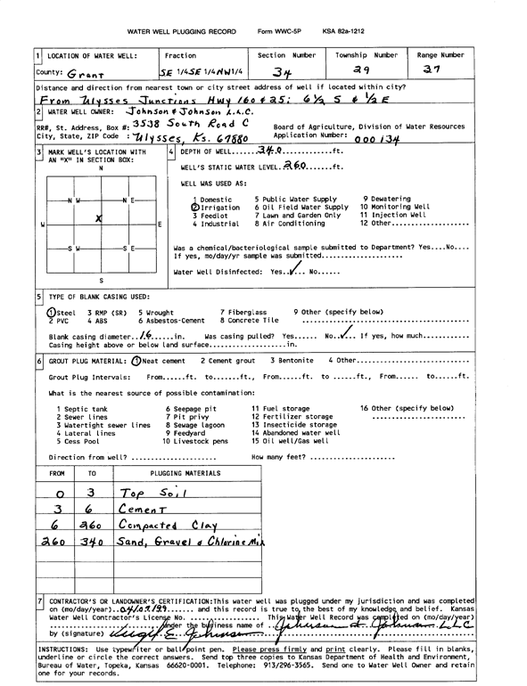
T29S, R37W, Sec. 34 SE SE NW |
Johnson and Johnson LLC | 340 ft. | 260 ft. | Irrigation | Plugged | 07-Apr-1999 | Scan | ||
|
T29S, R37W, Sec. 35 SE SW NE |
Hagerman, Rollin P. | 570 ft. | 316 ft. | Irrigation | Constructed | 22-Jun-1994 | |||
|
T29S, R37W, Sec. 35 NW SE NE |
Hagerman, Rollin R. | 530 ft. | 330 ft. | Irrigation | Plugged | 07-Mar-1998 | |||
|
T29S, R37W, Sec. 35 NW SW NE |
Jarvis, Glen | 530 ft. | 295 ft. | 800 gpm. | Irrigation | Constructed | 15-May-1975 | ||
|
T29S, R37W, Sec. 35 S2 S2 SW |
Minter-Wilson Drilling Company | 560 ft. | 380 ft. | 120 gpm. | Domestic | Constructed | 01-Apr-1996 | ||
|
T29S, R37W, Sec. 36 SW SW SW |
Wilburn, Clifton | 490 ft. | 210 ft. | Domestic | Constructed | 24-Oct-1975 | |||
|
T29S, R38W, Sec. 1 NW NW |
Olson, Mary | 475 ft. | 260 ft. | 1500 gpm. | Irrigation | Constructed | 30-Dec-1985 | ||
|
T29S, R38W, Sec. 1 SW NE SW |
Sullivan, Goldie A. | 465 ft. | 235 ft. | Irrigation | Constructed | 16-Dec-1992 | |||
|
T29S, R38W, Sec. 3 NE NE NW |
Sullivan, Daniel C. Jr. | 510 ft. | 320 ft. | Irrigation | Constructed | 23-Sep-1995 | |||
|
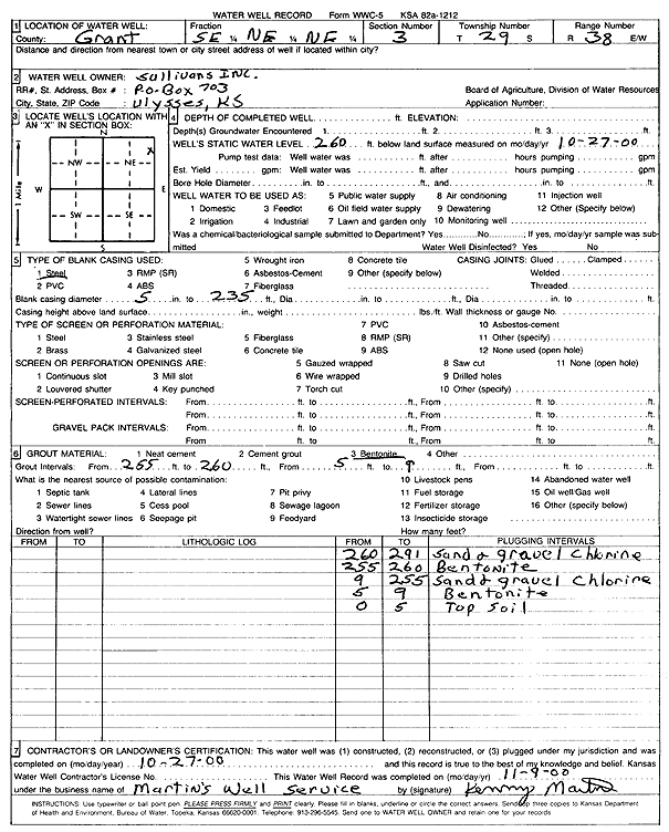
T29S, R38W, Sec. 3 SE NE NE |
Sullivans Inc. | 260 ft. | 260 ft. | (unstated)/abandoned | Plugged | 27-Oct-2000 | Scan | ||
|
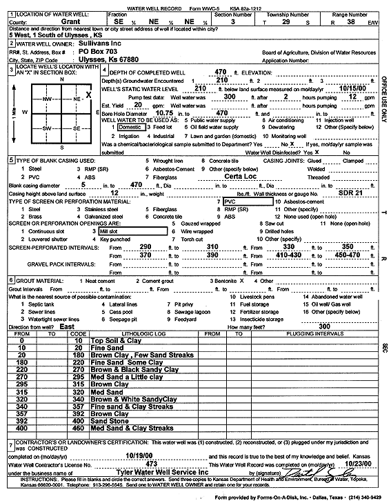
T29S, R38W, Sec. 3 SE NE NE |
Sullivans Inc. | 470 ft. | 210 ft. | 20 gpm. | Domestic | Constructed | 19-Oct-2000 | Scan | |
|
T29S, R38W, Sec. 3 SW NW NE |
Walker, Ron | 517 ft. | 267 ft. | Irrigation | Constructed | 30-Jun-1976 | |||
|
T29S, R38W, Sec. 4 SE NE NE |
Faulds, Rob | 545 ft. | 265 ft. | 1000 gpm. | Irrigation | Constructed | 31-Mar-1977 | ||
|
T29S, R38W, Sec. 5 SE NE NE |
Amoco | 95 ft. | 85 ft. | Monitoring well/observation/piezometer | Constructed | 20-Mar-1997 | Scan | ||
|
T29S, R38W, Sec. 5 NE NE NE |
BP America Production Co | 445 ft. | 230 ft. | Industrial | Plugged | 13-May-2009 | |||
|
T29S, R38W, Sec. 5 SW NE NE |
BP America Production Co | 453 ft. | 225 ft. | Industrial | Plugged | 13-May-2009 | |||
|
T29S, R38W, Sec. 5 SW SW SW NE |
BP America Production Co. | 358 ft. | Monitoring well/observation/piezometer | Plugged | 27-Dec-2012 | ||||
|
T29S, R38W, Sec. 5 SW NE NE NE |
BP America Production Co. | 95 ft. | Monitoring well/observation/piezometer | Plugged | 27-Dec-2012 | ||||
|
T29S, R38W, Sec. 5 NW NW NW NE |
BP America Production Co. | 304 ft. | Monitoring well/observation/piezometer | Plugged | 27-Dec-2012 | ||||
|
T29S, R38W, Sec. 5 SE SW SW |
Koop, Ira | 545 ft. | Irrigation | Constructed | 31-Oct-1979 | ||||
|
T29S, R38W, Sec. 5 NW NW NE NE |
Stantec Consulting | 495 ft. | 260 ft. | 100 gpm. | Irrigation | Constructed | 08-Nov-2012 |
KOLAR |
|
|
T29S, R38W, Sec. 5 NW NW NE NE |
Stantec Consulting | 495 ft. | 260 ft. | 100 gpm. | Irrigation | Constructed | 08-Nov-2012 | ||
|
T29S, R38W, Sec. 7 NW NW NW SE |
Cheatman, Tony and LaDonna | 602 ft. | 374 ft. | 1003 gpm. | Irrigation | Constructed | 23-Jun-2021 |
KOLAR |
|
|
T29S, R38W, Sec. 7 NW SW SW |
Johnson, Vergil | 550 ft. | 220 ft. | Irrigation | Constructed | 18-Nov-1993 | |||
|
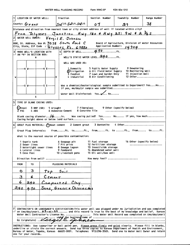
T29S, R38W, Sec. 7 SW SW SW |
Johnson, Vergil E. | 470 ft. | 240 ft. | Irrigation | Plugged | 01-Mar-1999 | Scan | ||
| View page: < Prev || 21 || 22 || 23 || 24 || 25 || 26 || 27 || 28 || 29 || 30 || Next > | |||||||||