Select location of well to view details.
Click on column heading to sort.
|
|
|
County: Grant Select location of well to view details. Click on column heading to sort. |
|
|
|
| View page: < Prev || 21 || 22 || 23 || 24 || 25 || 26 || 27 || 28 || 29 || 30 || Next > | |||||||||
| T-R-S | Owner | Well Depth Ascend. Desc. |
Static Water Level Ascend. Desc. |
Est. Yield Ascend. Desc. |
Well Use | Other ID | Action Taken | Completion Date Ascend. Desc. |
Scan? |
|
T30S, R35W, Sec. 28 C SE |
Christian, Willis | 375 ft. | 136 ft. | Irrigation | Constructed | 24-Feb-1975 | |||
|
T30S, R35W, Sec. 28 NW SE NW SE |
Linn Operating Inc. | 200 ft. | 199 ft. | Oil Field Water Supply | Plugged | 23-May-2018 |
KOLAR |
||
|
T30S, R35W, Sec. 28 NE NW |
Sage Drilling | 240 ft. | 125 ft. | 45 gpm. | Oil Field Water Supply | Hooper 2-28 | Constructed | 03-May-1975 | |
|
T30S, R35W, Sec. 28 NW NE |
Zenith Drilling Co. | 204 ft. | 120 ft. | 50 gpm. | Oil Field Water Supply | Hooper 1-28 | Constructed | 05-Apr-1975 | |
|
T30S, R35W, Sec. 30 SW NW NW |
Lahey, Tom | 297 ft. | 160 ft. | 15 gpm. | Domestic | Constructed | 03-Nov-1984 | ||
|
T30S, R35W, Sec. 31 SE SW NE SE |
Randles, Wesley | 540 ft. | 270 ft. | 40 gpm. | Domestic | Constructed | 03-Jan-2014 |
KOLAR |
|
|
T30S, R35W, Sec. 32 NE SE NW |
Lewis, Victor | 462 ft. | 184 ft. | 700 gpm. | Irrigation | Constructed | 30-Sep-1976 | ||
|
T30S, R35W, Sec. 33 C NE NE |
Sweetman Drilling Co | 460 ft. | 185 ft. | 100 gpm. | Oil Field Water Supply | Constructed | 06-Mar-1990 | ||
|
T30S, R35W, Sec. 33 C SW SE |
Sweetman Drilling Inc | 360 ft. | 115 ft. | 110 gpm. | Oil Field Water Supply | Constructed | 24-Jan-1991 | ||
|
T30S, R35W, Sec. 34 SE NW SE |
Christenson, Willis/ Mobil Oil Corp. | 300 ft. | 120 ft. | 100 gpm. | Oil Field Water Supply | Mary Lahey 3 | Constructed | 03-Apr-1986 | |
|
T30S, R35W, Sec. 34 C SE SE |
Christian, Willis | 364 ft. | 133 ft. | Irrigation | Constructed | 26-Feb-1975 | |||
|
T30S, R35W, Sec. 34 SW SW SE |
Grant County Bank/ Mobil Oil Corp. | 275 ft. | 132 ft. | 75 gpm. | Oil Field Water Supply | Mary Lahey 1 | Constructed | 11-Jan-1985 | |
|
T30S, R35W, Sec. 34 SE NE SW |
Grant County State Bank/ Mobil Oil Corp. | 300 ft. | 121 ft. | 100 gpm. | Oil Field Water Supply | Mary Lahey 2 | Constructed | 06-Jan-1986 | |
|
T30S, R35W, Sec. 34 SW SE SW |
Grant County State Bank/ Mobil Oil Corp. | 305 ft. | 120 ft. | 100 gpm. | Oil Field Water Supply | Mary Lahey 4 | Constructed | 17-Mar-1986 | |
|
T30S, R35W, Sec. 34 SE SE SE |
Lahey, Tom | 515 ft. | 202 ft. | Irrigation | Constructed | 30-Apr-2010 | |||
|
T30S, R35W, Sec. 35 SW SW NE |
Simmons Energy Corp. | 285 ft. | 182 ft. | 65 gpm. | Oil Field Water Supply | Avalon D-M 35-7 | Constructed | 04-Mar-1988 | |
|
T30S, R35W, Sec. 36 SE SE SW |
SW Windmill/Foster, Robert | 420 ft. | 240 ft. | Domestic | Constructed | 12-Apr-2010 | |||
|
T30S, R35W, Sec. 36 SE SE NW |
Taff, John H. | 220 ft. | 175 ft. | 20 gpm. | Domestic | Reconstructed | 16-Dec-1985 | ||
|
T30S, R36W, Sec. 1 SW NE NE |
Pioneer Natural Resources | 300 ft. | 202 ft. | 27 gpm. | Oil Field Water Supply | Hall 3-1 | Constructed | 02-Oct-1997 | |
|
T30S, R36W, Sec. 1 NW SE SE SW |
Zulauf, Zach | 540 ft. | 320 ft. | 30 gpm. | Domestic, Livestock | Constructed | 19-Aug-2019 | ||
|
T30S, R36W, Sec. 1 NW SE SE SW |
Zulauf, Zack | 540 ft. | 320 ft. | 30 gpm. | Domestic, Livestock | Constructed | 19-Aug-2019 | ||
|
T30S, R36W, Sec. 4 SE |
Alford, Pauline | 570 ft. | Irrigation | Constructed | 30-Nov-1979 | ||||
|
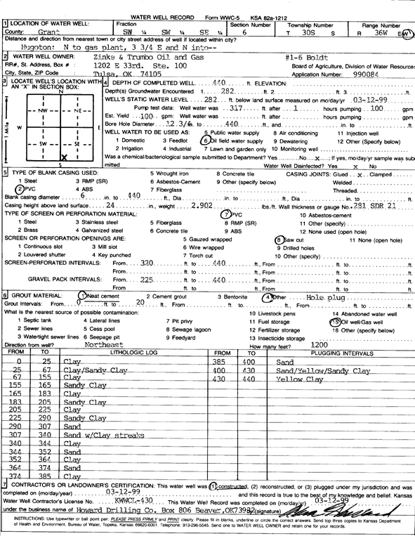
T30S, R36W, Sec. 6 SW SW SE |
Zinke and Trumbo Oil and Gas | 440 ft. | 282 ft. | 100 gpm. | Oil Field Water Supply | Boldt 1-6 | Constructed | 12-Mar-1999 | Scan |
|
T30S, R36W, Sec. 7 NW NW SW |
Curtis, Phyllis | 505 ft. | 235 ft. | 900 gpm. | Irrigation | Constructed | 30-Sep-1978 | ||
|
T30S, R36W, Sec. 7 NW NE NW |
Schaffer, Robert | 355 ft. | 255 ft. | Irrigation | Plugged | 27-Apr-1995 | |||
|
T30S, R36W, Sec. 7 NW NE NE |
Shafer, Robert J. | 580 ft. | 270 ft. | Irrigation | Constructed | 21-Feb-1995 | |||
|
T30S, R36W, Sec. 8 NW |
Alford, Pauline | 545 ft. | Irrigation | Constructed | 31-Dec-1979 | ||||
|
T30S, R36W, Sec. 8 SW SW SE |
McBride Investments LLC | 599 ft. | 292 ft. | Irrigation | Constructed | 17-Jan-2025 |
KOLAR |
||
|
T30S, R36W, Sec. 9 NW SW NW |
Alford, Stephen J. | 480 ft. | 247 ft. | Irrigation | Constructed | 06-Apr-1991 | |||
|
T30S, R36W, Sec. 9 SW NW SE |
Jennings, Wilma | 504 ft. | 194 ft. | 850 gpm. | Irrigation | Constructed | 02-Nov-1980 | ||
|
T30S, R36W, Sec. 9 SW |
McBride, Bob | 400 ft. | 210 ft. | Irrigation | Constructed | 09-Mar-1981 | |||
|
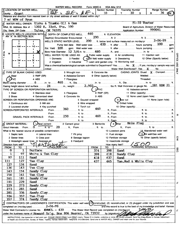
T30S, R36W, Sec. 10 SE SE NE |
Zinke and Trumbo Oil and Gas | 460 ft. | 200 ft. | Oil Field Water Supply | Teeter 1-10 | Constructed | 04-Feb-1999 | Scan | |
|
T30S, R36W, Sec. 12 SE SE NE |
Davidson, Lyle Sr. | 381 ft. | 180 ft. | 800 gpm. | Irrigation | Constructed | 31-May-1980 | ||
|
T30S, R36W, Sec. 15 SE SE SW |
Teeter, Earl | 420 ft. | 227 ft. | Domestic | Constructed | 06-Apr-1998 | |||
|
T30S, R36W, Sec. 16 NE NW SE |
Kantex Feeders | 525 ft. | 225 ft. | Feedlot | Constructed | 02-Oct-1993 | |||
|
T30S, R36W, Sec. 16 NE SE SE |
Kantex Feeders | 320 ft. | 160 ft. | Feedlot | Constructed | 24-Aug-1984 | |||
|
T30S, R36W, Sec. 16 NW NE SE |
Ulysses Feedyard | 390 ft. | 260 ft. | Irrigation | Plugged | 25-Feb-2005 | |||
|
T30S, R36W, Sec. 17 NE NE SE SE |
Cactus of Kansas | 460 ft. | 334 ft. | 239 gpm. | Irrigation | Constructed | 28-Aug-2012 |
KOLAR |
|
|
T30S, R36W, Sec. 17 NE NE SE |
Minter WIllson Drilling Co | 420 ft. | 160 ft. | 150 gpm. | Feedlot | Kan-Tex 2 | Constructed | 17-May-1996 | |
|
T30S, R36W, Sec. 18 NW NE NE |
Christensen, Wayne | 485 ft. | 264 ft. | 50 gpm. | Domestic | Constructed | 12-Feb-1985 | ||
|
T30S, R36W, Sec. 19 NE NE NW |
Keith Schwein Estate | 450 ft. | 280 ft. | Domestic | Constructed | 22-Sep-1975 | |||
|
T30S, R36W, Sec. 20 NW |
Prime Beef Feeders | 292 ft. | 150 ft. | Domestic | Constructed | 22-Jun-1981 | |||
|
T30S, R36W, Sec. 20 NW NW NW |
Thurow, Carl | 310 ft. | 145 ft. | Domestic, Livestock | Constructed | 23-Jul-1980 | |||
|
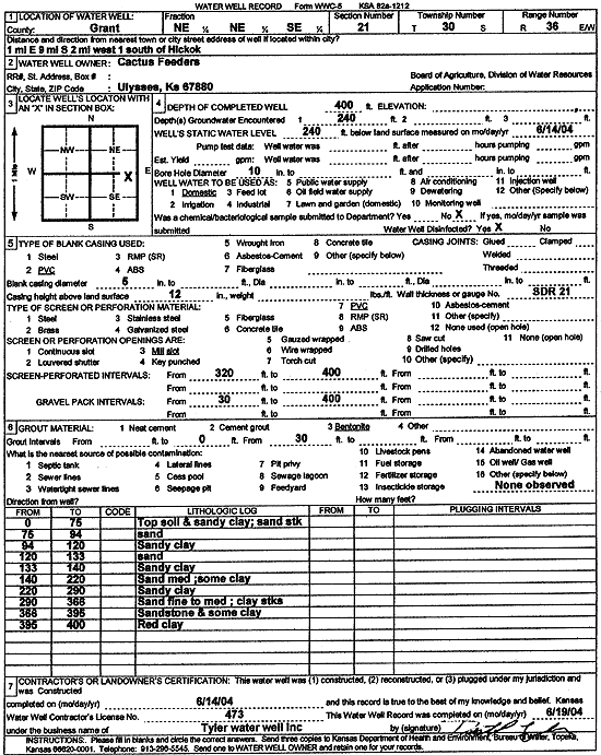
T30S, R36W, Sec. 21 NE NE SE |
Cactus Feeders | 400 ft. | 240 ft. | Domestic | Constructed | 14-Jun-2004 | Scan | ||
|
T30S, R36W, Sec. 22 NE NW NW |
Minter-Wilson | 420 ft. | 200 ft. | 85 gpm. | Feedlot | Kan Tex Feed Lot | Constructed | 24-Feb-1996 | |
|
T30S, R36W, Sec. 22 SW NE NE |
Powers, Don | 340 ft. | 180 ft. | Domestic | Constructed | 02-Aug-1980 | |||
|
T30S, R36W, Sec. 23 NW SW NW |
Demuth, Tex | 260 ft. | 145 ft. | Domestic | Constructed | 15-Sep-1977 | |||
|
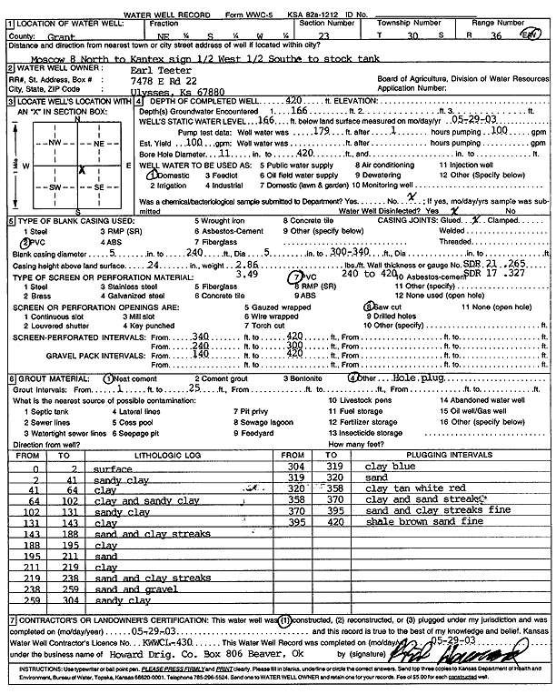
T30S, R36W, Sec. 23 NE SW |
Teeter, Earl | 420 ft. | 166 ft. | 100 gpm. | Domestic | Constructed | 29-May-2003 | Scan | |
|
T30S, R36W, Sec. 23 SE SE NW |
Teeter, Melvin | 300 ft. | 160 ft. | Domestic | Constructed | 22-Sep-1988 | |||
|
T30S, R36W, Sec. 24 S2 SE |
Brewer, Gary | 321 ft. | 162 ft. | Domestic | Constructed | 07-Oct-1985 | |||
| View page: < Prev || 21 || 22 || 23 || 24 || 25 || 26 || 27 || 28 || 29 || 30 || Next > | |||||||||