Select location of well to view details.
Click on column heading to sort.
|
|
|
County: Grant Select location of well to view details. Click on column heading to sort. |
|
|
|
| View page: < Prev || 21 || 22 || 23 || 24 || 25 || 26 || 27 || 28 || 29 || 30 || Next > | |||||||||
| T-R-S | Owner | Well Depth Ascend. Desc. |
Static Water Level Ascend. Desc. |
Est. Yield Ascend. Desc. |
Well Use | Other ID | Action Taken | Completion Date Ascend. Desc. |
Scan? |
|
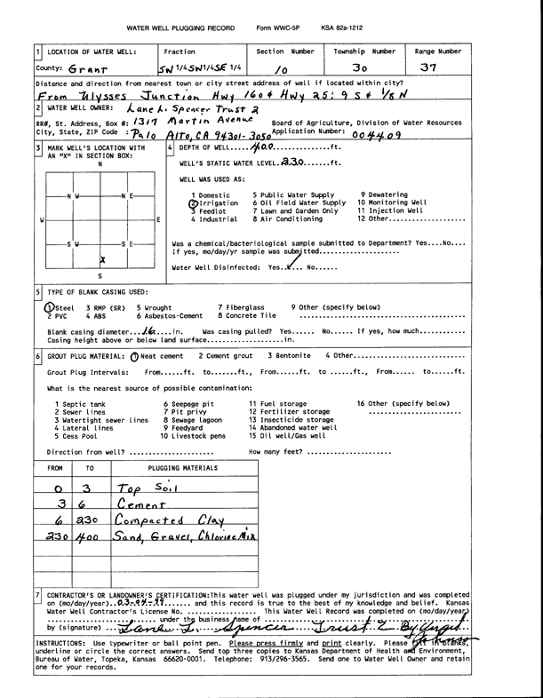
T30S, R37W, Sec. 10 SW SW SE |
Lane L. Spencer Trust 2 | 400 ft. | 230 ft. | Irrigation | Plugged | 04-Mar-1999 | Scan | ||
|
T30S, R37W, Sec. 10 NW NW |
Pioneer Natural Resources USA | 110 ft. | Recovery/Soil Vapor Extraction/Soil Vent | SVE 4 | Constructed | 15-Feb-2012 | |||
|
T30S, R37W, Sec. 10 NW NW |
Pioneer Natural Resources USA | 270 ft. | Monitoring well/observation/piezometer | MW 1 | Constructed | 15-Feb-2012 | |||
|
T30S, R37W, Sec. 10 NW NW |
Pioneer Natural Resources USA | 110 ft. | Recovery/Soil Vapor Extraction/Soil Vent | SVE 5 | Constructed | 13-Feb-2012 | |||
|
T30S, R37W, Sec. 10 NW NW |
Pioneer Natural Resources USA | 110 ft. | Recovery/Soil Vapor Extraction/Soil Vent | SVE 6 | Constructed | 14-Feb-2012 | |||
|
T30S, R37W, Sec. 10 NW NW |
Pioneer Natural Resources USA | 110 ft. | Recovery/Soil Vapor Extraction/Soil Vent | SVE 3 | Constructed | 14-Feb-2012 | |||
|
T30S, R37W, Sec. 10 NW NW |
Pioneer Natural Resources USA | 110 ft. | Recovery/Soil Vapor Extraction/Soil Vent | SVE 2 | Constructed | 15-Feb-2012 | |||
|
T30S, R37W, Sec. 10 NW NW |
Pioneer Natural Resources USA | 110 ft. | Recovery/Soil Vapor Extraction/Soil Vent | SVE 1 | Constructed | 13-Feb-2012 | |||
|
T30S, R37W, Sec. 10 NW NW |
Pioneer Natural Resources, USA | 121.5 ft. | Environmental Remediation, Soil Vapor Extraction | SVE 7 | Constructed | 20-Aug-2014 | |||
|
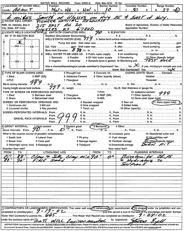
T30S, R37W, Sec. 10 NW NE NW |
Pioneer Resources | 90 ft. | Test hole/well | Plugged | 19-Sep-2002 | Scan | |||
|
T30S, R37W, Sec. 10 NW NW NW |
Pioneer Resources | 340 ft. | 280 ft. | Industrial | Plugged | 22-Feb-2005 | |||
|
T30S, R37W, Sec. 10 SE NW NW |
Pioneer Resources | 350 ft. | 280 ft. | Industrial | Plugged | 22-Feb-2005 | |||
|
T30S, R37W, Sec. 10 NE NW NW |
Scout | 66 ft. | Monitoring well/observation/piezometer | BV 2D | Plugged | 15-Oct-2025 |
KOLAR |
||
|
T30S, R37W, Sec. 10 NE NW NW |
Scout | 66 ft. | Monitoring well/observation/piezometer | BV 5D | Plugged | 15-Oct-2025 |
KOLAR |
||
|
T30S, R37W, Sec. 10 NE NW NW |
Scout | 111 ft. | Monitoring well/observation/piezometer | BV 5D | Plugged | 15-Oct-2025 |
KOLAR |
||
|
T30S, R37W, Sec. 10 NE NW NW |
Scout | 66 ft. | Monitoring well/observation/piezometer | BV 3D | Plugged | 15-Oct-2025 |
KOLAR |
||
|
T30S, R37W, Sec. 10 NE NW NW |
Scout | 123 ft. | Monitoring well/observation/piezometer | BV 4S | Plugged | 15-Oct-2025 |
KOLAR |
||
|
T30S, R37W, Sec. 10 NE NW NW |
Scout | 65 ft. | Monitoring well/observation/piezometer | BV 3S | Plugged | 15-Oct-2025 |
KOLAR |
||
|
T30S, R37W, Sec. 10 NE NW NW |
Scout | 68 ft. | Monitoring well/observation/piezometer | BV 4S | Plugged | 15-Oct-2025 |
KOLAR |
||
|
T30S, R37W, Sec. 10 NE NW NW |
Scout | 67 ft. | Monitoring well/observation/piezometer | BV 4D | Plugged | 15-Oct-2025 |
KOLAR |
||
|
T30S, R37W, Sec. 10 NE NW NW |
Scout | 111 ft. | Monitoring well/observation/piezometer | BV 5S | Plugged | 15-Oct-2025 |
KOLAR |
||
|
T30S, R37W, Sec. 10 NE NW NW |
Scout | 111 ft. | Monitoring well/observation/piezometer | BV 3S | Plugged | 15-Oct-2025 |
KOLAR |
||
|
T30S, R37W, Sec. 10 NE NW NW |
Scout | 144 ft. | Monitoring well/observation/piezometer | BV 2S | Plugged | 15-Oct-2025 |
KOLAR |
||
|
T30S, R37W, Sec. 10 NE NW NW |
Scout | 111 ft. | Monitoring well/observation/piezometer | BV 2D | Plugged | 15-Oct-2025 |
KOLAR |
||
|
T30S, R37W, Sec. 10 NE NW NW |
Scout | 63 ft. | Monitoring well/observation/piezometer | MW 1 | Plugged | 15-Oct-2025 |
KOLAR |
||
|
T30S, R37W, Sec. 10 NE NW NW |
Scout | 111 ft. | Monitoring well/observation/piezometer | BV 4D | Plugged | 15-Oct-2025 |
KOLAR |
||
|
T30S, R37W, Sec. 10 NE NW NW |
Scout | 66 ft. | Monitoring well/observation/piezometer | BV 5S | Plugged | 15-Oct-2025 |
KOLAR |
||
|
T30S, R37W, Sec. 10 NE NW NW |
Scout | 111 ft. | Monitoring well/observation/piezometer | BV 3D | Plugged | 15-Oct-2025 |
KOLAR |
||
|
T30S, R37W, Sec. 10 SW SW SE |
Spencer, Henrietta | 524 ft. | 201 ft. | 1000 gpm. | Irrigation | Constructed | 15-Jul-1975 | ||
|
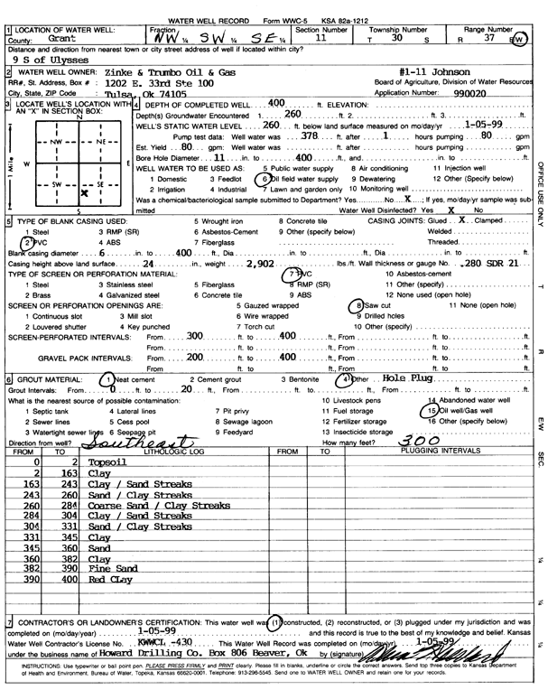
T30S, R37W, Sec. 11 NW SW SE |
Zinke and Trumbo Oil and Gas | 400 ft. | 260 ft. | 80 gpm. | Oil Field Water Supply | Johnson 1-11 | Constructed | 05-Jan-1999 | Scan |
|
T30S, R37W, Sec. 12 SE SW |
Curtis, George | 80 ft. | Domestic | Plugged | 20-Jan-1997 | ||||
|
T30S, R37W, Sec. 12 SE SW SE NW |
Feedyards Inc./Ulysses Feedyard | 552 ft. | 272 ft. | 250 gpm. | Irrigation | Constructed | 26-Jan-2022 |
KOLAR |
|
|
T30S, R37W, Sec. 14 NE NE SE |
Premier Feeders/ Butler Environmental | 265 ft. | 205 ft. | Monitoring well/observation/piezometer | Constructed | 18-Feb-1993 | |||
|
T30S, R37W, Sec. 14 NW NW NE |
Stout, Dave | 280 ft. | Irrigation | Constructed | 30-Sep-1978 | ||||
|
T30S, R37W, Sec. 14 NW NE NE |
Ulysses Feedyard | 431 ft. | 249 ft. | Irrigation | Constructed | 22-Dec-2010 | |||
|
T30S, R37W, Sec. 14 NE |
Ulysses Feedyard | 260 ft. | 245 ft. | Feedlot | Plugged | 09-Oct-2012 | |||
|
T30S, R37W, Sec. 14 NE |
Ulysses Feedyard | 286 ft. | 262 ft. | Feedlot | Plugged | 27-Jan-2011 | |||
|
T30S, R37W, Sec. 14 NE |
Ulysses Feedyard | 260 ft. | 245 ft. | Feedlot | Plugged | 09-Oct-2012 | |||
|
T30S, R37W, Sec. 15 SE SW SE |
Oxy USA, Inc. | 340 ft. | 210 ft. | 100 gpm. | Oil Field Water Supply | MLP Doles A 1 | Constructed | 20-Sep-1993 | |
|
T30S, R37W, Sec. 15 SE SW SE |
Oxy USA, Inc. | 340 ft. | 210 ft. | Oil Field Water Supply | MLP Doles A 1 | Plugged | 10-Mar-1994 | ||
|
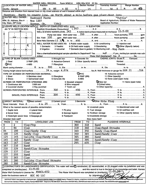
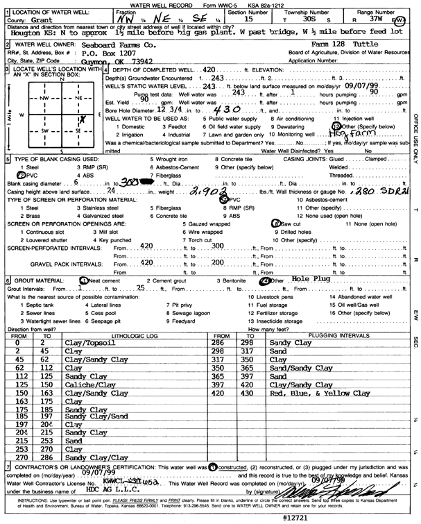
T30S, R37W, Sec. 15 NW NE SE |
Seaboard Farms Co. | 400 ft. | 243 ft. | Feedlot | Tuttle | Constructed | 09-Nov-2000 | Scan | |
|
T30S, R37W, Sec. 15 NW NE SE |
Seaboard Farms Co. | 420 ft. | 243 ft. | Domestic | Constructed | 07-Sep-1999 | Scan | ||
|
T30S, R37W, Sec. 15 NW NW SW |
Staats, Pat | 550 ft. | 247 ft. | Irrigation | Constructed | 23-Jan-1997 | |||
|
T30S, R37W, Sec. 15 C NE NW |
Zinke and Trumbo Oil and Gas | 380 ft. | 240 ft. | 100 gpm. | Oil Field Water Supply | Smith PW 1-15 | Constructed | 02-Jan-1997 | |
|
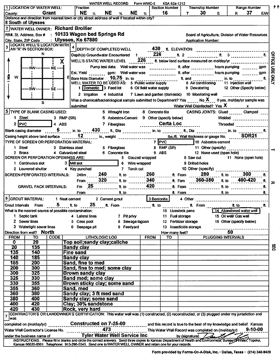
T30S, R37W, Sec. 16 NE NE NE |
Brollier, Richard | 430 ft. | 226 ft. | Domestic | Constructed | 25-Jul-2000 | Scan | ||
|
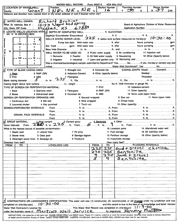
T30S, R37W, Sec. 16 NE NE NE |
Brollier, Richard | 225 ft. | (unstated)/abandoned | Constructed | 30-Oct-2000 | Scan | |||
|
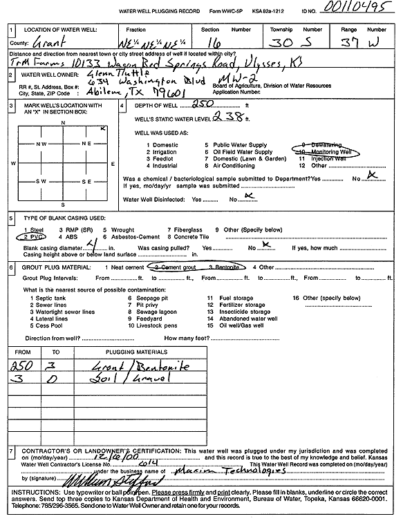
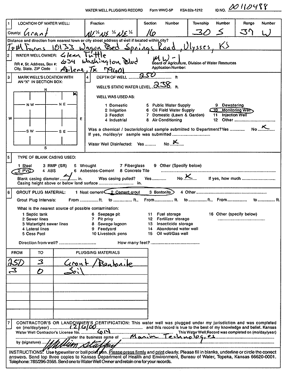
T30S, R37W, Sec. 16 NE NE NE |
Tuttle, Glenn | 250 ft. | 238 ft. | Monitoring well/observation/piezometer | Plugged | 06-Dec-2000 | Scan | ||
|
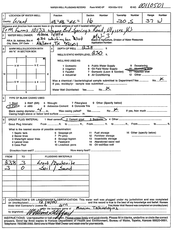
T30S, R37W, Sec. 16 NE NE NE |
Tuttle, Glenn | 238 ft. | 230 ft. | Monitoring well/observation/piezometer | MW 3 | Plugged | 06-Dec-2000 | Scan | |
|
T30S, R37W, Sec. 16 NE NE NE |
Tuttle, Glenn | 250 ft. | 238 ft. | Monitoring well/observation/piezometer | Plugged | 06-Dec-2000 | Scan | ||
|
T30S, R37W, Sec. 16 SW NE NE |
Tuttle, Glenn/ T and M Farms | 238 ft. | 227.5 ft. | Monitoring well/observation/piezometer | MW 3 | Constructed | 16-Jan-1995 | ||
| View page: < Prev || 21 || 22 || 23 || 24 || 25 || 26 || 27 || 28 || 29 || 30 || Next > | |||||||||