Select location of well to view details.
Click on column heading to sort.
|
|
|
County: Haskell Select location of well to view details. Click on column heading to sort. |
|
|
|
| View page: < Prev || 11 || 12 || 13 || 14 || 15 || 16 || 17 || 18 || 19 || 20 || Next > | |||||||||
| T-R-S | Owner | Well Depth Ascend. Desc. |
Static Water Level Ascend. Desc. |
Est. Yield Ascend. Desc. |
Well Use | Other ID | Action Taken | Completion Date Ascend. Desc. |
Scan? |
|
T27S, R34W, Sec. 12 S2 S2 SW |
Helmerich and Payne Inc. | 320 ft. | 200 ft. | 100 gpm. | Oil Field Water Supply | Government B 2 | Constructed | 04-Mar-2000 | |
|
T27S, R34W, Sec. 13 SW NW NE |
Frey, John | 347 ft. | 148 ft. | 1325 gpm. | Irrigation | Constructed | 21-Apr-1975 | ||
|
T27S, R34W, Sec. 13 NW NE SW |
Frey, John | 345 ft. | 164 ft. | 1404 gpm. | Irrigation | Constructed | 21-Apr-1975 | ||
|
T27S, R34W, Sec. 13 NW NE NE SW |
McBride Three Partnership | 624 ft. | 337 ft. | 1003 gpm. | Irrigation | Constructed | 22-Mar-2016 |
KOLAR |
|
|
T27S, R34W, Sec. 13 SW NW NW NE |
McBride, Evelyn L. | 523 ft. | 305 ft. | 808 gpm. | Irrigation | Constructed | 16-May-2014 |
KOLAR |
|
|
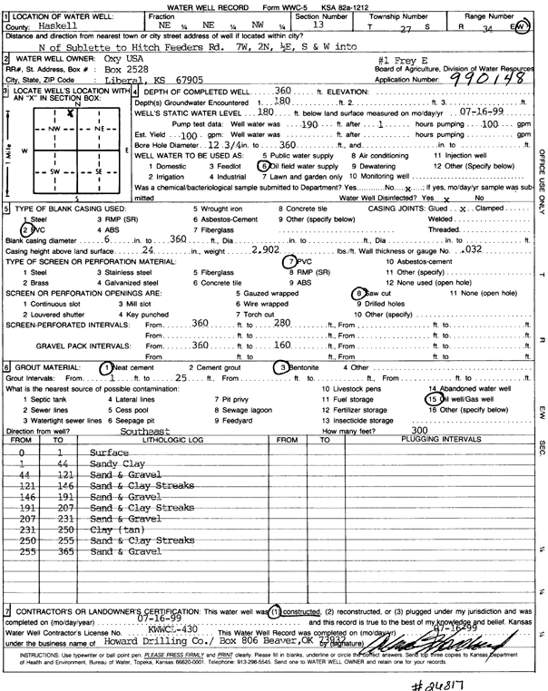
T27S, R34W, Sec. 13 NE NE NW |
Oxy USA, Inc. | 360 ft. | 180 ft. | 100 gpm. | Oil Field Water Supply | Frey E 1 | Constructed | 16-Jul-1999 | Scan |
|
T27S, R34W, Sec. 14 C SW NW |
Cities Service | 300 ft. | 137 ft. | 60 gpm. | Oil Field Water Supply | Engler C 1 | Constructed | 17-May-1982 | |
|
T27S, R34W, Sec. 14 SW NE NE |
Oliver, Manley | 336 ft. | 142 ft. | 3500 gpm. | Irrigation | Constructed | 30-Jul-1976 | ||
|
T27S, R34W, Sec. 14 SE NW SW |
Oliver, Mildred | 308 ft. | 163 ft. | 2000 gpm. | Irrigation | Constructed | 26-Jun-1979 | ||
|
T27S, R34W, Sec. 14 NE SW NE |
Stricklin, Dorothy | 500 ft. | 320 ft. | 50 gpm. | Domestic, Livestock | Constructed | 17-Jun-2025 |
KOLAR |
|
|
T27S, R34W, Sec. 14 NE SW NE |
Stricklin, Dorothy | 498 ft. | 330 ft. | 50 gpm. | Domestic, Livestock | Constructed | 21-Jul-2025 |
KOLAR |
|
|
T27S, R34W, Sec. 15 SW SW NE SE |
Apsley, Casey | 445 ft. | 298 ft. | Domestic, Livestock | Constructed | 12-Mar-2020 | |||
|
T27S, R34W, Sec. 15 NW SW NE |
Cheyenne Drilling, LP | 360 ft. | 225 ft. | 90 gpm. | Oil Field Water Supply | KC Feedlot 5 | Constructed | 20-May-2006 | |
|
T27S, R34W, Sec. 15 NW NW SW |
Cimarex Energy | 196 ft. | Domestic | Plugged | 29-Mar-2005 | ||||
|
T27S, R34W, Sec. 15 NW SW SW |
Engler, Bill | 335 ft. | 180 ft. | Domestic | Constructed | 02-Oct-1980 | |||
|
T27S, R34W, Sec. 15 NW NW SW |
Helmerich and Payne Inc. | 360 ft. | 187 ft. | 25 gpm. | Domestic | Constructed | 28-Jun-1988 | ||
|
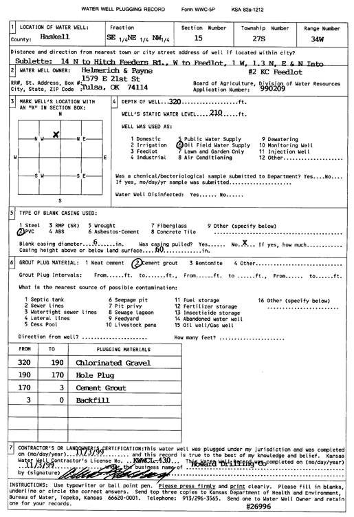
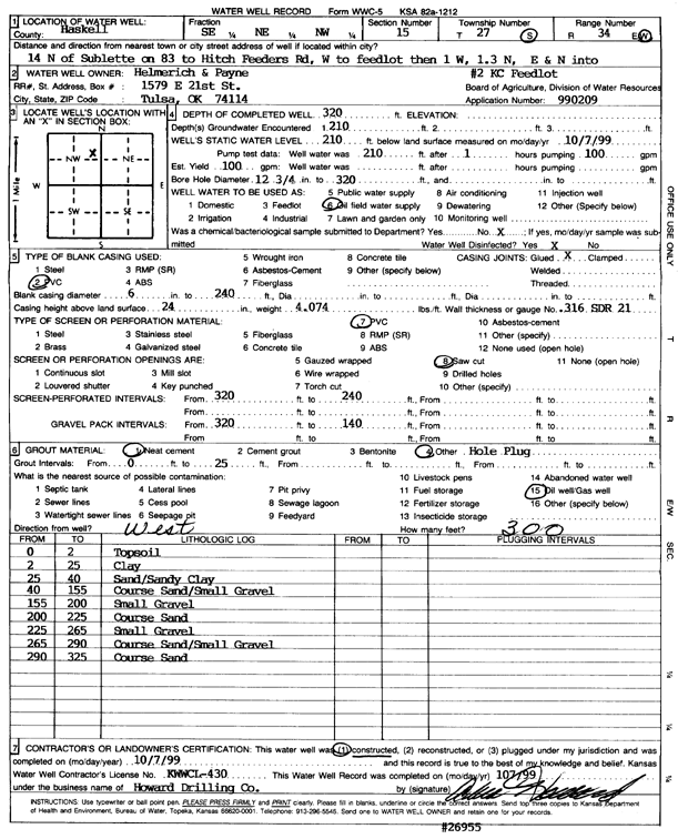
T27S, R34W, Sec. 15 SE NE NW |
Helmerich and Payne Inc. | 320 ft. | 210 ft. | Oil Field Water Supply | KC Feedlot 2 | Plugged | 03-Nov-1999 | Scan | |
|
T27S, R34W, Sec. 15 SE NE NW |
Helmerich and Payne Inc. | 320 ft. | 210 ft. | 100 gpm. | Oil Field Water Supply | KC Feedlot 2 | Constructed | 07-Oct-1999 | Scan |
|
T27S, R34W, Sec. 15 NW NW SW |
Helmerich and Payne Inc. | 360 ft. | 202 ft. | Domestic | Constructed | 23-Jan-1992 | |||
|
T27S, R34W, Sec. 15 SE NE SE |
Hugoton Energy Corp. | 320 ft. | 182 ft. | 100 gpm. | Oil Field Water Supply | Constructed | 31-Dec-1990 | Scan | |
|
T27S, R34W, Sec. 15 W2 NE SW |
Oxy USA, Inc. | 320 ft. | 180 ft. | Oil Field Water Supply | Plugged | 30-May-1991 | |||
|
T27S, R34W, Sec. 15 W2 NE SW |
Oxy USA, Inc. | 320 ft. | 180 ft. | 85 gpm. | Oil Field Water Supply | Snider B 2 | Constructed | 21-Mar-1991 | |
|
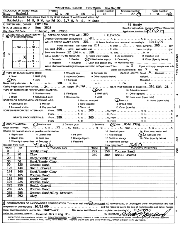
T27S, R34W, Sec. 15 E2 NE SW |
Oxy USA, Inc. | 380 ft. | 201 ft. | 100 gpm. | Oil Field Water Supply | Moody 1 | Constructed | 11-Oct-1999 | Scan |
|
T27S, R34W, Sec. 15 C SE NW |
Service Drilling Co | 280 ft. | 152 ft. | 95 gpm. | Oil Field Water Supply | Constructed | 11-Aug-1990 | ||
|
T27S, R34W, Sec. 15 C SE NW |
Service Drilling Co | 280 ft. | 152 ft. | Oil Field Water Supply | Plugged | 03-Dec-1990 | |||
|
T27S, R34W, Sec. 16 SE |
Kuhn Estate | 370 ft. | 175 ft. | 1710 gpm. | Irrigation | Constructed | 28-Jun-1982 | ||
|
T27S, R34W, Sec. 16 SE |
Lewis, Tommy | 369 ft. | 175 ft. | Domestic | Constructed | 11-May-1982 | |||
|
T27S, R34W, Sec. 17 NW SW |
Lewis, Tommy | 475 ft. | 161 ft. | 1500 gpm. | Irrigation | Constructed | 28-May-1979 | ||
|
T27S, R34W, Sec. 17 SW SW SW |
Tunis, Melvin | 422 ft. | 172 ft. | 45 gpm. | Domestic | Constructed | 28-Oct-1976 | ||
|
T27S, R34W, Sec. 17 SW SW SE |
Tunis, Melvin | 490 ft. | 168 ft. | 2500 gpm. | Irrigation | Constructed | 03-Jul-1980 | ||
|
T27S, R34W, Sec. 18 SE NW SW SW |
Nightengale, Jerrell | 655 ft. | 284 ft. | Irrigation | Constructed | 03-Apr-2008 | |||
|
T27S, R34W, Sec. 19 SW SE |
Fross, Ambrose | 420 ft. | Domestic | Constructed | 01-Jul-1988 | ||||
|
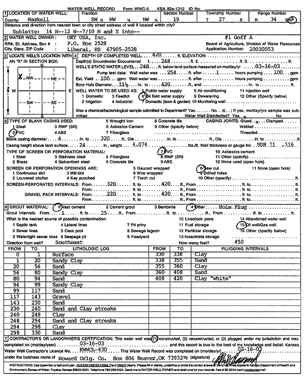
T27S, R34W, Sec. 19 SW NW NW |
Oxy USA, Inc. | 420 ft. | 248 ft. | 100 gpm. | Oil Field Water Supply | Goff A 1 | Constructed | 16-Mar-2003 | Scan |
|
T27S, R34W, Sec. 20 SW SW NW |
Melvin Tunis Estate | 485 ft. | 263 ft. | Irrigation | Constructed | 17-Jun-1996 | |||
|
T27S, R34W, Sec. 20 SW NE NE |
Tunas, Melvin | 340 ft. | 217 ft. | 90 gpm. | Oil Field Water Supply | Davatz D 3 | Plugged | 22-Dec-1987 | |
|
T27S, R34W, Sec. 20 SW NE NE |
Tunas, Melvin | 340 ft. | 217 ft. | 90 gpm. | Oil Field Water Supply | Davatz D 2 | Constructed | 06-Nov-1987 | |
|
T27S, R34W, Sec. 20 C NE |
Tunis, Melvin | 416 ft. | 170 ft. | 1404 gpm. | Irrigation | Constructed | 05-Mar-1975 | ||
|
T27S, R34W, Sec. 21 NE SW NE |
Alexander, Danny | 455 ft. | 250 ft. | Irrigation | Constructed | 08-Apr-1998 | |||
|
T27S, R34W, Sec. 21 SE SE SE |
Kells, Nathan | 540 ft. | 324 ft. | 50 gpm. | Domestic | Constructed | 13-Apr-2015 | ||
|
T27S, R34W, Sec. 21 SE SE NW SE |
Meyers, Bob | 560 ft. | 290 ft. | 500 gpm. | Irrigation | Constructed | 19-Dec-2012 |
KOLAR |
|
|
T27S, R34W, Sec. 21 SW SW NE |
Oxy USA, Inc. | 300 ft. | 200 ft. | Oil Field Water Supply | Garrison A 1 | Plugged | 09-Feb-1995 | ||
|
T27S, R34W, Sec. 22 NE NE SW SW |
Deseret Cattle Feeders | 527 ft. | 332 ft. | 85 gpm. | Irrigation | Constructed | 06-Jan-2016 |
KOLAR |
|
|
T27S, R34W, Sec. 22 SW NW NW |
Engler, Bill Sr. | 360 ft. | 190 ft. | 15 gpm. | Domestic | Constructed | 15-Sep-1982 | ||
|
T27S, R34W, Sec. 22 NE SE NE |
Oliver, Manley T. | 450 ft. | 200 ft. | Domestic | Constructed | 17-Dec-1982 | |||
|
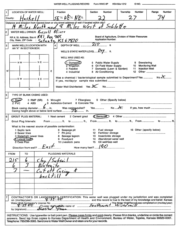
T27S, R34W, Sec. 22 SE NE NE |
Oliver, Russell | 215 ft. | Domestic | Plugged | 29-Aug-2000 | Scan | |||
|
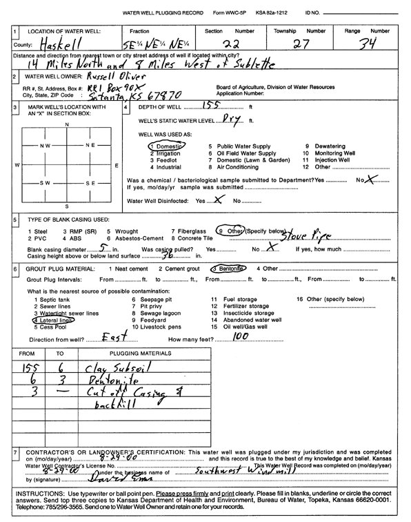
T27S, R34W, Sec. 22 SE NE NE |
Oliver, Russell | 155 ft. | Domestic | Plugged | 29-Aug-2000 | Scan | |||
|
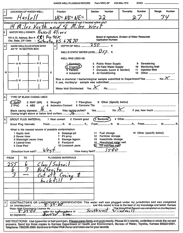
T27S, R34W, Sec. 22 NE NE NE |
Oliver, Russell | 255 ft. | Irrigation | Plugged | 29-Aug-2000 | Scan | |||
|
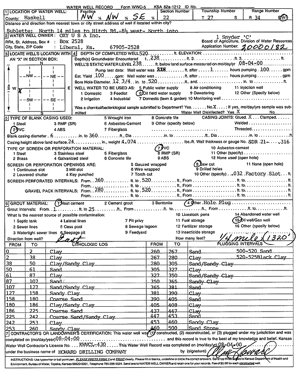
T27S, R34W, Sec. 22 NW NW SE |
Oxy USA, Inc. | 520 ft. | 238 ft. | 100 gpm. | Oil Field Water Supply | Snyder C 1 | Constructed | 04-Aug-2000 | Scan |
|
T27S, R34W, Sec. 22 NE NW SW |
Shotton, Ronald | 283 ft. | 176 ft. | 1550 gpm. | Irrigation | Constructed | 15-Oct-1975 | ||
|
T27S, R34W, Sec. 22 NE SW SW |
Shotton, Ronald J. | 566 ft. | 242 ft. | 200 gpm. | Irrigation | Constructed | 24-May-1993 | ||
| View page: < Prev || 11 || 12 || 13 || 14 || 15 || 16 || 17 || 18 || 19 || 20 || Next > | |||||||||