Select location of well to view details.
Click on column heading to sort.
|
|
|
County: Haskell Select location of well to view details. Click on column heading to sort. |
|
|
|
| View page: < Prev || 21 || 22 || 23 || 24 || 25 || 26 || 27 || 28 || 29 || 30 || Next > | |||||||||
| T-R-S | Owner | Well Depth Ascend. Desc. |
Static Water Level Ascend. Desc. |
Est. Yield Ascend. Desc. |
Well Use | Other ID | Action Taken | Completion Date Ascend. Desc. |
Scan? |
|
T29S, R31W, Sec. 12 NE SE SW |
Webber, Grant | 470 ft. | 280 ft. | Irrigation | Constructed | 15-Feb-2011 | |||
|
T29S, R31W, Sec. 13 SW SW SW SE |
Bryant, Michael | 502 ft. | 312 ft. | 1450 gpm. | Irrigation | Constructed | 09-Dec-2015 |
KOLAR |
|
|
T29S, R31W, Sec. 13 NW SW NW NE |
LPS Investment Group | 483 ft. | 326 ft. | 1484 gpm. | Irrigation | Constructed | 13-Mar-2015 |
KOLAR |
|
|
T29S, R31W, Sec. 13 NW NE SW |
Stude, Frank D | 544 ft. | 300 ft. | Irrigation | Constructed | 26-Jul-2011 | |||
|
T29S, R31W, Sec. 14 NE NE SE |
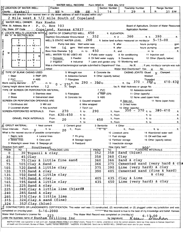
Koehn, Max | 450 ft. | 260 ft. | 16 gpm. | Domestic | Constructed | 16-May-2000 | Scan | |
|
T29S, R31W, Sec. 14 NE NW NW |
Wedel, Eugene | 481 ft. | 206 ft. | 2000 gpm. | Irrigation | Constructed | 06-Jun-1980 | ||
|
T29S, R31W, Sec. 14 NE SW NE |
Wesley Trust | 471 ft. | 198 ft. | 1435 gpm. | Irrigation | Constructed | 19-Oct-1976 | ||
|
T29S, R31W, Sec. 14 SE NW SW |
Withers, Lawrence | 435 ft. | 198 ft. | 2750 gpm. | Irrigation | Constructed | 06-Jul-1978 | ||
|
T29S, R31W, Sec. 15 NE NE NE |
Wedel, Eugene | 402 ft. | 190 ft. | 35 gpm. | Domestic | Constructed | 11-Oct-1976 | ||
|
T29S, R31W, Sec. 15 NE SE NE |
Wedel, Eugene | 310 ft. | 195 ft. | 70 gpm. | Domestic | Constructed | 22-Jan-1975 | ||
|
T29S, R31W, Sec. 15 NE NE NE SW |
Wedel, Eugene | 646 ft. | 312 ft. | 1119 gpm. | Irrigation | Constructed | 31-Jul-2014 |
KOLAR |
|
|
T29S, R31W, Sec. 15 NE NE NE |
Wedel, Eugene | 438 ft. | 193 ft. | 1451 gpm. | Irrigation | Constructed | 18-Oct-1976 | ||
|
T29S, R31W, Sec. 15 SE NE NE |
Wedel, Simon | 440 ft. | 270 ft. | 70 gpm. | Domestic | Constructed | 26-Dec-2008 | ||
|
T29S, R31W, Sec. 16 SE SE SW |
Withers, Lawrence | 628 ft. | 288 ft. | Irrigation | Constructed | 28-Jul-2011 | |||
|
T29S, R31W, Sec. 17 SE SE NE |
Sublette Feeders | 265 ft. | Monitoring well/observation/piezometer | MW 1 | Constructed | 28-Apr-1995 | |||
|
T29S, R31W, Sec. 17 NW NE NE |
Sublette Feeders | 631 ft. | 345 ft. | 150 gpm. | Feedlot | Constructed | 26-Oct-2023 |
KOLAR |
|
|
T29S, R31W, Sec. 17 SE SE NE |
Sublette Feeders | 256.5 ft. | 223 ft. | Monitoring well/observation/piezometer | MW 3 | Constructed | 09-May-1995 | ||
|
T29S, R31W, Sec. 17 NE NE SE |
Sublette Feeders | 590 ft. | 254 ft. | 25 gpm. | Domestic | Constructed | 18-Jul-1991 | ||
|
T29S, R31W, Sec. 17 SW SE NE |
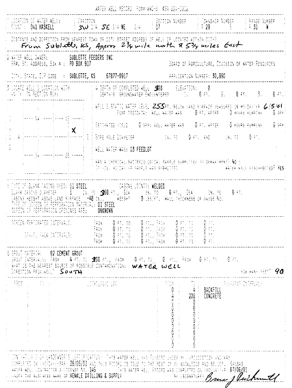
Sublette Feeders | 308 ft. | 255 ft. | Feedlot | Plugged | 05-Jun-2001 | Scan | ||
|
T29S, R31W, Sec. 17 SW SE NE |
Sublette Feeders | 622 ft. | 255 ft. | Feedlot | Constructed | 05-Apr-2001 | Scan | ||
|
T29S, R31W, Sec. 17 NW SE SE |
Sublette Feeders | 453 ft. | Domestic | Constructed | 08-Jun-1977 | ||||
|
T29S, R31W, Sec. 17 SE NW SE NE |
Sublette Feeders | 623 ft. | 280 ft. | 300 gpm. | Irrigation | Constructed | 15-Apr-2014 |
KOLAR |
|
|
T29S, R31W, Sec. 17 SE NE SE |
Sublette Feeders | 550 ft. | 345 ft. | 150 gpm. | Feedlot | Constructed | 24-Oct-2023 |
KOLAR |
|
|
T29S, R31W, Sec. 17 NW NE NW |
Sublette Feeders | 613 ft. | 220 ft. | 150 gpm. | Feedlot | Constructed | 13-Dec-1984 | ||
|
T29S, R31W, Sec. 17 NW NE NW |
Sublette Feeders | 463 ft. | 220 ft. | 150 gpm. | Feedlot | Constructed | 20-Dec-1984 | ||
|
T29S, R31W, Sec. 17 SE SE NE |
Sublette Feeders | 265 ft. | Monitoring well/observation/piezometer | MW 1 | Constructed | 28-Apr-1995 | |||
|
T29S, R31W, Sec. 17 SE SE NE |
Sublette Feeders | 260 ft. | 236.6 ft. | Monitoring well/observation/piezometer | MW 2 | Constructed | 28-Apr-1995 | ||
|
T29S, R31W, Sec. 18 SW NW NW |
Riphahn, Barbara | 400 ft. | 347 ft. | Irrigation | Plugged | 21-Oct-2024 |
KOLAR |
||
|
T29S, R31W, Sec. 18 NW SW NW |
Riphahn, Barbara | 676 ft. | 338 ft. | 600 gpm. | Irrigation | Constructed | 21-Sep-2022 |
KOLAR |
|
|
T29S, R31W, Sec. 18 SW NW NW |
Riphahn, Martin | 408 ft. | 196 ft. | 1420 gpm. | Irrigation | Constructed | 20-Dec-1975 | ||
|
T29S, R31W, Sec. 19 SW SW NW |
Bishop, Jim | 320 ft. | 220 ft. | 30 gpm. | Domestic | Constructed | 12-May-1986 | ||
|
T29S, R31W, Sec. 19 NE SW NW |
Cline, Robby | 500 ft. | 290 ft. | 75 gpm. | Domestic | Constructed | 18-Feb-2010 | ||
|
T29S, R31W, Sec. 19 SW SW NW |
Cline, Robby | 320 ft. | 294 ft. | Domestic | Plugged | 22-Feb-2010 | |||
|
T29S, R31W, Sec. 19 SW NW NW |
Fowler, Brett | 420 ft. | 302 ft. | 16 gpm. | Domestic | Constructed | 21-Jun-2010 | ||
|
T29S, R31W, Sec. 19 SE SW SW SW |
Sherwood, Michael | 480 ft. | 328 ft. | 1003 gpm. | Irrigation | Constructed | 06-May-2014 |
KOLAR |
|
|
T29S, R31W, Sec. 19 NW NW SW |
Sherwood, Mike | 360 ft. | 213 ft. | Domestic | Constructed | 12-Oct-1978 | |||
|
T29S, R31W, Sec. 19 NW NW NW |
Sherwood, Mike | 425 ft. | 195 ft. | Irrigation | Constructed | 23-Jul-1975 | |||
|
T29S, R31W, Sec. 19 NW SW SW |
Sherwood, Mike | 412 ft. | 226 ft. | 2000 gpm. | Irrigation | Constructed | 31-Jan-1979 | ||
|
T29S, R31W, Sec. 19 SW SW NW |
Stapleton, Shawn | 440 ft. | 292 ft. | 55 gpm. | Domestic | Constructed | 12-Sep-2005 | ||
|
T29S, R31W, Sec. 19 NW NW NW |
Whitaker, Bruce | 430 ft. | Domestic | Constructed | 18-Feb-2011 | ||||
|
T29S, R31W, Sec. 20 NE NE SW |
Bolton, Bill | 401 ft. | 203 ft. | 50 gpm. | Domestic | Constructed | 11-May-1983 | ||
|
T29S, R31W, Sec. 20 S2 SE NE NE |
Sublette Feeders | 648 ft. | 304 ft. | 25 gpm. | Domestic, Livestock | Constructed | 14-Jan-2015 |
KOLAR |
|
|
T29S, R31W, Sec. 20 NE NE NE |
Wedel, Viola | 355 ft. | 210 ft. | 50 gpm. | Domestic | Constructed | 20-Jun-1984 | ||
|
T29S, R31W, Sec. 21 SE SW SW SW |
E. and H. Koehn; W. E. and J. K. Schrepel Trust; M. A. Miller Rev. Trust | 625 ft. | 296 ft. | 600 gpm. | Irrigation | Constructed | 04-May-2016 |
KOLAR |
|
|
T29S, R31W, Sec. 21 NE NE SE |
Koehn, Emery | 353 ft. | 268 ft. | Irrigation | Plugged | 25-May-2004 | |||
|
T29S, R31W, Sec. 21 NE NE SE |
Koehn, Emery | 406 ft. | 265 ft. | Irrigation | Constructed | 17-Oct-2002 | Scan | ||
|
T29S, R31W, Sec. 21 NW NE NE SE |
Koehn, Emery | 623 ft. | 308 ft. | 517 gpm. | Irrigation | Constructed | 15-Aug-2014 |
KOLAR |
|
|
T29S, R31W, Sec. 21 SE SE SW |
Koehn, Emery | 432 ft. | 271 ft. | Irrigation | Constructed | 05-May-2008 | |||
|
T29S, R31W, Sec. 21 SE SE SW |
Koehn, Jonas | 370 ft. | 180 ft. | 1440 gpm. | Irrigation | Constructed | 05-May-1975 | ||
|
T29S, R31W, Sec. 21 C NE |
Wedel, Gene | 367 ft. | 180 ft. | 1200 gpm. | Irrigation | Constructed | 31-Dec-1974 | ||
| View page: < Prev || 21 || 22 || 23 || 24 || 25 || 26 || 27 || 28 || 29 || 30 || Next > | |||||||||