Select location of well to view details.
Click on column heading to sort.
|
|
|
County: Haskell Select location of well to view details. Click on column heading to sort. |
|
|
|
| View page: < Prev || 41 || 42 || 43 || 44 || 45 || 46 | |||||||||
| T-R-S | Owner | Well Depth Ascend. Desc. |
Static Water Level Ascend. Desc. |
Est. Yield Ascend. Desc. |
Well Use | Other ID | Action Taken | Completion Date Ascend. Desc. |
Scan? |
|
T30S, R33W, Sec. 22 NE NE SW |
Berexco Inc | 500 ft. | 197 ft. | 50 gpm. | Oil Field Water Supply | Jolynn 1-22 | Constructed | 12-Jul-1996 | |
|
T30S, R33W, Sec. 22 SW NE SW |
Harlow, Henry | 455 ft. | 245 ft. | 1150 gpm. | Irrigation | Constructed | 16-Oct-1975 | ||
|
T30S, R33W, Sec. 22 NE SE NW SE |
Klaus, Greg | 500 ft. | Domestic | Constructed | 04-May-2011 | ||||
|
T30S, R33W, Sec. 22 C SE NW |
Leonard, Risa | 610 ft. | 315 ft. | Irrigation | Constructed | 13-Sep-1991 | |||
|
T30S, R33W, Sec. 23 NE NE NE |
King, Bill | 480 ft. | 278 ft. | 100 gpm. | Oil Field Water Supply | Constructed | 07-Aug-2012 | ||
|
T30S, R33W, Sec. 23 SE NE NE SE |
Oxy USA, Inc. | 480 ft. | 348 ft. | 90 gpm. | Oil Field Water Supply | Wilson F 1 | Constructed | 30-Jun-2011 | |
|
T30S, R33W, Sec. 23 NW NE SW |
Taylor, Bill | 520 ft. | 289 ft. | Irrigation | Constructed | 17-May-1990 | |||
|
T30S, R33W, Sec. 23 SE NW NW |
Taylor, Wanda | 390 ft. | 340 ft. | Irrigation | Plugged | 28-Apr-2003 | |||
|
T30S, R33W, Sec. 24 NE SW SW |
Hines Farms | 645 ft. | 348 ft. | Irrigation | Constructed | 08-Nov-2008 | |||
|
T30S, R33W, Sec. 24 SE SE NE |
Leonard, Floyd Jr. | 615 ft. | 234 ft. | 1707 gpm. | Irrigation | Constructed | 01-Nov-1975 | ||
|
T30S, R33W, Sec. 24 SE SE NE |
Miller, Mr. Bill | 400 ft. | 250 ft. | 20 gpm. | Domestic | Constructed | 05-Nov-1987 | ||
|
T30S, R33W, Sec. 24 SE SE SE |
Stapelton, Clifford | 410 ft. | 260 ft. | 30 gpm. | Domestic | Constructed | 20-Sep-1980 | ||
|
T30S, R33W, Sec. 25 SE SE |
Chaffin, J. H. | 406 ft. | 210 ft. | 1200 gpm. | Irrigation | Constructed | 31-Mar-1975 | ||
|
T30S, R33W, Sec. 25 SE SW SE |
W.E. Land and Cattle | 485 ft. | 302 ft. | Irrigation | Constructed | 10-Mar-2009 | |||
|
T30S, R33W, Sec. 25 NE SW NE |
W.E. Land and Cattle | 652 ft. | 356 ft. | Irrigation | Constructed | 03-Mar-2022 |
KOLAR |
||
|
T30S, R33W, Sec. 25 NE NW NE SE |
Wright, Gene | 402 ft. | 347 ft. | Irrigation | Plugged | 28-Feb-2022 |
KOLAR |
||
|
T30S, R33W, Sec. 26 NW NE NW |
Dekalb Agri Research | 402 ft. | 256 ft. | Domestic | Constructed | 03-May-1982 | |||
|
T30S, R33W, Sec. 26 SE SE NW NW |
Fry Family Farms | 629 ft. | 348 ft. | 500 gpm. | Irrigation | Constructed | 22-Sep-2015 |
KOLAR |
|
|
T30S, R33W, Sec. 27 SE |
Greeson, Jim | 460 ft. | 273 ft. | Irrigation | Constructed | 27-Jun-1991 | |||
|
T30S, R33W, Sec. 27 NW NW NE |
Haskell Land Co | 606 ft. | 240 ft. | 1451 gpm. | Irrigation | Constructed | 07-Oct-1976 | ||
|
T30S, R33W, Sec. 27 NE SW SW |
Oxy USA, Inc. | 440 ft. | 315 ft. | 100 gpm. | Oil Field Water Supply | Filler 4 27 | Constructed | 06-Oct-2008 | |
|
T30S, R33W, Sec. 28 C SW SW |
Oxy USA, Inc. | 420 ft. | 295 ft. | 95 gpm. | Oil Field Water Supply | 3 Hickman B | Constructed | 05-Apr-1995 | |
|
T30S, R33W, Sec. 29 NW NW NE |
Blair, Marion | 400 ft. | 239 ft. | 60 gpm. | Domestic | Constructed | 03-Sep-1975 | ||
|
T30S, R33W, Sec. 29 SE SE SW |
Lucas, Ron and Shirley | 603 ft. | 235 ft. | 1800 gpm. | Irrigation | Constructed | 19-Jul-1977 | ||
|
T30S, R33W, Sec. 29 C NE SE |
Oxy USA, Inc. | 420 ft. | 240 ft. | 100 gpm. | Oil Field Water Supply | 1 Blair F | Constructed | 28-Sep-1995 | |
|
T30S, R33W, Sec. 29 SE SE SE |
Oxy USA, Inc. | 420 ft. | 245 ft. | 80 gpm. | Oil Field Water Supply | Blair 1 | Constructed | 23-Sep-1996 | |
|
T30S, R33W, Sec. 29 C NE SE |
Oxy USA, Inc. | 420 ft. | 240 ft. | Oil Field Water Supply | 1 Blair F | Plugged | 15-Dec-1995 | ||
|
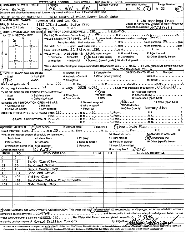
T30S, R33W, Sec. 30 NE NW NW |
Harris Oil and Gas Co. | 430 ft. | 267 ft. | Oil Field Water Supply | Nanninga Trust 1-430 | Constructed | 07-May-2001 | Scan | |
|
T30S, R33W, Sec. 30 SE NE NW |
Presco Western LLC | 460 ft. | 312 ft. | 100 gpm. | Oil Field Water Supply | SWLVLU I 14 | Constructed | 12-Jun-2007 | |
|
T30S, R33W, Sec. 30 NW NW SW |
Stalker, Brad | 400 ft. | 300 ft. | Irrigation | Plugged | 30-Jan-2003 | |||
|
T30S, R33W, Sec. 30 NE NW SE |
Stalker, Brad | 390 ft. | 225 ft. | 50 gpm. | Domestic | Constructed | 28-Mar-1998 | ||
|
T30S, R33W, Sec. 30 NW SE SW |
Stalker, Elisa | 615 ft. | 308 ft. | Irrigation | Constructed | 19-Dec-2001 | Scan | ||
|
T30S, R33W, Sec. 31 NW NW NW |
Ensign Operating Co. | 420 ft. | 265 ft. | 120 gpm. | Oil Field Water Supply | Constructed | 27-Jul-1990 | ||
|
T30S, R33W, Sec. 31 NW NW SW |
Withers, Charles | 503 ft. | 226 ft. | 1400 gpm. | Irrigation | Constructed | 26-Nov-1976 | ||
|
T30S, R33W, Sec. 31 NW NW NW SW |
Withers, Charles | 603 ft. | 346 ft. | 1201 gpm. | Irrigation | Constructed | 02-Dec-2017 |
KOLAR |
|
|
T30S, R33W, Sec. 32 C NW NE |
Cities Service | 360 ft. | 232 ft. | 60 gpm. | Oil Field Water Supply | Arbuthnot A 2 | Constructed | 01-Jun-1984 | |
|
T30S, R33W, Sec. 32 NW NE |
Cities Service | 360 ft. | 232 ft. | 60 gpm. | Oil Field Water Supply | Arbuthnot A 2 | Plugged | 23-Dec-1986 | |
|
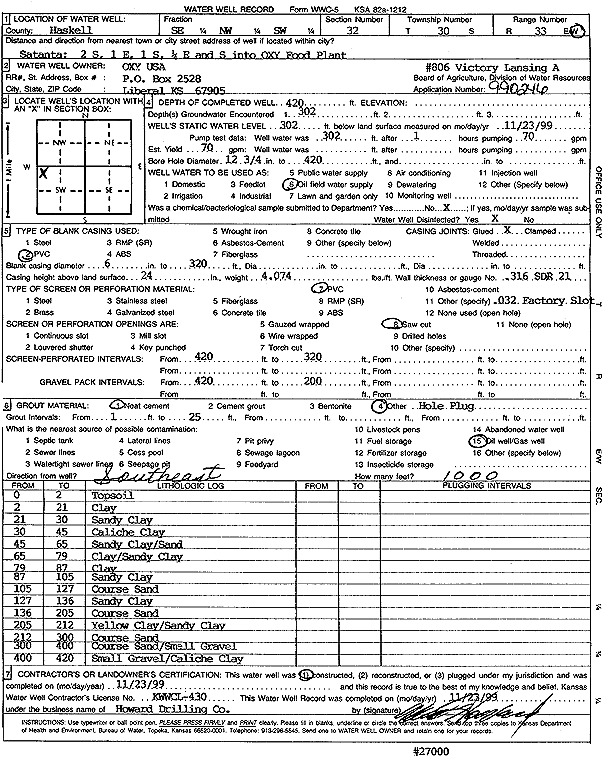
T30S, R33W, Sec. 32 SE NW SW |
Oxy USA, Inc. | 420 ft. | 302 ft. | 70 gpm. | Oil Field Water Supply | Victory Lansing A 806 | Constructed | 23-Nov-1999 | Scan |
|
T30S, R33W, Sec. 32 NE NE NE |
Oxy USA, Inc. | 400 ft. | 280 ft. | Oil Field Water Supply | Arbuthnot A 6 | Plugged | 03-Sep-1996 | ||
|
T30S, R33W, Sec. 32 NE NE NE |
Oxy USA, Inc. | 400 ft. | 280 ft. | 100 gpm. | Industrial | Arbuthnot A 6 | Constructed | 10-Feb-1996 | |
|
T30S, R33W, Sec. 33 NE SW SW |
Homsher, Peggy J | 340 ft. | 247 ft. | Oil Field Water Supply | Constructed | 16-Aug-1993 | |||
|
T30S, R33W, Sec. 33 S2 SE NW |
Homsher, Peggy/Murfin Drilling | 385 ft. | 339 ft. | Oil Field Water Supply | Constructed | 28-Nov-1994 | |||
|
T30S, R33W, Sec. 33 C NE NW |
Hugoton Energy | 400 ft. | 250 ft. | 100 gpm. | Oil Field Water Supply | Homsher 7-33 | Constructed | 18-Aug-1995 | |
|
T30S, R33W, Sec. 34 NE NW NE |
Beredco Inc | 420 ft. | 300 ft. | 100 gpm. | Oil Field Water Supply | Constructed | 22-Nov-1989 | ||
|
T30S, R33W, Sec. 34 NW NW NW |
Nation Properties LLC | 296 ft. | Oil Field Water Supply | Plugged | 13-Aug-2009 | ||||
|
T30S, R33W, Sec. 36 NE |
Miller, Bill | 400 ft. | 235 ft. | 1500 gpm. | Irrigation | Constructed | 11-Sep-1979 | ||
|
T30S, R33W, Sec. 36 NE NW NW |
Wright, Gene | 600 ft. | 343 ft. | Irrigation | Constructed | 17-Oct-2024 |
KOLAR |
||
|
T30S, R34W, Sec. 1 NE NE SW |
Withers, Charles and Carolyn | 660 ft. | 368 ft. | 350 gpm. | Irrigation | Constructed | 18-Dec-2024 |
KOLAR |
|
|
T30S, R34W, Sec. 2 SE NE SW |
Black, Dennis | 435 ft. | 337 ft. | Irrigation | Constructed | 13-Jun-2003 | Scan | ||
|
T30S, R34W, Sec. 2 SW SW NE |
C. M. Light Estate/Murfin Drilling | 440 ft. | 285 ft. | Oil Field Water Supply | Plugged | 20-Apr-1998 | |||
| View page: < Prev || 41 || 42 || 43 || 44 || 45 || 46 | |||||||||