Select location of well to view details.
Click on column heading to sort.
|
|
|
County: Decatur Select location of well to view details. Click on column heading to sort. |
|
|
|
| View page: 1 || 2 || 3 || 4 || 5 || 6 || 7 || 8 || 9 || 10 || Next > | |||||||||
| T-R-S | Owner | Well Depth Ascend. Desc. |
Static Water Level Ascend. Desc. |
Est. Yield Ascend. Desc. |
Well Use | Other ID | Action Taken | Completion Date Ascend. Desc. |
Scan? |
|
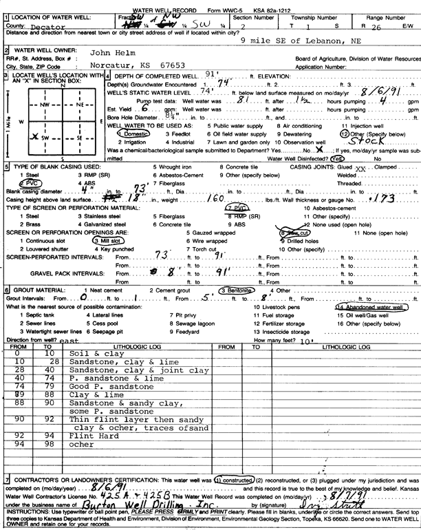
T1S, R26W, Sec. 2 SW NW SW |
Helm, John | 91 ft. | 74 ft. | 6 gpm. | Domestic, Livestock | Constructed | 06-Aug-1991 | Scan | |
|
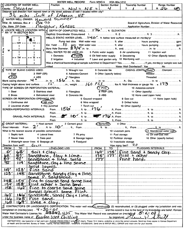
T1S, R26W, Sec. 4 NW NE |
Sumner, Howard | 176 ft. | 140 ft. | 10 gpm. | Feedlot | Constructed | 30-Apr-2001 | Scan | |
|
T1S, R26W, Sec. 5 NE SW SE SE |
Huff, Eldon | 83 ft. | 40 ft. | 10 gpm. | Domestic, Livestock | Constructed | 07-Nov-2012 | ||
|
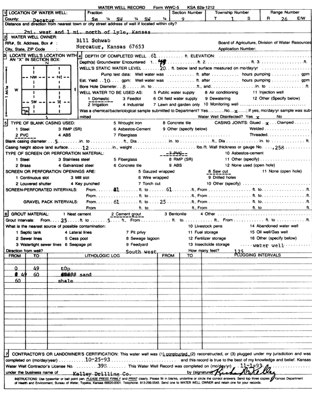
T1S, R26W, Sec. 9 SE SW SW |
Schwab, Bill | 61 ft. | 20 ft. | 10 gpm. | Domestic | Constructed | 25-Oct-1993 | Scan | |
|
T1S, R26W, Sec. 10 SE SE NW NW |
Huff, Donna | 65 ft. | 52 ft. | 4 gpm. | Domestic, Livestock | Constructed | 22-Mar-2014 | ||
|
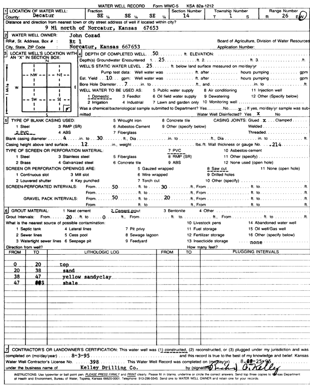
T1S, R26W, Sec. 14 SE SE SE |
Cozad, John | 50 ft. | 25 ft. | 10 gpm. | Domestic | Constructed | 03-Aug-1995 | Scan | |
|
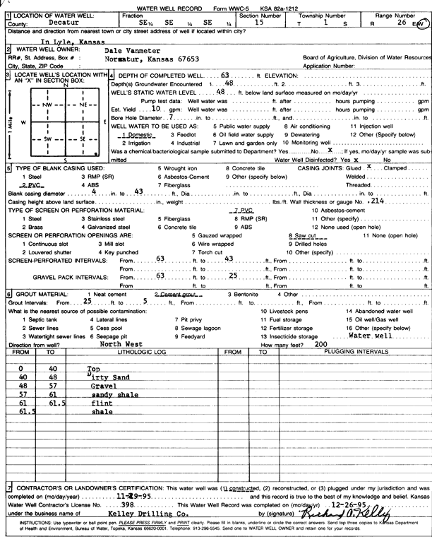
T1S, R26W, Sec. 15 SE SE SE |
Vanmeter, Dale | 63 ft. | 48 ft. | 10 gpm. | Domestic | Constructed | 29-Nov-1995 | Scan | |
|
T1S, R26W, Sec. 16 SE SE SW |
Huff, Eldon | 42 ft. | 36 ft. | Irrigation | Plugged | 16-Oct-2007 | |||
|
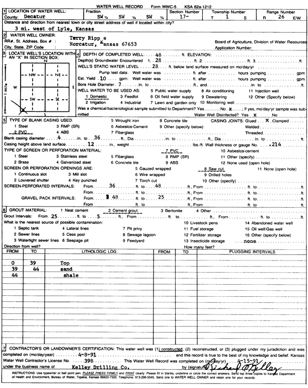
T1S, R26W, Sec. 17 SW SW SW |
Rippe, Terry | 48 ft. | 28 ft. | 10 gpm. | Domestic | Constructed | 08-Apr-1991 | Scan | |
|
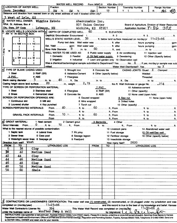
T1S, R26W, Sec. 17 NW SW SW |
Wiggins Estate/Abercrombie Inc. | 60 ft. | 38 ft. | Oil Field Water Supply | Constructed | 23-Nov-1986 | Scan | ||
|
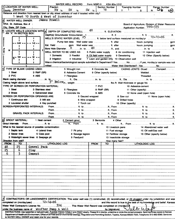
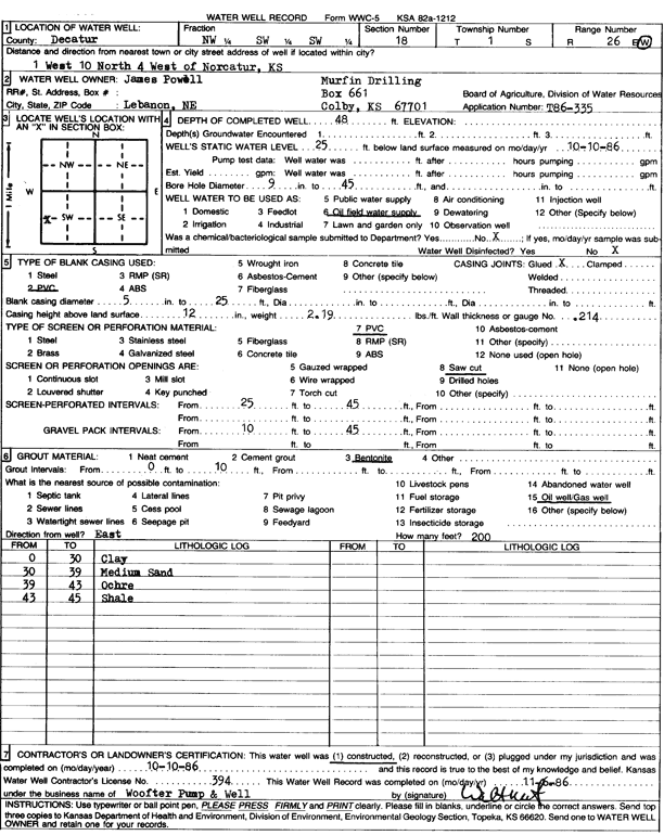
T1S, R26W, Sec. 18 NW SW SW |
Murfin Drilling/James Powell | 48 ft. | 25 ft. | Oil Field Water Supply | Plugged | 14-Dec-1986 | Scan | ||
|
T1S, R26W, Sec. 18 NW SW SW |
Murfin Drilling/James Powell | 48 ft. | 25 ft. | Oil Field Water Supply | Constructed | 10-Oct-1986 | Scan | ||
|
T1S, R26W, Sec. 19 SW NW NW |
Wilson, Roger | 75 ft. | 30 ft. | 10 gpm. | Domestic | Constructed | 21-Mar-2008 | ||
|
T1S, R26W, Sec. 19 NE NE NE |
Wilson, Roger | 54 ft. | 30 ft. | 10 gpm. | Domestic | Constructed | 11-Mar-2008 | ||
|
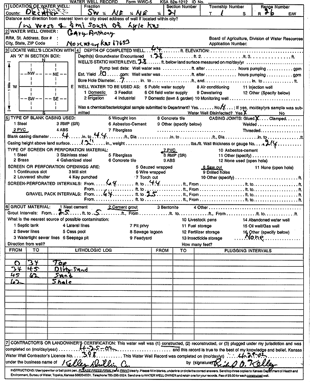
T1S, R26W, Sec. 21 SW NE NE |
Anthony, Gary | 64 ft. | 28 ft. | 10 gpm. | Domestic | Constructed | 25-Apr-2002 | Scan | |
|
T1S, R26W, Sec. 21 NE NE NW SE |
Stapp, Dewaine (was Mareyco Inc) | 30 ft. | 8 ft. | 40 gpm. | Domestic, changed from Oil Field Water Supply | Stapp Farms 34-21 | Constructed | 20-Jun-2012 |
KOLAR |
|
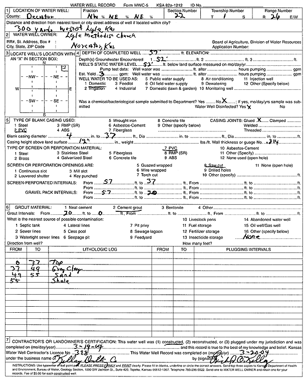
T1S, R26W, Sec. 22 NW NE NE |
Lyle Methodist Church | 57 ft. | 52 ft. | 3 gpm. | Domestic | Constructed | 19-Mar-2004 | Scan | |
|
T1S, R26W, Sec. 22 NW SW NW |
Mapes, Robert | 65 ft. | 37 ft. | 15 gpm. | Domestic | Constructed | 23-Aug-2004 | ||
|
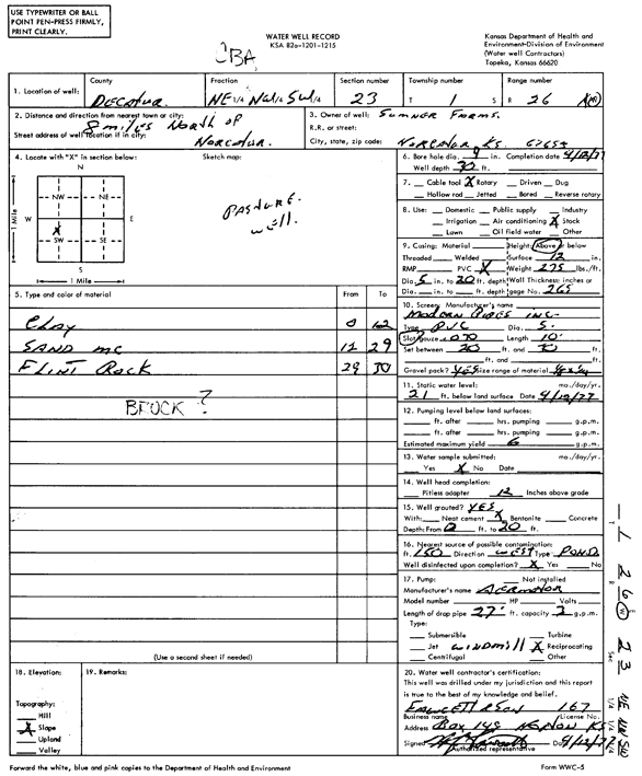
T1S, R26W, Sec. 23 NE NW SW |
Sumner Farms | 30 ft. | 21 ft. | 6 gpm. | Domestic, Livestock | Constructed | 12-Apr-1977 | Scan | |
|
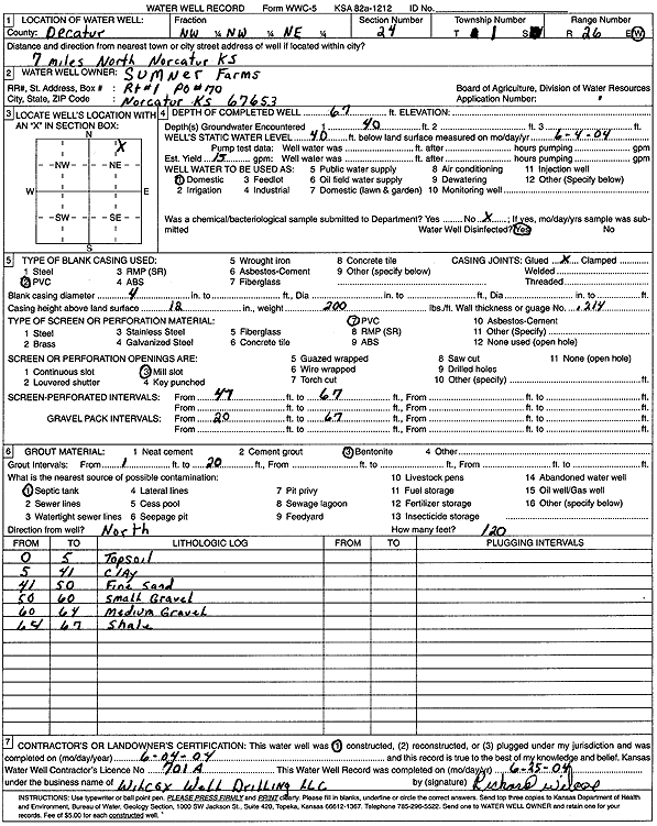
T1S, R26W, Sec. 24 NW NW NE |
Sumner Farms | 67 ft. | 40 ft. | 15 gpm. | Domestic | Constructed | 04-Jun-2004 | Scan | |
|
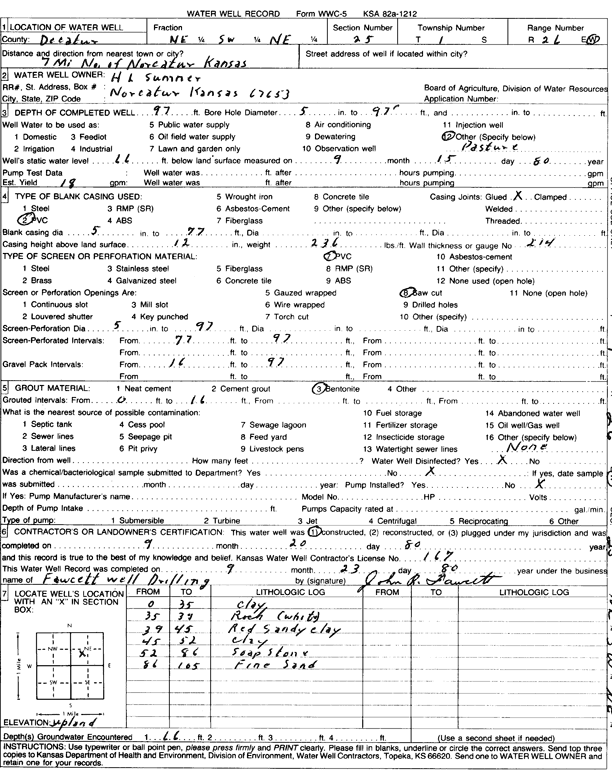
T1S, R26W, Sec. 25 NE SW NE |
Sumner, H.L. | 97 ft. | 66 ft. | 18 gpm. | Domestic, Livestock | Constructed | 20-Sep-1980 | Scan | |
|
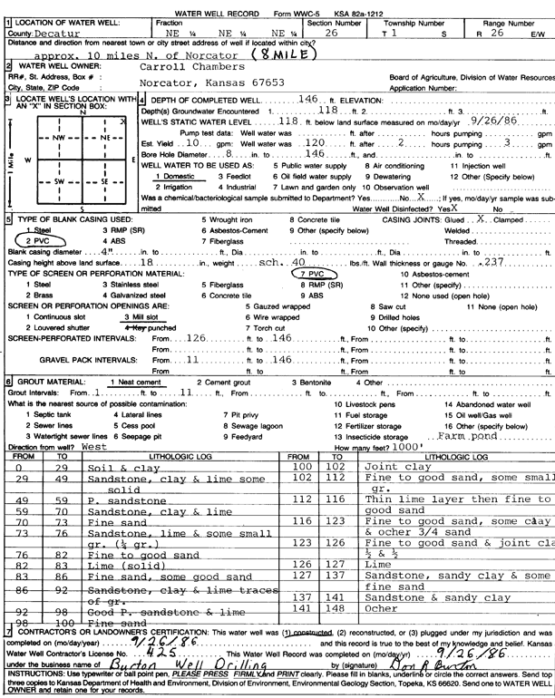
T1S, R26W, Sec. 26 NE NE NE |
Chambers, Carroll | 146 ft. | 118 ft. | 10 gpm. | Domestic | Constructed | 26-Sep-1986 | Scan | |
|
T1S, R26W, Sec. 26 SE SE SE |
Sumner Farms, Inc | 150 ft. | 119 ft. | 20 gpm. | Domestic | Constructed | 07-Sep-2004 | ||
|
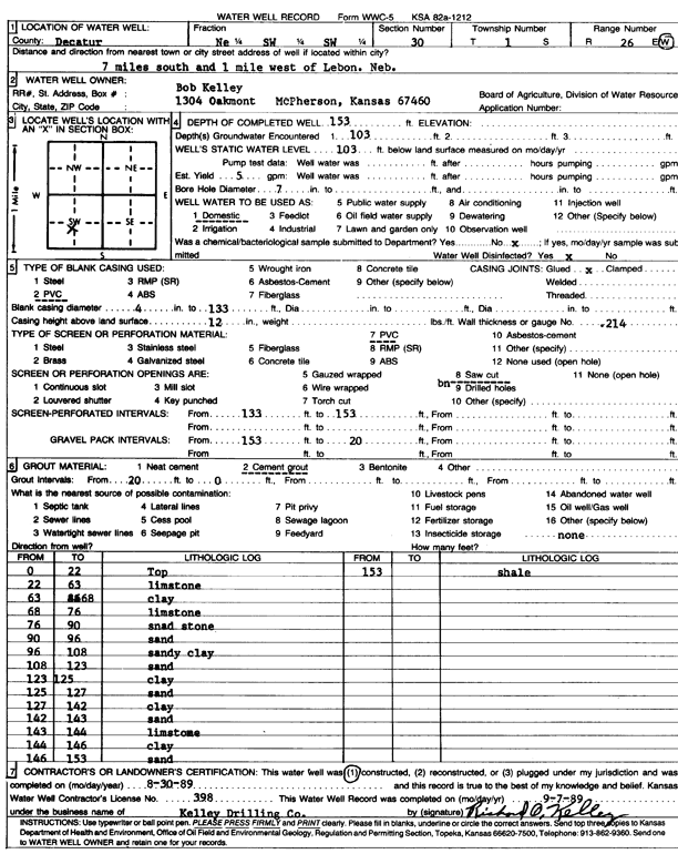
T1S, R26W, Sec. 30 NE SW SW |
Kelley, Bob | 153 ft. | 103 ft. | 5 gpm. | Domestic | Constructed | 30-Aug-1989 | Scan | |
|
T1S, R26W, Sec. 30 NE SW SW |
Murfin Drilling Co. | 175 ft. | 105 ft. | 50 gpm. | Oil Field Water Supply | Kelley 1-30 | Constructed | 14-Nov-2022 |
KOLAR |
|
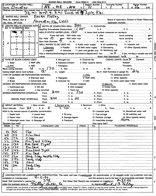
T1S, R26W, Sec. 31 NE NE NW |
Kelley, Brian | 200 ft. | 125 ft. | 10 gpm. | Domestic | Constructed | 11-Sep-2000 | Scan | |
|
T1S, R26W, Sec. 32 NW SW SW NW |
Grafel Farms | 40 ft. | 36 ft. | Domestic | Plugged | 20-Jul-2016 |
KOLAR |
||
|
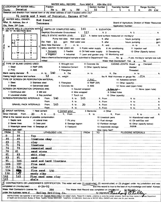
T1S, R26W, Sec. 32 NW SW NW |
Powell, Rod | 165 ft. | 117 ft. | 10 gpm. | Domestic | Constructed | 24-Jun-1992 | Scan | |
|
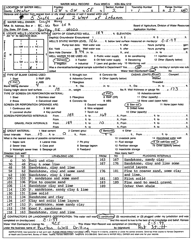
T1S, R27W, Sec. 2 SW SW SE |
Haag, Gayle | 189 ft. | 126 ft. | Domestic | Constructed | 01-Feb-1999 | Scan | ||
|
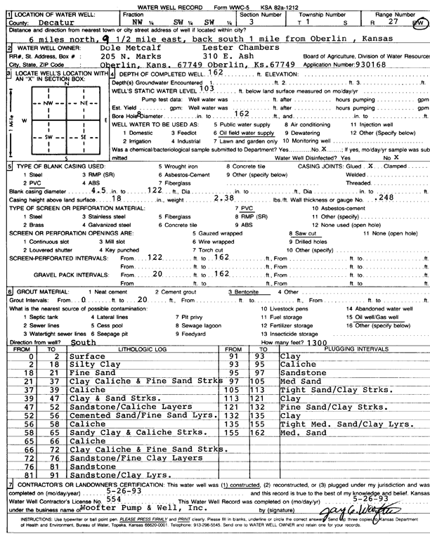
T1S, R27W, Sec. 3 NW SW SW |
Dole Metcalf/Lester Chambers | 162 ft. | 103 ft. | Oil Field Water Supply | Constructed | 26-May-1993 | Scan | ||
|
T1S, R27W, Sec. 3 NE NW NW |
Springer, Marlin | 217 ft. | 174 ft. | Domestic, Livestock | Constructed | 29-Jun-2000 | Scan | ||
|
T1S, R27W, Sec. 4 SE SW SE |
Wilson, Roger | 200 ft. | Oil Field Water Supply | Constructed | 07-Mar-2008 | ||||
|
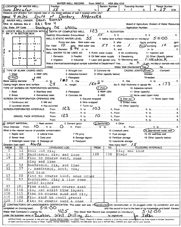
T1S, R27W, Sec. 8 SE |
Berndt, Dean | 123 ft. | 55 ft. | 10 gpm. | Domestic, Livestock | Constructed | 11-May-2000 | Scan | |
|
T1S, R27W, Sec. 9 N2 NE NE |
Hanchera, Scott | 190 ft. | Oil Field Water Supply | Constructed | 17-Oct-2008 | ||||
|
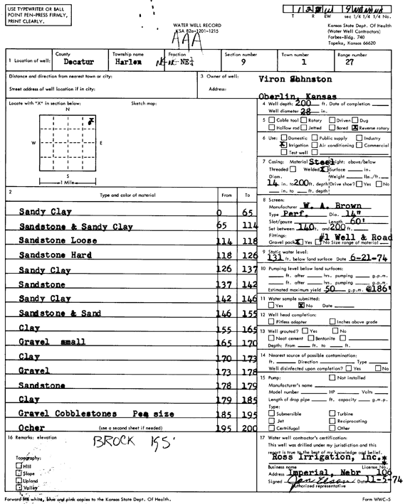
T1S, R27W, Sec. 9 NE NE NE |
Johnston, Viron | 200 ft. | 131 ft. | 50 gpm. | Irrigation | Constructed | 05-Nov-1974 | Scan | |
|
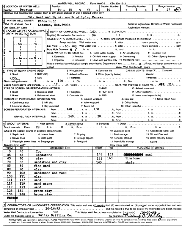
T1S, R27W, Sec. 10 SW SW NW |
Huff, Eldon | 160 ft. | 96 ft. | 10 gpm. | Domestic | Constructed | 16-Oct-1995 | Scan | |
|
T1S, R27W, Sec. 11 SE SW SE |
Chambers, Rick | 88 ft. | 24 ft. | 11 gpm. | Domestic | Constructed | 22-Jul-2022 |
KOLAR |
|
|
T1S, R27W, Sec. 12 SE SE |
M and L Trust | 138 ft. | 121 ft. | 3 gpm. | Domestic | Constructed | 12-Oct-2005 | ||
|
T1S, R27W, Sec. 14 SE SW SE |
Chambers, Rick | 95 ft. | 22 ft. | 10 gpm. | Domestic, Livestock | Constructed | 16-Sep-2022 |
KOLAR |
|
|
T1S, R27W, Sec. 15 SE SE NE SE |
Haff, Eldon | 90 ft. | 35 ft. | 10 gpm. | Domestic, Livestock | Constructed | 26-Mar-2014 | ||
|
T1S, R27W, Sec. 16 SW NE NW NW |
Hanchera, Scott and Kristy | 185 ft. | Oil Field Water Supply | Constructed | 31-Aug-2011 | ||||
|
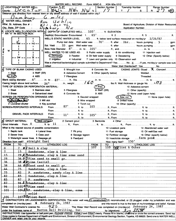
T1S, R27W, Sec. 17 SE NW NW |
Uehlin, Ron | 105 ft. | 65 ft. | 20 gpm. | Domestic | Constructed | 24-Feb-1987 | Scan | |
|
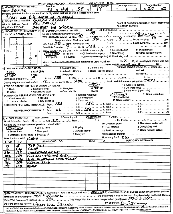
T1S, R27W, Sec. 19 SE NE SE |
Lafferty, Galen | 158 ft. | 89 ft. | 40 gpm. | Domestic | Constructed | 27-Mar-2002 | Scan | |
|
T1S, R27W, Sec. 20 SW NW NE NE |
Cathcart, William and Geraldine | 150 ft. | Oil Field Water Supply | Constructed | 09-Sep-2011 | ||||
|
T1S, R27W, Sec. 20 SE SE SE SE |
Crosley, Jim | 80 ft. | 56 ft. | Domestic, Livestock | Constructed | 08-Jun-2021 | |||
|
T1S, R27W, Sec. 23 NW SE SE NW |
Chamber Land LLC | 73 ft. | 28 ft. | 650 gpm. | Irrigation | Reconstructed | 06-Apr-2018 |
KOLAR |
|
|
T1S, R27W, Sec. 24 NE NW NE |
Rippo, Lynn | 54 ft. | 29 ft. | 10 gpm. | Domestic | Constructed | 27-Mar-2000 | Scan | |
|
T1S, R27W, Sec. 24 NW NW NW |
Wilson, Roger | 58 ft. | 28 ft. | 10 gpm. | Domestic | Constructed | 10-Mar-2008 | ||
|
T1S, R27W, Sec. 25 NW NW SW SE |
Huff, Eldon | 80 ft. | 38 ft. | 10 gpm. | Domestic, Livestock | Constructed | 02-Sep-2017 |
KOLAR |
|
|
T1S, R27W, Sec. 28 SW SE NW |
Metcalf, Shannon | 90 ft. | 76 ft. | Domestic | Constructed | 18-Jun-2012 | |||
| View page: 1 || 2 || 3 || 4 || 5 || 6 || 7 || 8 || 9 || 10 || Next > | |||||||||