Select location of well to view details.
Click on column heading to sort.
|
|
|
County: Morton Select location of well to view details. Click on column heading to sort. |
|
|
|
| View page: < Prev || 11 || 12 || 13 || 14 || 15 || 16 || 17 || 18 || 19 || 20 || Next > | |||||||||
| T-R-S | Owner | Well Depth Ascend. Desc. |
Static Water Level Ascend. Desc. |
Est. Yield Ascend. Desc. |
Well Use | Other ID | Action Taken | Completion Date Ascend. Desc. |
Scan? |
|
T34S, R41W, Sec. 35 SW NE NE |
Oxy USA, Inc. | 285 ft. | 160 ft. | 75 gpm. | Oil Field Water Supply | Engleman A 2 | Constructed | 14-Nov-1996 | |
|
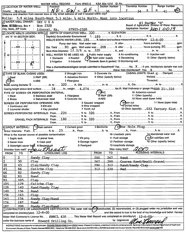
T34S, R41W, Sec. 36 NE SW SE |
Oxy USA, Inc. | 320 ft. | 185 ft. | 90 gpm. | Oil Field Water Supply | Barber B 3 | Constructed | 06-Dec-2000 | Scan |
|
T34S, R42W, Sec. 2 C NW |
Anadarko Petroleum Corp. | 240 ft. | 95 ft. | 50 gpm. | Oil Field Water Supply | Parflow A 1 | Constructed | 13-Oct-1981 | |
|
T34S, R42W, Sec. 2 C NW |
U.S. Forest Service | 268 ft. | 33 ft. | Domestic | A-6 | Plugged | 24-Sep-1992 | ||
|
T34S, R42W, Sec. 6 SW SW SE |
U.S Forest Service | 90 ft. | 10 ft. | 10 gpm. | Domestic | Constructed | 24-Jun-1996 | ||
|
T34S, R42W, Sec. 6 SW SW SE |
U.S. Forest Service | 80 ft. | 10 ft. | 10 gpm. | Domestic | Constructed | 22-Jun-1996 | ||
|
T34S, R42W, Sec. 7 C NW NW |
Anadarko Petroleum Corp. | 200 ft. | 45 ft. | 50 gpm. | Oil Field Water Supply | Interstate T 1 | Constructed | 17-Aug-1981 | |
|
T34S, R42W, Sec. 9 SE SE SE |
Cimarron Natural Grassland | 220 ft. | 70 ft. | 75 gpm. | Oil Field Water Supply | Government 2-9 | Constructed | 14-Aug-1986 | |
|
T34S, R42W, Sec. 11 C NW SE |
Anadarko Petroleum Corp. | 240 ft. | 90 ft. | 50 gpm. | Oil Field Water Supply | Durham A 1 | Constructed | 24-Oct-1981 | |
|
T34S, R42W, Sec. 12 C NW |
Cimarron National Grassland | Domestic, Livestock | Plugged | 25-Oct-1996 | |||||
|
T34S, R42W, Sec. 13 NE SW SW |
Cimarron National Grassland | 200 ft. | 85 ft. | 20 gpm. | Domestic, Livestock | Constructed | 18-Jan-1979 | ||
|
T34S, R42W, Sec. 14 C NE |
Morton County Grazing Assoc. | 160 ft. | 65 ft. | 30 gpm. | Domestic | Constructed | 14-Apr-1988 | ||
|
T34S, R42W, Sec. 14 C NE NW |
U.S. Forest Service | 124 ft. | 65 ft. | Domestic, Livestock | B-3 | Plugged | 12-Oct-1992 | ||
|
T34S, R42W, Sec. 15 NE NE SW |
Anadarko Petroleum Corp. | 180 ft. | 70 ft. | 60 gpm. | Oil Field Water Supply | State of Kansas A 1 | Constructed | 31-Jul-1984 | |
|
T34S, R42W, Sec. 15 NE NE NW |
U.S. Forest Service | 60 ft. | 55 ft. | Domestic, Livestock | Plugged | 25-Jul-1991 | |||
|
T34S, R42W, Sec. 16 C NW SE |
Cimarron National Grassland | 20 ft. | (unstated)/abandoned | Plugged | 21-Oct-1997 | ||||
|
T34S, R42W, Sec. 16 NW NW NE |
Oxy USA, Inc. | 350 ft. | 90 ft. | Oil Field Water Supply | Santa Fe C 3 | Plugged | 13-Apr-2000 | Scan | |
|
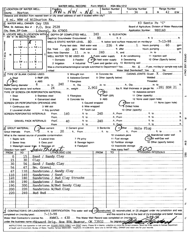
T34S, R42W, Sec. 16 NW NW NE |
Oxy USA, Inc. | 240 ft. | 80 ft. | 60 gpm. | Oil Field Water Supply | Santa Fe C 3 | Constructed | 13-Jul-1998 | Scan |
|
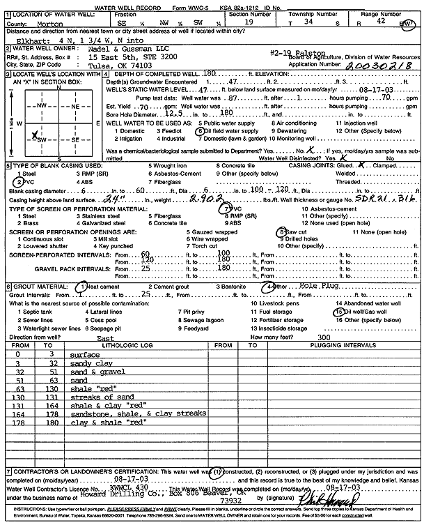
T34S, R42W, Sec. 19 SE NW SW |
Nadel and Gussman LLC | 180 ft. | 47 ft. | 70 gpm. | Oil Field Water Supply | Ralston 2-19 | Constructed | 17-Aug-2003 | Scan |
|
T34S, R42W, Sec. 19 C SW SW |
U.S. Forest Service | 54 ft. | 42 ft. | Domestic | B-1 | Plugged | 13-Oct-1992 | ||
|
T34S, R42W, Sec. 20 SW SW SW |
Ambrosier, Brad | 140 ft. | Domestic, Livestock | Plugged | 23-Apr-2022 |
KOLAR |
|||
|
T34S, R42W, Sec. 20 SW SW SW |
Ambrosier, Brad | 160 ft. | 68 ft. | 25 gpm. | Domestic, Livestock | Constructed | 15-Apr-2022 |
KOLAR |
|
|
T34S, R42W, Sec. 21 SW NW NE |
USDA Forest Service (was EOG Resources, Inc.) | 230 ft. | 70 ft. | 80 gpm. | Domestic, changed from Oil Field Water Supply | CNG 21-1 | Constructed | 12-Apr-2008 | |
|
T34S, R42W, Sec. 23 NW NW NW |
Coen, M.R. | 150 ft. | 88 ft. | 25 gpm. | Domestic | Constructed | 16-Apr-1976 | ||
|
T34S, R42W, Sec. 24 C NW SE |
Oxy USA, Inc. | 280 ft. | 125 ft. | 75 gpm. | Oil Field Water Supply | Brown E 3 | Constructed | 16-Oct-1991 | |
|
T34S, R42W, Sec. 24 C NW SE |
Oxy USA, Inc. | 280 ft. | 125 ft. | Oil Field Water Supply | Brown E 3 | Plugged | 10-Dec-1991 | ||
|
T34S, R42W, Sec. 25 NW SW NW |
Brown, Lyman H. | 431 ft. | 68 ft. | 2000 gpm. | Irrigation | Constructed | 21-Jul-1976 | ||
|
T34S, R42W, Sec. 25 SE NW SW |
Cities Service Co. | 226 ft. | 102 ft. | 75 gpm. | Oil Field Water Supply | Snead A 1 | Constructed | 10-Sep-1986 | |
|
T34S, R42W, Sec. 26 NW NW SE |
Anadarko Petroleum Corp./Virgil Warner | 220 ft. | 95 ft. | 70 gpm. | Oil Field Water Supply | Chandley A 1 | Constructed | 14-Oct-1984 | |
|
T34S, R42W, Sec. 28 SW SW SE |
Hawkins Oil and Gas | 200 ft. | 100 ft. | 24 gpm. | Oil Field Water Supply | Constructed | 20-Nov-1985 | ||
|
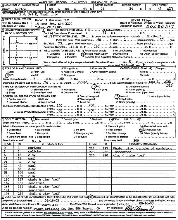
T34S, R42W, Sec. 28 NE NE NE |
Nadel and Gussman LLC | 280 ft. | 78 ft. | 75 gpm. | Oil Field Water Supply | Riley 2-28 | Constructed | 16-Aug-2003 | Scan |
|
T34S, R42W, Sec. 28 C NE |
U.S. Forest Service | 180 ft. | 85 ft. | 45 gpm. | Domestic, Livestock | Constructed | 20-Jun-1978 | ||
|
T34S, R42W, Sec. 32 NE NE NE |
Cimarron National Grassland | 125 ft. | (unstated)/abandoned | Plugged | 21-Oct-1997 | ||||
|
T34S, R42W, Sec. 33 NE SE SE |
Cimarron National Grassland | 265 ft. | 122 ft. | 35 gpm. | Domestic | Constructed | 06-Apr-2005 | ||
|
T34S, R42W, Sec. 33 SW SW SW |
Cimarron National Grassland | 265 ft. | 112 ft. | Domestic | Constructed | 01-Oct-2001 | Scan | ||
|
T34S, R42W, Sec. 33 C SE NE |
Cimarron National Grassland | 54 ft. | 42 ft. | Domestic, Livestock | Plugged | 23-Oct-1996 | |||
|
T34S, R42W, Sec. 33 SW SW SW |
U.S. Forest Service | 203 ft. | 113 ft. | 12 gpm. | Domestic | Constructed | 21-Jun-1996 | ||
|
T34S, R42W, Sec. 34 SE NE SW |
Gabbert and Jones | 200 ft. | 120 ft. | 65 gpm. | Oil Field Water Supply | Central Life A-1 | Constructed | 30-Aug-1986 | |
|
T34S, R42W, Sec. 34 C SW SW |
U.S. Forest Service | 300 ft. | 118 ft. | Domestic, Livestock | A-7 | Plugged | 24-Sep-1992 | ||
|
T34S, R42W, Sec. 35 NW SW NE |
Anadarko Petroleum Corp. | 210 ft. | 110 ft. | 60 gpm. | Oil Field Water Supply | Taloga 503 and 604 | Constructed | 05-Aug-1985 | |
|
T34S, R42W, Sec. 36 C NE NE |
Big A Drilling | 260 ft. | 208 ft. | 100 gpm. | Oil Field Water Supply | Bennett B 5 | Constructed | 19-Jan-1995 | |
|
T34S, R42W, Sec. 36 SW SW SE |
Smith, Howard | 300 ft. | 149 ft. | Domestic | Constructed | 04-May-1998 | |||
|
T34S, R43W, Sec. 1 C SW NW |
Anadarko Petroleum Corp. | 280 ft. | 118 ft. | 50 gpm. | Oil Field Water Supply | Interstate R 1 | Constructed | 23-Nov-1981 | |
|
T34S, R43W, Sec. 1 C SW SW |
U.S. Forest Service | 300 ft. | 94 ft. | Domestic, Livestock | A-5 | Plugged | 25-Sep-1992 | ||
|
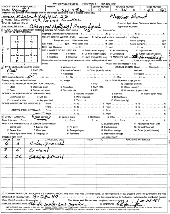
T34S, R43W, Sec. 2 SW SW |
U.S. Forest Service | 26 ft. | Domestic | Well 12 | Plugged | 28-Sep-1999 | Scan | ||
|
T34S, R43W, Sec. 3 NE NE SW |
U.S. Forest Service | 109 ft. | (unstated)/abandoned | Plugged | 09-Oct-1997 | ||||
|
T34S, R43W, Sec. 5 NW SW SW |
Mustang Drilling | 240 ft. | 155 ft. | 50 gpm. | Oil Field Water Supply | Williams 1 | Constructed | 11-Feb-1986 | |
|
T34S, R43W, Sec. 7 SE SE SW |
Cimarron National Grassland | 152 ft. | 150 ft. | (unstated)/abandoned | Plugged | 09-Oct-1997 | |||
|
T34S, R43W, Sec. 7 NE NE SW |
Morton County Grazing Assoc. | 240 ft. | 70 ft. | 25 gpm. | Domestic | Well 2 | Constructed | 26-Aug-1994 | |
|
T34S, R43W, Sec. 8 NE SW SE |
Anadarko Petroleum Co. | 200 ft. | 130 ft. | Monitoring well/observation/piezometer | Plugged | 08-Oct-2013 | |||
| View page: < Prev || 11 || 12 || 13 || 14 || 15 || 16 || 17 || 18 || 19 || 20 || Next > | |||||||||