Select location of well to view details.
Click on column heading to sort.
|
|
|
County: Rawlins Select location of well to view details. Click on column heading to sort. |
|
|
|
| View page: 1 || 2 || 3 || 4 || 5 || 6 || 7 || 8 || 9 || 10 || Next > | |||||||||
| T-R-S | Owner | Well Depth Ascend. Desc. |
Static Water Level Ascend. Desc. |
Est. Yield Ascend. Desc. |
Well Use | Other ID | Action Taken | Completion Date Ascend. Desc. |
Scan? |
|
T2S, R31W, Sec. 10 NE SE NE SE |
Grafel, Rachel | 115 ft. | 75 ft. | 10 gpm. | Domestic, Livestock | Constructed | 20-Sep-2021 |
KOLAR |
|
|
T2S, R31W, Sec. 13 NW SW SW NW |
M and W Farm | 188 ft. | 172 ft. | Domestic, Livestock | Plugged | 02-Jul-2013 | |||
|
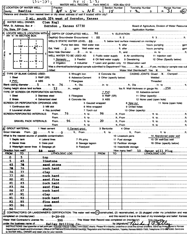
T2S, R31W, Sec. 15 NE SW NE |
Kogl, Clem | 96 ft. | 88 ft. | 2 gpm. | Domestic | Constructed | 28-Sep-1989 | Scan | |
|
T2S, R31W, Sec. 15 NW SW SW NW |
M and W Farm | 200 ft. | 172 ft. | 7 gpm. | Domestic, Livestock | Plugged | 02-Jul-2013 | ||
|
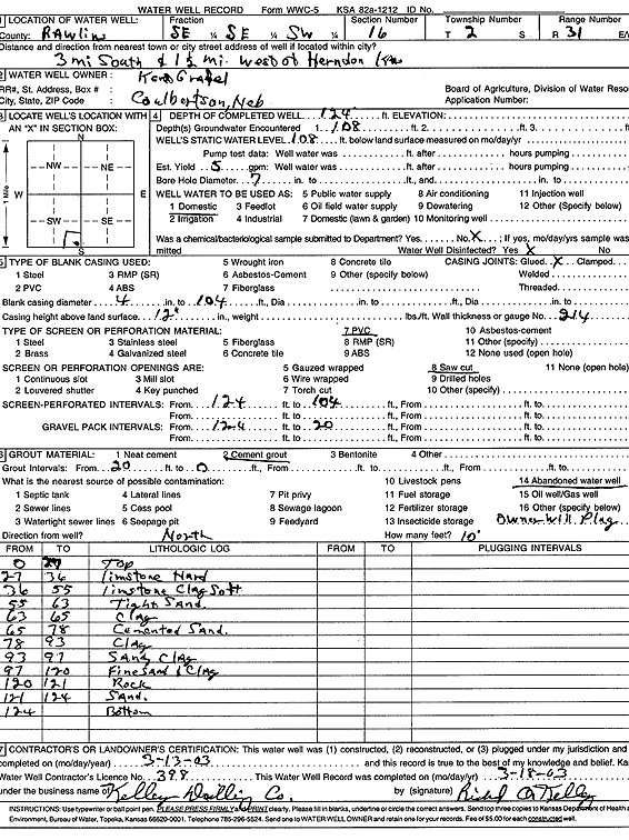
T2S, R31W, Sec. 16 SE SE SW |
Grafel, Kent | 124 ft. | 108 ft. | 5 gpm. | Domestic | Constructed | 13-Mar-2003 | Scan | |
|
T2S, R31W, Sec. 16 NE NE SW NE |
Wolfram, Marlene (was Black Oak Exploration) | 165 ft. | 110 ft. | 30 gpm. | Domestic, changed from Oil Field Water Supply | MW and MS Farms 1-16 | Constructed | 29-Jul-2019 |
KOLAR |
|
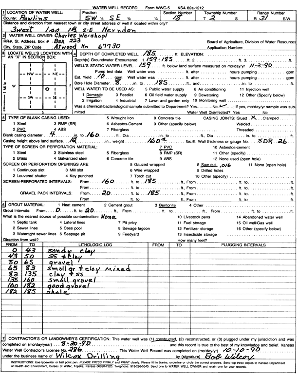
T2S, R31W, Sec. 18 NW NW SE |
Weishopl, Charles | 185 ft. | 159 ft. | 10 gpm. | Domestic | Constructed | 30-Aug-1990 | Scan | |
|
T2S, R31W, Sec. 20 SE NW NW |
Komansm Dick | 140 ft. | 128 ft. | 3 gpm. | Domestic | Constructed | 06-Apr-2000 | Scan | |
|
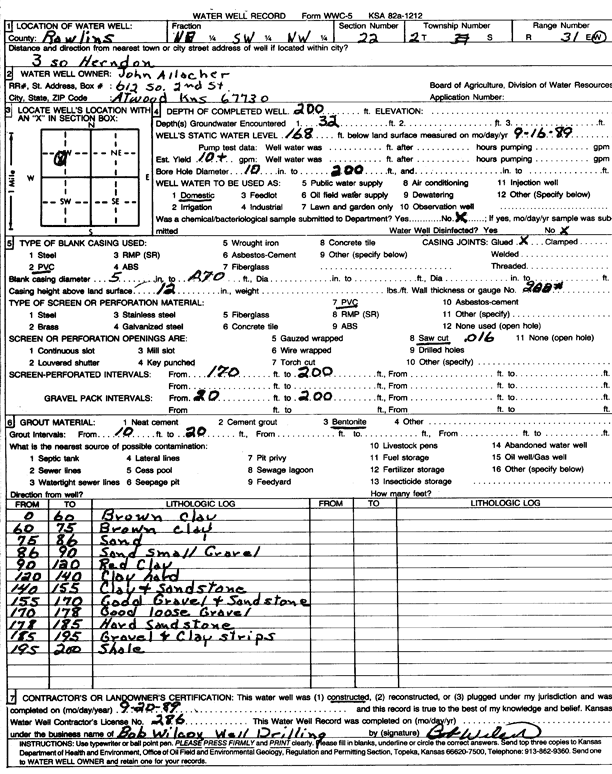
T2S, R31W, Sec. 22 NE SW NW |
Allacher, John | 200 ft. | 168 ft. | 10 gpm. | Domestic | Constructed | 20-Sep-1989 | Scan | |
|
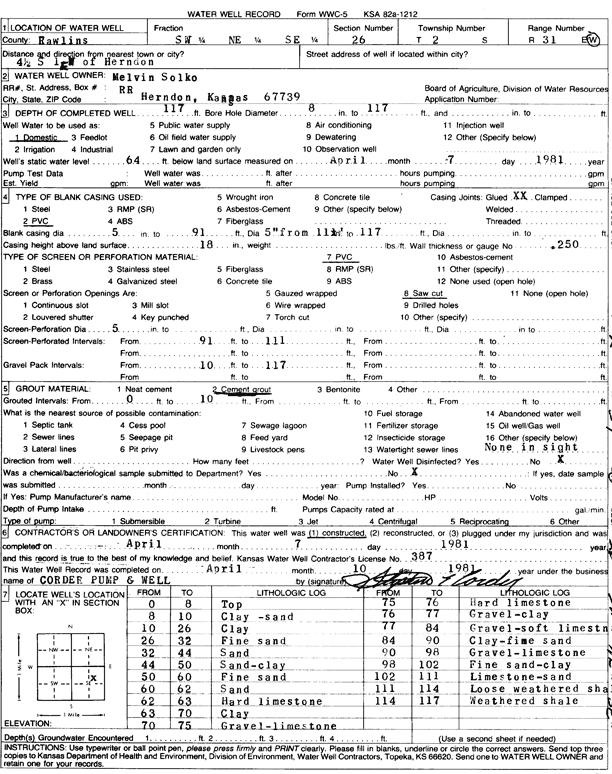
T2S, R31W, Sec. 26 SW NE SE |
Solko, Melvin | 117 ft. | 64 ft. | Domestic | Constructed | 07-Apr-1981 | Scan | ||
|
T2S, R31W, Sec. 33 SE SE SW |
Olson, Mary Lou | 230 ft. | 173 ft. | 20 gpm. | Domestic, Livestock | Constructed | 13-Apr-2023 |
KOLAR |
|
|
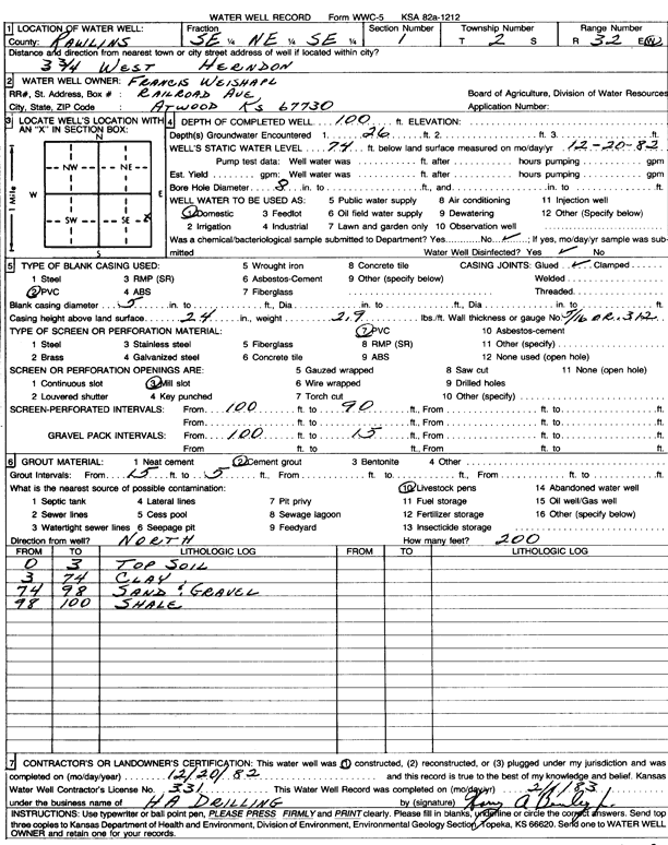
T2S, R32W, Sec. 1 SE NE SE |
Weishapl, Francis | 100 ft. | 74 ft. | Domestic | Constructed | 20-Dec-1982 | Scan | ||
|
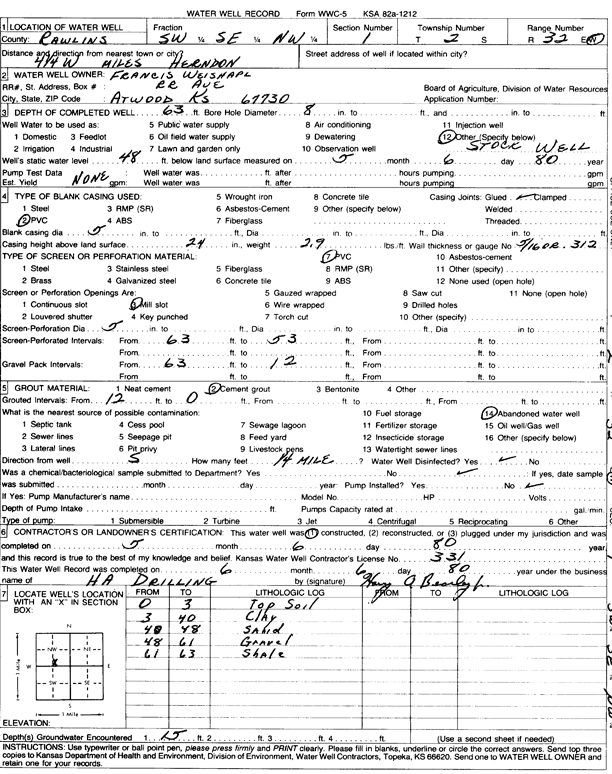
T2S, R32W, Sec. 1 SW SE NW |
Weishapl, Francis | 63 ft. | 48 ft. | Domestic, Livestock | Constructed | 06-May-1980 | Scan | ||
|
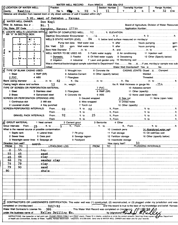
T2S, R32W, Sec. 11 NW NW NE |
Kogl, Don | 92 ft. | 84 ft. | 10 gpm. | Domestic | Constructed | 17-Jul-1992 | Scan | |
|
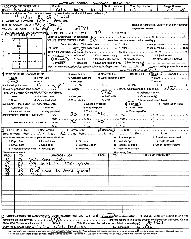
T2S, R32W, Sec. 11 NW NW NW |
Pettera, Patsy | 40 ft. | 26 ft. | Domestic | Constructed | 31-Jul-2003 | Scan | ||
|
T2S, R32W, Sec. 12 MW NE SW |
Kogl, Don | 56 ft. | 48 ft. | Domestic | Constructed | 24-Apr-2009 | |||
|
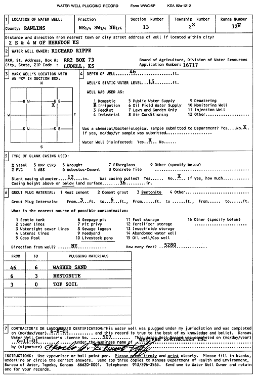
T2S, R32W, Sec. 13 NE SW NE |
Rippe, Richard | 46 ft. | 15 ft. | Irrigation | Plugged | 08-Jun-2001 | Scan | ||
|
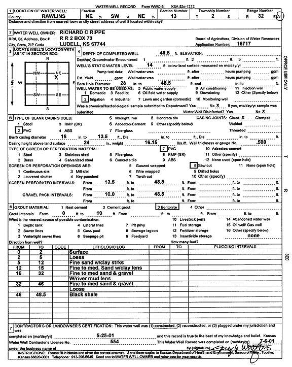
T2S, R32W, Sec. 13 NE SW NE |
Rippe, Richard C. | 48.5 ft. | 14 ft. | Irrigation | Constructed | 25-May-2001 | Scan | ||
|
T2S, R32W, Sec. 14 NE SW SE |
Basgall, Tom | 70 ft. | 25 ft. | 100 gpm. | Irrigation | Constructed | 16-May-2016 | ||
|
T2S, R32W, Sec. 14 NE SW SE |
Basgall, Tom | 40 ft. | 25 ft. | Irrigation | Plugged | 05-Jan-2011 | |||
|
T2S, R32W, Sec. 14 SW NE SE |
Bassgall, Tom | 53 ft. | 12 ft. | 600 gpm. | Irrigation | Constructed | 08-Aug-2023 | KOLAR | |
|
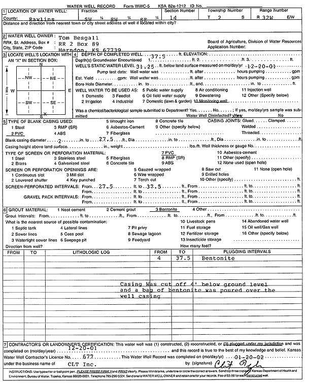
T2S, R32W, Sec. 14 SW SW SE |
Besgall, Tom | 37.5 ft. | 31.25 ft. | Monitoring well/observation/piezometer | Plugged | 20-Dec-2001 | Scan | ||
|
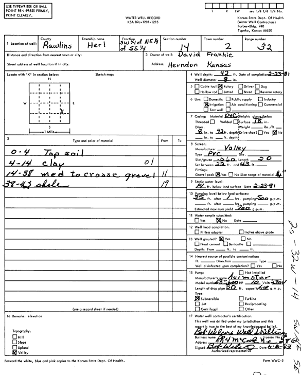
T2S, R32W, Sec. 14 SW NE SE |
Frankie, David | 42 ft. | 14 ft. | 700 gpm. | Irrigation | Constructed | 23-Feb-1981 | Scan | |
|
T2S, R32W, Sec. 14 NE NE SW |
Most, Walter | 140 ft. | 133 ft. | Domestic | Constructed | 17-Apr-1978 | Scan | ||
|
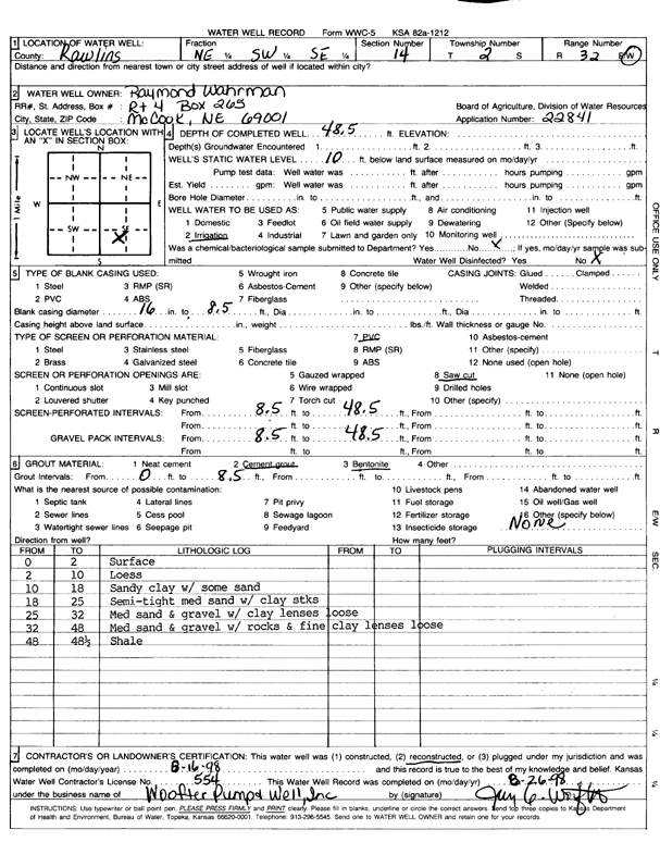
T2S, R32W, Sec. 14 NE SW SE |
Wahrman, Raymond | 48.5 ft. | 10 ft. | Irrigation | Reconstructed | 16-Aug-1998 | Scan | ||
|
T2S, R32W, Sec. 15 SE NW NW |
Pettra, John | 96 ft. | 83 ft. | Domestic | Constructed | 27-Aug-2016 | |||
|
T2S, R32W, Sec. 16 SE SE SE |
Stice, Larry and Janet | 46 ft. | Domestic | Constructed | 30-Oct-2008 | ||||
|
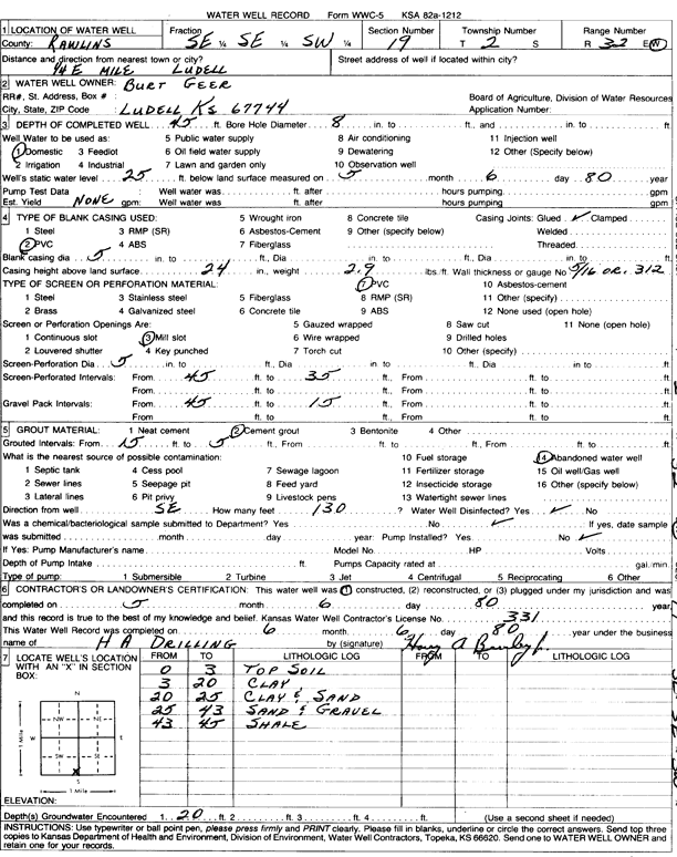
T2S, R32W, Sec. 19 SE SE SW |
Geer, Burt | 45 ft. | 25 ft. | Domestic | Constructed | 06-May-1980 | Scan | ||
|
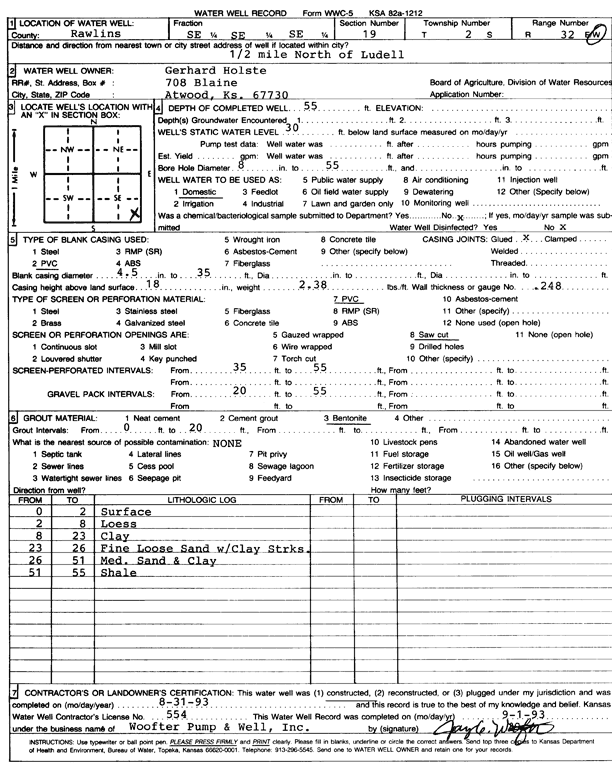
T2S, R32W, Sec. 19 SE SE SE |
Holste, Gerhard | 55 ft. | 30 ft. | Domestic | Constructed | 31-Aug-1993 | Scan | ||
|
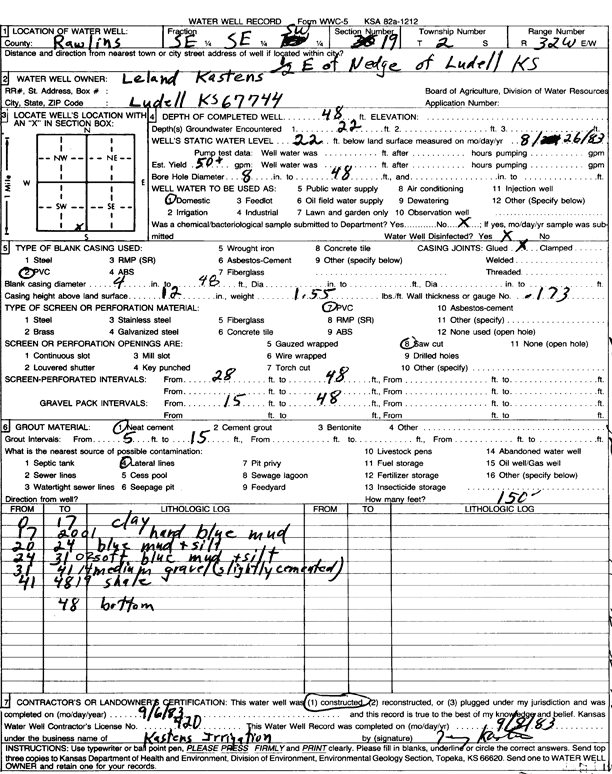
T2S, R32W, Sec. 19 SE SE SW |
Kastens, Leland | 48 ft. | 22 ft. | 50 gpm. | Domestic | Constructed | 06-Sep-1983 | Scan | |
|
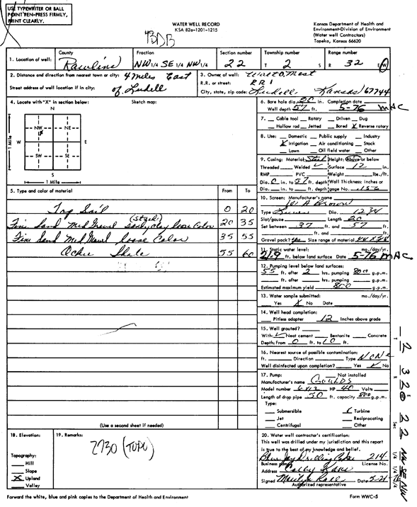
T2S, R32W, Sec. 21 SW SW SW |
Holle, Kevin | 51 ft. | 19 ft. | Irrigation | Constructed | 26-Jul-1999 | |||
|
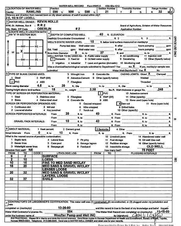
T2S, R32W, Sec. 21 NW NW NW NW |
Holle, Kevin | 100 ft. | 70 ft. | 40 gpm. | Domestic, Livestock | Constructed | 17-Jul-2017 |
KOLAR |
|
|
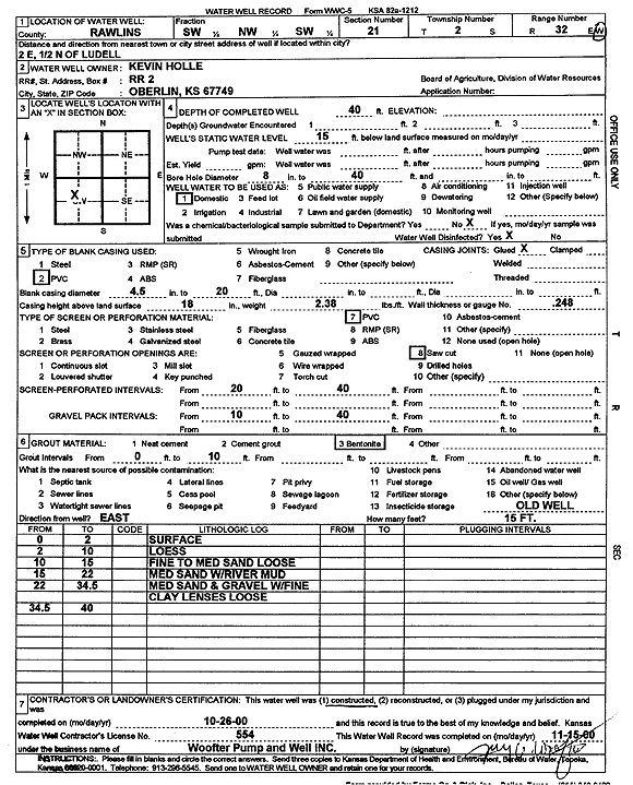
T2S, R32W, Sec. 21 SW NW SW |
Holle, Kevin | 40 ft. | 15 ft. | Domestic | Constructed | 26-Oct-2000 | Scan | ||
|
T2S, R32W, Sec. 21 SW NW SW |
Holle, Kevin | 40 ft. | 15 ft. | Domestic | Constructed | 26-Oct-2000 | Scan | ||
|
T2S, R32W, Sec. 21 NE SE NE |
Hollee, Kevin | 63 ft. | 25 ft. | 500 gpm. | Irrigation | Constructed | 27-Oct-2025 |
KOLAR |
|
|
T2S, R32W, Sec. 21 SW SE NE |
Hollee, Kevin | 63 ft. | 25 ft. | 500 gpm. | Irrigation | Constructed | 27-Oct-2025 |
KOLAR |
|
|
T2S, R32W, Sec. 22 NW SE NW |
Most, Walt | 57 ft. | 21.9 ft. | 800 gpm. | Irrigation | Constructed | 01-May-1976 | Scan | |
|
T2S, R32W, Sec. 22 NW SW SW |
Rippe, Tim | 68 ft. | 49 ft. | 25 gpm. | Domestic | Constructed | 13-Aug-2024 |
KOLAR |
|
|
T2S, R32W, Sec. 22 NW SW SW NE |
Vap, Jeff | 45 ft. | 0 gpm. | Domestic, Livestock | Plugged | 30-Jan-2014 |
KOLAR |
||
|
T2S, R32W, Sec. 22 NW SW SW NE |
Vap, Jeff | 45 ft. | 25 ft. | 35 gpm. | Domestic | Constructed | 16-Jan-2014 |
KOLAR |
|
|
T2S, R32W, Sec. 23 SW NW NW NE |
Ketterl, Vernon | 64 ft. | 35 ft. | 20 gpm. | Domestic, Livestock | Constructed | 19-Mar-2013 | ||
|
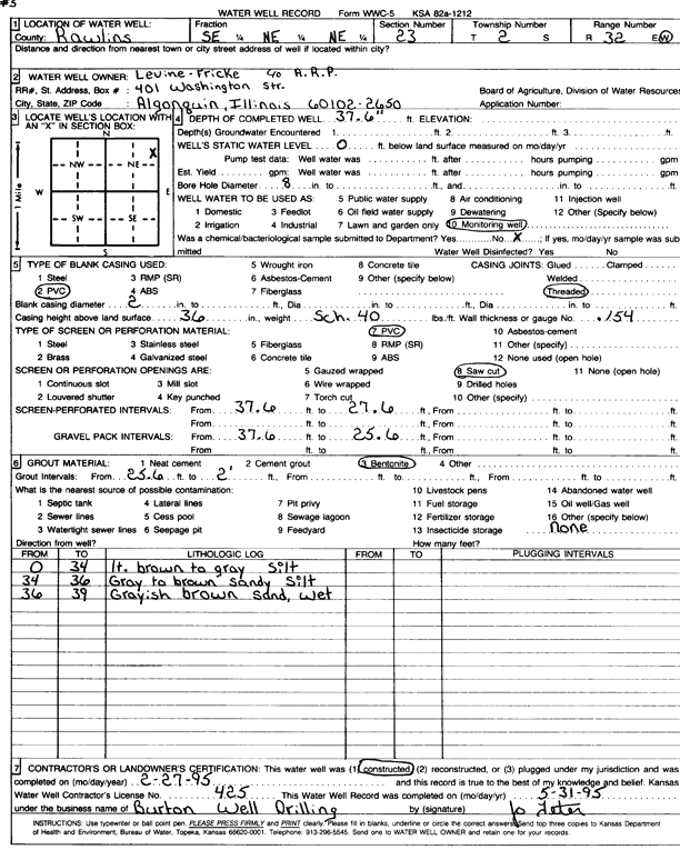
T2S, R32W, Sec. 23 SE NE NE |
Levine-Fricke | 37.6 ft. | Monitoring well/observation/piezometer | Constructed | 27-Feb-1995 | Scan | |||
|
T2S, R32W, Sec. 23 NW |
Martin, Ann or Robert or Henry | 58 ft. | 10 gpm. | Domestic | Constructed | 14-Dec-2007 | |||
|
T2S, R32W, Sec. 23 NW SW NW |
Martin, Henry | 50 ft. | 28 ft. | Domestic, Livestock | Constructed | 08-Dec-2023 |
KOLAR |
||
|
T2S, R32W, Sec. 27 W2 SE SW |
Kastens. Steven | 20 ft. | 2 gpm. | Domestic, Livestock | Constructed | 05-Apr-2021 | |||
|
T2S, R32W, Sec. 28 NW NE SW NW |
Holle, Kevin | 70 ft. | 40 ft. | 20 gpm. | Domestic, Livestock | Constructed | 12-Jun-2012 |
KOLAR |
|
|
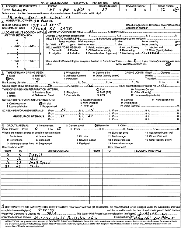
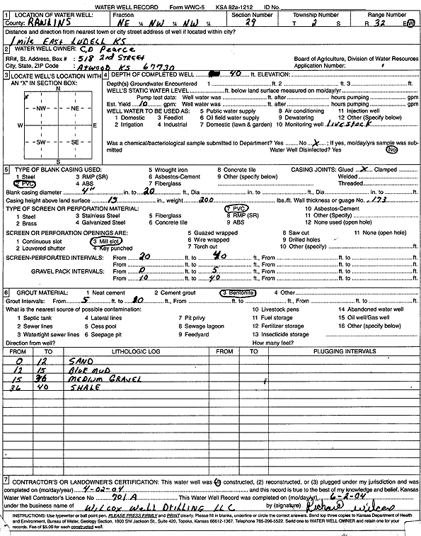
T2S, R32W, Sec. 29 NE NW NW |
Pearce, C.D. | 25 ft. | 10 ft. | Domestic, Livestock | Constructed | 02-Apr-2004 | Scan | ||
|
T2S, R32W, Sec. 29 NE NW NW |
Pearce, C.D. | 40 ft. | 10 gpm. | Domestic, Livestock | Constructed | 02-Apr-2004 | Scan | ||
|
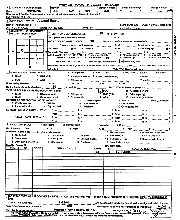
T2S, R32W, Sec. 30 SE SW NW |
Atwood Equity Coop. Exchange | 25 ft. | 19 ft. | Monitoring well/observation/piezometer | MW 3 | Plugged | 21-Feb-2001 | Scan | |
|
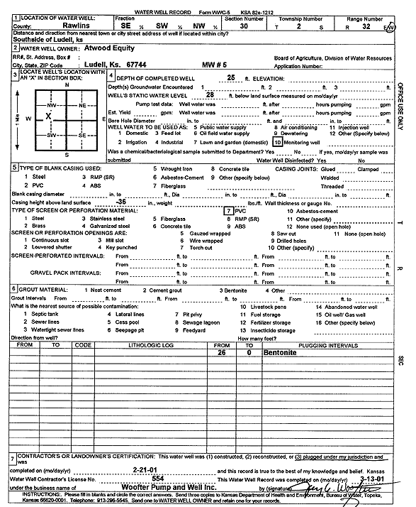
T2S, R32W, Sec. 30 SE SW NW |
Atwood Equity Coop. Exchange | 25 ft. | 28 ft. | Monitoring well/observation/piezometer | MW 5 | Plugged | 21-Feb-2001 | Scan | |
| View page: 1 || 2 || 3 || 4 || 5 || 6 || 7 || 8 || 9 || 10 || Next > | |||||||||