Select location of well to view details.
Click on column heading to sort.
|
|
|
County: Reno Select location of well to view details. Click on column heading to sort. |
|
|
|
| View page: < Prev || 251 || 252 || 253 || 254 || 255 || 256 || 257 || 258 || 259 || 260 || Next > | |||||||||
| T-R-S | Owner | Well Depth Ascend. Desc. |
Static Water Level Ascend. Desc. |
Est. Yield Ascend. Desc. |
Well Use | Other ID | Action Taken | Completion Date Ascend. Desc. |
Scan? |
|
T23S, R8W, Sec. 4 NW NW NE NW |
Shell Oil Corp. | 80 ft. | 20 ft. | Monitoring well/observation/piezometer | Reffner 2308 4 | Constructed | 12-Feb-2013 |
KOLAR |
|
|
T23S, R8W, Sec. 4 NE NW SE NW |
Shell Oil Corp. | 73 ft. | 17 ft. | 250 gpm. | Oil Field Water Supply | Reffner 2308 4 | Constructed | 11-Feb-2013 |
KOLAR |
|
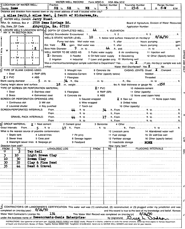
T23S, R8W, Sec. 5 SE SE NE |
Nuest, Jerry | 44 ft. | 10 ft. | Domestic | Constructed | 24-Aug-1990 | Scan | ||
|
T23S, R8W, Sec. 6 NE NE NW |
Stuckey Properties LLC | 99.5 ft. | 32 ft. | 75 gpm. | Domestic, Livestock | Constructed | 21-Mar-2025 |
KOLAR |
|
|
T23S, R8W, Sec. 7 NW NW NW |
Stuckey Properties LLC | 77 ft. | 23 ft. | 15 gpm. | Domestic, Livestock | Constructed | 20-Mar-2025 |
KOLAR |
|
|
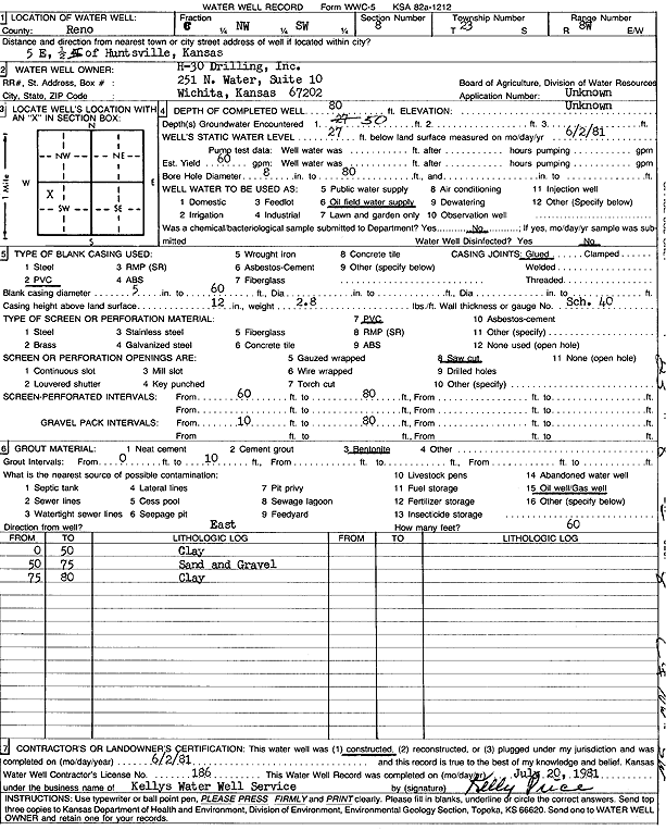
T23S, R8W, Sec. 8 C NW SW |
H-30 Drilling, Inc. | 80 ft. | 27 ft. | 60 gpm. | Oil Field Water Supply | Constructed | 02-Jun-1981 | Scan | |
|
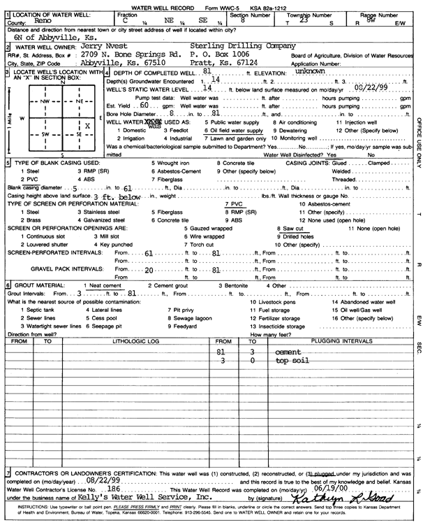
T23S, R8W, Sec. 8 C NE SE |
Nuest, Jerry/Sterling Drilling | 81 ft. | 14 ft. | 60 gpm. | Oil Field Water Supply | Plugged | 22-Aug-1999 | Scan | |
|
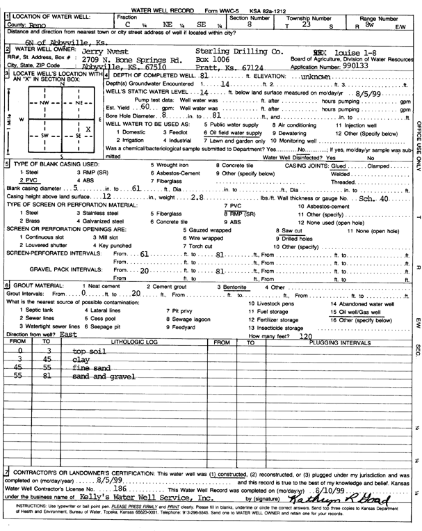
T23S, R8W, Sec. 8 C NE SE |
Nuest, Jerry/Sterling Drilling Co. | 81 ft. | 14 ft. | 60 gpm. | Oil Field Water Supply | Louise 1-8 | Constructed | 05-Aug-1999 | Scan |
|
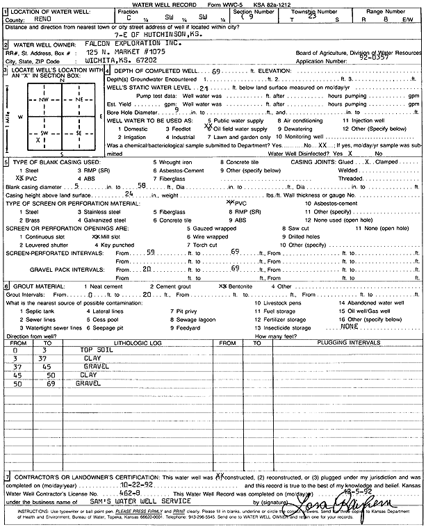
T23S, R8W, Sec. 9 C SW SW |
Falcon Exploration, Inc. | 69 ft. | 21 ft. | Oil Field Water Supply | Constructed | 22-Oct-1992 | Scan | ||
|
T23S, R8W, Sec. 9 C SE NW |
Falcon Exploration/Arlen Nuest | 75 ft. | 14 ft. | Oil Field Water Supply | Constructed | 18-Apr-2006 | |||
|
T23S, R8W, Sec. 9 C SE NW |
Falcon Exploration/Arlen Nuest | 75 ft. | 14 ft. | Oil Field Water Supply | Plugged | 16-Jun-2006 | |||
|
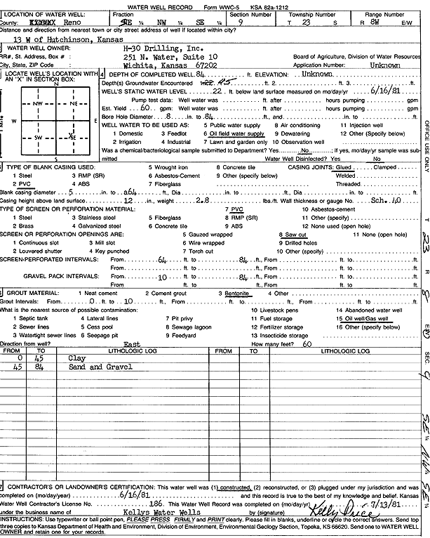
T23S, R8W, Sec. 9 SE NW SE |
H-30 Drilling, Inc. | 84 ft. | 22 ft. | 60 gpm. | Oil Field Water Supply | Constructed | 16-Jun-1981 | Scan | |
|
T23S, R8W, Sec. 9 NE NE SE SE |
Waddle, Bob | 43 ft. | 11 ft. | 50 gpm. | Domestic, Livestock | Constructed | 08-May-2015 |
KOLAR |
|
|
T23S, R8W, Sec. 10 NW SE SE SW |
Hiatt, Nathan | 47 ft. | 12 ft. | 30 gpm. | Domestic | Constructed | 11-Dec-2020 |
KOLAR |
|
|
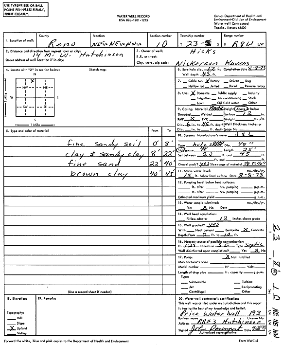
T23S, R8W, Sec. 10 NE NE NW |
Hicks | 45 ft. | 15 ft. | Domestic | Constructed | 08-Aug-1975 | Scan | ||
|
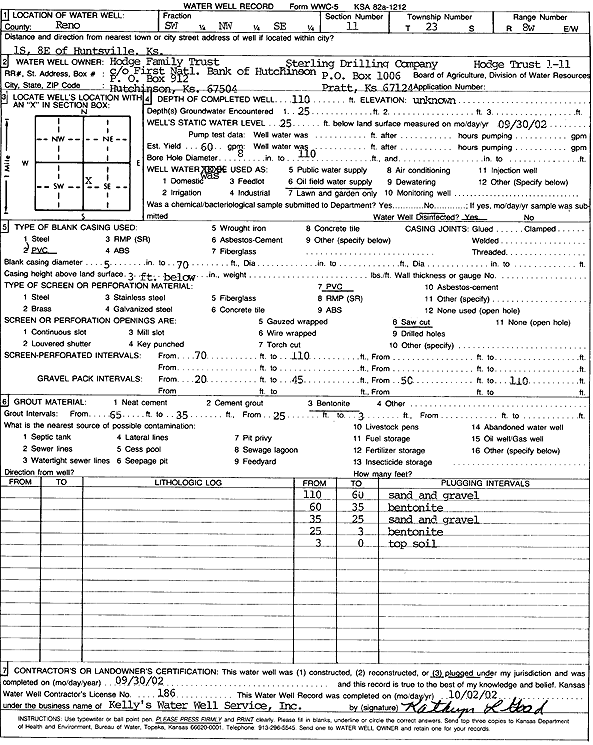
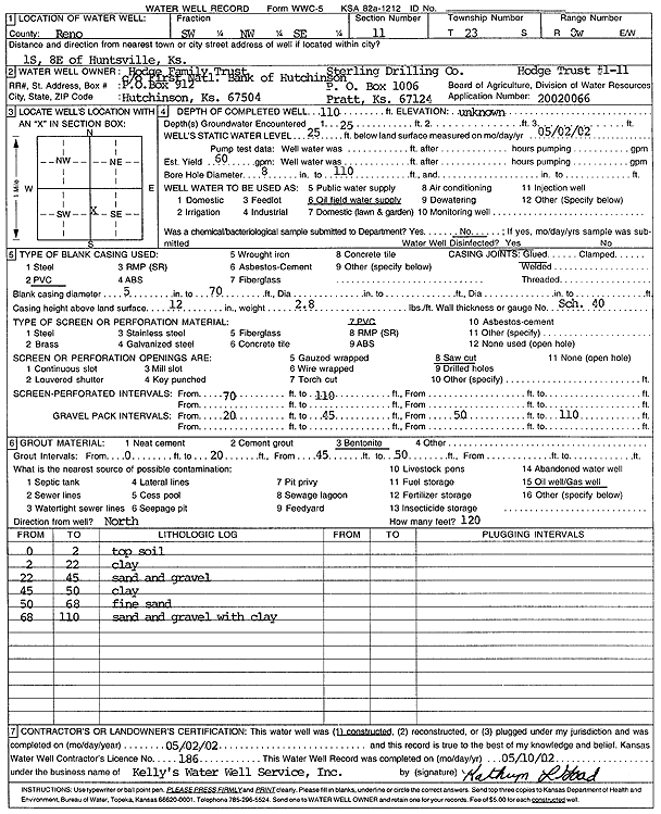
T23S, R8W, Sec. 11 SW NW SE |
Hodge Family Trust/Sterling Drilling | 110 ft. | 25 ft. | 60 gpm. | Oil Field Water Supply | Hodge Trust 1-11 | Plugged | 30-Sep-2002 | Scan |
|
T23S, R8W, Sec. 11 SW NW SE |
Hodge Family Trust/Sterling Drilling Co. | 110 ft. | 25 ft. | 60 gpm. | Oil Field Water Supply | Hodge Trust 1-11 | Constructed | 02-May-2002 | Scan |
|
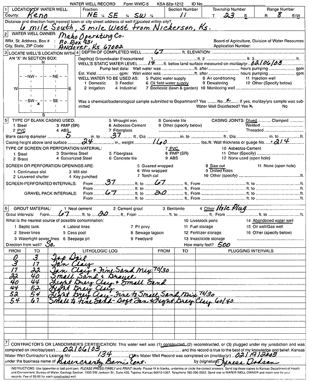
T23S, R8W, Sec. 11 NE SE SW |
Mako Operating Co. | 67 ft. | 14 ft. | Oil Field Water Supply | Constructed | 06-Feb-2003 | Scan | ||
|
T23S, R8W, Sec. 11 C S2 N2 NW |
Mako Operating Co./Charlie Mitzner | 70 ft. | 23 ft. | Oil Field Water Supply | 20060130 | Constructed | 22-Apr-2006 | ||
|
T23S, R8W, Sec. 11 NE NW NW NW |
Mitzner, Donna | 53 ft. | 27 ft. | 75 gpm. | Domestic, Livestock | Constructed | 01-Nov-2012 |
KOLAR |
|
|
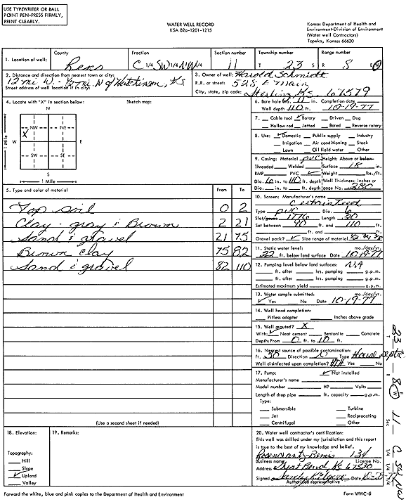
T23S, R8W, Sec. 11 C SW NW |
Schmidt, Harold | 110 ft. | 22 ft. | Domestic | Constructed | 19-Oct-1977 | Scan | ||
|
T23S, R8W, Sec. 11 NE NW NW NW |
Unruh, Troy | 47 ft. | 17 ft. | 75 gpm. | Domestic, Livestock | Constructed | 14-Nov-2019 |
KOLAR |
|
|
T23S, R8W, Sec. 11 NE NW NW NW |
Unruh, Troy | 79 ft. | 17 ft. | 50 gpm. | Domestic, Livestock | Constructed | 07-Oct-2019 |
KOLAR |
|
|
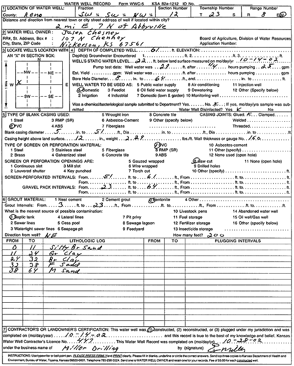
T23S, R8W, Sec. 12 SW SW NW |
Chesney, Jason | 61 ft. | 22 ft. | Domestic | Constructed | 14-Oct-2002 | Scan | ||
|
T23S, R8W, Sec. 12 NW SE SW NW |
Chesney, Jason | 65 ft. | 21 ft. | 150 gpm. | Domestic, Livestock | Constructed | 21-Dec-2016 |
KOLAR |
|
|
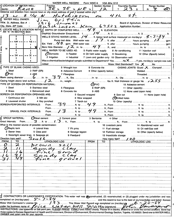
T23S, R8W, Sec. 12 SE SE NE |
Griffin, Jim | 49 ft. | 14 ft. | 40 gpm. | Domestic | Constructed | 07-May-1984 | Scan | |
|
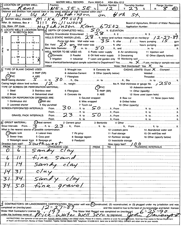
T23S, R8W, Sec. 12 NE SE SE |
Moots, Mike | 50 ft. | 28 ft. | 25 gpm. | Domestic | Constructed | 27-Dec-1989 | Scan | |
|
T23S, R8W, Sec. 12 SE SW NW |
White, Layne | 57 ft. | 28 ft. | Domestic, Livestock | Constructed | 05-Dec-2023 |
KOLAR |
||
|
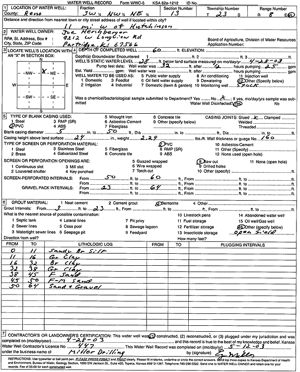
T23S, R8W, Sec. 13 SW NW NE |
Hershberger, Joe | 60 ft. | 28 ft. | Domestic, Livestock | Constructed | 28-Apr-2003 | Scan | ||
|
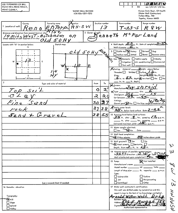
T23S, R8W, Sec. 13 NW NW SW |
McFarland, Kenneth | 55 ft. | 25 ft. | 15 gpm. | Domestic | Constructed | 22-Mar-1976 | Scan | |
|
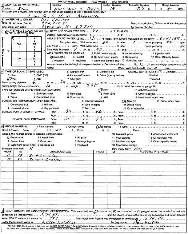
T23S, R8W, Sec. 14 NW NW NW |
Charter, O.L. | 40 ft. | 13 ft. | Domestic | Constructed | 21-Jun-1988 | Scan | ||
|
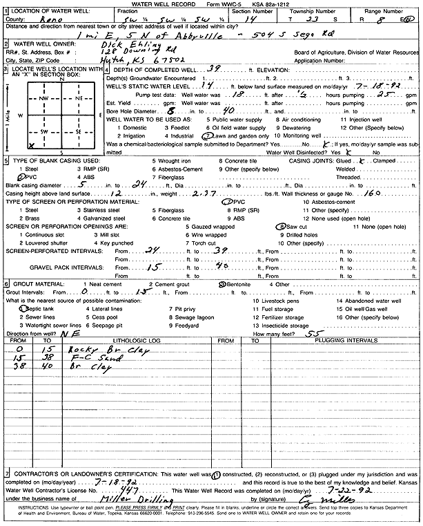
T23S, R8W, Sec. 14 SW SW SW |
Ehling, Dick | 39 ft. | 14 ft. | Domestic, Lawn and Garden | Constructed | 18-Jul-1992 | Scan | ||
|
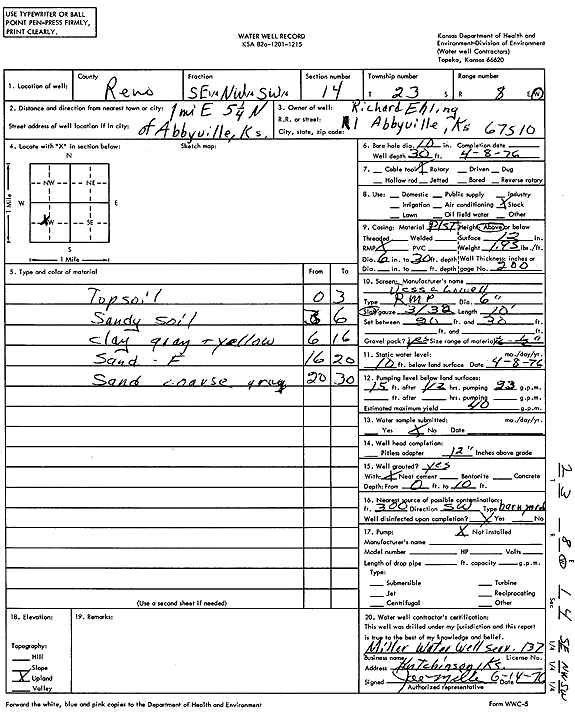
T23S, R8W, Sec. 14 SE NW SW |
Ehling, Richard | 30 ft. | 10 ft. | 40 gpm. | Domestic, Livestock | Constructed | 08-Apr-1976 | Scan | |
|
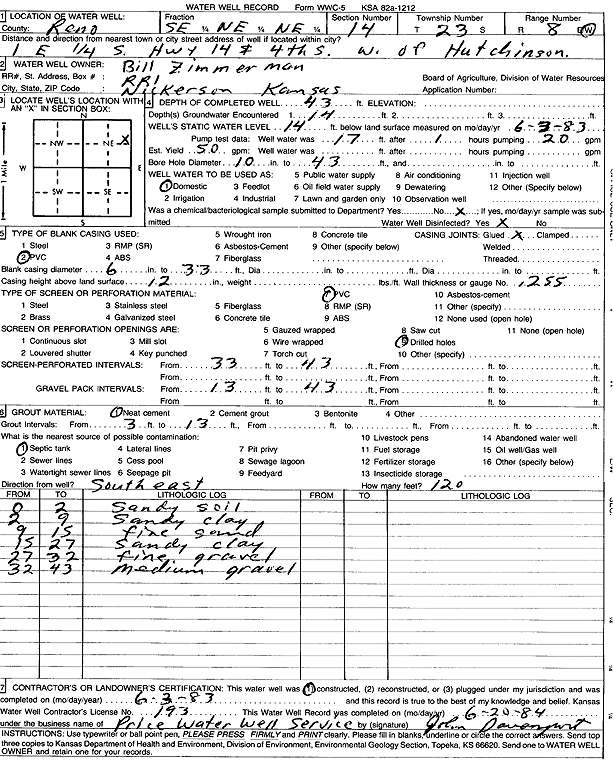
T23S, R8W, Sec. 14 SE NE NE |
Zimmerman, Bill | 43 ft. | 14 ft. | 50 gpm. | Domestic | Constructed | 03-Jun-1983 | Scan | |
|
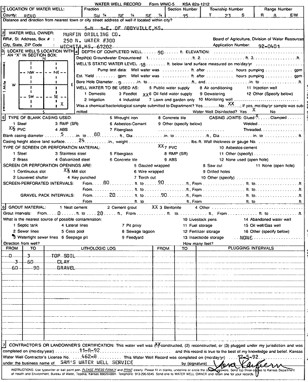
T23S, R8W, Sec. 15 SW SE SE |
Murfin Drilling Co. | 90 ft. | 18 ft. | Oil Field Water Supply | Constructed | 08-Nov-1992 | Scan | ||
|
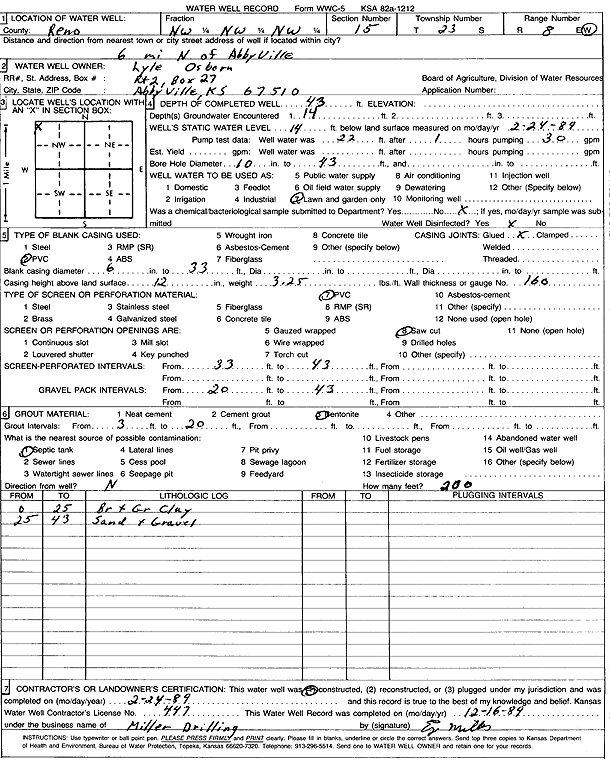
T23S, R8W, Sec. 15 NW NW NW |
Osborn, Lyle | 43 ft. | 14 ft. | Domestic, Lawn and Garden | Constructed | 24-Feb-1989 | Scan | ||
|
T23S, R8W, Sec. 15 NW SE SE |
Schrock, Jay | 75 ft. | 26 ft. | 20 gpm. | Domestic, Livestock | Constructed | 31-Mar-2025 |
KOLAR |
|
|
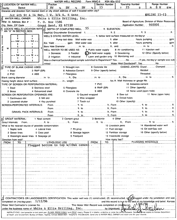
T23S, R8W, Sec. 15 NW SW SW |
White and Ellis Drilling, Inc. | 55 ft. | Oil Field Water Supply | Ehling 15-13 | Plugged | 12-Jan-1996 | Scan | ||
|
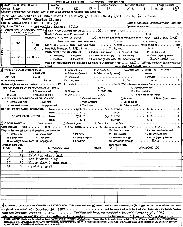
T23S, R8W, Sec. 16 SW SE NE |
Mitzner, Charles | 60 ft. | 40 ft. | Domestic | Constructed | 28-Oct-1987 | Scan | ||
|
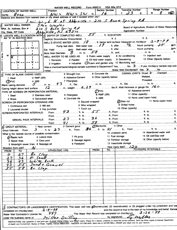
T23S, R8W, Sec. 16 NW NW SW |
Wagler, Stan | 55 ft. | 18 ft. | Domestic, Lawn and Garden | Constructed | 09-Feb-1999 | Scan | ||
|
T23S, R8W, Sec. 16 NW NE NW |
Welker, Jacob | 57 ft. | 36 ft. | 50 gpm. | Domestic, Livestock | Constructed | 02-Jun-2023 | KOLAR | |
|
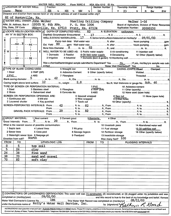
T23S, R8W, Sec. 16 SE NE NW |
Welker, John/Sterling Drilling | 82 ft. | 17 ft. | 80 gpm. | Domestic, Lawn and Garden | Welker 1-16 | Constructed | 01-Sep-2000 | Scan |
|
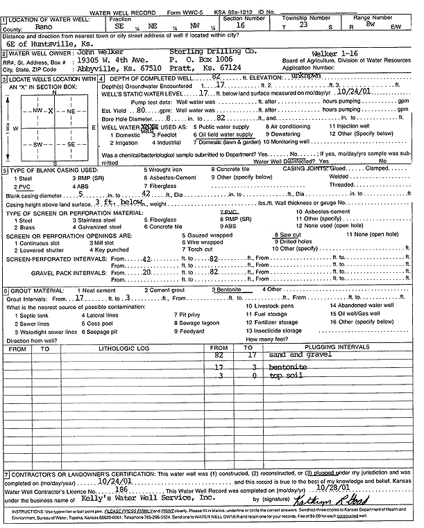
T23S, R8W, Sec. 16 SE NE NW |
Welker, John/Sterling Drilling Co. | 82 ft. | 17 ft. | 80 gpm. | Oil Field Water Supply | Welker 1-16 | Plugged | 24-Oct-2001 | Scan |
|
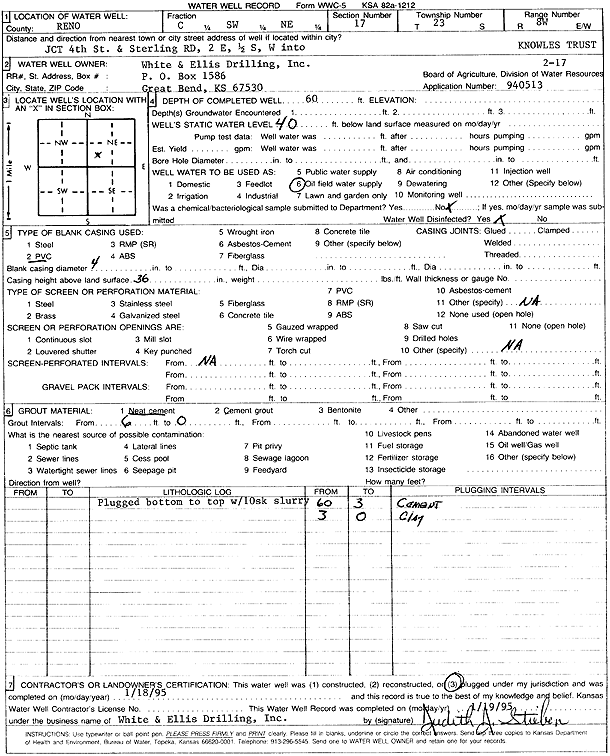
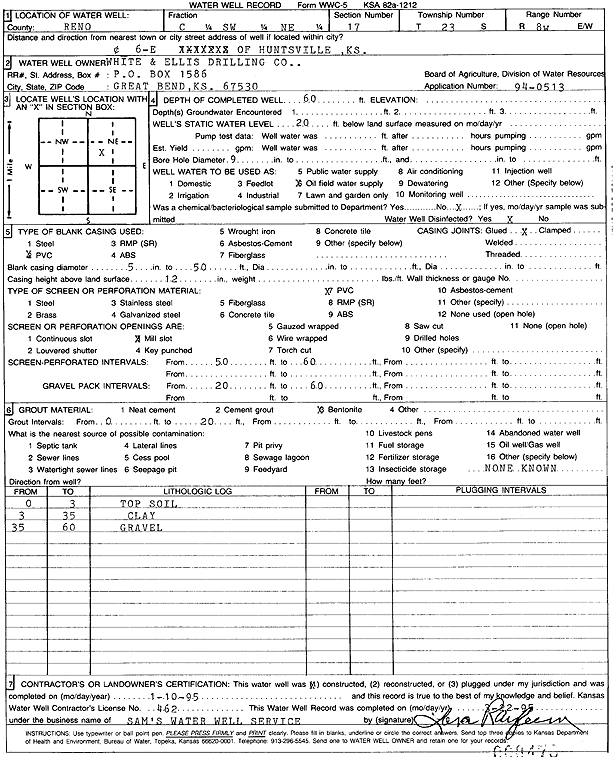
T23S, R8W, Sec. 17 C SW NE |
White and Ellis Drilling | 60 ft. | 40 ft. | Oil Field Water Supply | Knowles Trust 2-17 | Plugged | 18-Jan-1995 | Scan | |
|
T23S, R8W, Sec. 17 C SW NE |
White and Ellis Drilling, Co. | 60 ft. | 20 ft. | Oil Field Water Supply | Constructed | 01-Oct-1995 | Scan | ||
|
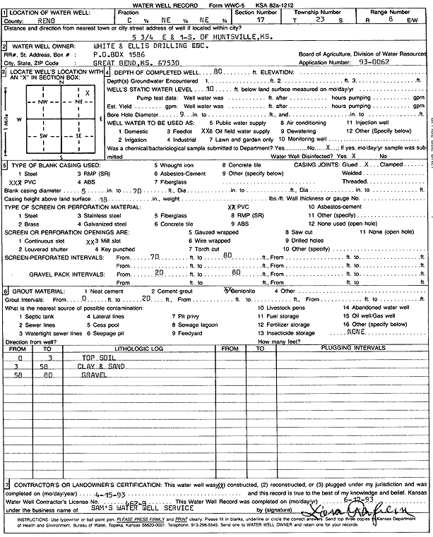
T23S, R8W, Sec. 17 C NE NE |
White and Ellis Drilling, Inc. | 80 ft. | 10 ft. | Oil Field Water Supply | Constructed | 15-Apr-1993 | Scan | ||
|
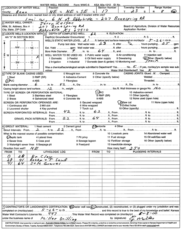
T23S, R8W, Sec. 17 NE NE SE |
Zelfer, Jerry | 62 ft. | 21 ft. | Domestic, Livestock | Constructed | 26-May-2000 | Scan | ||
|
T23S, R8W, Sec. 17 SE NE SE |
Zelfer, Jerry | 62 ft. | 20 ft. | Domestic, Livestock | Constructed | 31-Aug-1998 | |||
|
T23S, R8W, Sec. 18 NW NW SE |
New Gulf Operating | 75 ft. | 12 ft. | Oil Field Water Supply | Plugged | 12-Jan-2012 | |||
|
T23S, R8W, Sec. 18 NW NW SE |
New Gulf Operating | 75 ft. | 12 ft. | Oil Field Water Supply | Constructed | 20-Jun-2011 | |||
| View page: < Prev || 251 || 252 || 253 || 254 || 255 || 256 || 257 || 258 || 259 || 260 || Next > | |||||||||