Select location of well to view details.
Click on column heading to sort.
|
|
|
County: Scott Select location of well to view details. Click on column heading to sort. |
|
|
|
| View page: < Prev || 11 || 12 || 13 || 14 || 15 || 16 || 17 || 18 || 19 || 20 || Next > | |||||||||
| T-R-S | Owner | Well Depth Ascend. Desc. |
Static Water Level Ascend. Desc. |
Est. Yield Ascend. Desc. |
Well Use | Other ID | Action Taken | Completion Date Ascend. Desc. |
Scan? |
|
T18S, R32W, Sec. 20 NW SW NW |
Scott City Municipal Airport | 119.35 ft. | 118.2 ft. | Monitoring well/observation/piezometer | MW 6 | Plugged | 12-Aug-2004 | ||
|
T18S, R32W, Sec. 20 NW NW SE |
Vulgamore, Larry | 69 ft. | Irrigation | Plugged | 02-Nov-1992 | ||||
|
T18S, R32W, Sec. 21 NW SE SW |
Kirk, Thomas M | 132 ft. | 104 ft. | Irrigation | Plugged | 30-Mar-1992 | |||
|
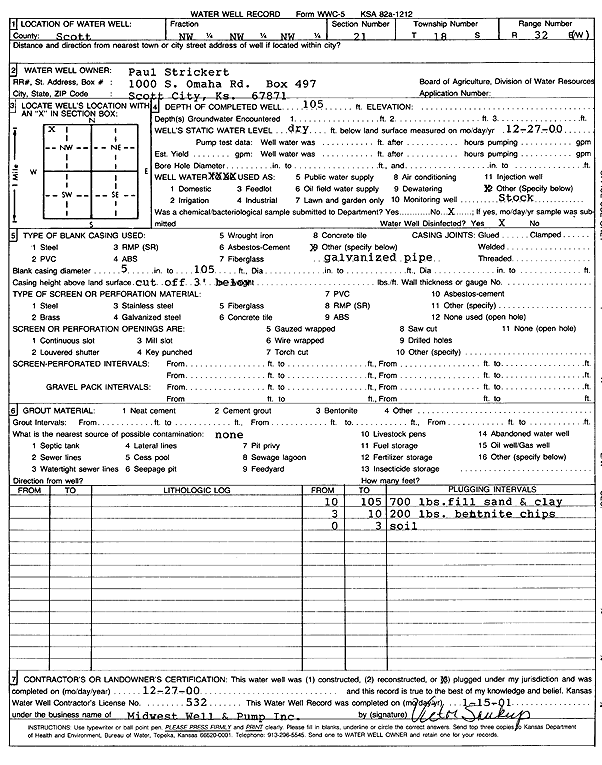
T18S, R32W, Sec. 21 NW NW NW |
Strickert, Paul | 105 ft. | Domestic, Livestock | Plugged | 27-Dec-2000 | Scan | |||
|
T18S, R32W, Sec. 24 SE SE SE |
Romer, Rick | 260 ft. | Heat Pump (Closed Loop/Disposal), Geothermal | Constructed | 12-Aug-2009 | ||||
|
T18S, R32W, Sec. 27 NW NW NW |
Strickert, Paul | 94 ft. | Domestic | Plugged | 04-Feb-1998 | ||||
|
T18S, R32W, Sec. 27 NW NW NW |
Strickert, Paul | 97 ft. | Domestic | Plugged | 04-Feb-1998 | ||||
|
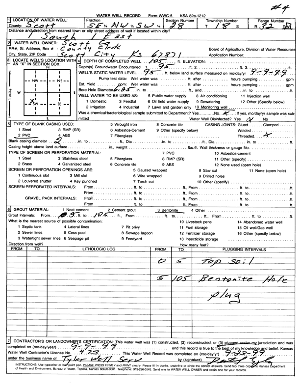
T18S, R32W, Sec. 28 SE NW SW |
Scott County | 105 ft. | 95 ft. | Monitoring well/observation/piezometer | 4 | Plugged | 09-Sep-1999 | Scan | |
|
T18S, R32W, Sec. 28 SW NE SW |
Scott County | 105 ft. | 96 ft. | Monitoring well/observation/piezometer | Constructed | 09-Sep-1999 | |||
|
T18S, R32W, Sec. 28 SE NW SW |
Scott County | 105 ft. | 92 ft. | Monitoring well/observation/piezometer | Constructed | 21-Oct-1996 | |||
|
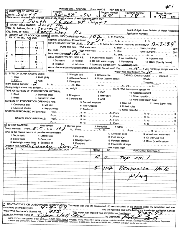
T18S, R32W, Sec. 28 SW SE SW |
Scott County | 102 ft. | 75 ft. | Monitoring well/observation/piezometer | MW 1 | Plugged | 09-Sep-1999 | Scan | |
|
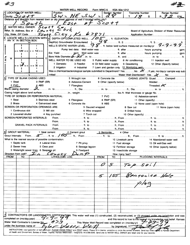
T18S, R32W, Sec. 28 SW NE SW |
Scott County | 105 ft. | 98 ft. | Monitoring well/observation/piezometer | 3 | Plugged | 09-Sep-1999 | Scan | |
|
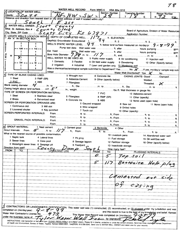
T18S, R32W, Sec. 28 NE NW SW |
Scott County | 117 ft. | 94 ft. | Monitoring well/observation/piezometer | T 8 | Plugged | 08-Sep-1999 | Scan | |
|
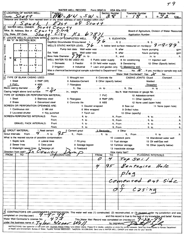
T18S, R32W, Sec. 28 NW NW SW |
Scott County | 95 ft. | 76 ft. | Monitoring well/observation/piezometer | T 9 | Plugged | 09-Sep-1999 | Scan | |
|
T18S, R32W, Sec. 28 SE SE SW |
Scott County Landfill | 97 ft. | 88 ft. | 1 gpm. | Monitoring well/observation/piezometer | Constructed | 09-Dec-1993 | ||
|
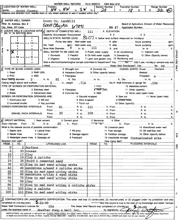
T18S, R32W, Sec. 28 NW NW SW |
Scott County Landfill | 111 ft. | 81.07 ft. | Monitoring well/observation/piezometer | MW 7 | Constructed | 22-May-1999 | Scan | |
|
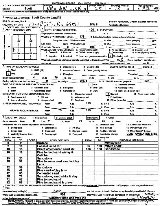
T18S, R32W, Sec. 28 NW NW SW |
Scott County Landfill | 106 ft. | 84 ft. | Monitoring well/observation/piezometer | MW 8 | Constructed | 02-Jul-2001 | Scan | |
|
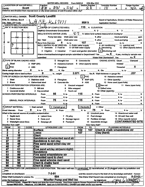
T18S, R32W, Sec. 28 NW NW SW |
Scott County Landfill | 115 ft. | 87 ft. | Monitoring well/observation/piezometer | MW 9 | Constructed | 02-Jul-2001 | Scan | |
|
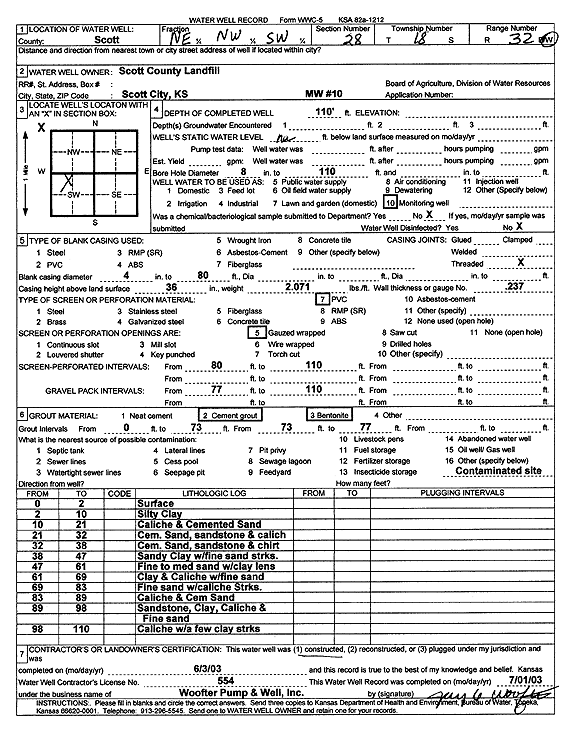
T18S, R32W, Sec. 28 NE NW SW |
Scott County Landfill | 110 ft. | Monitoring well/observation/piezometer | MW 10 | Constructed | 03-Jun-2003 | Scan | ||
|
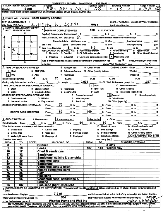
T18S, R32W, Sec. 28 NW NW SW |
Scott County Landfill | 100 ft. | 81 ft. | Monitoring well/observation/piezometer | MW 1 | Constructed | 02-Jul-2001 | Scan | |
|
T18S, R32W, Sec. 28 SW SE SW |
Scott County Landfill | 102 ft. | 75 ft. | 10 gpm. | Monitoring well/observation/piezometer | Constructed | 09-Dec-1993 | ||
|
T18S, R32W, Sec. 28 NW SE SW |
Scott County Landfill | 112 ft. | 85 ft. | Monitoring well/observation/piezometer | 5 | Constructed | 22-Sep-1997 | ||
|
T18S, R32W, Sec. 28 NW SE SW |
Scott County Landfill | 110 ft. | 85 ft. | Monitoring well/observation/piezometer | 6 | Constructed | 22-Sep-1997 | ||
|
T18S, R32W, Sec. 28 NW SE SW |
Scott County Landfill | 112 ft. | Monitoring well/observation/piezometer | 5 | Plugged | 19-Mar-2012 | |||
|
T18S, R32W, Sec. 28 NE SE SW |
Scott County Landfill | 102 ft. | Monitoring well/observation/piezometer | MW 2 | Plugged | 13-Oct-2025 |
KOLAR |
||
|
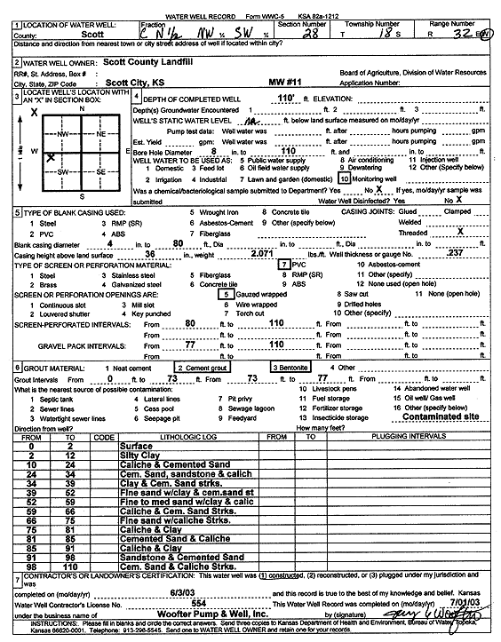
T18S, R32W, Sec. 28 C N2 NW SW |
Scott County Landfill | 110 ft. | Monitoring well/observation/piezometer | MW 11 | Constructed | 03-Jun-2003 | Scan | ||
|
T18S, R32W, Sec. 29 NW NE NW |
City of Scott City | 105 ft. | Irrigation | Plugged | 28-Apr-1988 | ||||
|
T18S, R32W, Sec. 29 NW NW NW |
Vulgamore Land and Cattle | 207 ft. | 124 ft. | Irrigation | Constructed | 01-Aug-2025 |
KOLAR |
||
|
T18S, R32W, Sec. 29 NW NW NW |
Vulgamore, Brian | 93.23 ft. | Irrigation | Plugged | 14-Jan-2026 |
KOLAR |
|||
|
T18S, R32W, Sec. 30 NW NW NE |
Hoeme, Norma Dee | 230 ft. | 111 ft. | 1200 gpm. | Irrigation | Constructed | 09-Feb-1995 | ||
|
T18S, R32W, Sec. 30 SW SW NW |
Hoeme, Stacy | 216 ft. | 108 ft. | 60 gpm. | Domestic | Constructed | 02-Apr-2010 | ||
|
T18S, R32W, Sec. 30 NW SE NE |
Kimball, Mike | 229 ft. | 1200 gpm. | Irrigation | Reconstructed | 05-Jun-1988 | |||
|
T18S, R32W, Sec. 30 NW NE NW |
Mitchell, Lewis | 232 ft. | 140 ft. | 900 gpm. | Irrigation | Constructed | 30-Jul-1992 | ||
|
T18S, R32W, Sec. 30 NW NE NW |
Mitchell, Lewis | 217 ft. | 140 ft. | Irrigation | Plugged | 30-Jul-1992 | |||
|
T18S, R32W, Sec. 31 NE SW SW |
Beach Farms | 163 ft. | 43 ft. | 650 gpm. | Irrigation | Constructed | 20-Jun-1975 | ||
|
T18S, R32W, Sec. 32 SW SW SW |
Doornbos, Jerald | 146 ft. | 44 ft. | 760 gpm. | Irrigation | Constructed | 13-Jul-1976 | ||
|
T18S, R32W, Sec. 32 NW NW SW |
Kimball Cattle Co | 140 ft. | Irrigation | Plugged | 22-Jul-1991 | ||||
|
T18S, R32W, Sec. 32 NW NW SW |
Kimball Cattle Co | 203 ft. | 90 ft. | 600 gpm. | Irrigation | Constructed | 16-Jul-1991 | ||
|
T18S, R32W, Sec. 33 NW SE SE |
Norman, Jan | 99 ft. | 63 ft. | Domestic, Livestock | Constructed | 12-Jun-2001 | |||
|
T18S, R32W, Sec. 34 SW SW SW |
Lebeau, Jonathan and Carrie | 110 ft. | 65 ft. | 1 gpm. | Domestic | Constructed | 28-Mar-2024 |
KOLAR |
|
|
T18S, R32W, Sec. 34 SW SW SW |
Pennell, Roy | 110 ft. | 54 ft. | Domestic | Constructed | 27-Jul-1983 | |||
|
T18S, R32W, Sec. 36 NW NW SW |
McCurdy, Robert | 111 ft. | 67 ft. | 12 gpm. | Domestic | Constructed | 14-Jul-1994 | ||
|
T18S, R33W, Sec. 1 NE NE NE |
Kansas Geological Survey | 227 ft. | 134.74 ft. | Monitoring well/observation/piezometer | site 2 OBGMD 1 | Constructed | 10-Jul-2007 | ||
|
T18S, R33W, Sec. 1 SW SW SW |
Sharp, Floy M. | 220 ft. | 107 ft. | 75 gpm. | Oil Field Water Supply | Melson 1-1 | Constructed | 07-Jun-1985 | |
|
T18S, R33W, Sec. 1 SW SW SW |
Simpson, B. J. | 212 ft. | 119 ft. | Oil Field Water Supply | Plugged | 05-Aug-1987 | |||
|
T18S, R33W, Sec. 2 SE SE NW |
Bar 5 Farms | 205 ft. | 124 ft. | Domestic | Constructed | 16-Feb-1988 | |||
|
T18S, R33W, Sec. 2 NE NE SW |
Sharp, Floy M | 220 ft. | 140 ft. | 75 gpm. | Oil Field Water Supply | Carolyn 1-2 | Constructed | 06-Sep-1985 | |
|
T18S, R33W, Sec. 2 NW NE SW |
Simpson, B. J. | 214 ft. | 125 ft. | Oil Field Water Supply | Plugged | 06-Aug-1987 | |||
|
T18S, R33W, Sec. 3 NE NE NW |
Berry, Charles | 205 ft. | 143 ft. | 29 gpm. | Domestic | Constructed | 28-May-2008 | ||
|
T18S, R33W, Sec. 3 NE NE NW |
Berry, Charles | 200 ft. | 145 ft. | Heat Pump (Closed Loop/Disposal), Geothermal | Constructed | 21-Feb-2011 | |||
| View page: < Prev || 11 || 12 || 13 || 14 || 15 || 16 || 17 || 18 || 19 || 20 || Next > | |||||||||