Select location of well to view details.
Click on column heading to sort.
|
|
|
County: Stanton Select location of well to view details. Click on column heading to sort. |
|
|
|
| View page: 1 || 2 || 3 || 4 || 5 || 6 || 7 || 8 || 9 || 10 || Next > | |||||||||
| T-R-S | Owner | Well Depth Ascend. Desc. |
Static Water Level Ascend. Desc. |
Est. Yield Ascend. Desc. |
Well Use | Other ID | Action Taken | Completion Date Ascend. Desc. |
Scan? |
|
T28S, R41W, Sec. 31 SE SW NW |
McKinney, Marlin | 500 ft. | 195 ft. | Irrigation | Constructed | 23-Dec-1998 | Scan | ||
|
T28S, R41W, Sec. 31 NW NW NW |
Wartman, Greg | 356 ft. | 210 ft. | 25 gpm. | Domestic | Plugged | 24-Aug-2004 | ||
|
T28S, R41W, Sec. 32 SW NW SW |
Lane, Galen | 345 ft. | 206 ft. | 45 gpm. | Domestic | Constructed | 25-Jul-2001 | Scan | |
|
T28S, R41W, Sec. 32 NW NW SE |
Murfin Drilling Co. | 300 ft. | 190 ft. | 70 gpm. | Oil Field Water Supply | Lane 32-1 | Constructed | 30-Jul-1990 | |
|
T28S, R41W, Sec. 34 NE NE SE |
Taff, Steve | 525 ft. | 336 ft. | 30 gpm. | Domestic | Constructed | 07-May-2004 | Scan | |
|
T28S, R41W, Sec. 35 SE SE SE |
Garcia, Porfirio | 495 ft. | 320 ft. | Domestic | Constructed | 07-Jun-2005 | |||
|
T28S, R41W, Sec. 35 C NE NE |
Harris Oil and Gas | 445 ft. | 310 ft. | 90 gpm. | Oil Field Water Supply | Raney 1-35 | Constructed | 29-Aug-1996 | |
|
T28S, R41W, Sec. 35 SE SW NE |
Reese, Evelyn | 631 ft. | 319 ft. | 1200 gpm. | Irrigation | Constructed | 23-Dec-1992 | ||
|
T28S, R41W, Sec. 35 NE NE SW |
Reese, Evelyn | 368 ft. | 330 ft. | Irrigation | Plugged | 26-Aug-1993 | |||
|
T28S, R41W, Sec. 36 NE NW NE |
City of Johnson City | 635 ft. | 332 ft. | 1200 gpm. | Public Water Supply | Constructed | 02-Sep-1994 | ||
|
T28S, R41W, Sec. 36 SE SW NW |
City of Johnson City | 600 ft. | 350 ft. | 600 gpm. | Public Water Supply | Constructed | 11-Jul-1995 | ||
|
T28S, R41W, Sec. 36 SW SW NW |
City of Johnson City | 500 ft. | 255 ft. | 1500 gpm. | Public Water Supply | Constructed | 16-Apr-1979 | ||
|
T28S, R41W, Sec. 36 SE SW NW |
City of Johnson City | 580 ft. | 320 ft. | Domestic | Plugged | 08-Feb-1996 | |||
|
T28S, R41W, Sec. 36 NE NE SE |
City of Johnson City | 641 ft. | 348 ft. | Public Water Supply | Constructed | 22-Aug-2002 | Scan | ||
|
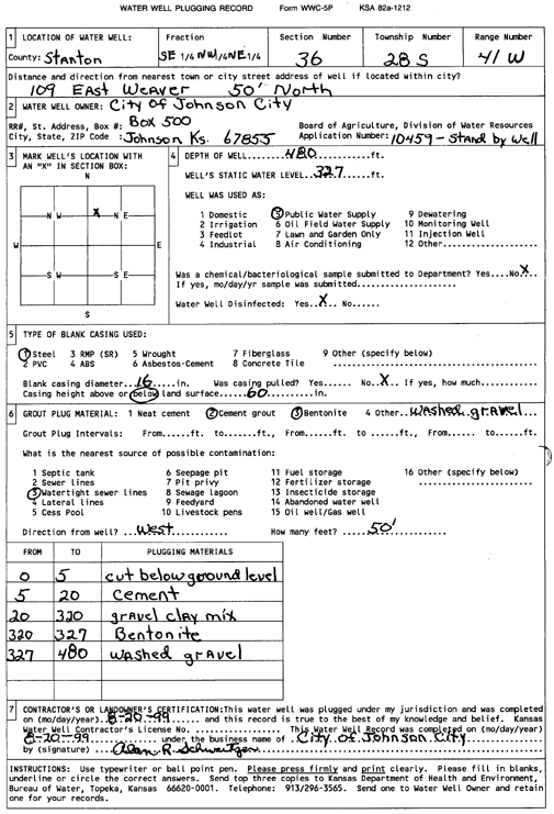
T28S, R41W, Sec. 36 SE NW NE |
City of Johnson City | 480 ft. | 327 ft. | Public Water Supply | Plugged | 20-Aug-1999 | Scan | ||
|
T28S, R41W, Sec. 36 NE NE NE |
Johnson Coop Grain Co. | 375 ft. | Monitoring well/observation/piezometer | MW 1 | Plugged | 10-Jan-2012 | |||
|
T28S, R41W, Sec. 36 NE NE NE |
Johnson Coop Grain Co. | 350 ft. | Monitoring well/observation/piezometer | MW 1 | Constructed | 16-Jun-2010 | |||
|
T28S, R41W, Sec. 36 SW NW SW NE |
Smith, John | 540 ft. | 245 ft. | 20 gpm. | Domestic, Lawn and Garden | Constructed | 15-Oct-2013 |
KOLAR |
|
|
T28S, R41W, Sec. 36 SE NW NE |
Taylor Food Mart | 350 ft. | Monitoring well/observation/piezometer | MW 1 | Plugged | 18-Nov-1999 | Scan | ||
|
T28S, R41W, Sec. 36 SE NW NE |
Taylor Food Mart | 353 ft. | Monitoring well/observation/piezometer | MW 2 | Plugged | 18-Nov-1999 | Scan | ||
|
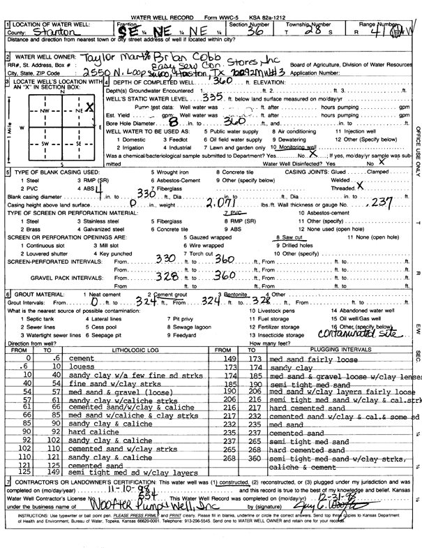
T28S, R41W, Sec. 36 SE NE NE |
Taylor Food Mart | 360 ft. | 335 ft. | Monitoring well/observation/piezometer | MW 3 | Plugged | 18-Nov-1999 | Scan | |
|
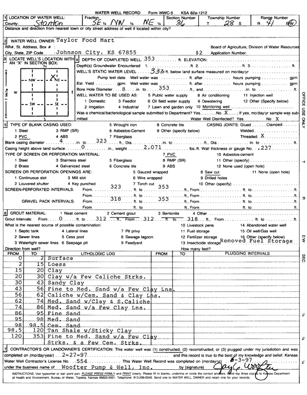
T28S, R41W, Sec. 36 SE NW NE |
Taylor Food Mart | 353 ft. | 333 ft. | Monitoring well/observation/piezometer | MW 2 | Constructed | 27-Feb-1997 | Scan | |
|
T28S, R41W, Sec. 36 SE NE NW |
Taylor Food Mart | 360 ft. | 335 ft. | Monitoring well/observation/piezometer | MW 3 | Constructed | 10-Nov-1998 | Scan | |
|
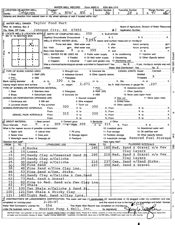
T28S, R41W, Sec. 36 SE NW NE |
Taylor Food Mart | 350 ft. | 337.5 ft. | Monitoring well/observation/piezometer | MW 1 | Constructed | 26-Feb-1997 | Scan | |
|
T28S, R42W, Sec. 1 NE NE SE |
Feiretag, Erwin | 338 ft. | 236 ft. | Irrigation | Constructed | 27-Aug-1976 | |||
|
T28S, R42W, Sec. 4 NE NE SE |
Batterton, Joe | 330 ft. | 245 ft. | Domestic | Constructed | 04-May-1992 | |||
|
T28S, R42W, Sec. 6 SW SE SE |
Farrar, Alice | 320 ft. | 220 ft. | Domestic | Constructed | 21-Nov-1980 | |||
|
T28S, R42W, Sec. 6 NE NE NW |
Walker, David | 531 ft. | 272 ft. | 500 gpm. | Irrigation | Constructed | 29-Mar-2023 |
KOLAR |
|
|
T28S, R42W, Sec. 7 C E2 NE |
Rains and Williamson Oil Co. | 280 ft. | 225 ft. | 30 gpm. | Oil Field Water Supply | McKee 1 | Constructed | 21-Feb-1980 | |
|
T28S, R42W, Sec. 8 NE NE NW |
Campbell, Howard | 320 ft. | 240 ft. | 20 gpm. | Domestic, Livestock | Constructed | 29-Aug-1988 | ||
|
T28S, R42W, Sec. 9 NW NW SW |
Mills, John and Carol | 500 ft. | 293 ft. | 10 gpm. | Domestic | Constructed | 21-Sep-2022 |
KOLAR |
|
|
T28S, R42W, Sec. 10 SE NE SE |
Westside Dairy | 350 ft. | 270 ft. | Domestic | Constructed | 09-Jun-2005 | |||
|
T28S, R42W, Sec. 11 NW NW NW |
Westside Dairy | 699 ft. | 272 ft. | Feedlot | Constructed | 11-Aug-2000 | Scan | ||
|
T28S, R42W, Sec. 14 SE SW NE NW |
Syracuse Dairy LLC | 669 ft. | 310 ft. | 238 gpm. | Irrigation | Constructed | 02-Apr-2015 |
KOLAR |
|
|
T28S, R42W, Sec. 14 SE SE SE NW |
Syracuse Dairy LLC | 691 ft. | 300 ft. | 500 gpm. | Irrigation | Constructed | 21-Oct-2021 |
KOLAR |
|
|
T28S, R42W, Sec. 19 SE SE SE |
Beredco Inc. | 340 ft. | Industrial | Constructed | 25-Jul-1986 | ||||
|
T28S, R42W, Sec. 24 SE SE SE |
Figgins, Jay | 360 ft. | 210 ft. | 50 gpm. | Domestic | Constructed | 18-Oct-1976 | ||
|
T28S, R42W, Sec. 26 NE SE NE |
Holiday, Paul | 500 ft. | Domestic | Constructed | 14-Apr-2010 | ||||
|
T28S, R42W, Sec. 26 NE SE NE |
Holiday, Paul | 268 ft. | 254 ft. | Domestic | Plugged | 11-May-2010 | |||
|
T28S, R42W, Sec. 26 NE SE NE |
Holiday, Paul | 264 ft. | 252 ft. | Domestic | Plugged | 11-May-2010 | |||
|
T28S, R42W, Sec. 26 SE SE NE |
Holliday, Paul | 271 ft. | 218 ft. | Domestic | Constructed | 24-Jun-1993 | |||
|
T28S, R42W, Sec. 27 NE NW NW |
Figgins, Robert | 558 ft. | 262 ft. | 10 gpm. | Domestic | Constructed | 04-Feb-2003 | Scan | |
|
T28S, R42W, Sec. 32 SE SE SE SE |
Loader, Wes | 100 ft. | 32 ft. | 12 gpm. | Domestic, Livestock | Constructed | 18-Nov-2016 | ||
|
T28S, R42W, Sec. 32 NE NE SE |
Nichols, Arlene | 290 ft. | 198 ft. | 20 gpm. | Domestic | Constructed | 03-Jun-1994 | ||
|
T28S, R42W, Sec. 32 NE NE SE |
Nichols, Arlene | 300 ft. | 100 ft. | 20 gpm. | Domestic | Constructed | 08-Oct-1994 | ||
|
T28S, R42W, Sec. 34 SW SW SW |
Hale, Hal | 160 ft. | 108 ft. | Domestic, Livestock | Constructed | 05-Oct-1980 | |||
|
T28S, R42W, Sec. 34 SE SE NW |
Loader, Delon | 290 ft. | 151 ft. | 40 gpm. | Domestic | Constructed | 17-Nov-1995 | ||
|
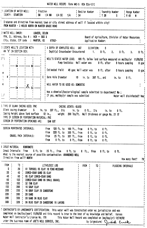
T28S, R42W, Sec. 34 SW NW SE |
Loader, Delon | 307 ft. | 188 ft. | 40 gpm. | Domestic | Constructed | 06-Nov-2002 | Scan | |
|
T28S, R42W, Sec. 34 SW NW SE |
Wilson, Marjorie E. | 150 ft. | 90 ft. | 20 gpm. | Domestic | Constructed | 30-Jan-1979 | ||
|
T28S, R43W, Sec. 27 SE NE NE |
J.M. Huber Corp. | 400 ft. | 200 ft. | 80 gpm. | Oil Field Water Supply | Tresner, 27-1 | Constructed | 13-Dec-1994 | |
| View page: 1 || 2 || 3 || 4 || 5 || 6 || 7 || 8 || 9 || 10 || Next > | |||||||||