Select location of well to view details.
Click on column heading to sort.
|
|
|
County: Stanton Select location of well to view details. Click on column heading to sort. |
|
|
|
| View page: < Prev || 11 || 12 || 13 || 14 || 15 || 16 || 17 || 18 || 19 || 20 || Next > | |||||||||
| T-R-S | Owner | Well Depth Ascend. Desc. |
Static Water Level Ascend. Desc. |
Est. Yield Ascend. Desc. |
Well Use | Other ID | Action Taken | Completion Date Ascend. Desc. |
Scan? |
|
T30S, R39W, Sec. 23 NW NW NW |
Shore, Lewis I. | 425 ft. | 255 ft. | Irrigation | Constructed | 11-May-2004 | Scan | ||
|
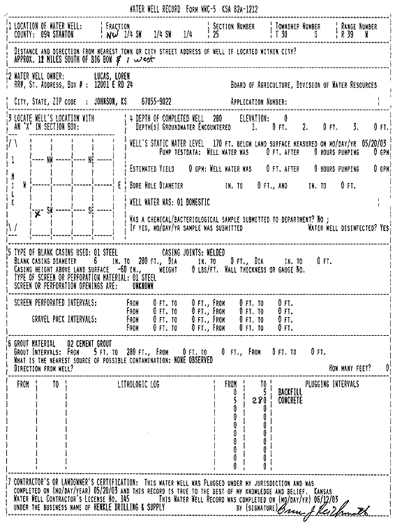
T30S, R39W, Sec. 25 NW SW SW |
Lucas, Loren | 405 ft. | 241 ft. | Domestic | Constructed | 15-May-2003 | Scan | ||
|
T30S, R39W, Sec. 25 NW SW SW |
Lucas, Loren | 280 ft. | 170 ft. | Domestic | Plugged | 20-May-2003 | Scan | ||
|
T30S, R39W, Sec. 26 SW SE SE SE |
Lucas, Loren | 490 ft. | 186 ft. | 30 gpm. | Domestic | Constructed | 15-Oct-2012 |
KOLAR |
|
|
T30S, R39W, Sec. 26 NW SW SW SE |
Lucas, Loren | 510 ft. | 282 ft. | 30 gpm. | Domestic | Constructed | 02-Jun-2020 | ||
|
T30S, R39W, Sec. 28 SW SW NE |
Maude Collingwood Trust | 370.6 ft. | 146 ft. | 1800 gpm. | Irrigation | Constructed | 08-Apr-1975 | ||
|
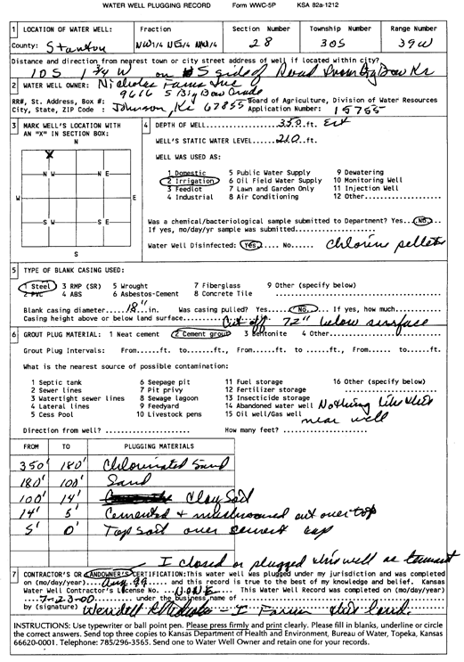
T30S, R39W, Sec. 28 NE NW NW |
Nicholas Farms | 560 ft. | 232 ft. | 1350 gpm. | Irrigation | Constructed | 10-Sep-1998 | Scan | |
|
T30S, R39W, Sec. 28 NW NE NW |
Nicholas Farms | 350 ft. | 210 ft. | Irrigation | Plugged | 01-Aug-1999 | Scan | ||
|
T30S, R39W, Sec. 30 NW NW NE |
Presco Western LLC | 500 ft. | 230 ft. | Oil Field Water Supply | Constructed | 10-Jan-2008 | |||
|
T30S, R39W, Sec. 32 SE SE SE |
Ellis, Wesley | 280 ft. | 175 ft. | 15 gpm. | Domestic | Constructed | 14-Dec-1976 | ||
|
T30S, R39W, Sec. 33 C NW |
Trans-Pacific Oil Corp. | 300 ft. | 175 ft. | 90 gpm. | Oil Field Water Supply | Constructed | 08-Feb-1991 | ||
|
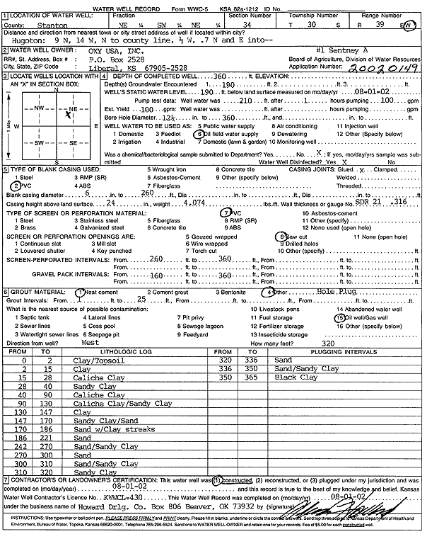
T30S, R39W, Sec. 34 NE SW NE |
Oxy USA, Inc. | 360 ft. | 190 ft. | 100 gpm. | Oil Field Water Supply | Sentney A-1 | Constructed | 01-Aug-2002 | Scan |
|
T30S, R39W, Sec. 36 SW SW SE SW |
Lucas, Loren | 465 ft. | 292 ft. | 903 gpm. | Irrigation | Constructed | 08-Mar-2016 |
KOLAR |
|
|
T30S, R39W, Sec. 36 SW NW NE |
Lucas, Loren | 495 ft. | Domestic | Constructed | 02-Mar-2010 | ||||
|
T30S, R39W, Sec. 36 NE NE NW |
Lucas, Loren | 256 ft. | Domestic | Plugged | 17-Mar-2010 | ||||
|
T30S, R40W, Sec. 1 SW NE SE |
Clawson, Mary | 540 ft. | 221 ft. | 2500 gpm. | Irrigation | Constructed | 07-Oct-1980 | ||
|
T30S, R40W, Sec. 1 NW NW |
Plummer, Bob | 545 ft. | 304 ft. | Irrigation | Constructed | 30-Apr-2010 | |||
|
T30S, R40W, Sec. 2 NE NW SW |
Herd, Kerry D. | 395 ft. | 800 gpm. | Irrigation | Reconstructed | 20-Jun-1989 | |||
|
T30S, R40W, Sec. 3 C SE |
Clawson, Kirby | 382 ft. | 186 ft. | 1451 gpm. | Irrigation | Constructed | 26-Apr-1977 | ||
|
T30S, R40W, Sec. 4 SW SW NW NW |
Dye, Pauline | 594 ft. | 340 ft. | 600 gpm. | Irrigation | Constructed | 23-May-2016 |
KOLAR |
|
|
T30S, R40W, Sec. 5 NE NE SW |
Dunklow, Martin | 340 ft. | 230 ft. | 850 gpm. | Irrigation | Constructed | 19-Jun-1980 | ||
|
T30S, R40W, Sec. 5 NW NW NE |
Martin, Robert and Janet | 541 ft. | 346 ft. | Irrigation | Constructed | 08-Jul-2008 | |||
|
T30S, R40W, Sec. 6 SE NW NE |
Julian Farms | 559 ft. | 260 ft. | 500 gpm. | Irrigation | Constructed | 10-Jun-1985 | ||
|
T30S, R40W, Sec. 7 NW NW NW |
Irene Lowe and Jennifer Thompson | 322 ft. | 218 ft. | 750 gpm. | Irrigation | Constructed | 15-Jun-1977 | ||
|
T30S, R40W, Sec. 8 NE NE NE |
Dunklau, Martin | 220 ft. | Irrigation | Plugged | 09-Jun-1993 | ||||
|
T30S, R40W, Sec. 8 SW SW SW |
Seaboard Farms | 360 ft. | 228 ft. | Domestic, Livestock | Shore 1 | Constructed | 05-Sep-1995 | ||
|
T30S, R40W, Sec. 8 SW SW SW |
Seaboard Farms | 401 ft. | 228 ft. | Domestic, Livestock | Shore 2 | Constructed | 11-Sep-1995 | ||
|
T30S, R40W, Sec. 9 SE SW SW |
Seaboard Farms | 298 ft. | 298 ft. | Domestic, Livestock | Shore 1 | Constructed | 12-Oct-1995 | ||
|
T30S, R40W, Sec. 9 SW SW SW |
Seaboard Farms | 460 ft. | 202 ft. | 100 gpm. | Feedlot | Shore F-238 | Constructed | 26-Jul-2002 | Scan |
|
T30S, R40W, Sec. 9 SW SW SE |
Seaboard Farms | 440 ft. | 211 ft. | 100 gpm. | Domestic, Livestock | Farm 238 | Constructed | 03-Jul-1996 | |
|
T30S, R40W, Sec. 10 NW NW NE |
Clawson, Kirby | 615 ft. | 245 ft. | Irrigation | Constructed | 07-Mar-1986 | |||
|
T30S, R40W, Sec. 10 SE SE SE |
Shore, Randy | 285 ft. | 195 ft. | 10 gpm. | Domestic | Constructed | 10-Sep-1983 | ||
|
T30S, R40W, Sec. 11 NW SW NE |
Barber Farms | 500 ft. | 240 ft. | Domestic | Constructed | 08-Nov-1980 | |||
|
T30S, R40W, Sec. 11 SW SW NE |
Harris Oil and Gas | 360 ft. | 288 ft. | 100 gpm. | Oil Field Water Supply | Barber Farms 1 | Constructed | 26-Mar-1998 | |
|
T30S, R40W, Sec. 11 NE NE NW |
Shore, Eugene | 351 ft. | 179 ft. | 1300 gpm. | Irrigation | Constructed | 23-May-1980 | ||
|
T30S, R40W, Sec. 12 NW NW NW |
Ralph Hodges Rev. Trust | 410 ft. | 215 ft. | Irrigation | Constructed | 13-Aug-1999 | Scan | ||
|
T30S, R40W, Sec. 12 NW NE NE NE |
Seaboard Farms Co. | 533 ft. | 340 ft. | 125 gpm. | Feedlot | Constructed | 25-Nov-2015 |
KOLAR |
|
|
T30S, R40W, Sec. 12 NW NE NE NE |
Seaboard Farms Co. | 390 ft. | 350 ft. | Feedlot | Plugged | 25-Nov-2015 |
KOLAR |
||
|
T30S, R40W, Sec. 12 NE NE NE |
Seaboard Farms Co. | 410 ft. | 265 ft. | Domestic, Livestock | Well 2, Farm 10 | Constructed | 11-May-1995 | ||
|
T30S, R40W, Sec. 12 NE NE NE |
Seaboard Farms Co. | 403 ft. | 265 ft. | Domestic, Livestock | Well 1, Farm 10 | Constructed | 18-May-1995 | ||
|
T30S, R40W, Sec. 12 NW NW NW |
Snook, Royce | 405 ft. | 193 ft. | 1200 gpm. | Irrigation | Constructed | 20-Apr-1976 | ||
|
T30S, R40W, Sec. 12 SE SE NE |
Snook, Royce | 545 ft. | 168 ft. | 1200 gpm. | Irrigation | Constructed | 20-Apr-1976 | ||
|
T30S, R40W, Sec. 20 C NE SW |
Charter Production Co. | 240 ft. | 210 ft. | 55 gpm. | Oil Field Water Supply | Feiertag B-1 | Constructed | 22-Jan-1994 | |
|
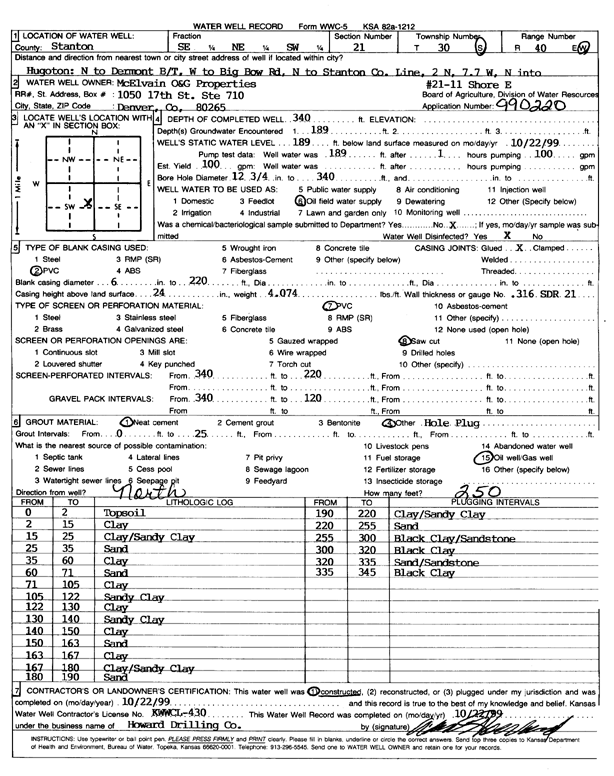
T30S, R40W, Sec. 21 SE NE SW |
McElvain Oil and Gas Properties | 340 ft. | 189 ft. | 100 gpm. | Oil Field Water Supply | Shore E 21-11 | Constructed | 22-Oct-1999 | Scan |
|
T30S, R40W, Sec. 21 SW SW SW |
Seaboard Farms | 276 ft. | 214 ft. | Domestic, Livestock | Shore 2 | Constructed | 30-Oct-1995 | ||
|
T30S, R40W, Sec. 21 SW SW SW |
Seaboard Farms | 260 ft. | 215 ft. | 126 gpm. | Other | Farm 108 | Constructed | 09-Jul-1997 | |
|
T30S, R40W, Sec. 21 SW SW SW |
Seaboard Farms | 277 ft. | 220 ft. | Domestic, Livestock | Shore 1 | Constructed | 24-Oct-1995 | ||
|
T30S, R40W, Sec. 22 NE NE NE |
Kersey, Lyle | 260 ft. | 202 ft. | 20 gpm. | Domestic | Constructed | 01-Mar-1996 | Scan | |
|
T30S, R40W, Sec. 22 NW SW SW |
Shore, Harold | 475 ft. | 201 ft. | 250 gpm. | Irrigation | Reconstructed | 23-Mar-1989 | ||
|
T30S, R40W, Sec. 24 NW SE SW |
Shore, Harold | 447 ft. | 193 ft. | 500 gpm. | Irrigation | Constructed | 28-Jun-1984 | ||
| View page: < Prev || 11 || 12 || 13 || 14 || 15 || 16 || 17 || 18 || 19 || 20 || Next > | |||||||||