Select location of well to view details.
Click on column heading to sort.
|
|
|
County: Stevens Select location of well to view details. Click on column heading to sort. |
|
|
|
| View page: < Prev || 31 || 32 || 33 || 34 || 35 || 36 || 37 || 38 || 39 || 40 || Next > | |||||||||
| T-R-S | Owner | Well Depth Ascend. Desc. |
Static Water Level Ascend. Desc. |
Est. Yield Ascend. Desc. |
Well Use | Other ID | Action Taken | Completion Date Ascend. Desc. |
Scan? |
|
T33S, R38W, Sec. 28 C NE NE |
Coulter, Rex | 440 ft. | 150 ft. | 70 gpm. | Domestic | Constructed | 27-Apr-1982 | ||
|
T33S, R38W, Sec. 29 NW SE SE |
Anadarko Petroleum Corp. | 420 ft. | 140 ft. | Oil Field Water Supply | Light U 1 | Plugged | 15-Mar-1994 | ||
|
T33S, R38W, Sec. 29 SW NE SW |
Gabbert and Jones | 340 ft. | 110 ft. | 65 gpm. | Oil Field Water Supply | Gregory E 1 | Constructed | 18-Dec-1988 | |
|
T33S, R38W, Sec. 29 NW NW NW |
Heaton, Ted | 340 ft. | 180 ft. | Domestic | Constructed | 08-Jul-1995 | |||
|
T33S, R38W, Sec. 29 SE SE NW |
Heaton, Ted | 420 ft. | 244 ft. | Domestic | Constructed | 23-Jun-2013 | |||
|
T33S, R38W, Sec. 29 NW SE SE |
Norseman Drilling | 420 ft. | 140 ft. | 100 gpm. | Oil Field Water Supply | Light U 1 | Constructed | 11-May-1993 | |
|
T33S, R38W, Sec. 29 SE SE SE |
Reynolds, Jack | 435 ft. | 195 ft. | Irrigation | Constructed | 27-Dec-1999 | Scan | ||
|
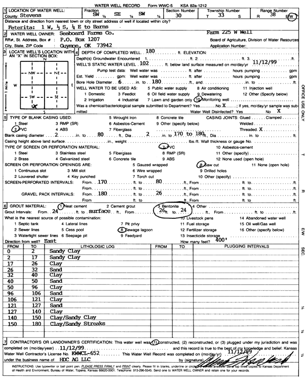
T33S, R38W, Sec. 30 SW SE SW |
Seaboard Farms Co. | 180 ft. | 102 ft. | Monitoring well/observation/piezometer | Farm 225 W Well | Constructed | 12-Nov-1999 | Scan | |
|
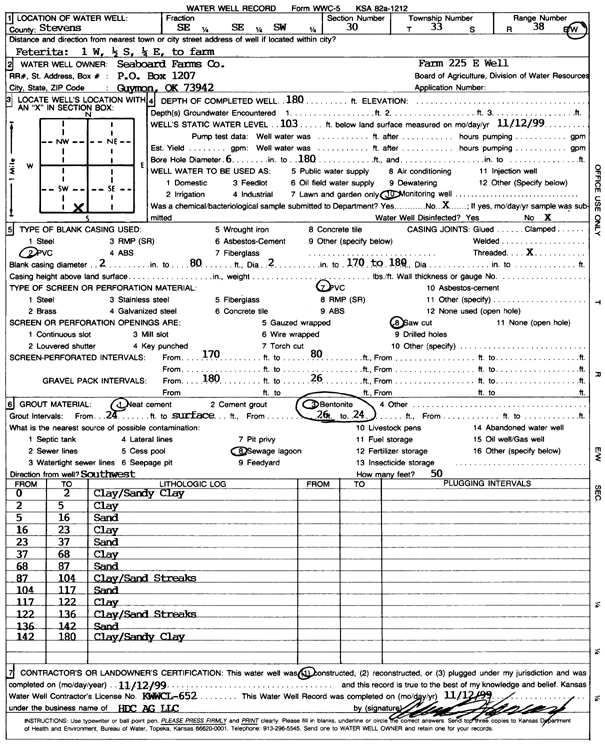
T33S, R38W, Sec. 30 SE SE SW |
Seaboard Farms Co. | 180 ft. | 103 ft. | Monitoring well/observation/piezometer | Farm 225 E Well | Constructed | 12-Nov-1999 | Scan | |
|
T33S, R38W, Sec. 31 SW SW NE |
Anadarko Petroleum Corp. | 380 ft. | 82 ft. | 100 gpm. | Oil Field Water Supply | Dowdy A-1 | Constructed | 13-Oct-1995 | |
|
T33S, R38W, Sec. 32 NE SW SE |
Gabbert and Jones | 400 ft. | 157 ft. | 55 gpm. | Oil Field Water Supply | Olson A-1 | Constructed | 23-Sep-1987 | |
|
T33S, R38W, Sec. 32 NE SW SE |
Gabbert and Jones | 400 ft. | 157 ft. | Oil Field Water Supply | Olson A-1 | Plugged | 05-Oct-1987 | ||
|
T33S, R38W, Sec. 33 C SE |
Anadarko Petroleum Corp./Dewey Mosey | 260 ft. | 141 ft. | 60 gpm. | Oil Field Water Supply | Moser B-1 | Constructed | 14-Jun-1984 | |
|
T33S, R38W, Sec. 33 C SE |
Anadarko Petroleum Corp./Dewey Mosey | 260 ft. | 141 ft. | 60 gpm. | Oil Field Water Supply | Moser B-1 | Plugged | 15-Jan-1985 | |
|
T33S, R38W, Sec. 33 NE NE NE |
Brecheisen, Mrs. C.P. | 385 ft. | 160 ft. | 20 gpm. | Domestic | Constructed | 04-Apr-1985 | ||
|
T33S, R38W, Sec. 33 NW SW SE SW |
Morgan, Eric | 420 ft. | 205 ft. | 25 gpm. | Domestic | Constructed | 21-Nov-2012 |
KOLAR |
|
|
T33S, R38W, Sec. 33 NE NE SW |
Morgan, Eric | 505 ft. | 195 ft. | 1600 gpm. | Irrigation | Constructed | 23-Jan-1997 | ||
|
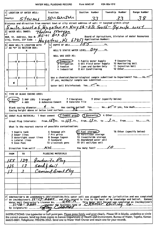
T33S, R38W, Sec. 33 SE SW SW |
Morgan, Thelma | 155 ft. | Domestic | Plugged | 13-Nov-2000 | Scan | |||
|
T33S, R38W, Sec. 33 SE SE SE |
Rowden, Jon | 320 ft. | 201 ft. | Domestic | Constructed | 03-Jun-1998 | |||
|
T33S, R38W, Sec. 34 NE |
Minter, Edith Brecheisen | 555 ft. | 147 ft. | 1475 gpm. | Irrigation | Constructed | 20-Feb-1980 | ||
|
T33S, R38W, Sec. 35 SW SE SW |
Gabbert and Jones | 300 ft. | 145 ft. | 75 gpm. | Oil Field Water Supply | Dunne-Hoffman D-2 | Constructed | 27-Oct-1989 | |
|
T33S, R38W, Sec. 35 SW SW NW |
Johnson, Kyle | 495 ft. | 284 ft. | 20 gpm. | Domestic, Livestock | Constructed | 09-Jan-2025 |
KOLAR |
|
|
T33S, R38W, Sec. 35 NW NW NE |
Morgan, Ray | 428 ft. | 128 ft. | 3000 gpm. | Irrigation | Constructed | 30-Apr-1976 | ||
|
T33S, R39W, Sec. 1 NW NE NE |
Lester, Beverly | 425 ft. | 209 ft. | 400 gpm. | Irrigation | Constructed | 29-Sep-1997 | ||
|
T33S, R39W, Sec. 1 NW NE NE |
Lester, Beverly | 428 ft. | 209 ft. | Irrigation | Plugged | 04-Nov-1997 | |||
|
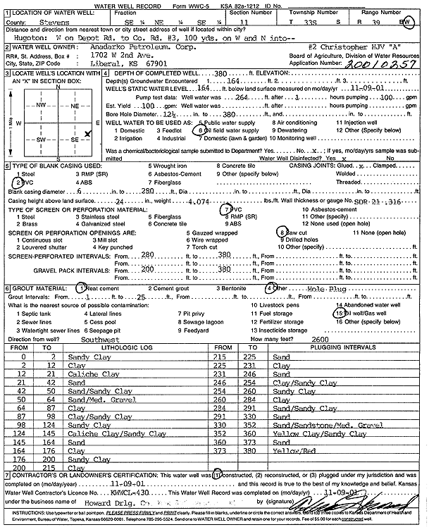
T33S, R39W, Sec. 2 SW SE SE |
Anadarko Petroleum Corp. | 320 ft. | 180 ft. | 50 gpm. | Oil Field Water Supply | HJV Christopher A-1 | Constructed | 11-Jul-2000 | Scan |
|
T33S, R39W, Sec. 2 SE SE SE |
Anadarko Petroleum Corp. | 260 ft. | 120 ft. | 20 gpm. | Domestic | Constructed | 25-Jul-1990 | ||
|
T33S, R39W, Sec. 2 NE NE SW |
Anadarko Petroleum Corp. | 350 ft. | 150 ft. | 30 gpm. | Domestic | Constructed | 20-Apr-1994 | ||
|
T33S, R39W, Sec. 11 SE NE SE |
Anadarko Petroleum Corp. | 380 ft. | 164 ft. | 100 gpm. | Oil Field Water Supply | Christopher HJV A-2 | Constructed | 09-Nov-2001 | Scan |
|
T33S, R39W, Sec. 11 NE NE SW |
Bazone, Sam | 342 ft. | 112 ft. | 1750 gpm. | Irrigation | Constructed | 09-Oct-1976 | ||
|
T33S, R39W, Sec. 11 NW SE NW |
Mobil Oil Corp. | 360 ft. | 170 ft. | Oil Field Water Supply | Christopher 2 Unit 4 | Plugged | 15-Mar-1994 | ||
|
T33S, R39W, Sec. 11 NW SE NW |
Mobil Oil Corp. | 360 ft. | 170 ft. | 120 gpm. | Oil Field Water Supply | Christopher 2 Unit 4 | Constructed | 21-Sep-1993 | |
|
T33S, R39W, Sec. 12 NE SE SW |
Flummerfelt, June | 399 ft. | 208 ft. | Irrigation | Constructed | 01-Jul-2011 | |||
|
T33S, R39W, Sec. 12 NW NW SW |
Flummerfelt, June | 396 ft. | 175 ft. | Irrigation | Constructed | 10-Jul-2007 | |||
|
T33S, R39W, Sec. 12 SW SW NW |
Flummerfelt, L.W. | 320 ft. | 122 ft. | Irrigation | Constructed | 30-Nov-1984 | |||
|
T33S, R39W, Sec. 12 SW SW SE |
Flummerfelt, L.W. | 340 ft. | 180 ft. | 50 gpm. | Domestic | Constructed | 28-Feb-1983 | ||
|
T33S, R39W, Sec. 12 NE SE SW |
Gary Norton and June Flummerfelt Trust | 320 ft. | 204 ft. | Irrigation | Plugged | 14-Nov-2011 | |||
|
T33S, R39W, Sec. 12 SW SW NW |
Norton, Garry | 400 ft. | 180 ft. | Irrigation | Plugged | 27-Mar-2008 | |||
|
T33S, R39W, Sec. 14 NE NE NE |
Olinger, Donald | 330 ft. | 180 ft. | 40 gpm. | Domestic | Constructed | 08-Jun-1983 | ||
|
T33S, R39W, Sec. 15 NW SE SE |
Gabbert and Jones | 380 ft. | 160 ft. | Oil Field Water Supply | Texaco A-1 | Plugged | 05-Jul-1989 | ||
|
T33S, R39W, Sec. 15 NW SE SE |
Gabbert and Jones | 380 ft. | 160 ft. | 60 gpm. | Oil Field Water Supply | Texaco A-1 | Constructed | 17-Aug-1988 | |
|
T33S, R39W, Sec. 22 SE SW SW |
Demuth, W.E. | 160 ft. | 80 ft. | 20 gpm. | Domestic, Livestock | Constructed | 27-Sep-1977 | ||
|
T33S, R39W, Sec. 22 C SW |
Gabbert and Jones | 340 ft. | 90 ft. | Oil Field Water Supply | Demuth B-2H | Plugged | 25-Jul-1987 | ||
|
T33S, R39W, Sec. 22 C SW |
Gabbert and Jones | 340 ft. | 90 ft. | 60 gpm. | Oil Field Water Supply | Demuth B-2H | Constructed | 13-Mar-1987 | |
|
T33S, R39W, Sec. 23 N2 S2 NW |
Anadarko Petroleum Corp. | 380 ft. | 100 ft. | 120 gpm. | Oil Field Water Supply | Demuth B-3 | Constructed | 26-Apr-1995 | |
|
T33S, R39W, Sec. 23 SE NW SW |
Anadarko Petroleum Corp. | 380 ft. | 110 ft. | 110 gpm. | Oil Field Water Supply | KU Endowment D-2 | Constructed | 30-Jan-1997 | |
|
T33S, R39W, Sec. 23 SE SE SW |
Jordan, Terry | 427 ft. | 149 ft. | 50 gpm. | Domestic | Constructed | 28-Mar-2014 | ||
|
T33S, R39W, Sec. 24 C NE NE |
Anadarko Petroleum Corp. | 340 ft. | 131 ft. | 100 gpm. | Oil Field Water Supply | Gregory D-2 | Constructed | 24-May-1997 | |
|
T33S, R39W, Sec. 24 NW SW SW |
Light, James | 423 ft. | Irrigation | Constructed | 09-May-1975 | ||||
|
T33S, R39W, Sec. 24 SW SE SE |
McClure, Ben | 400 ft. | 158 ft. | Domestic | Constructed | 22-Jun-2023 |
KOLAR |
||
| View page: < Prev || 31 || 32 || 33 || 34 || 35 || 36 || 37 || 38 || 39 || 40 || Next > | |||||||||