Select location of well to view details.
Click on column heading to sort.
|
|
|
County: Stevens Select location of well to view details. Click on column heading to sort. |
|
|
|
| View page: 1 || 2 || 3 || 4 || 5 || 6 || 7 || 8 || 9 || 10 || Next > | |||||||||
| T-R-S | Owner | Well Depth Ascend. Desc. |
Static Water Level Ascend. Desc. |
Est. Yield Ascend. Desc. |
Well Use | Other ID | Action Taken | Completion Date Ascend. Desc. |
Scan? |
|
T31S, R36W, Sec. 7 NW SW NW |
Brollier, Sherm | 510 ft. | 230 ft. | 1600 gpm. | Irrigation | Constructed | 26-Sep-1991 | ||
|
T31S, R36W, Sec. 7 SE NW NW NW |
McBride Investments | 502 ft. | 259 ft. | 50 gpm. | Domestic | Constructed | 08-Dec-2020 |
KOLAR |
|
|
T31S, R36W, Sec. 7 NE SE NW |
Mobil Oil Corp./W.J. Fox | 360 ft. | 253 ft. | 75 gpm. | Oil Field Water Supply | Constructed | 11-Aug-1988 | ||
|
T31S, R36W, Sec. 9 SE SE SE |
Owens, Mike | 405 ft. | 182 ft. | 50 gpm. | Domestic | Constructed | 12-Aug-2008 | ||
|
T31S, R36W, Sec. 9 NW NW NE |
Shriver, Wanda | 487 ft. | 157 ft. | 500 gpm. | Irrigation | Constructed | 09-May-1990 | ||
|
T31S, R36W, Sec. 9 SW SW NE |
Shriver, Wanda | 283 ft. | 145 ft. | Irrigation | Plugged | 13-Jun-1990 | |||
|
T31S, R36W, Sec. 10 C SE SE |
Anadarko Petroleum Corp. | 420 ft. | 160 ft. | 90 gpm. | Oil Field Water Supply | Lahey B-1 | Constructed | 08-Feb-1996 | |
|
T31S, R36W, Sec. 10 SE SE NE |
Gilbert, Mrs. O.T. | 514 ft. | 166 ft. | 900 gpm. | Irrigation | Constructed | 07-Jul-1975 | ||
|
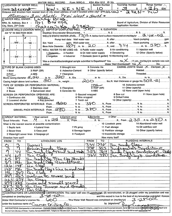
T31S, R36W, Sec. 10 NW NE NE |
Lahey Bros. | 380 ft. | 170 ft. | Domestic | Constructed | 15-Mar-2002 | Scan | ||
|
T31S, R36W, Sec. 10 SW SW SW SW |
Lahey, Evan | 400 ft. | 172 ft. | 50 gpm. | Domestic | Constructed | 20-Mar-2018 | ||
|
T31S, R36W, Sec. 10 C NE |
Lahey, Tom | 326 ft. | 155 ft. | 708 gpm. | Irrigation | Constructed | 30-Mar-1975 | ||
|
T31S, R36W, Sec. 10 NW SE NE |
Lahey, Tom | 480 ft. | 180 ft. | Irrigation | Constructed | 09-Jul-1997 | |||
|
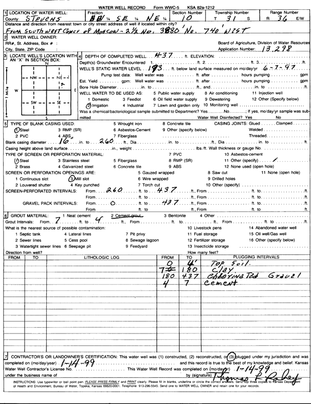
T31S, R36W, Sec. 10 NW SE NE |
Lahey, Tom | 437 ft. | 193 ft. | Irrigation | Plugged | 14-Jan-1999 | Scan | ||
|
T31S, R36W, Sec. 10 SE SW SW |
Lahey, Vance | 390 ft. | 200 ft. | Domestic | Constructed | 27-May-1987 | |||
|
T31S, R36W, Sec. 11 SE NE NE |
Gilbert, Ralph | 535 ft. | 232 ft. | Irrigation | Constructed | 19-Jun-1987 | |||
|
T31S, R36W, Sec. 11 SE NE NE |
Gilbert, Ralph | 461 ft. | 241 ft. | Irrigation | Plugged | 16-Nov-1990 | |||
|
T31S, R36W, Sec. 11 NE SE NE NE |
Lahey, Tom | 541 ft. | 277 ft. | 300 gpm. | Irrigation | Constructed | 13-Jul-2017 |
KOLAR |
|
|
T31S, R36W, Sec. 12 SW NW NE |
Lahey, Thomas | 576 ft. | 328 ft. | Irrigation | 1-25 | Constructed | 15-Apr-2025 |
KOLAR |
|
|
T31S, R36W, Sec. 12 NW NE NW |
Lee, Betty | 551 ft. | 220 ft. | 1600 gpm. | Irrigation | Constructed | 23-Apr-1975 | ||
|
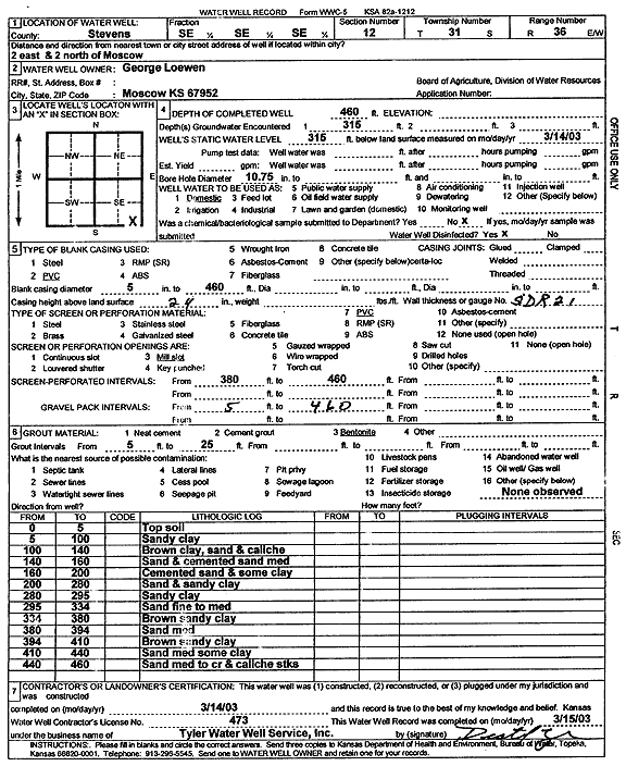
T31S, R36W, Sec. 12 SE SE SE |
Loewen, George | 460 ft. | 315 ft. | Domestic | Constructed | 14-Mar-2003 | Scan | ||
|
T31S, R36W, Sec. 12 SW NW NE |
Munson, Christine | 560 ft. | 220 ft. | Irrigation | Constructed | 30-Oct-1996 | |||
|
T31S, R36W, Sec. 13 SW NE NW |
Mobil Oil Corp./Floy C. Hocrasser | 460 ft. | 203 ft. | 110 gpm. | Oil Field Water Supply | H.H. Brownell Unit 3 | Plugged | 26-Jan-1988 | |
|
T31S, R36W, Sec. 13 SW NE NW |
Mobil Oil Corp./Floy C. Hocrasser | 460 ft. | 203 ft. | 110 gpm. | Oil Field Water Supply | H.H. Brownell Unit 3 | Constructed | 03-Dec-1987 | |
|
T31S, R36W, Sec. 14 NW NW SE |
Beredco Inc. | 460 ft. | 240 ft. | Oil Field Water Supply | Claretta 2-14 | Plugged | 14-Dec-1995 | ||
|
T31S, R36W, Sec. 14 NW NW SE |
Beredco Inc. | 460 ft. | 5 gpm. | Oil Field Water Supply | Claretta 2-14 | Constructed | 13-Apr-1995 | ||
|
T31S, R36W, Sec. 14 NE NW SE |
Gaskill, Alvin | 498 ft. | Irrigation | Constructed | 26-May-1975 | ||||
|
T31S, R36W, Sec. 14 NW NE SE |
Gaskill, Mike | 490 ft. | 234 ft. | Irrigation | Plugged | 11-Nov-2011 | |||
|
T31S, R36W, Sec. 14 SW SW NE |
Gaskill, Mike | 521 ft. | 240 ft. | 400 gpm. | Irrigation | Constructed | 05-Apr-2006 | ||
|
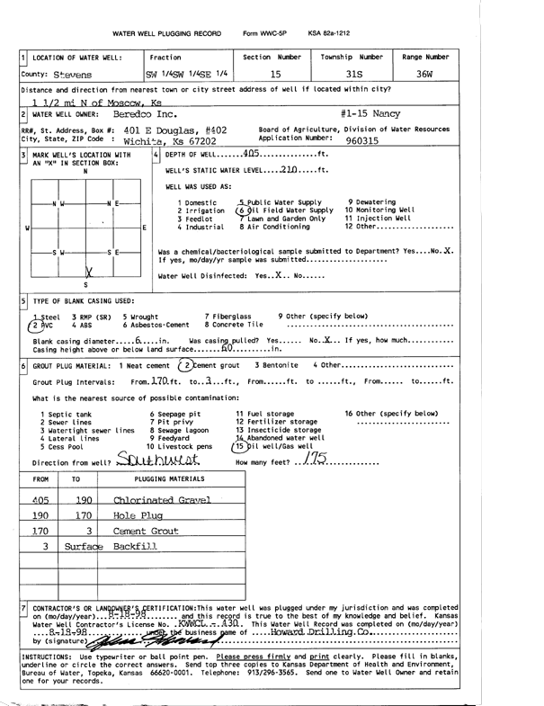
T31S, R36W, Sec. 15 SW SW SE |
Beredco Inc. | 405 ft. | 210 ft. | Oil Field Water Supply | Nancy 1-15 | Plugged | 18-Aug-1998 | Scan | |
|
T31S, R36W, Sec. 15 SE SW SE |
Berexco Inc. | 405 ft. | 210 ft. | 110 gpm. | Oil Field Water Supply | Nancy 1-15 | Constructed | 17-Sep-1996 | |
|
T31S, R36W, Sec. 16 NW NW SW NE |
Lahey, Tom | 512 ft. | 228 ft. | 283 gpm. | Irrigation | Constructed | 27-Jan-2012 |
KOLAR |
|
|
T31S, R36W, Sec. 17 SW SE NE |
Lahey, Thomas | 518 ft. | 304 ft. | Irrigation | Constructed | 15-Jan-2025 |
KOLAR |
||
|
T31S, R36W, Sec. 17 SE SE NE |
Lahey, Tom | 472.11 ft. | 180 ft. | 1800 gpm. | Irrigation | Constructed | 17-Apr-1981 | ||
|
T31S, R36W, Sec. 18 NE SW NE |
EOG Resources Inc | 400 ft. | 250 ft. | 100 gpm. | Oil Field Water Supply | Loewen Fisher 18-1 | Constructed | 26-Nov-2007 | |
|
T31S, R36W, Sec. 19 SW NW NE |
Mobil Oil Corp. | 260 ft. | 200 ft. | 125 gpm. | Oil Field Water Supply | Constructed | 25-Jul-1990 | ||
|
T31S, R36W, Sec. 19 SW NW NE |
Mobil Oil Corp. | 260 ft. | 200 ft. | Oil Field Water Supply | Plugged | 14-Dec-1995 | |||
|
T31S, R36W, Sec. 20 NW NW NW |
Reynolds, Wayne | 514 ft. | 303 ft. | 1791 gpm. | Irrigation | Constructed | 08-Dec-2022 |
KOLAR |
|
|
T31S, R36W, Sec. 23 NW NW NW |
Dorsey, Tom | 480 ft. | 190 ft. | 70 gpm. | Domestic | Constructed | 25-Mar-1995 | ||
|
T31S, R36W, Sec. 23 NW SE SE |
Ensign Operating Co. | 390 ft. | 265 ft. | 65 gpm. | Oil Field Water Supply | Grandstaff 1-23 | Constructed | 31-Jul-1991 | |
|
T31S, R36W, Sec. 23 NW NW NE |
Teeter, Jim | 292 ft. | 165 ft. | 20 gpm. | Domestic | Constructed | 22-Mar-1976 | ||
|
T31S, R36W, Sec. 24 NW SE |
May, Davis | 520 ft. | 220 ft. | 50 gpm. | Domestic | Constructed | 15-Aug-1994 | ||
|
T31S, R36W, Sec. 24 SW NE NE |
Mobil Oil Corp./Monty Munson | 440 ft. | 216 ft. | 100 gpm. | Oil Field Water Supply | William Mast B-3 | Constructed | 13-Sep-1988 | |
|
T31S, R36W, Sec. 24 NE NW NW |
Moscow Equity | 428 ft. | 218 ft. | Domestic | Constructed | 17-Jun-1987 | |||
|
T31S, R36W, Sec. 25 NW SW |
Brollier, Carl | 500 ft. | 196 ft. | 700 gpm. | Irrigation | Constructed | 21-Feb-1975 | ||
|
T31S, R36W, Sec. 25 SE SW NW |
Gaskill, Mike | 460 ft. | 290 ft. | Irrigation | Plugged | 17-Jan-2012 | |||
|
T31S, R36W, Sec. 25 C NW NW |
Mobil Oil Corp./Mike Gaskill | 400 ft. | 207 ft. | 100 gpm. | Oil Field Water Supply | E.A. Loomis Unit 3 | Plugged | 10-Aug-1989 | |
|
T31S, R36W, Sec. 25 C NW NW |
Mobil Oil Corp./Mike Gaskill | 400 ft. | 207 ft. | 100 gpm. | Oil Field Water Supply | E.A. Loomis Unit 3 | Constructed | 25-Mar-1989 | |
|
T31S, R36W, Sec. 26 SE SW SW |
City of Moscow | 530 ft. | 190 ft. | Public Water Supply | Constructed | 13-Oct-1981 | |||
|
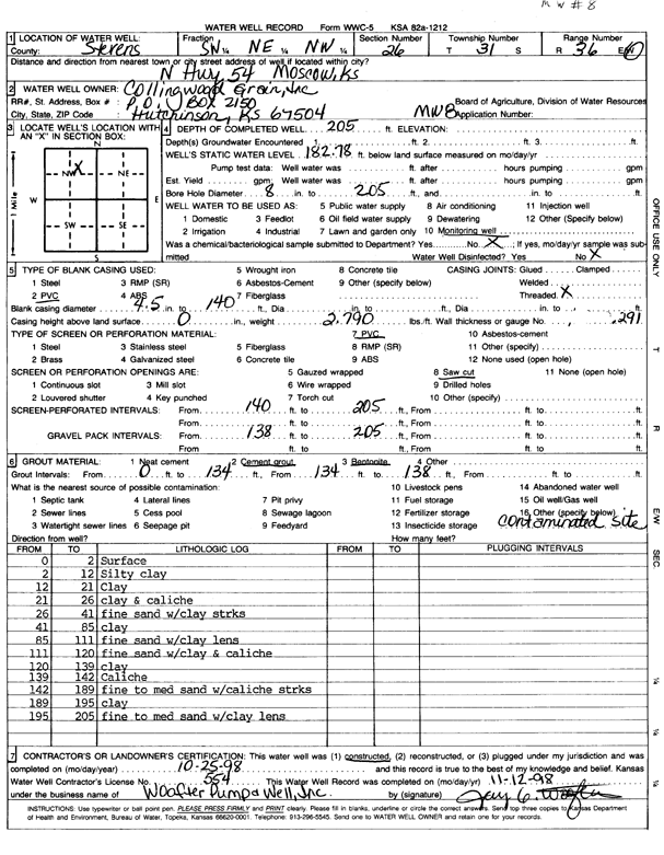
T31S, R36W, Sec. 26 SW NE NW |
Collingwood Grain, Inc. | 205 ft. | 182.8 ft. | Monitoring well/observation/piezometer | MW 8 | Constructed | 25-Oct-1998 | Scan | |
|
T31S, R36W, Sec. 26 SW SW NW |
Collingwood Grain, Inc. | 20.1 ft. | Environmental Remediation, Soil Vapor Extraction | TSVE 1 | Plugged | 23-Sep-2009 | |||
| View page: 1 || 2 || 3 || 4 || 5 || 6 || 7 || 8 || 9 || 10 || Next > | |||||||||