Select location of well to view details.
Click on column heading to sort.
|
|
|
County: Stevens Select location of well to view details. Click on column heading to sort. |
|
|
|
| View page: 1 || 2 || 3 || 4 || 5 || 6 || 7 || 8 || 9 || 10 || Next > | |||||||||
| T-R-S | Owner | Well Depth Ascend. Desc. |
Static Water Level Ascend. Desc. |
Est. Yield Ascend. Desc. |
Well Use | Other ID | Action Taken | Completion Date Ascend. Desc. |
Scan? |
|
T31S, R36W, Sec. 26 SW SW NW |
Collingwood Grain, Inc. | 20.1 ft. | Environmental Remediation, Soil Vapor Extraction | TSVE 1 | Plugged | 23-Sep-2009 | |||
|
T31S, R36W, Sec. 26 NE SW NW |
Collingwood Grain, Inc. | 270 ft. | 197.5 ft. | Monitoring well/observation/piezometer | MW 3 | Constructed | 12-Dec-1997 | ||
|
T31S, R36W, Sec. 26 SW SE SE NW |
Collingwood Grain, Inc. | 205 ft. | 197.81 ft. | Monitoring well/observation/piezometer | MW 14 | Constructed | 11-Feb-2010 | ||
|
T31S, R36W, Sec. 26 NE SW NW |
Collingwood Grain, Inc. | 19.3 ft. | Environmental Remediation, Soil Vapor Extraction | TSVE 3 | Plugged | 23-Sep-2009 | |||
|
T31S, R36W, Sec. 26 SW SW SE NW |
Collingwood Grain, Inc. | 205 ft. | Monitoring well/observation/piezometer | MW 9 | Constructed | 10-Feb-2010 | |||
|
T31S, R36W, Sec. 26 NW SW SE NW |
Collingwood Grain, Inc. | 205 ft. | 179.69 ft. | Monitoring well/observation/piezometer | MW 11 | Constructed | 09-Feb-2010 | ||
|
T31S, R36W, Sec. 26 NE SW SE NW |
Collingwood Grain, Inc. | 205 ft. | 199.7 ft. | Monitoring well/observation/piezometer | MW 13 | Constructed | 15-Feb-2010 | ||
|
T31S, R36W, Sec. 26 SW SW NW |
Collingwood Grain, Inc. | 39 ft. | Environmental Remediation, Soil Vapor Extraction | SVE 5 | Plugged | 07-Jul-2009 | |||
|
T31S, R36W, Sec. 26 SW SW NW |
Collingwood Grain, Inc. | 20.3 ft. | Environmental Remediation, Soil Vapor Extraction | TSVE 2 | Plugged | 23-Sep-2009 | |||
|
T31S, R36W, Sec. 26 NW NE NW SW |
Collingwood Grain, Inc. | 210 ft. | Monitoring well/observation/piezometer | MW 12 | Constructed | 15-Feb-2010 | |||
|
T31S, R36W, Sec. 26 SE SE SW NW |
Collingwood Grain, Inc. | 205 ft. | 184.82 ft. | Monitoring well/observation/piezometer | MW 10 | Constructed | 10-Feb-2010 | ||
|
T31S, R36W, Sec. 26 NE SW NW |
Collingwood Grain, Inc. | 24.3 ft. | Environmental Remediation, Soil Vapor Extraction | SVE 3 | Plugged | 23-Sep-2009 | |||
|
T31S, R36W, Sec. 26 SW SW NW |
Collingwood Grain, Inc. | 39 ft. | Environmental Remediation, Soil Vapor Extraction | SVE 5 | Plugged | 07-Jul-2009 | |||
|
T31S, R36W, Sec. 26 SW SW NW |
Collingwood Grain, Inc. | 200 ft. | Environmental Remediation, Soil Vapor Extraction | SVED 4 M | Plugged | 23-Sep-2009 | |||
|
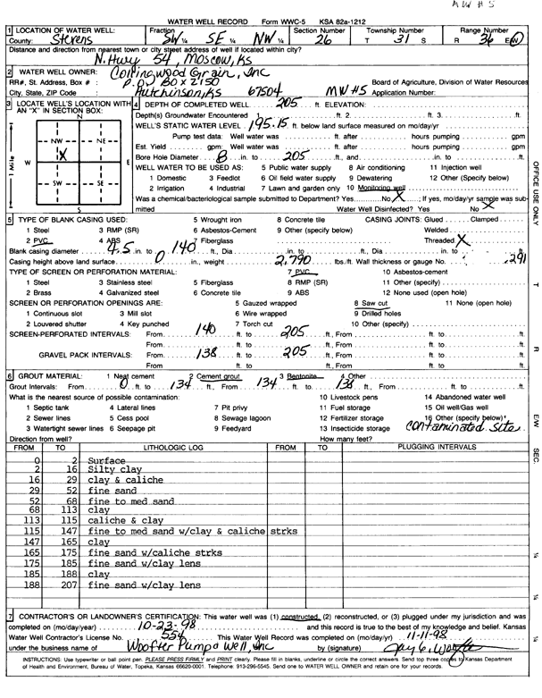
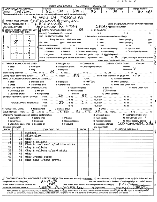
T31S, R36W, Sec. 26 SW SE NW |
Collingwood Grain, Inc. | 205 ft. | 195.2 ft. | Monitoring well/observation/piezometer | MW 5 | Constructed | 23-Oct-1998 | Scan | |
|
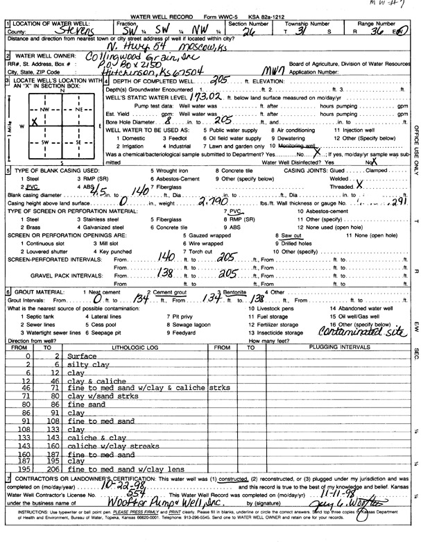
T31S, R36W, Sec. 26 SW SW NW |
Collingwood Grain, Inc. | 205 ft. | 173.02 ft. | Monitoring well/observation/piezometer | MW 7 | Constructed | 22-Oct-1998 | Scan | |
|
T31S, R36W, Sec. 26 NE SW NW |
Collingwood Grain, Inc. | 235 ft. | 200 ft. | Monitoring well/observation/piezometer | SVE 6 | Constructed | 14-Dec-1997 | ||
|
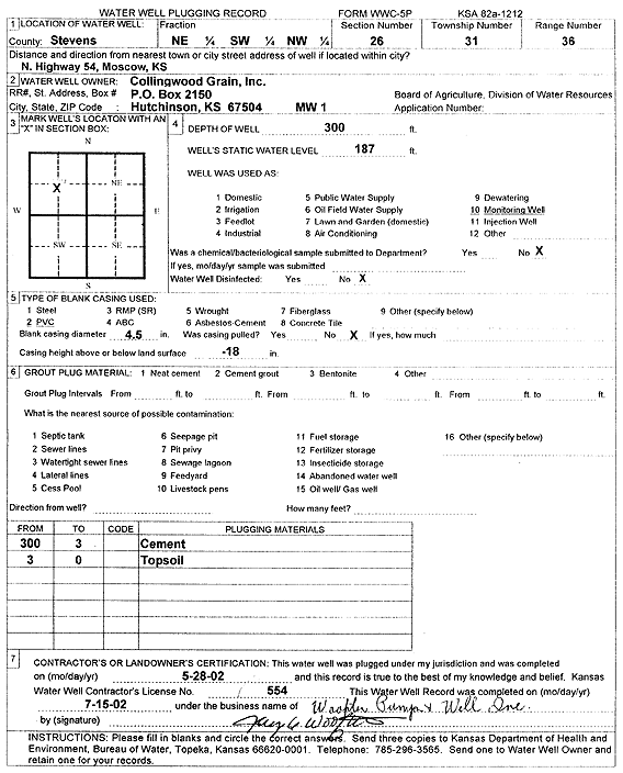
T31S, R36W, Sec. 26 NE SW NW |
Collingwood Grain, Inc. | 300 ft. | 187 ft. | Monitoring well/observation/piezometer | MW 1 | Plugged | 28-May-2002 | Scan | |
|
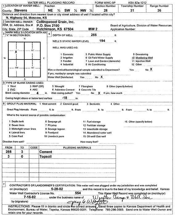
T31S, R36W, Sec. 26 NW SW NW |
Collingwood Grain, Inc. | 266 ft. | 194 ft. | Monitoring well/observation/piezometer | MW 2 | Plugged | 28-May-2002 | Scan | |
|
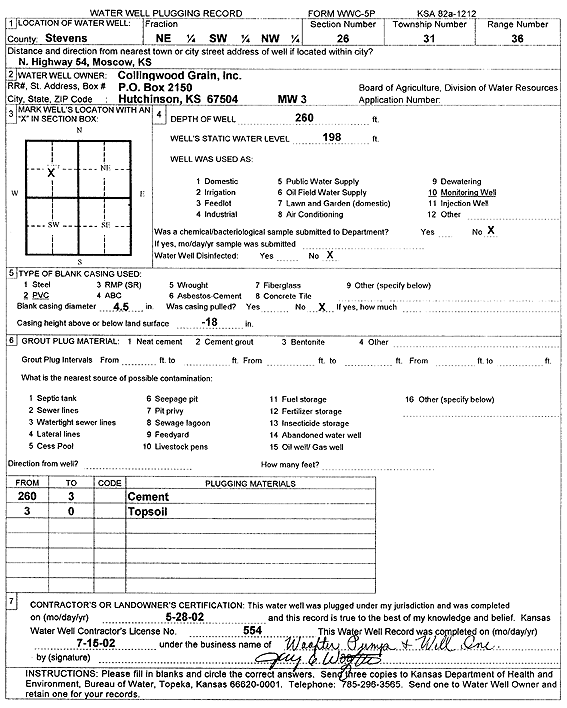
T31S, R36W, Sec. 26 NE SW NW |
Collingwood Grain, Inc. | 260 ft. | 198 ft. | Monitoring well/observation/piezometer | MW 3 | Plugged | 28-May-2002 | Scan | |
|
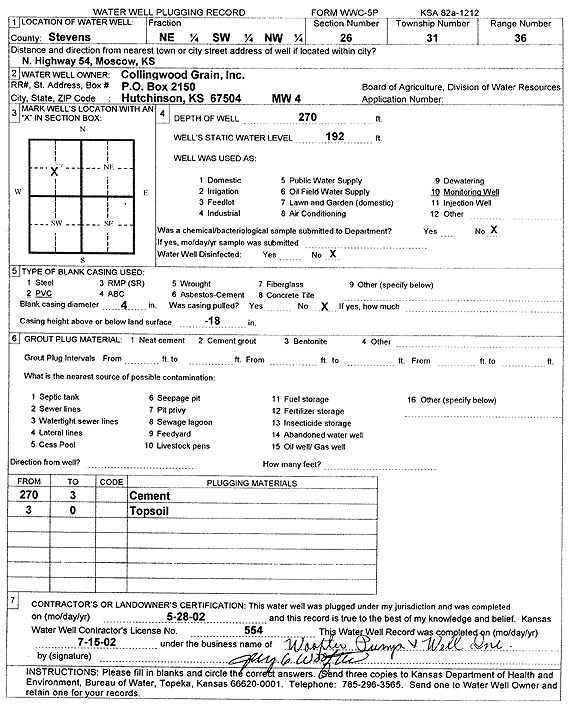
T31S, R36W, Sec. 26 NE SW NW |
Collingwood Grain, Inc. | 270 ft. | 192 ft. | Monitoring well/observation/piezometer | MW 4 | Plugged | 28-May-2002 | Scan | |
|
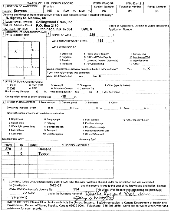
T31S, R36W, Sec. 26 NE SW NW |
Collingwood Grain, Inc. | 235 ft. | 192 ft. | Monitoring well/observation/piezometer | SVE 6 | Plugged | 28-May-2002 | Scan | |
|
T31S, R36W, Sec. 26 SW SW NW |
Collingwood Grain, Inc. | 60.5 ft. | Environmental Remediation, Soil Vapor Extraction | SVE 4 | Plugged | 23-Sep-2009 | |||
|
T31S, R36W, Sec. 26 NW SW NW |
Collingwood Grain, Inc. | 276.1 ft. | 234.66 ft. | Monitoring well/observation/piezometer | CW 2 | Plugged | 01-Mar-2010 | ||
|
T31S, R36W, Sec. 26 SE SW NW |
Collingwood Grain, Inc. | 270 ft. | 202 ft. | Monitoring well/observation/piezometer | MW 4 | Constructed | 13-Dec-1997 | ||
|
T31S, R36W, Sec. 26 SW SW NW |
Collingwood Grain, Inc. | 266 ft. | 198 ft. | Monitoring well/observation/piezometer | MW 2 | Constructed | 11-Dec-1997 | ||
|
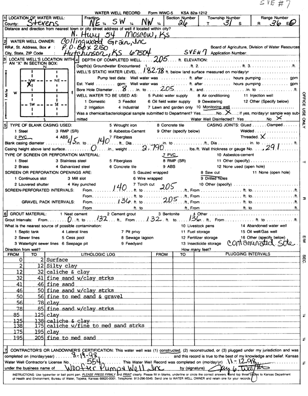
T31S, R36W, Sec. 26 NE SW NW |
Collingwood Grain, Inc. | 205 ft. | 182.8 ft. | Monitoring well/observation/piezometer | SVE 7 | Constructed | 19-Aug-1998 | Scan | |
|
T31S, R36W, Sec. 26 NE SW NW |
Collingwood Grain, Inc. | 55 ft. | Monitoring well/observation/piezometer | SVE 8 | Constructed | 21-Oct-1998 | Scan | ||
|
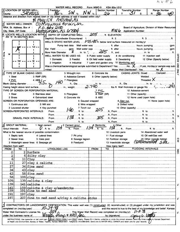
T31S, R36W, Sec. 26 NE SW NW |
Collingwood Grain, Inc. | 205 ft. | 175.5 ft. | Monitoring well/observation/piezometer | MW 6 | Constructed | 24-Oct-1998 | Scan | |
|
T31S, R36W, Sec. 26 SE SW NW |
Collingwood Grain, Inc. | 300 ft. | 197 ft. | Monitoring well/observation/piezometer | MW 1 | Constructed | 10-Dec-1997 | ||
|
T31S, R36W, Sec. 26 SW SW NW |
Collingwood Grain, Inc. | 60.8 ft. | Environmental Remediation, Soil Vapor Extraction | SVE 9 | Plugged | 23-Sep-2009 | |||
|
T31S, R36W, Sec. 26 SW SW NW |
Collingwood Grain, Inc. | 200 ft. | (unstated)/abandoned | Plugged | 23-Sep-2009 | ||||
|
T31S, R36W, Sec. 26 SE SW NW |
Collingwood Grain, Inc. | 60.8 ft. | Environmental Remediation, Soil Vapor Extraction | SVE 10 | Plugged | 23-Sep-2009 | |||
|
T31S, R36W, Sec. 26 SW SW NW |
Collingwood Grain, Inc. | 205 ft. | Environmental Remediation, Air Sparge | IAS 1 | Plugged | 23-Sep-2009 | |||
|
T31S, R36W, Sec. 26 SW SW NW |
Collingwood Grain, Inc. | 90 ft. | 63 ft. | Environmental Remediation, Soil Vapor Extraction | SVED 1 | Plugged | 07-Jul-2009 | ||
|
T31S, R36W, Sec. 26 NE NW SW SW |
Harvey, Bill | 540 ft. | 250 ft. | 25 gpm. | Domestic | Constructed | 13-Aug-2012 |
KOLAR |
|
|
T31S, R36W, Sec. 26 NW SW NW |
May, Shirley | 470 ft. | 249 ft. | 50 gpm. | Domestic | Constructed | 29-Sep-2011 | ||
|
T31S, R36W, Sec. 26 SW NW |
Neile, Nate | 510 ft. | 262 ft. | 50 gpm. | Domestic | Constructed | 06-Sep-2013 | ||
|
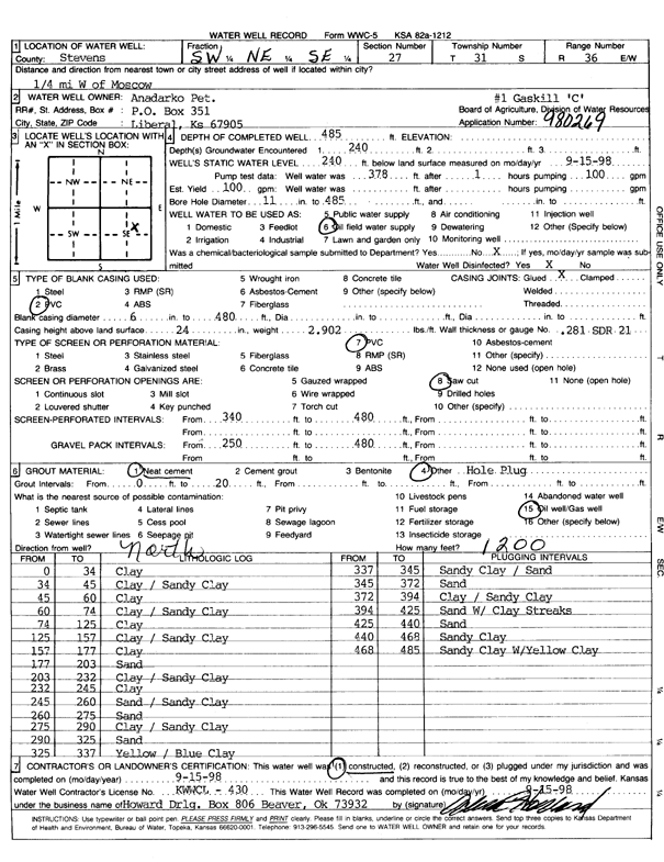
T31S, R36W, Sec. 27 SW NE SE |
Anadarko Petroleum Corp. | 485 ft. | 240 ft. | 100 gpm. | Oil Field Water Supply | Gaskill C-1 | Constructed | 15-Sep-1998 | Scan |
|
T31S, R36W, Sec. 27 NW NW NW |
Maxwell, Randy | 515 ft. | 316 ft. | Domestic | Constructed | 07-Apr-2025 |
KOLAR |
||
|
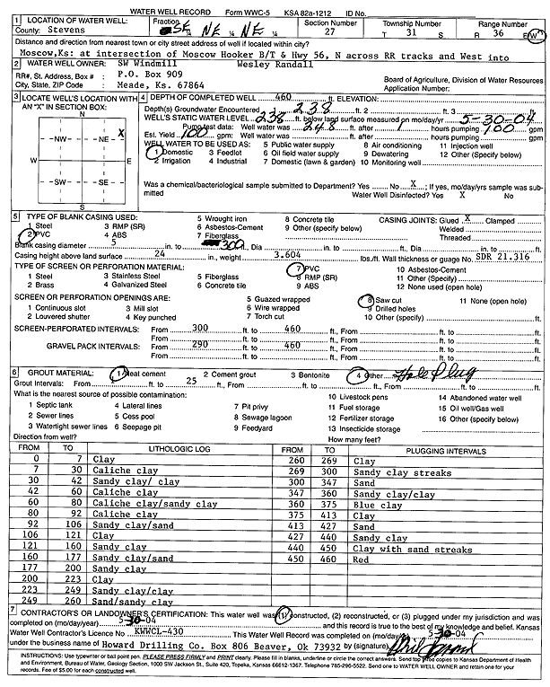
T31S, R36W, Sec. 27 SE NE NE |
SW Windmill | 460 ft. | 238 ft. | 100 gpm. | Domestic | Constructed | 30-May-2004 | Scan | |
|
T31S, R36W, Sec. 28 NW SW SW |
Bryant, David | 577 ft. | 342 ft. | Irrigation | Constructed | 15-Feb-2023 |
KOLAR |
||
|
T31S, R36W, Sec. 28 SW NW NE |
Rosson, Mrs. Keith | 430 ft. | 171 ft. | 1300 gpm. | Irrigation | Constructed | 23-Nov-1977 | ||
|
T31S, R36W, Sec. 29 SW SW NE |
Rosson, Mrs. Keith | 534 ft. | 170 ft. | 2000 gpm. | Irrigation | Constructed | 23-Nov-1977 | ||
|
T31S, R36W, Sec. 31 SE SE NE |
Munson, Steve | 520 ft. | 305 ft. | 80 gpm. | Domestic | Constructed | 03-Dec-2010 | ||
|
T31S, R36W, Sec. 32 SW SW NE |
Teeter, Ross | 567 ft. | 170 ft. | Irrigation | Constructed | 30-Jun-1977 | |||
|
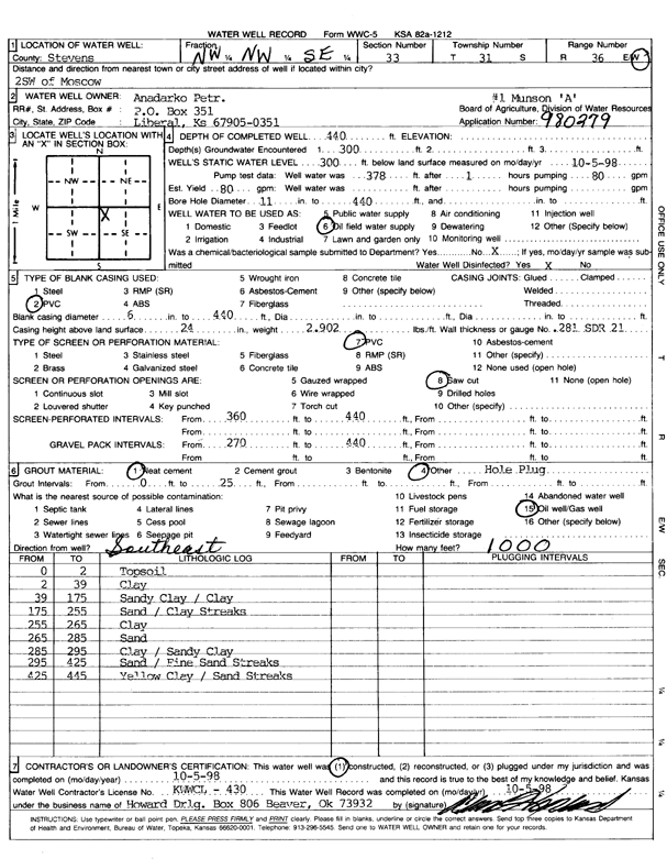
T31S, R36W, Sec. 33 NW NW SE |
Anadarko Petroleum Corp. | 440 ft. | 300 ft. | 80 gpm. | Oil Field Water Supply | Munson A-1 | Constructed | 05-Oct-1998 | Scan |
|
T31S, R36W, Sec. 33 SE SE SE |
Davis Irrigation | 397 ft. | 205 ft. | 40 gpm. | Domestic | Constructed | 05-Jun-1984 | ||
|
T31S, R36W, Sec. 33 SE SW NE |
Dudley Estate | 577 ft. | 235 ft. | Irrigation | Constructed | 17-Mar-1993 | |||
|
T31S, R36W, Sec. 33 NW SE SW NE |
Ellsaessar, Jeremy | 431 ft. | 340 ft. | Irrigation | Plugged | 13-Feb-2020 |
KOLAR |
||
| View page: 1 || 2 || 3 || 4 || 5 || 6 || 7 || 8 || 9 || 10 || Next > | |||||||||