Select location of well to view details.
Click on column heading to sort.
|
|
|
County: Thomas Select location of well to view details. Click on column heading to sort. |
|
|
|
| View page: < Prev || 21 || 22 || 23 || 24 || 25 || 26 || 27 || 28 || 29 || 30 || Next > | |||||||||
| T-R-S | Owner | Well Depth Ascend. Desc. |
Static Water Level Ascend. Desc. |
Est. Yield Ascend. Desc. |
Well Use | Other ID | Action Taken | Completion Date Ascend. Desc. |
Scan? |
|
T8S, R33W, Sec. 4 SW NE NW |
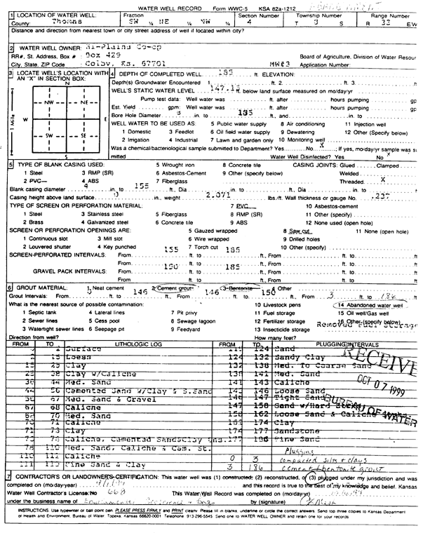
Hi-Plains Co-op | 185 ft. | 147.15 ft. | Monitoring well/observation/piezometer | MW 3 | Constructed | 20-Oct-1996 | ||
|
T8S, R33W, Sec. 4 SW NE NW |
Hi-Plains Co-op | 185 ft. | 147.15 ft. | Monitoring well/observation/piezometer | MW 3 | Plugged | 01-Sep-1999 | Scan | |
|
T8S, R33W, Sec. 4 SW NE NW |
Hi-Plains Co-op | 165 ft. | 147.83 ft. | Monitoring well/observation/piezometer | MW 6 | Plugged | 01-Sep-1999 | Scan | |
|
T8S, R33W, Sec. 4 SW NE NW |
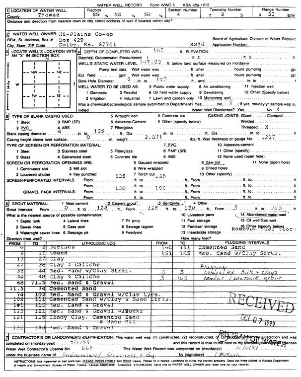
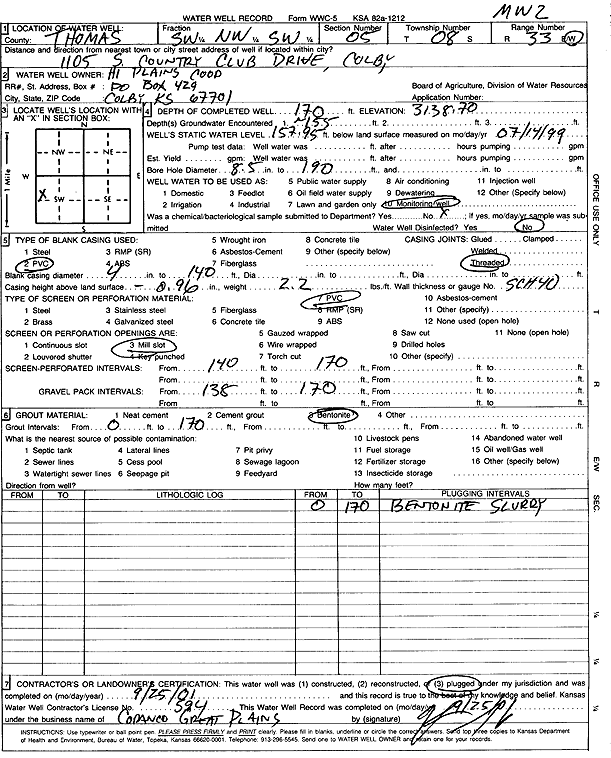
Hi-Plains Co-op | 160 ft. | 145.35 ft. | Monitoring well/observation/piezometer | MW 2 | Plugged | 01-Sep-1999 | Scan | |
|
T8S, R33W, Sec. 4 SW NE NW |
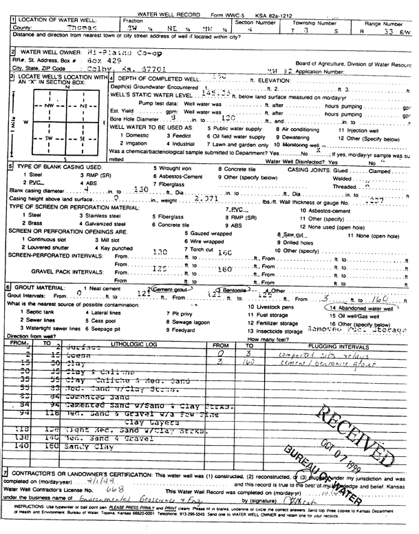
Hi-Plains Co-op | 170 ft. | 146.98 ft. | Monitoring well/observation/piezometer | MW 1 | Constructed | 18-Oct-1996 | ||
|
T8S, R33W, Sec. 4 SW NE NW |
Hi-Plains Co-op | 165 ft. | 147.63 ft. | Monitoring well/observation/piezometer | MW 4 | Constructed | 21-Oct-1996 | ||
|
T8S, R33W, Sec. 4 SW NE NW |
Hi-Plains Co-op | 160 ft. | 145.35 ft. | Monitoring well/observation/piezometer | MW 2 | Constructed | 22-Oct-1996 | ||
|
T8S, R33W, Sec. 4 SW NE NW |
Hi-Plains Co-op | 165 ft. | 146.97 ft. | Monitoring well/observation/piezometer | MW 5 | Constructed | 21-Oct-1996 | ||
|
T8S, R33W, Sec. 4 SW NE NW |
Hi-Plains Co-op | 165 ft. | 147.25 ft. | Monitoring well/observation/piezometer | MW 7 | Constructed | 22-Oct-1996 | ||
|
T8S, R33W, Sec. 4 NW NW NW |
John Deere Imp | 255 ft. | 151 ft. | Domestic | Constructed | 07-Oct-1993 | |||
|
T8S, R33W, Sec. 4 SW SW NW NW |
KDHE | 183 ft. | 158 ft. | Monitoring well/observation/piezometer | MW-19S | Constructed | 18-Feb-2014 |
KOLAR |
|
|
T8S, R33W, Sec. 4 SW SW NW NW |
KDHE | 225 ft. | 157 ft. | 250 gpm. | Monitoring well/observation/piezometer | MW-19I | Constructed | 19-Feb-2014 |
KOLAR |
|
T8S, R33W, Sec. 4 NW NW NW |
Lane Implement | 278 ft. | 110 ft. | Domestic | Constructed | 16-Nov-1976 | |||
|
T8S, R33W, Sec. 4 SW SW NE |
Thomas County Landfill | 170 ft. | 146.58 ft. | Monitoring well/observation/piezometer | Constructed | 16-Mar-1995 | |||
|
T8S, R33W, Sec. 4 NE SE NE |
Thomas County Landfill | 212 ft. | 193.25 ft. | Monitoring well/observation/piezometer | MW 5R | Constructed | 16-Sep-2008 | ||
|
T8S, R33W, Sec. 4 NE SE NE |
Thomas County Landfill | 181.5 ft. | 156.27 ft. | 10 gpm. | Monitoring well/observation/piezometer | MW 7 | Constructed | 13-Apr-2006 | |
|
T8S, R33W, Sec. 4 SE SE SE NE |
Thomas County Landfill | 215 ft. | 195.25 ft. | Monitoring well/observation/piezometer | MW 3R | Constructed | 16-Apr-2019 | ||
|
T8S, R33W, Sec. 4 SW SE SE |
Thomas County Landfill | 260 ft. | Domestic | Constructed | 02-Nov-2007 | ||||
|
T8S, R33W, Sec. 4 SE SE NE |
Thomas County Landfill | 186 ft. | 174.96 ft. | Monitoring well/observation/piezometer | MW 4 | Constructed | 31-Aug-1994 | ||
|
T8S, R33W, Sec. 4 NE SE NE |
Thomas County Landfill | 217 ft. | 190.48 ft. | Monitoring well/observation/piezometer | MW 4R | Constructed | 17-Sep-2008 | ||
|
T8S, R33W, Sec. 4 NE NE SE |
Thomas County Landfill | 258 ft. | Industrial | Constructed | 13-Jul-2006 | ||||
|
T8S, R33W, Sec. 4 NE SE NE |
Thomas County Landfill | 192 ft. | 162.13 ft. | 20 gpm. | Monitoring well/observation/piezometer | MW 8 | Constructed | 13-Apr-2006 | |
|
T8S, R33W, Sec. 4 SE SE NE |
Thomas County Landfill | 187 ft. | 176.13 ft. | Monitoring well/observation/piezometer | MW 5 | Constructed | 01-Sep-1994 | ||
|
T8S, R33W, Sec. 5 SW SE SW |
Belshe, Claude | 240 ft. | 106 ft. | Domestic | Constructed | 28-Oct-1976 | |||
|
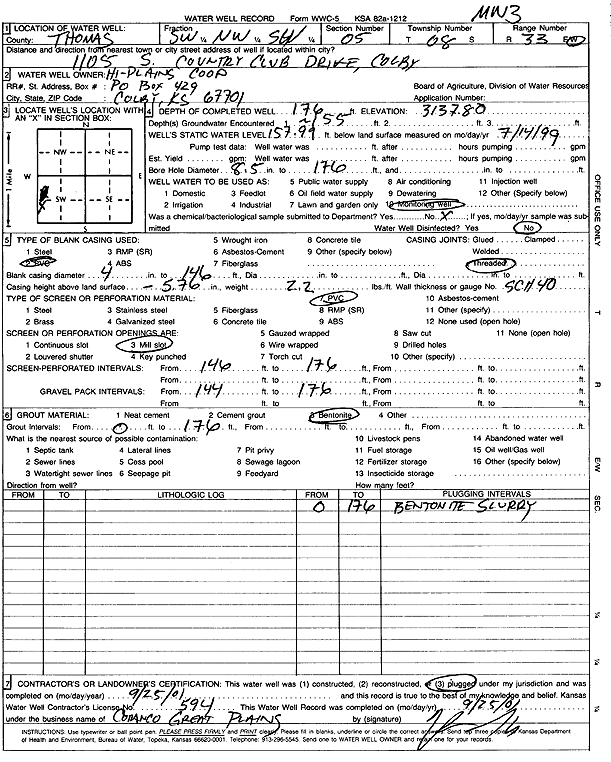
T8S, R33W, Sec. 5 SW NW SW |
Hi Plains Coop | 170 ft. | 157.95 ft. | Monitoring well/observation/piezometer | MW 2 | Constructed | 02-Jul-1999 | Scan | |
|
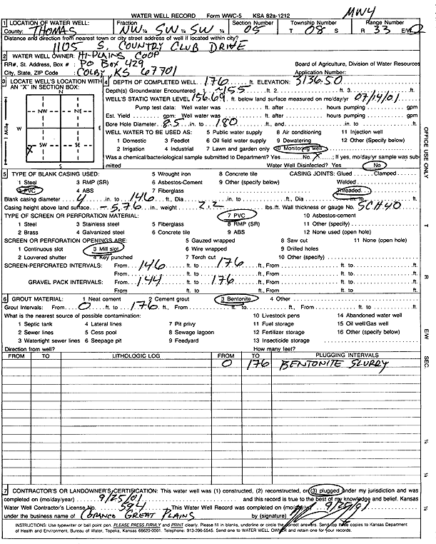
T8S, R33W, Sec. 5 NW SW SW |
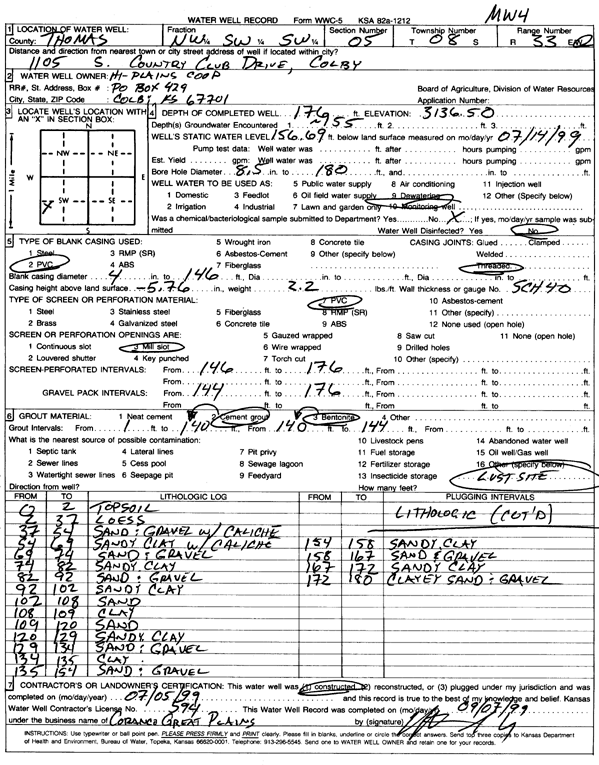
Hi Plains Coop | 176 ft. | 156.7 ft. | Monitoring well/observation/piezometer | MW 4 | Plugged | 25-Sep-2001 | Scan | |
|
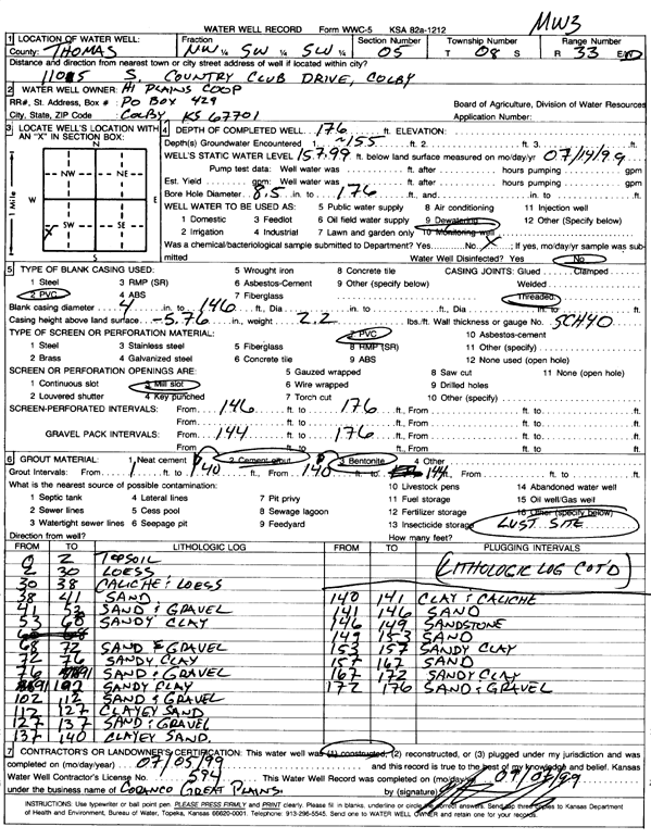
T8S, R33W, Sec. 5 NW SW SW |
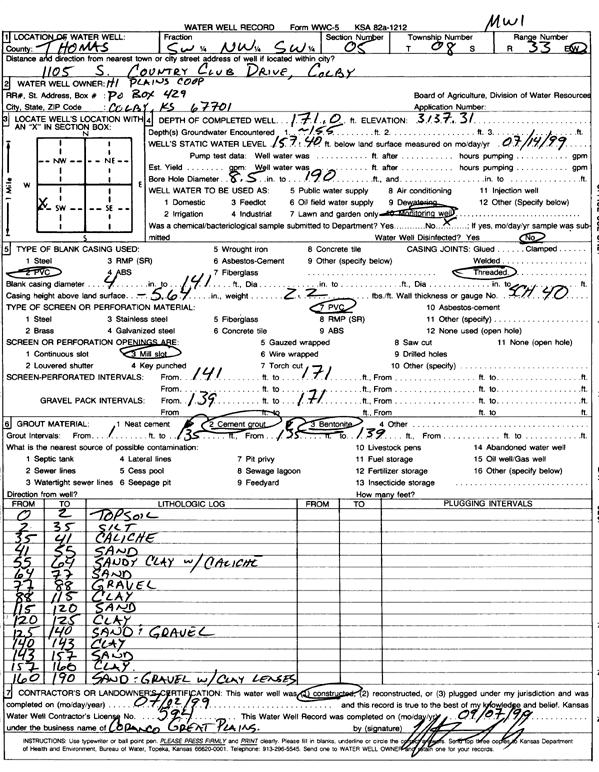
Hi Plains Coop | 176 ft. | 157.99 ft. | Monitoring well/observation/piezometer | MW 3 | Constructed | 05-Jul-1999 | Scan | |
|
T8S, R33W, Sec. 5 SW NW SW |
Hi Plains Coop | 176 ft. | 157.99 ft. | Monitoring well/observation/piezometer | MW 3 | Plugged | 25-Sep-2001 | Scan | |
|
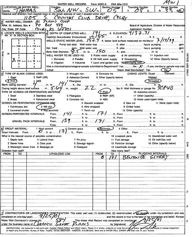
T8S, R33W, Sec. 5 SW NW SW |
Hi Plains Coop | 171 ft. | 157.4 ft. | Monitoring well/observation/piezometer | MW 1 | Plugged | 25-Sep-2001 | Scan | |
|
T8S, R33W, Sec. 5 SW NW SW |
Hi Plains Coop | 170 ft. | 157.95 ft. | Monitoring well/observation/piezometer | MW 2 | Plugged | 25-Sep-2001 | Scan | |
|
T8S, R33W, Sec. 5 NW SW SW |
Hi Plains Coop | 176 ft. | 156.69 ft. | Monitoring well/observation/piezometer | MW 4 | Constructed | 05-Jul-1999 | Scan | |
|
T8S, R33W, Sec. 5 SW NW SW |
Hi Plains Coop | 171 ft. | 157.4 ft. | Monitoring well/observation/piezometer | MW 1 | Constructed | 02-Jul-1999 | Scan | |
|
T8S, R33W, Sec. 5 NW NE NW |
Landry, Francis | Domestic | Plugged | 30-May-1988 | |||||
|
T8S, R33W, Sec. 5 NW NW NW NE |
Metzler Trust | 124 ft. | Domestic | Plugged | 27-Apr-2017 | ||||
|
T8S, R33W, Sec. 5 SW SE NE |
Rietcheck, Daniel and Megan | 270 ft. | 190 ft. | 40 gpm. | Domestic | Constructed | 15-Jun-2023 |
KOLAR |
|
|
T8S, R33W, Sec. 5 NE NW NE |
Sowers, Byron | 105 ft. | 80 ft. | Domestic | Plugged | 30-Dec-1988 | |||
|
T8S, R33W, Sec. 5 SE SW SW |
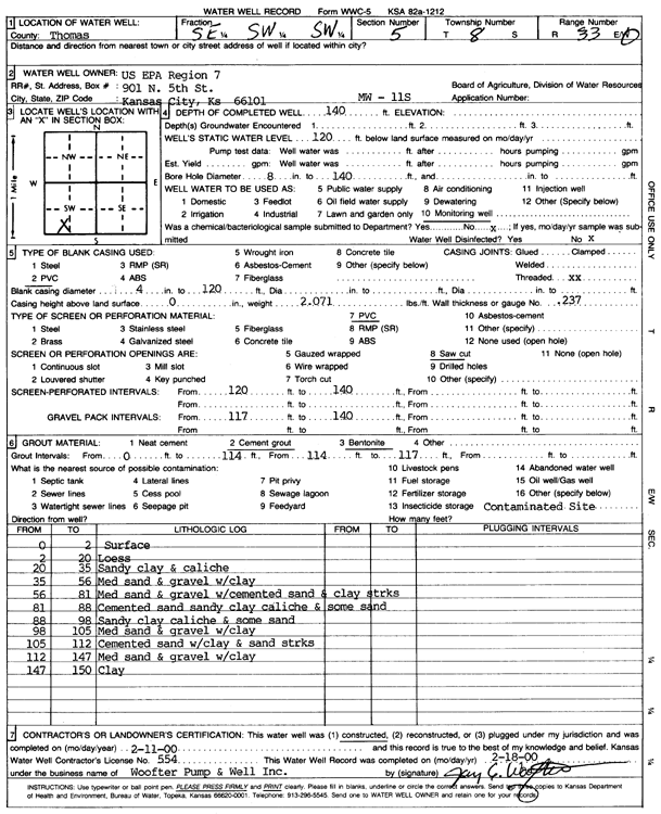
U.S. EPA Region 7 | 140 ft. | 120 ft. | Monitoring well/observation/piezometer | MW 11 S | Constructed | 11-Feb-2000 | Scan | |
|
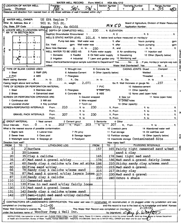
T8S, R33W, Sec. 5 NE SW SW |
U.S. EPA Region 7 | 230 ft. | 101.4 ft. | Monitoring well/observation/piezometer | MW 5 D | Constructed | 11-Feb-2000 | Scan | |
|
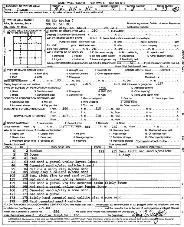
T8S, R33W, Sec. 5 NW NW NE |
U.S. EPA Region 7 | 210 ft. | 143.2 ft. | Monitoring well/observation/piezometer | MW 12 I | Constructed | 09-Feb-2000 | Scan | |
|
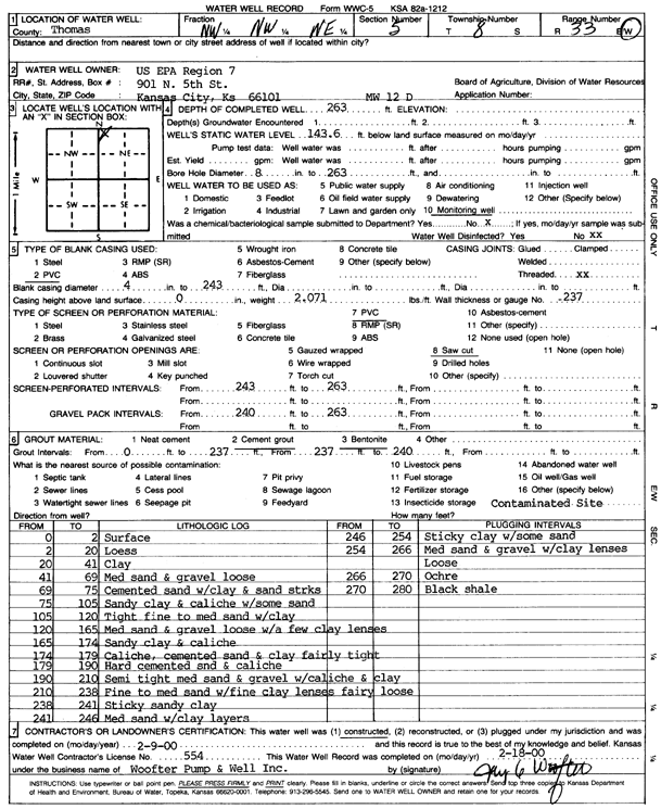
T8S, R33W, Sec. 5 NW NW NE |
U.S. EPA Region 7 | 263 ft. | 143.6 ft. | Monitoring well/observation/piezometer | MW 12 D | Constructed | 09-Feb-2000 | Scan | |
|
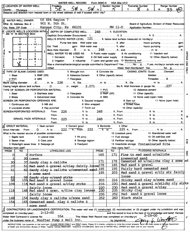
T8S, R33W, Sec. 5 SE SW SW |
U.S. EPA Region 7 | 248 ft. | 121 ft. | Monitoring well/observation/piezometer | MW 11 D | Constructed | 12-Feb-2000 | Scan | |
|
T8S, R33W, Sec. 5 NW NW NE NW |
U.S. EPA Region 7 | 142 ft. | Monitoring well/observation/piezometer | MW 13 S | Plugged | 25-Feb-2014 |
KOLAR |
||
|
T8S, R33W, Sec. 5 SW SW NE NW |
U.S. EPA Region 7 | 156 ft. | 147 ft. | Monitoring well/observation/piezometer | MW 16 S | Plugged | 18-Feb-2014 |
KOLAR |
|
|
T8S, R33W, Sec. 5 NE SE NE NW |
U.S. EPA Region 7 | 261 ft. | 155 ft. | Monitoring well/observation/piezometer | MW 17 D | Plugged | 25-Feb-2014 |
KOLAR |
|
|
T8S, R33W, Sec. 5 NE SE NE NW |
U.S. EPA Region 7 | 204 ft. | 155 ft. | Monitoring well/observation/piezometer | MW 17 I | Plugged | 25-Feb-2014 |
KOLAR |
|
|
T8S, R33W, Sec. 5 NE SE NE NW |
U.S. EPA Region 7 | 157 ft. | 155 ft. | Monitoring well/observation/piezometer | MW 17 S | Plugged | 25-Feb-2014 |
KOLAR |
|
|
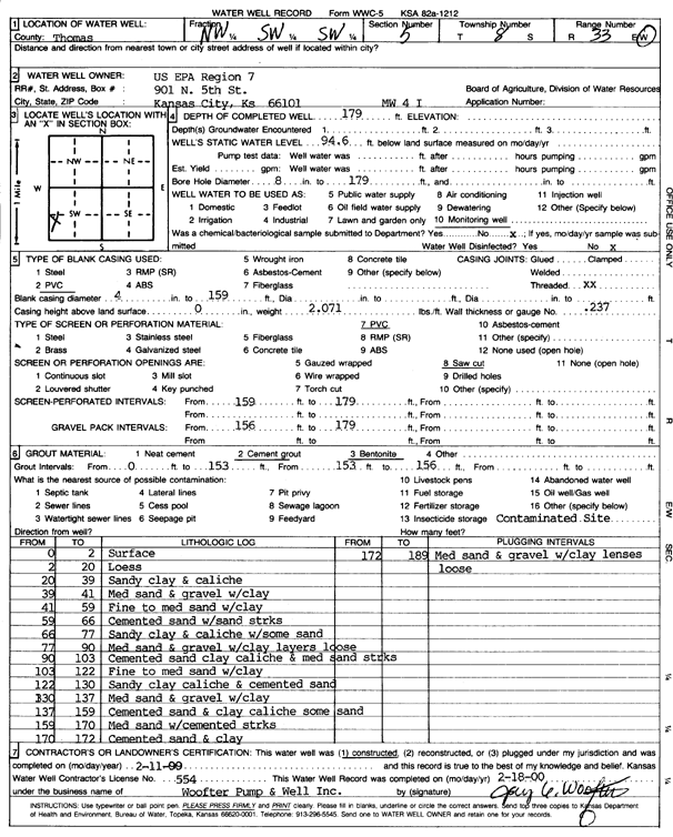
T8S, R33W, Sec. 5 NW SW SW |
U.S. EPA Region 7 | 179 ft. | 94.6 ft. | Monitoring well/observation/piezometer | MW 4 I | Constructed | 11-Feb-2000 | Scan | |
|
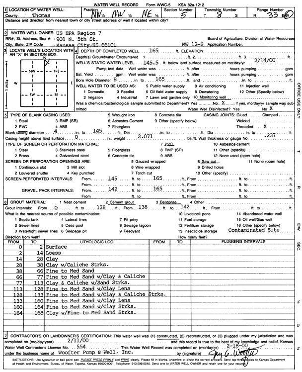
T8S, R33W, Sec. 5 NW NW NE |
U.S. EPA Region 7 | 165 ft. | 145.5 ft. | Monitoring well/observation/piezometer | MW 12 S | Constructed | 11-Feb-2000 | Scan | |
|
T8S, R33W, Sec. 5 SW SW NE NW |
U.S. EPA Region 7 | 211 ft. | 147 ft. | Monitoring well/observation/piezometer | MW 16 I | Plugged | 25-Feb-2014 |
KOLAR |
|
|
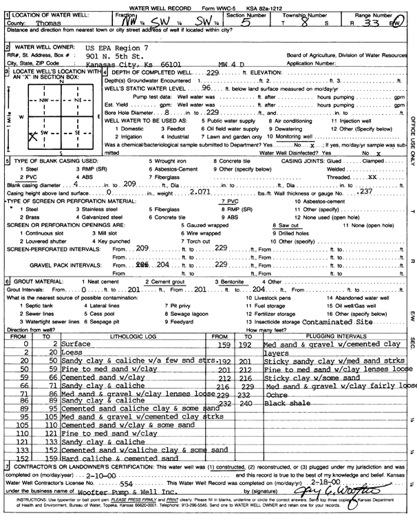
T8S, R33W, Sec. 5 NW SW SW |
U.S. EPA Region 7 | 229 ft. | 96 ft. | Monitoring well/observation/piezometer | MW 4 D | Constructed | 10-Feb-2000 | Scan | |
| View page: < Prev || 21 || 22 || 23 || 24 || 25 || 26 || 27 || 28 || 29 || 30 || Next > | |||||||||