Select location of well to view details.
Click on column heading to sort.
|
|
|
County: Douglas Select location of well to view details. Click on column heading to sort. |
|
|
|
| View page: < Prev || 41 || 42 || 43 || 44 || 45 || 46 || 47 || 48 || 49 || 50 || Next > | |||||||||
| T-R-S | Owner | Well Depth Ascend. Desc. |
Static Water Level Ascend. Desc. |
Est. Yield Ascend. Desc. |
Well Use | Other ID | Action Taken | Completion Date Ascend. Desc. |
Scan? |
|
T14S, R17E, Sec. 36 SE SE SE |
City of Overbrook | 500 ft. | 348 ft. | 30 gpm. | Public Water Supply | Well 5 | Constructed | 20-May-1980 | Scan |
|
T14S, R17E, Sec. 36 NW NW SE |
City of Overbrook | 493 ft. | 318 ft. | 60 gpm. | Public Water Supply | Well 4 | Constructed | 18-Apr-1979 | Scan |
|
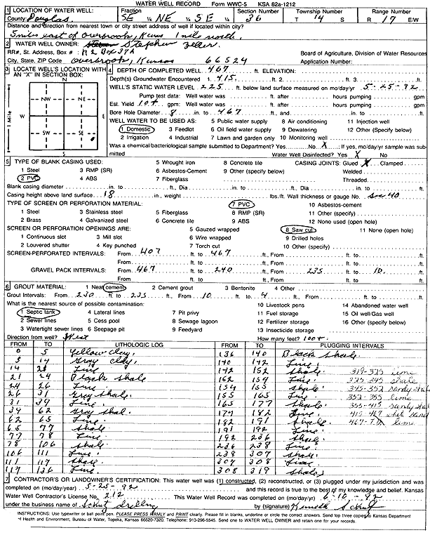
T14S, R17E, Sec. 36 SE NE SE |
Zeller, Stephen | 467 ft. | 225 ft. | 10 gpm. | Domestic | Constructed | 25-May-1992 | Scan | |
|
T14S, R18E, Sec. 1 NE SE NW |
Bigger, Jim | 94 ft. | 6 ft. | 6 gpm. | Domestic | Constructed | 06-Apr-1982 | ||
|
T14S, R18E, Sec. 1 NE NE SE |
Born, Larry | 250 ft. | 113 ft. | 10 gpm. | Public Water Supply | Constructed | 28-Jul-2011 | ||
|
T14S, R18E, Sec. 1 SE NE NE |
Lone Star Church of Brethren | 20 ft. | 8 ft. | (unstated)/abandoned | Plugged | 18-Aug-2001 | |||
|
T14S, R18E, Sec. 1 NE |
Rawlings, Richard | 10 ft. | Other | Plugged | 12-Dec-2006 | ||||
|
T14S, R18E, Sec. 1 SW NE NE |
Young, Bryan | 180 ft. | Heat Pump (Closed Loop/Disposal), Geothermal | Constructed | 21-Jul-2008 | ||||
|
T14S, R18E, Sec. 2 NE SW NW SE |
Black, Sid | 400 ft. | 133 ft. | 12 gpm. | Geothermal, Closed Loop, Vertical | Constructed | 15-Feb-2016 | ||
|
T14S, R18E, Sec. 2 NE SW NW SE |
Black, Sid | 300 ft. | 133 ft. | 12 gpm. | Domestic | Constructed | 15-Feb-2016 | ||
|
T14S, R18E, Sec. 3 SW SW NW |
Campbell, Ralph | 380 ft. | 240 ft. | 5 gpm. | Domestic | Constructed | 23-Jul-1999 | Scan | |
|
T14S, R18E, Sec. 3 NW SW NW |
Rice, Fred | 343 ft. | 168 ft. | 75 gpm. | Domestic | Constructed | 26-Mar-2004 | Scan | |
|
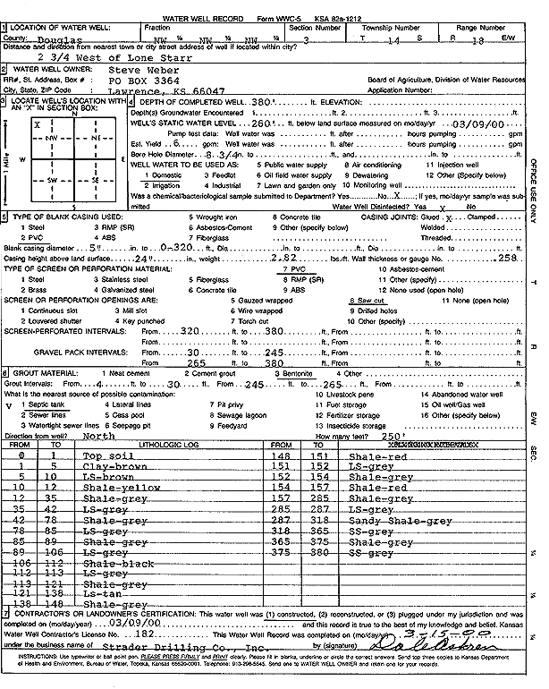
T14S, R18E, Sec. 3 NW NW NW |
Weber, Steve | 380 ft. | 260 ft. | Domestic | Constructed | 09-Mar-2000 | Scan | ||
|
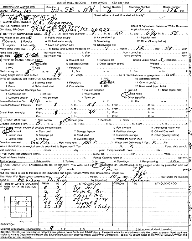
T14S, R18E, Sec. 6 NW SE NW |
Hegeman, K.R. | 58 ft. | 8 ft. | .08 gpm. | Domestic | Constructed | 12-Jul-1979 | Scan | |
|
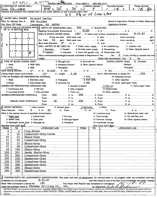
T14S, R18E, Sec. 7 NW SE SE |
Zarley, Richard | 300 ft. | 160 ft. | 15 gpm. | Domestic | Constructed | 31-Aug-1987 | Scan | |
|
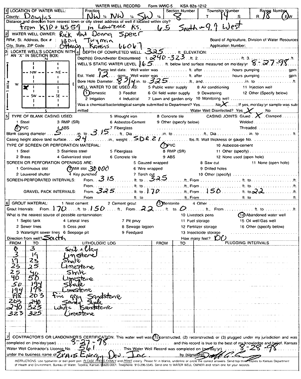
T14S, R18E, Sec. 8 NW NW SW |
Speer, Rick and Donna | 325 ft. | 165 ft. | 12 gpm. | Domestic | Constructed | 27-Aug-1998 | Scan | |
|
T14S, R18E, Sec. 9 SW NE SE NW |
Hunter, Virginia | 195 ft. | Geothermal, Closed Loop, Vertical | Constructed | 25-Oct-2021 |
KOLAR |
|||
|
T14S, R18E, Sec. 9 SW NW SW SE |
Voight | 200 ft. | Geothermal, Closed Loop, Vertical | Constructed | 11-May-2020 |
KOLAR |
|||
|
T14S, R18E, Sec. 10 NE SW NE |
Freeman, Dean | 385 ft. | 332 ft. | 20 gpm. | Domestic | Constructed | 08-Jun-2001 | Scan | |
|
T14S, R18E, Sec. 10 NW SW NE |
Freeman, Dean | 380 ft. | 275 ft. | 8 gpm. | Domestic | Constructed | 20-Aug-1998 | Scan | |
|
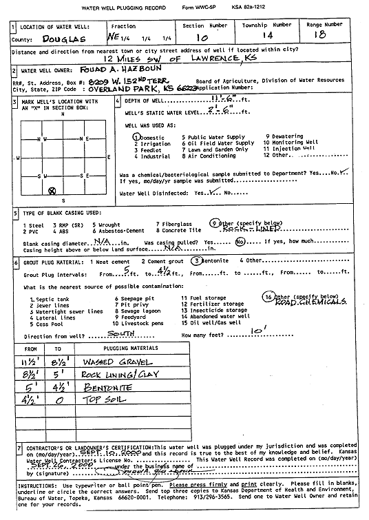
T14S, R18E, Sec. 10 SW SE SW |
Hazboun, Fouad A. | 11.5 ft. | 2.5 ft. | Domestic | Plugged | 10-Sep-2000 | Scan | ||
|
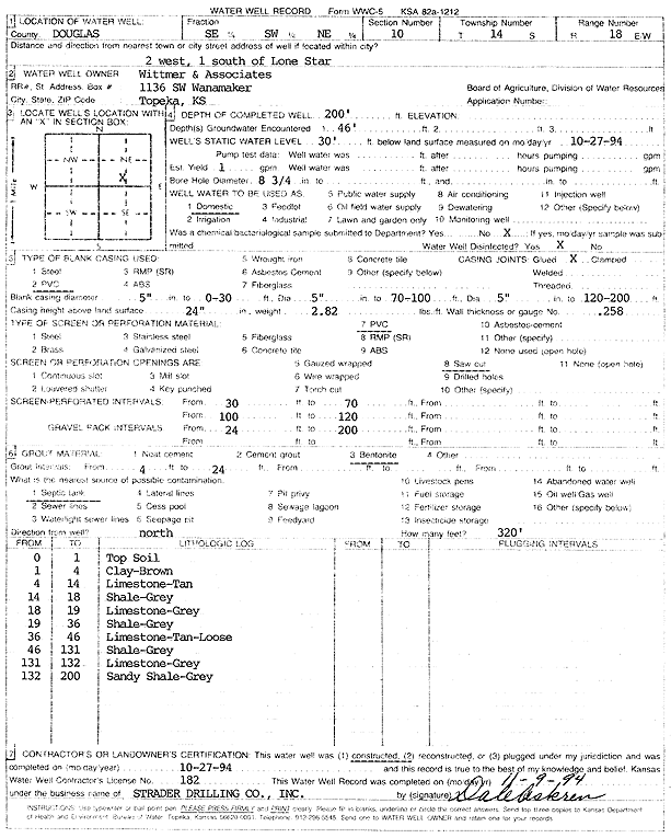
T14S, R18E, Sec. 10 SE SW NE |
Wittmer and Associates | 200 ft. | 30 ft. | 1 gpm. | Domestic | Constructed | 27-Oct-1994 | Scan | |
|
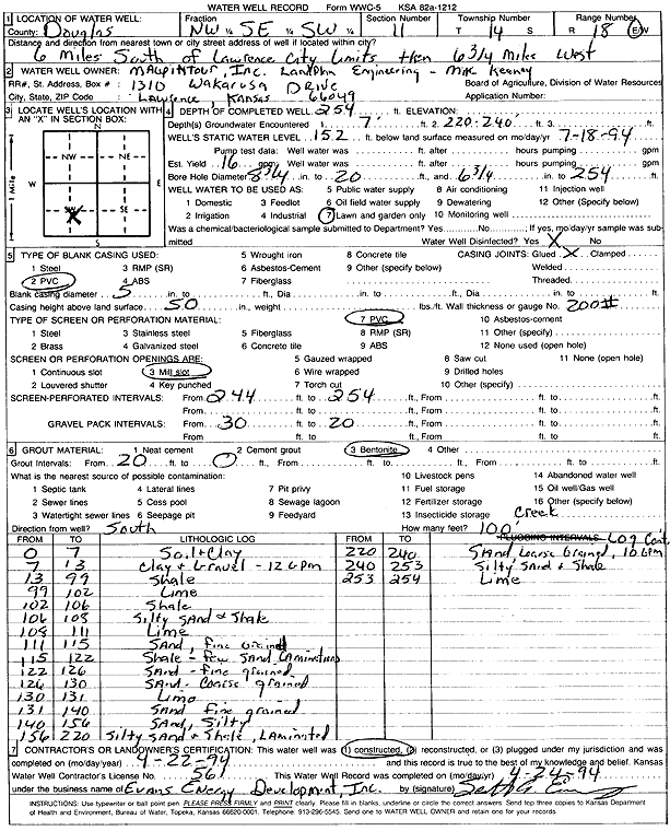
T14S, R18E, Sec. 11 NW SE SW |
Maupintour Inc. | 254 ft. | 152 ft. | 16 gpm. | Domestic, Lawn and Garden | Constructed | 22-Apr-1994 | Scan | |
|
T14S, R18E, Sec. 12 NE |
Hack, Richard | (unstated)/abandoned | Plugged | 01-Feb-2005 | |||||
|
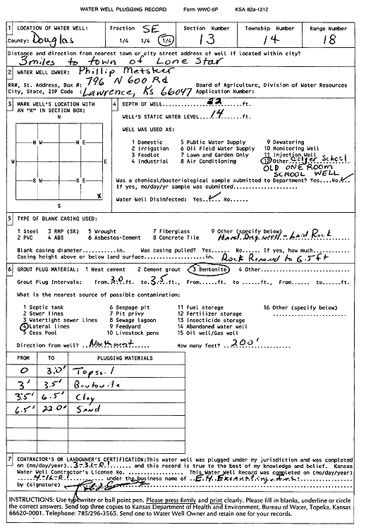
T14S, R18E, Sec. 13 SE |
Matsker, Phillip | 22 ft. | 14 ft. | Other | Plugged | 31-Mar-2001 | Scan | ||
|
T14S, R18E, Sec. 13 NW SW SW |
342 ft. | 200 ft. | 12 gpm. | Domestic | Constructed | 29-Aug-1975 | |||
|
T14S, R18E, Sec. 14 NE NW NE |
Douglas County/CCC Camp, Lone Star Lake | 368 ft. | Domestic | Plugged | 31-Jan-1994 | Scan | |||
|
T14S, R18E, Sec. 14 SW SW |
160 ft. | 60 ft. | 2 gpm. | Domestic | Constructed | 01-Jul-1980 | |||
|
T14S, R18E, Sec. 15 SE SW |
Voigt, Chad | 180 ft. | Heat Pump (Closed Loop/Disposal), Geothermal | Constructed | 10-Jun-2010 | ||||
|
T14S, R18E, Sec. 16 SW SW SW |
Gordon, John | 258 ft. | 150 ft. | 2 gpm. | Domestic | Constructed | 02-Apr-1978 | Scan | |
|
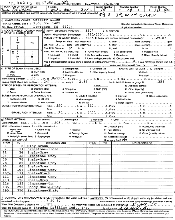
T14S, R18E, Sec. 18 NW NW SW |
Allen, Gregory | 350 ft. | 265 ft. | 3 gpm. | Domestic | Constructed | 29-Jul-1987 | Scan | |
|
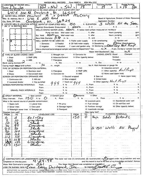
T14S, R18E, Sec. 18 NW NW SW |
McCrory, Michael A. and Geneva | 150 ft. | Heat Pump (Closed Loop/Disposal), Geothermal | Constructed | 24-Apr-1998 | Scan | |||
|
T14S, R18E, Sec. 18 SW NE SE |
Nickel, Darryl | 382 ft. | 293 ft. | 7 gpm. | Domestic | Constructed | 24-Jul-2005 | ||
|
T14S, R18E, Sec. 18 NW SE NE |
Wilson, Ron | 334 ft. | 182 ft. | 20 gpm. | Domestic | Constructed | 15-May-2008 | ||
|
T14S, R18E, Sec. 19 NE SE SE |
Douglas County | 12 ft. | 7 ft. | Domestic | Plugged | 19-Jul-2021 | |||
|
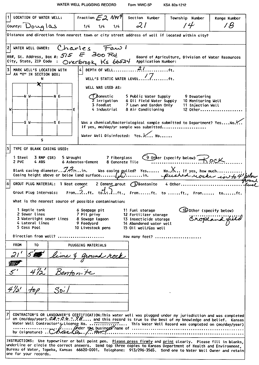
T14S, R18E, Sec. 21 E2 NW |
Fawl, Charles | 21 ft. | 17 ft. | Domestic | Plugged | 06-Mar-1998 | Scan | ||
|
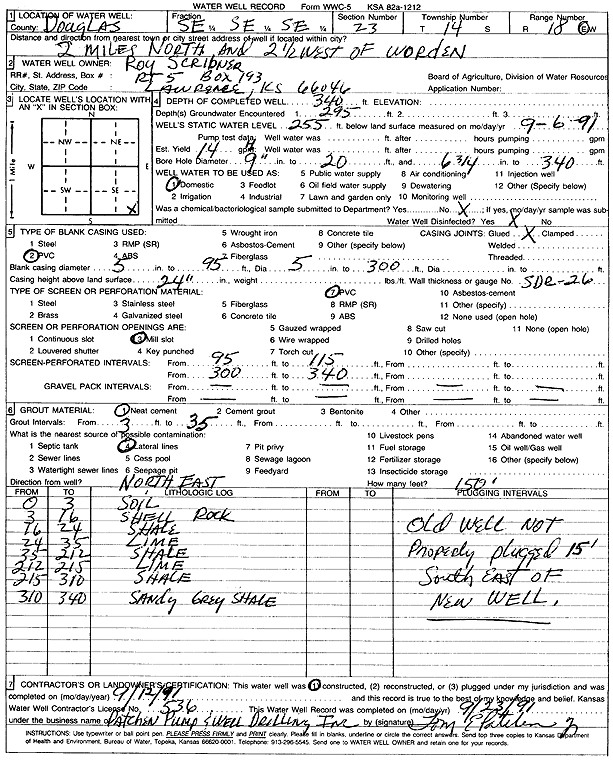
T14S, R18E, Sec. 23 SE SE SE |
Scribner, Roy | 340 ft. | 255 ft. | .23 gpm. | Domestic | Constructed | 12-Sep-1991 | Scan | |
|
T14S, R18E, Sec. 27 SE NW NE |
Howser, Mark/Groundsource, Inc | 180 ft. | Heat Pump (Closed Loop/Disposal), Geothermal | Constructed | 17-Mar-2010 | ||||
|
T14S, R18E, Sec. 28 NW NW NW |
Haley, Eugene | 475 ft. | 100 ft. | Domestic | Plugged | 24-Mar-1975 | Scan | ||
|
T14S, R18E, Sec. 28 NW NE NE |
Spriggs, Steve | 440 ft. | 180 ft. | 8 gpm. | Domestic | Constructed | 24-Feb-1998 | Scan | |
|
T14S, R18E, Sec. 31 SE SE SE |
Fawl, Charles | 17.5 ft. | 13.5 ft. | Domestic | Plugged | 22-Feb-2006 | |||
|
T14S, R18E, Sec. 31 SE SE NE |
Fawl, Mike | 360 ft. | 160 ft. | Domestic | Plugged | 08-Jun-2006 | |||
|
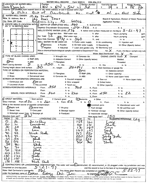
T14S, R18E, Sec. 32 NW NW SW |
Shuttic, Mike | 360 ft. | 276 ft. | Domestic | Constructed | 21-May-1997 | Scan | ||
|
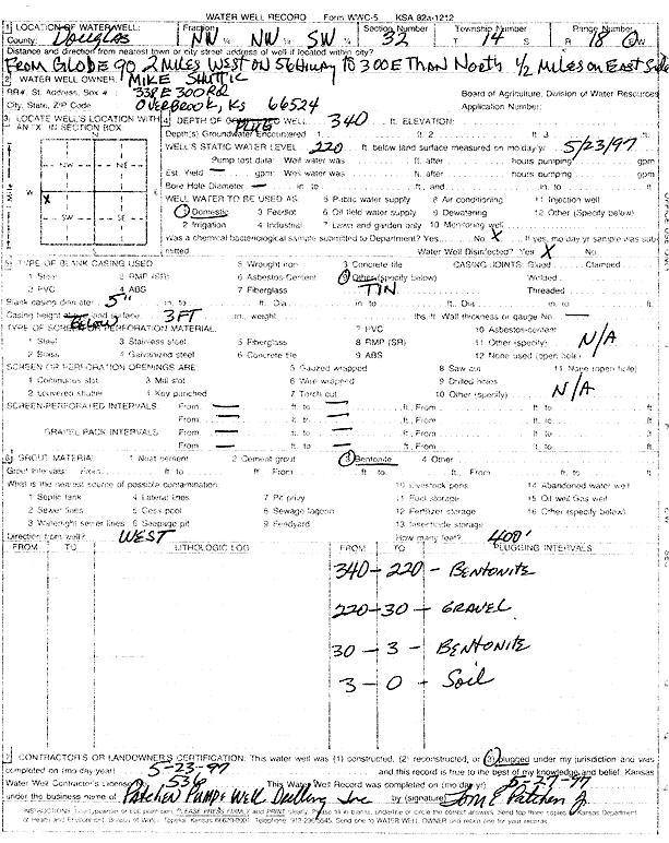
T14S, R18E, Sec. 32 NW NW SW |
Shuttic, Mike | 340 ft. | 220 ft. | Domestic | Plugged | 23-May-1997 | Scan | ||
|
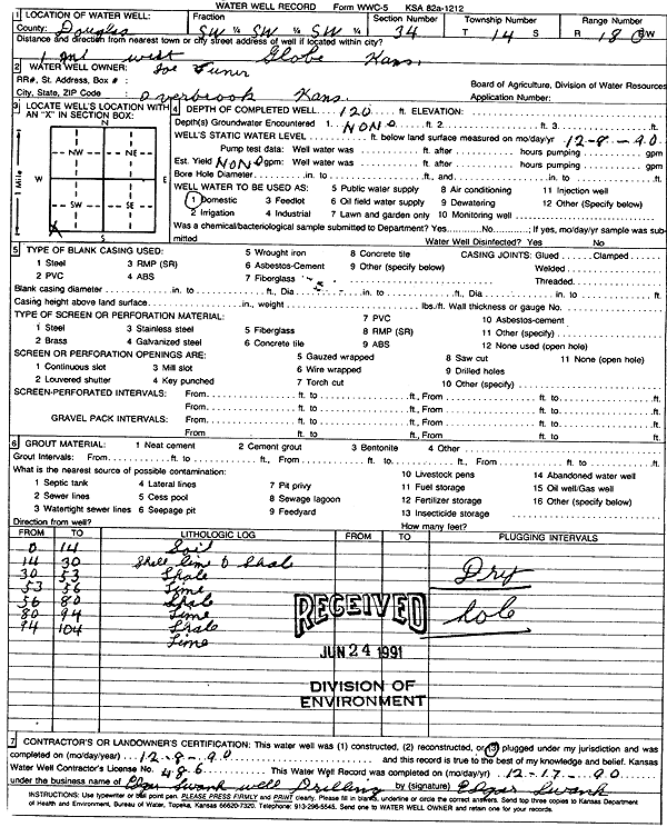
T14S, R18E, Sec. 34 SW SW SW |
Vuner, Joe | 120 ft. | Domestic | Plugged | 08-Dec-1990 | Scan | |||
|
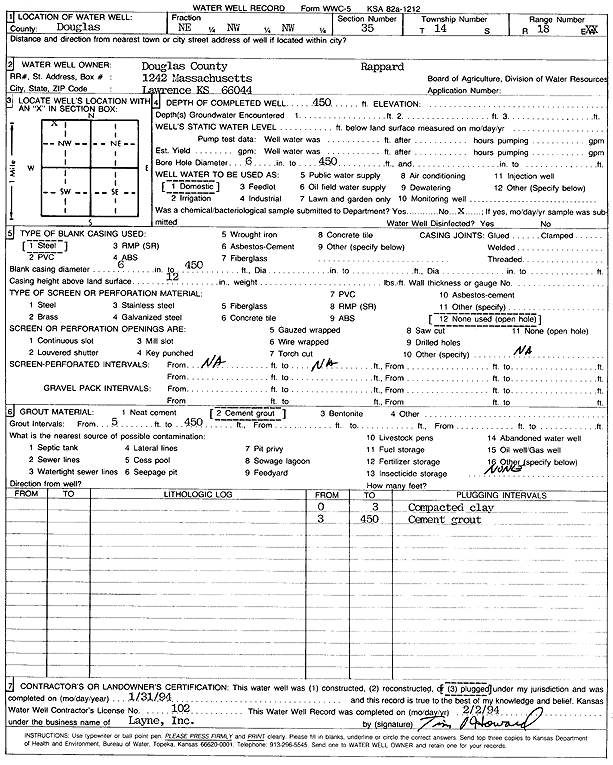
T14S, R18E, Sec. 35 NE NW NW |
Douglas County | 450 ft. | Domestic | Plugged | 31-Jan-1994 | Scan | |||
|
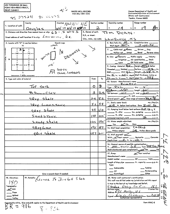
T14S, R19E, Sec. 2 NW NW NE |
Dean, Tom | 200 ft. | 104 ft. | 2 gpm. | Domestic | Constructed | 10-Feb-1976 | Scan | |
|
T14S, R19E, Sec. 2 NE SW NE |
Mott, Brian | 255 ft. | Geothermal, Closed Loop, Vertical | Constructed | 11-Feb-2026 |
KOLAR |
|||
|
T14S, R19E, Sec. 3 NW NE NE |
Gaston, Doug | 280 ft. | 170 ft. | 15 gpm. | Domestic | Constructed | 30-Aug-1996 | ||
|
T14S, R19E, Sec. 3 SE SE SW |
Hailey, Russ | 190 ft. | 98 ft. | 20 gpm. | Domestic, Lawn and Garden | Constructed | 09-Dec-2013 | ||
| View page: < Prev || 41 || 42 || 43 || 44 || 45 || 46 || 47 || 48 || 49 || 50 || Next > | |||||||||