Select location of well to view details.
Click on column heading to sort.
|
|
|
County: Finney Select location of well to view details. Click on column heading to sort. |
|
|
|
| View page: 1 || 2 || 3 || 4 || 5 || 6 || 7 || 8 || 9 || 10 || Next > | |||||||||
| T-R-S | Owner | Well Depth Ascend. Desc. |
Static Water Level Ascend. Desc. |
Est. Yield Ascend. Desc. |
Well Use | Other ID | Action Taken | Completion Date Ascend. Desc. |
Scan? |
|
T22S, R33W, Sec. 26 SW SW NE |
Meeker, Inc. | 224 ft. | 139 ft. | 1250 gpm. | Irrigation | Constructed | 12-Feb-1996 | Scan | |
|
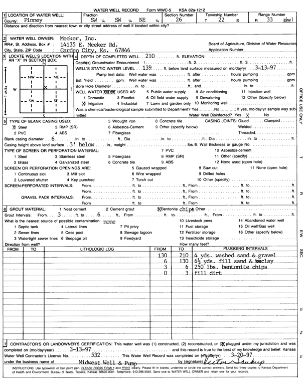
T22S, R33W, Sec. 26 SW SW NE |
Meeker, Inc. | 210 ft. | 139 ft. | Irrigation | Plugged | 13-Mar-1997 | Scan | ||
|
T22S, R33W, Sec. 27 SW SE |
Caldwell, Doug | 210 ft. | Irrigation | Constructed | 03-Jun-2015 | ||||
|
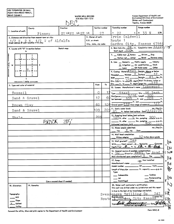
T22S, R33W, Sec. 27 SW NW SE |
Caldwell, Irvin | 209 ft. | 85 ft. | 900 gpm. | Irrigation | Constructed | 22-Dec-1975 | Scan | |
|
T22S, R33W, Sec. 27 SW NW |
Strasser, Kory | 215 ft. | Irrigation | Constructed | 04-Jun-2015 | ||||
|
T22S, R33W, Sec. 28 SW NW NE |
Damme Farms | 197 ft. | 153 ft. | 300 gpm. | Irrigation | Reconstructed | 09-Jul-2014 | ||
|
T22S, R33W, Sec. 29 SW SW NE |
Roth, Ronald | 226 ft. | 157 ft. | 420 gpm. | Irrigation | Constructed | 14-Jun-1995 | Scan | |
|
T22S, R33W, Sec. 30 SW SW SW |
Garden City, Co. | 271 ft. | 169 ft. | 700 gpm. | Irrigation | Constructed | 28-Jun-1982 | Scan | |
|
T22S, R33W, Sec. 31 NE SW SE |
Baldwin, Edward and Irene | 319 ft. | 202 ft. | 850 gpm. | Irrigation | Constructed | 25-Nov-1983 | Scan | |
|
T22S, R33W, Sec. 31 SE NE SW NE |
Blue Bottom LLC | 310 ft. | 217 ft. | 719 gpm. | Irrigation | Constructed | 10-Dec-2021 |
KOLAR |
|
|
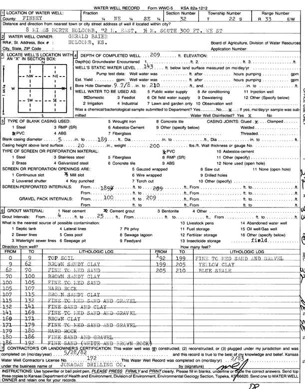
T22S, R33W, Sec. 32 NE SE |
Baier, Gerald | 209 ft. | 143 ft. | Domestic | Constructed | 28-May-1982 | Scan | ||
|
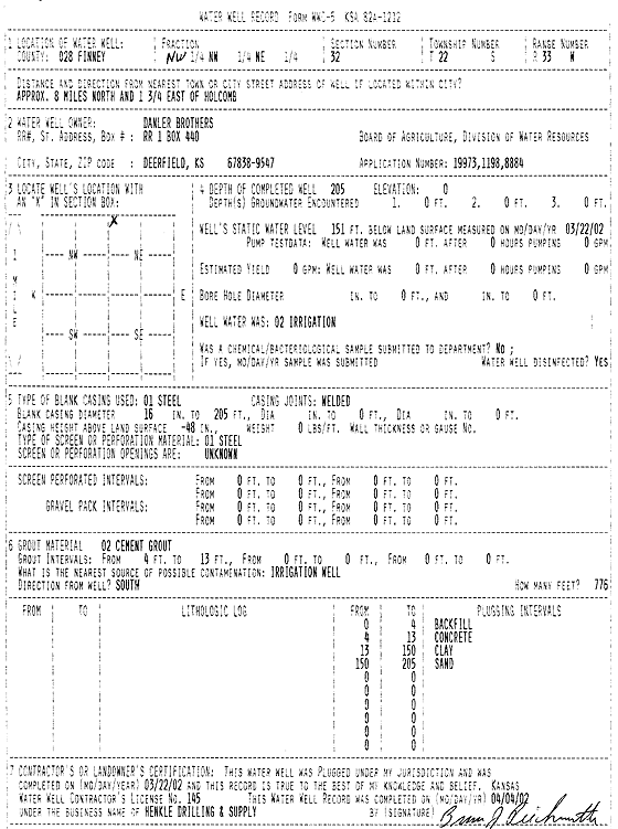
T22S, R33W, Sec. 32 SW NW NE |
Danler Brothers | 226 ft. | 148 ft. | Irrigation | Constructed | 12-Mar-2002 | Scan | ||
|
T22S, R33W, Sec. 32 NW NW NE |
Danler Brothers | 205 ft. | 151 ft. | Irrigation | Plugged | 22-Mar-2002 | Scan | ||
|
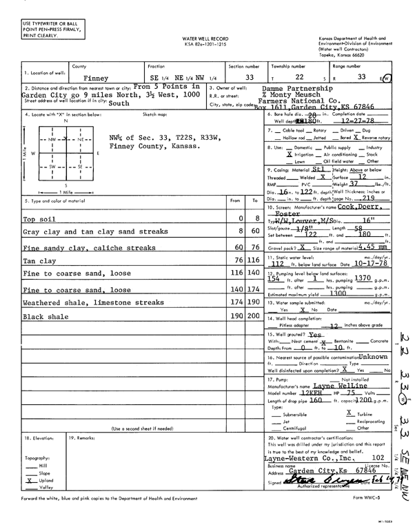
T22S, R33W, Sec. 33 SE NE NW |
Damme Partnership | 180 ft. | 112 ft. | 1300 gpm. | Irrigation | Constructed | 27-Dec-1978 | Scan | |
|
T22S, R33W, Sec. 33 NW NW NE |
Hartman Oil | 180 ft. | 172 ft. | Domestic | Plugged | 11-May-2022 |
KOLAR |
||
|
T22S, R33W, Sec. 33 NW NW NE |
Hartman Oil | 208 ft. | 172 ft. | 24 gpm. | Domestic | Constructed | 06-May-2022 |
KOLAR |
|
|
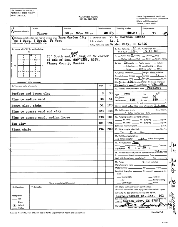
T22S, R33W, Sec. 33 NW NW NE |
W.L. Hartman Estate | 180 ft. | Domestic | Constructed | 12-May-1980 | Scan | |||
|
T22S, R33W, Sec. 34 NE NE NW |
Finnup Foundation | 200 ft. | 180 ft. | Irrigation | 3930 | Plugged | 20-Dec-2024 | ||
|
T22S, R33W, Sec. 34 NW SW NW |
Finnup Foundation | 220 ft. | 152 ft. | 650 gpm. | Irrigation | Constructed | 10-Sep-1986 | Scan | |
|
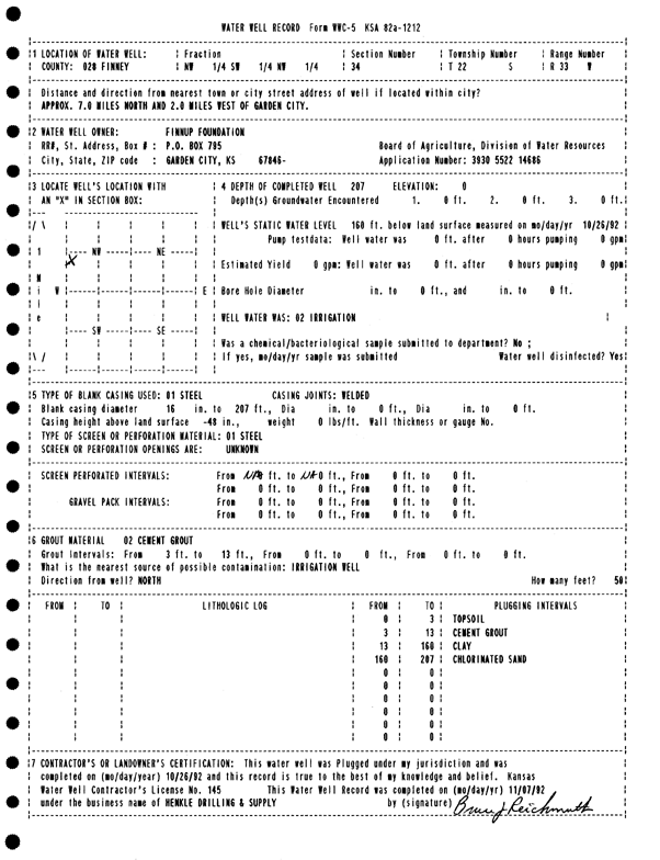
T22S, R33W, Sec. 34 NW SW NW |
Finnup Foundation | 207 ft. | 160 ft. | Irrigation | Plugged | 26-Oct-1992 | Scan | ||
|
T22S, R33W, Sec. 35 NE SE SE |
Hattendorf, Norbert | 240 ft. | 139 ft. | Irrigation | Plugged | 06-Dec-1990 | Scan | ||
|
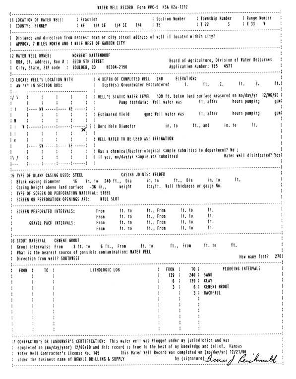
T22S, R33W, Sec. 35 NE SE SE |
Hattendorf, Norbert | 245 ft. | 139 ft. | 1200 gpm. | Irrigation | Constructed | 20-Nov-1990 | Scan | |
|
T22S, R33W, Sec. 35 SW SW SW |
Holsted, Greg | 228 ft. | 188 ft. | Domestic | Constructed | 15-Dec-2004 | |||
|
T22S, R33W, Sec. 35 SE SW NW |
Knoll, Don | 242 ft. | 161 ft. | 230 gpm. | Irrigation | Constructed | 07-Dec-2023 |
KOLAR |
|
|
T22S, R33W, Sec. 35 SE SW NW |
Knoll, Don | 243 ft. | 164 ft. | Irrigation | Plugged | 03-Mar-2025 |
KOLAR |
||
|
T22S, R33W, Sec. 35 SE SW NW |
Knoll, Don | 235 ft. | 168 ft. | Irrigation | Constructed | 20-Jun-2025 |
KOLAR |
||
|
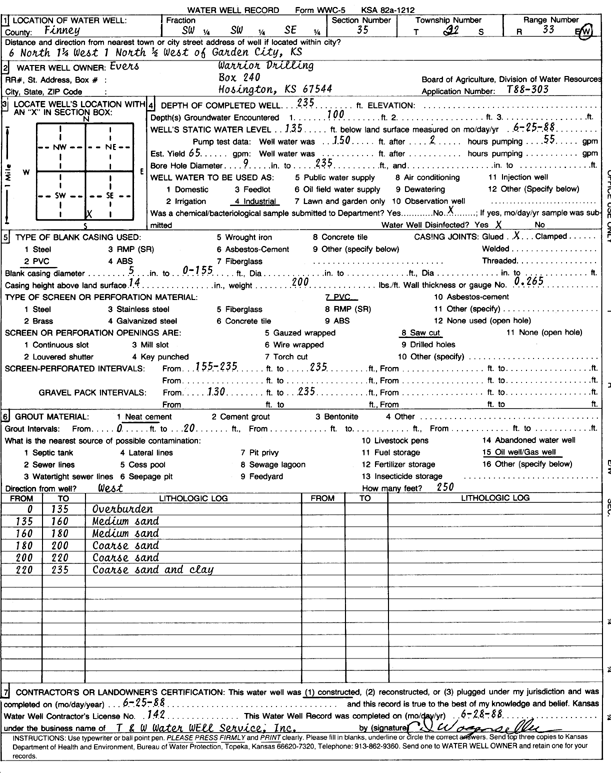
T22S, R33W, Sec. 35 SW SW SE |
Warrior Drilling | 235 ft. | 135 ft. | 65 gpm. | Oil Field Water Supply | Constructed | 25-Jun-1988 | Scan | |
|
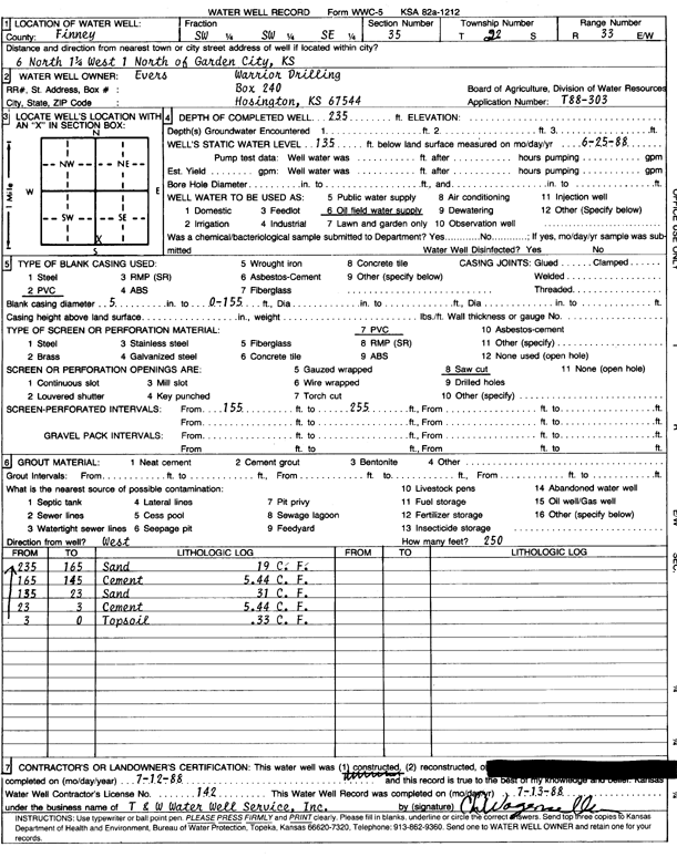
T22S, R33W, Sec. 35 SW SW SE |
Warrior Drilling | 235 ft. | 135 ft. | Oil Field Water Supply | Plugged | 12-Jul-1988 | Scan | ||
|
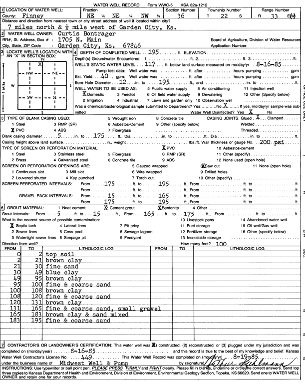
T22S, R33W, Sec. 36 NE NE NW |
Bontrager, Curtis | 195 ft. | 117 ft. | 40 gpm. | Domestic | Constructed | 16-Aug-1985 | Scan | |
|
T22S, R33W, Sec. 36 SE SW SW SE |
Carillo, Geronimo | 220 ft. | 142 ft. | Domestic | Constructed | 01-May-2018 | |||
|
T22S, R33W, Sec. 36 NW SE SW SE |
Froese, Abe | 243 ft. | 141 ft. | 30 gpm. | Domestic | Constructed | 16-Jul-2016 |
KOLAR |
|
|
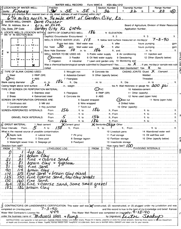
T22S, R33W, Sec. 36 SW SE SE |
Frusher, Dave | 186 ft. | 113 ft. | 30 gpm. | Domestic | Constructed | 03-Jul-1990 | Scan | |
|
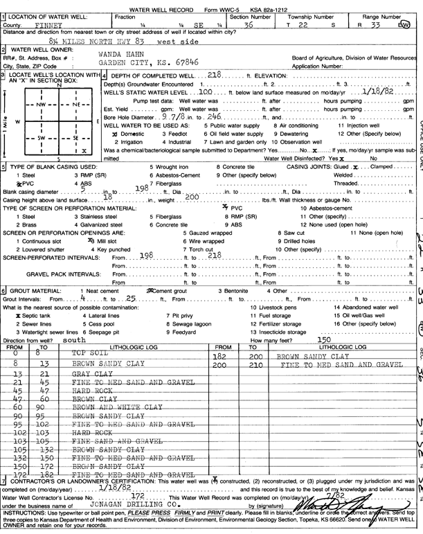
T22S, R33W, Sec. 36 SE |
Hahn, Wanda | 218 ft. | 100 ft. | Domestic | Constructed | 18-Jan-1982 | Scan | ||
|
T22S, R33W, Sec. 36 NE NE NE |
Hahn, Wendell and Wanda | 203 ft. | 81 ft. | 1775 gpm. | Irrigation | Constructed | 30-Oct-1980 | Scan | |
|
T22S, R33W, Sec. 36 SE SW SE |
Jarnagin, Joeseph | 215 ft. | 147 ft. | 75 gpm. | Domestic | Constructed | 16-Aug-2022 | ||
|
T22S, R33W, Sec. 36 SE SW SW NW |
Kirchoff, Rod | 236 ft. | 236 ft. | 808 gpm. | Irrigation | Constructed | 18-May-2017 |
KOLAR |
|
|
T22S, R33W, Sec. 36 SE |
Parks, Ken | 203 ft. | 117 ft. | Domestic | Constructed | 28-Jun-2001 | |||
|
T22S, R33W, Sec. 36 NE SE SW |
Robinson, Brandon | 215 ft. | 131 ft. | 70 gpm. | Domestic | Constructed | 30-Sep-2009 | ||
|
T22S, R33W, Sec. 36 NW SW SE |
Robinson, Fred | 217 ft. | 142 ft. | 100 gpm. | Domestic | Constructed | 07-Mar-2017 | ||
|
T22S, R34W, Sec. 1 SW NE SE |
Stroud, Steve | 130 ft. | 66 ft. | 2500 gpm. | Irrigation | Constructed | 31-Jul-1975 | Scan | |
|
T22S, R34W, Sec. 3 NW SE SE |
112.5 ft. | Irrigation | Plugged | 01-Jun-2008 | |||||
|
T22S, R34W, Sec. 3 NW SW NE |
93 ft. | Irrigation | Plugged | ||||||
|
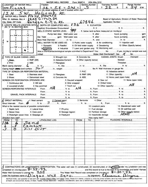
T22S, R34W, Sec. 5 SE SE SW |
Powers, Floyd | 136 ft. | Irrigation | Plugged | 29-Aug-1992 | Scan | |||
|
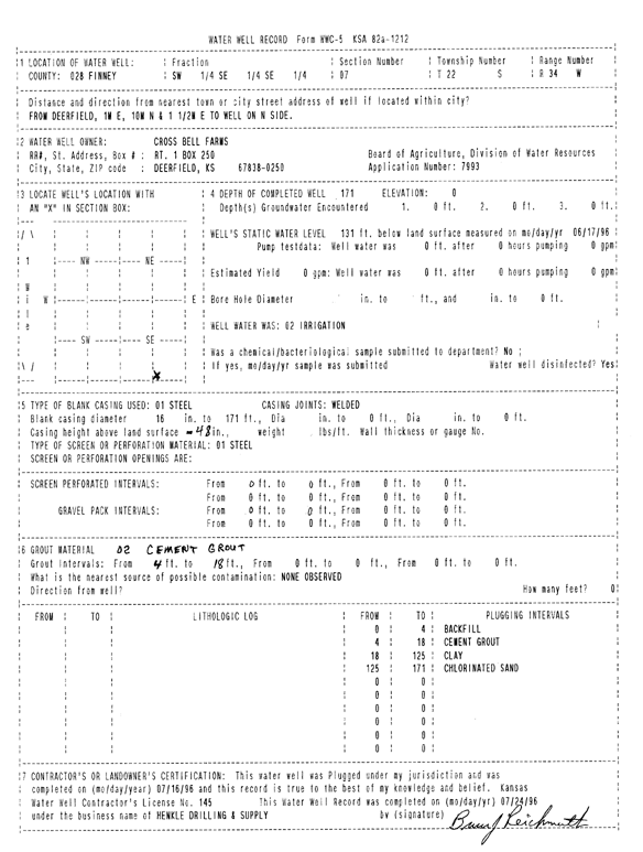
T22S, R34W, Sec. 7 SW SE SE |
Cross Bell Farms | 171 ft. | 131 ft. | Irrigation | Plugged | 16-Jul-1996 | Scan | ||
|
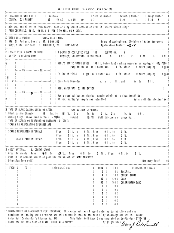
T22S, R34W, Sec. 7 NE SE SW |
Cross Bell Farms | 161 ft. | 133 ft. | Irrigation | Plugged | 16-Jul-1996 | Scan | ||
|
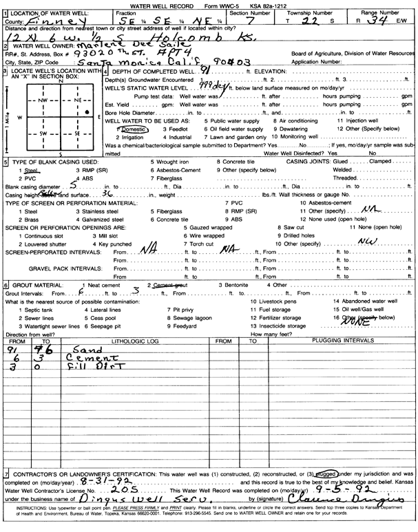
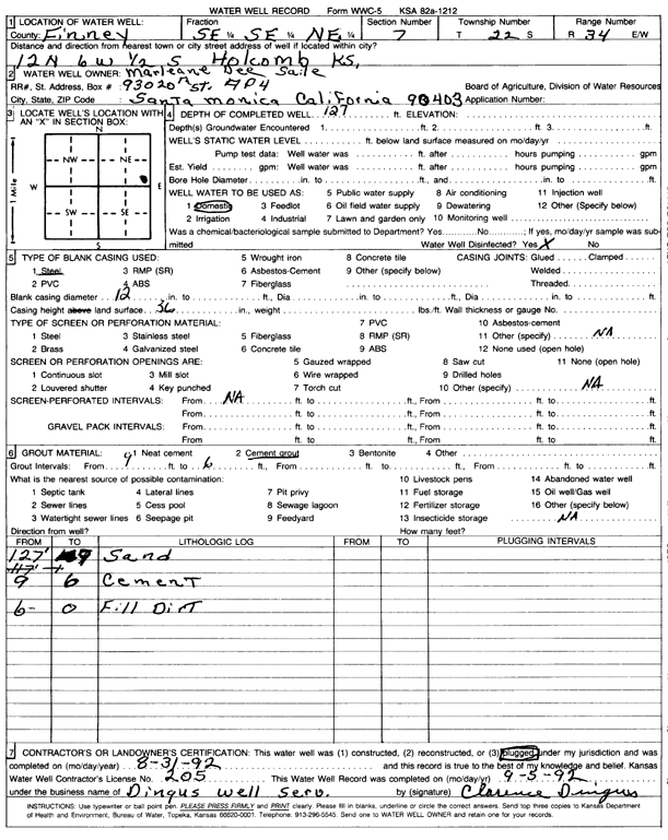
T22S, R34W, Sec. 7 SE SE NE |
Saile, Marlene Dee | 91 ft. | Domestic | Plugged | 31-Aug-1992 | Scan | |||
|
T22S, R34W, Sec. 7 SE SE NE |
Saile, Marlene Dee | 127 ft. | Domestic | Plugged | 31-Aug-1992 | Scan | |||
|
T22S, R34W, Sec. 8 NW SW NW |
Engler Farms, Inc. | 176 ft. | Irrigation | Plugged | 13-Dec-2005 | ||||
|
T22S, R34W, Sec. 8 SW NE NW |
Engler, Max | 175 ft. | Irrigation | Plugged | 25-Jul-2006 | ||||
|
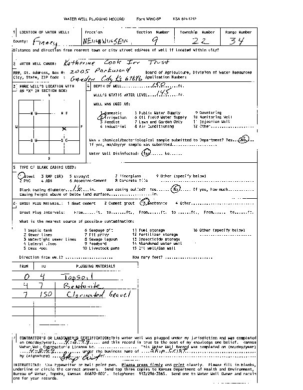
T22S, R34W, Sec. 9 NE NW SE |
Katherine Cook Irr Trust | 150 ft. | 145 ft. | Irrigation | Plugged | 08-Apr-1999 | Scan | ||
| View page: 1 || 2 || 3 || 4 || 5 || 6 || 7 || 8 || 9 || 10 || Next > | |||||||||