Select location of well to view details.
Click on column heading to sort.


|
|
|
County: Finney Select location of well to view details. Click on column heading to sort. |
|
|
|
| View page: < Prev || 101 || 102 || 103 || 104 || 105 || 106 || 107 || 108 || 109 || 110 | |||||||||
| T-R-S | Owner | Well Depth Ascend. Desc. |
Static Water Level Ascend. Desc. |
Est. Yield Ascend. Desc. |
Well Use | Other ID | Action Taken | Completion Date Ascend. Desc. |
Scan? |
|
T26S, R34W, Sec. 25 NW |
Wheatland Electric | 345 ft. | 270 ft. | Irrigation | G 124 | Plugged | 01-Jul-2011 | ||
|
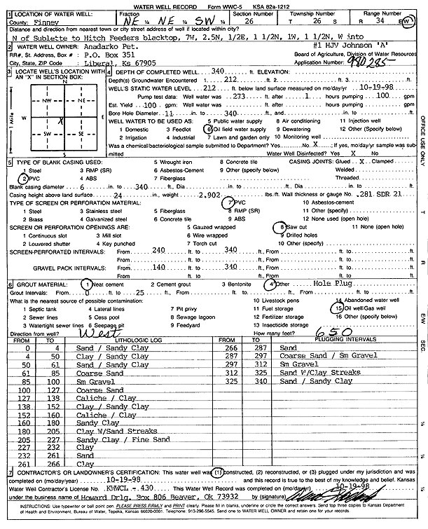
T26S, R34W, Sec. 26 NE NE SW |
Anadarko Petroleum Corp. | 340 ft. | 212 ft. | 100 gpm. | Oil Field Water Supply | HJV Johnson A-1 | Constructed | 19-Oct-1998 | Scan |
|
T26S, R34W, Sec. 26 C SW |
Gigot, Dean and Jerry | 390 ft. | 119 ft. | 1600 gpm. | Irrigation | Constructed | 21-Apr-1975 | Scan | |
|
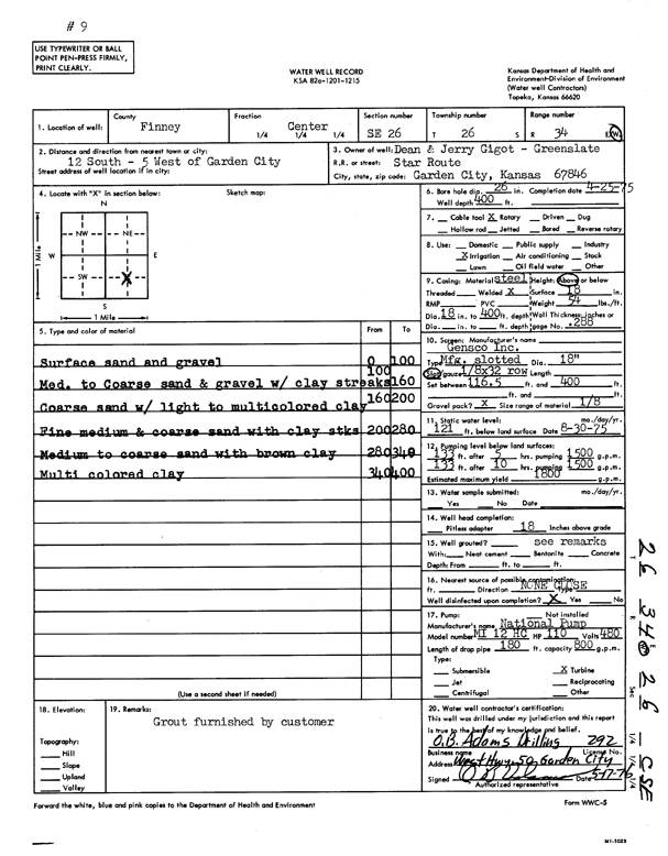
T26S, R34W, Sec. 26 C SE |
Gigot, Dean and Jerry | 400 ft. | 121 ft. | 1800 gpm. | Irrigation | Constructed | 25-Apr-1975 | Scan | |
|
T26S, R34W, Sec. 26 NE SW NE |
Gigot-Greenslate | 365 ft. | 119 ft. | 1325 gpm. | Irrigation | Constructed | 23-Jun-1976 | Scan | |
|
T26S, R34W, Sec. 26 NW SE NW |
Gigot-Greenslate | 365 ft. | 134 ft. | 1250 gpm. | Irrigation | Constructed | 28-Jun-1976 | Scan | |
|
T26S, R34W, Sec. 26 SW SW NE SE |
Neufeld, Jacob | 613 ft. | 294 ft. | 600 gpm. | Irrigation | Constructed | 31-Oct-2018 |
KOLAR |
|
|
T26S, R34W, Sec. 26 SE SE NE |
Neufeld, Jacob | 608 ft. | 342 ft. | 650 gpm. | Irrigation | Constructed | 28-Apr-2023 |
KOLAR |
|
|
T26S, R34W, Sec. 26 NE NE SE SW |
Neufeld, Jacob | 622 ft. | 327 ft. | 900 gpm. | Irrigation | Constructed | 17-Nov-2021 |
KOLAR |
|
|
T26S, R34W, Sec. 26 SE SE NW |
Wheatland Electric Coop, Inc. | 515 ft. | 262 ft. | Irrigation | Constructed | 26-Feb-2009 | |||
|
T26S, R34W, Sec. 27 SE |
Kearny County Feeders | 477 ft. | 172 ft. | 1050 gpm. | Irrigation | Constructed | 31-May-1986 | Scan | |
|
T26S, R34W, Sec. 27 NW |
Kearny County Feeders | 460 ft. | 125 ft. | 1250 gpm. | Irrigation | Constructed | 31-May-1986 | Scan | |
|
T26S, R34W, Sec. 27 E |
Kearny County Feeders | 500 ft. | 174 ft. | 1100 gpm. | Irrigation | Constructed | 31-May-1986 | Scan | |
|
T26S, R34W, Sec. 27 SW |
Kearny County Feeders | 415 ft. | 157 ft. | 1250 gpm. | Irrigation | Constructed | 31-May-1986 | Scan | |
|
T26S, R34W, Sec. 28 SW SW NW |
Cattle Empire | 447 ft. | 178 ft. | 50 gpm. | Domestic, Livestock | Constructed | 11-Jun-2014 | ||
|
T26S, R34W, Sec. 28 SW |
Kearny County Feeders | 465 ft. | 160 ft. | 1150 gpm. | Irrigation | Constructed | 31-May-1986 | Scan | |
|
T26S, R34W, Sec. 28 W2 NW NE |
Kearny County Feeders | 272 ft. | 175 ft. | Feedlot | Plugged | 18-Oct-1996 | Scan | ||
|
T26S, R34W, Sec. 28 SE |
Kearny County Feeders | 445 ft. | 127 ft. | 1150 gpm. | Irrigation | Constructed | 31-May-1986 | Scan | |
|
T26S, R34W, Sec. 28 NW |
Kearny County Feeders | 440 ft. | 152 ft. | 1250 gpm. | Irrigation | Constructed | 31-May-1986 | Scan | |
|
T26S, R34W, Sec. 28 W2 NW NE |
Kearny County Feeders | 272 ft. | 175 ft. | Oil Field Water Supply | Constructed | 11-Oct-1996 | Scan | ||
|
T26S, R34W, Sec. 28 NE |
Kearny County Feeders | 470 ft. | 129 ft. | 1150 gpm. | Irrigation | Constructed | 31-May-1986 | Scan | |
|
T26S, R34W, Sec. 29 NW SW NE |
Lewis, Tommy | 313 ft. | 97 ft. | Domestic, Livestock | Constructed | 09-Aug-1978 | Scan | ||
|
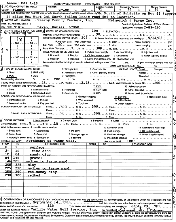
T26S, R34W, Sec. 31 C NE NW |
Kearny County Feeders | 300 ft. | 202 ft. | 50 gpm. | Oil Field Water Supply | USA A 16 | Plugged | 11-Oct-1983 | Scan |
|
T26S, R34W, Sec. 31 C NE NW |
Kearny County Feeders | 300 ft. | 202 ft. | 50 gpm. | Oil Field Water Supply | USA A 16 | Constructed | 14-Sep-1983 | Scan |
|
T26S, R34W, Sec. 33 NW NE SE |
Cheyenne Drilling Co. | 320 ft. | 210 ft. | Oil Field Water Supply | Cassidy 1-33 | Constructed | 29-Mar-1997 | Scan | |
|
T26S, R34W, Sec. 33 SW SW SW |
Kearny County Feeders | 320 ft. | 166 ft. | Domestic, Livestock | Constructed | 13-Jun-1986 | Scan | ||
|
T26S, R34W, Sec. 35 SW SW NE NE |
Deseret Trust 2 - 50899/Farm Land Reserve Inc. | 680 ft. | 312 ft. | 808 gpm. | Irrigation | Constructed | 03-Jun-2017 |
KOLAR |
|
|
T26S, R34W, Sec. 35 C SW |
Gigot, Dean and Jerry | 381 ft. | 127 ft. | 1600 gpm. | Irrigation | Constructed | 29-Apr-1975 | Scan | |
|
T26S, R34W, Sec. 35 C NE |
Gigot, Dean and Jerry | 379 ft. | 128 ft. | 1700 gpm. | Irrigation | Constructed | 27-Apr-1975 | Scan | |
|
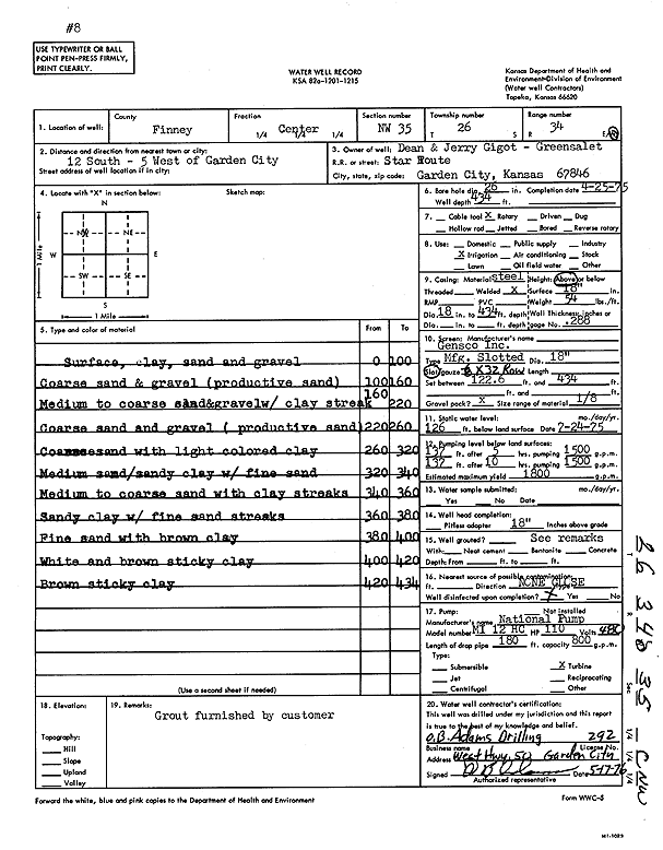
T26S, R34W, Sec. 35 C NW |
Gigot, Dean and Jerry | 434 ft. | 126 ft. | 1800 gpm. | Irrigation | Constructed | 25-Apr-1975 | Scan | |
|
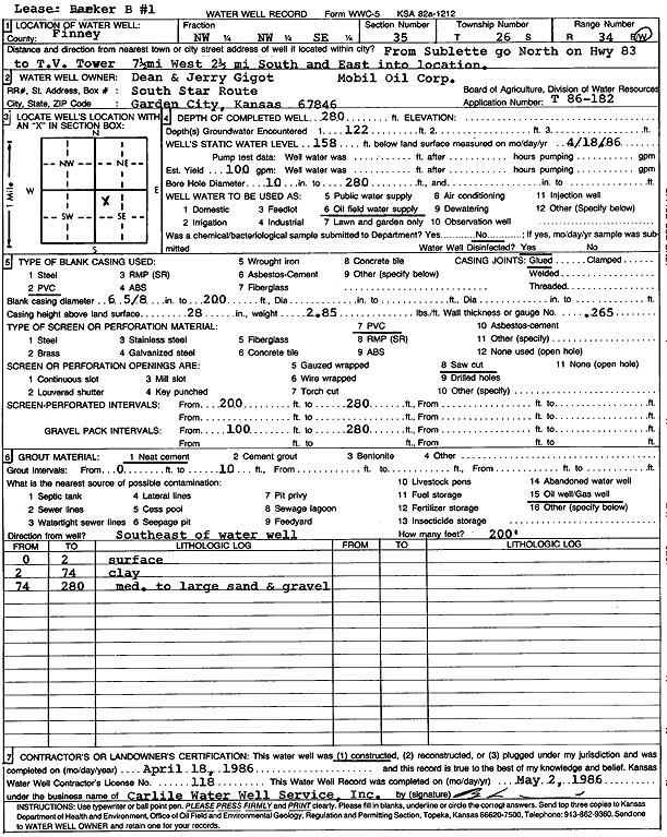
T26S, R34W, Sec. 35 NW NW SE |
Gigot, Dean and Jerry | 280 ft. | 158 ft. | 100 gpm. | Oil Field Water Supply | Barker B 1 | Constructed | 18-Apr-1986 | Scan |
|
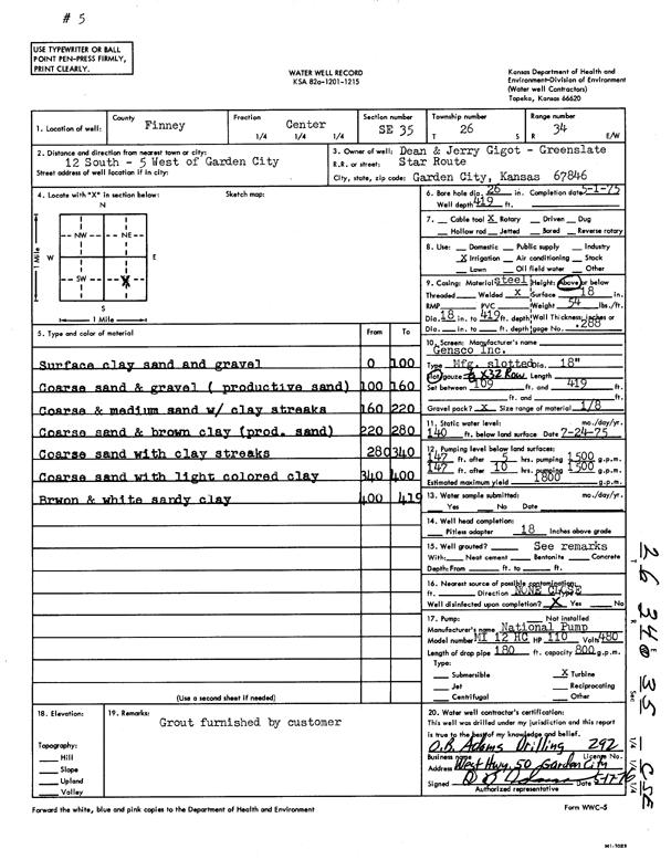
T26S, R34W, Sec. 35 C SE |
Gigot, Dean and Jerry | 419 ft. | 140 ft. | 1800 gpm. | Irrigation | Constructed | 01-May-1975 | Scan | |
|
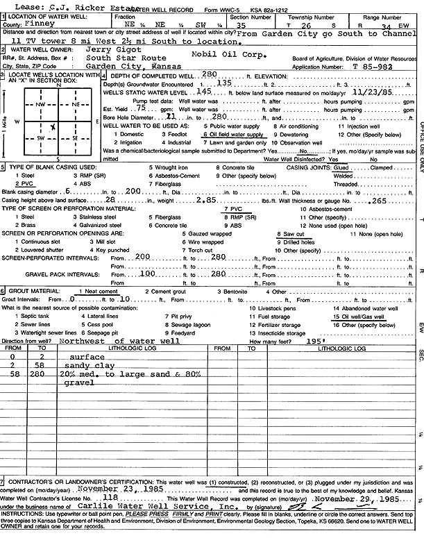
T26S, R34W, Sec. 35 NE NE SW |
Gigot, Jerry | 280 ft. | 145 ft. | 75 gpm. | Oil Field Water Supply | C.J. Ricker Estate | Constructed | 23-Nov-1985 | Scan |
|
T26S, R34W, Sec. 35 SE NW SE |
Stone, Greg | 500 ft. | 224 ft. | Irrigation | Constructed | 05-Apr-2002 | Scan | ||
|
T26S, R34W, Sec. 36 NW SE NW |
Batchelder, Roger | 358 ft. | 146 ft. | 1200 gpm. | Irrigation | Constructed | 31-May-1976 | Scan | |
|
T26S, R34W, Sec. 36 SW NE SW |
Batchelder, Roger | 367 ft. | 146 ft. | 1175 gpm. | Irrigation | Constructed | 31-May-1976 | Scan | |
|
T26S, R34W, Sec. 36 SE NW SE |
Batchelder, Roger | 380 ft. | 118 ft. | 1250 gpm. | Irrigation | Constructed | 31-May-1976 | Scan | |
|
T26S, R34W, Sec. 36 NE SW NE |
Batchelder, Roger | 352 ft. | 118 ft. | 1225 gpm. | Irrigation | Constructed | 31-May-1976 | Scan | |
|
T26S, R34W, Sec. 36 SE |
Gigot, Mike | 319 ft. | 140 ft. | Domestic | Constructed | 11-Jun-1982 | Scan | ||
|
T26S, R34W, Sec. 36 NE NE NW SW |
Hands, Janet Batchelder | 620 ft. | 338 ft. | 800 gpm. | Irrigation | Constructed | 12-May-2021 |
KOLAR |
|
|
T26S, R34W, Sec. 36 NE SW NE |
Hands, Janet Batchelder | 580 ft. | 366 ft. | 700 gpm. | Irrigation | JB-5 | Constructed | 04-Aug-2023 |
KOLAR |
|
T26S, R34W, Sec. 36 NW |
JB Circle Land | 358 ft. | 301.25 ft. | Irrigation | Circle 2 | Plugged | 24-Apr-2013 | ||
|
T26S, R34W, Sec. 36 SE SE NW NW |
JB Circle Land | 528 ft. | 300 ft. | 1003 gpm. | Irrigation | Constructed | 28-Mar-2013 |
KOLAR |
|
|
T26S, R34W, Sec. 36 NE |
JB Circle Land | 352 ft. | 274.5 ft. | Irrigation | Circle 1 | Plugged | 24-Apr-2013 | ||
| View page: < Prev || 101 || 102 || 103 || 104 || 105 || 106 || 107 || 108 || 109 || 110 | |||||||||