Select location of well to view details.
Click on column heading to sort.
|
|
|
County: Morton Select location of well to view details. Click on column heading to sort. |
|
|
|
| View page: < Prev || 21 || 22 || 23 || 24 || 25 | |||||||||
| T-R-S | Owner | Well Depth Ascend. Desc. |
Static Water Level Ascend. Desc. |
Est. Yield Ascend. Desc. |
Well Use | Other ID | Action Taken | Completion Date Ascend. Desc. |
Scan? |
|
T35S, R42W, Sec. 16 SE NW SW |
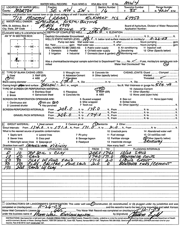
Spencer Distributing | 208 ft. | 189.1 ft. | Monitoring well/observation/piezometer | MW 4 | Constructed | 26-Nov-2003 | Scan | |
|
T35S, R42W, Sec. 16 SE NW SW |
Spencer Distributing | 199.83 ft. | 187.4 ft. | Monitoring well/observation/piezometer | MW 2 | Plugged | 20-Sep-2006 | ||
|
T35S, R42W, Sec. 16 SE NW SW |
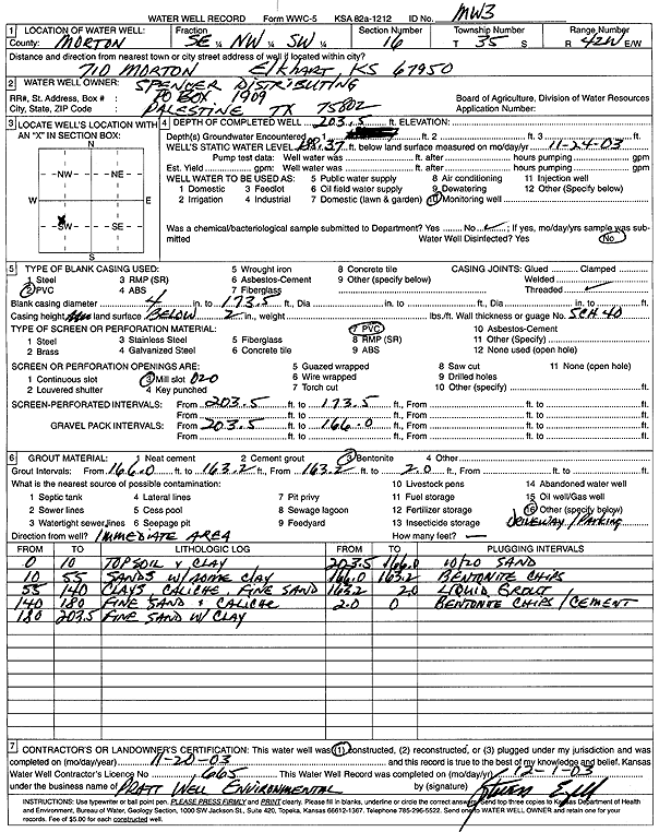
Spencer Distributing | 203.5 ft. | 188.37 ft. | Monitoring well/observation/piezometer | MW 3 | Constructed | 20-Nov-2003 | Scan | |
|
T35S, R42W, Sec. 16 SE NW SW |
Spencer Distributing | 213 ft. | 188.2 ft. | Monitoring well/observation/piezometer | MW 2 | Constructed | 18-Nov-2003 | Scan | |
|
T35S, R42W, Sec. 16 SE NW SW |
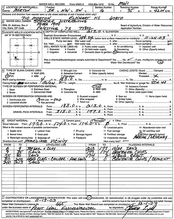
Spencer Distributing | 213 ft. | 188.34 ft. | Monitoring well/observation/piezometer | MW 1 | Constructed | 13-Nov-2003 | Scan | |
|
T35S, R42W, Sec. 16 SE NW SW |
Spencer Distributing | 196.44 ft. | 187.13 ft. | Monitoring well/observation/piezometer | MW 3 | Plugged | 20-Sep-2006 | ||
|
T35S, R42W, Sec. 17 SE SE SE |
City of Elkhart | 269 ft. | 235 ft. | Public Water Supply | Plugged | 14-Jul-1997 | |||
|
T35S, R42W, Sec. 17 C SE |
City of Elkhart | 271 ft. | 235 ft. | Public Water Supply | Well 3 | Plugged | 21-Apr-1994 | ||
|
T35S, R42W, Sec. 17 C S2 |
Elkhart Recreation | 240 ft. | 215 ft. | Public Water Supply | Plugged | 24-Mar-1994 | |||
|
T35S, R42W, Sec. 17 SE |
Farrington, E.R. | 365 ft. | 255 ft. | 30 gpm. | Domestic, Lawn and Garden | Constructed | 07-Sep-2007 | ||
|
T35S, R42W, Sec. 17 C SW SE |
Hedrick, Donald R. | 280 ft. | 225 ft. | 80 gpm. | Domestic | Constructed | 19-May-1975 | ||
|
T35S, R42W, Sec. 17 SE SE NW |
Wheeler Energy | 320 ft. | 180 ft. | 65 gpm. | Oil Field Water Supply | Constructed | 29-May-2006 | ||
|
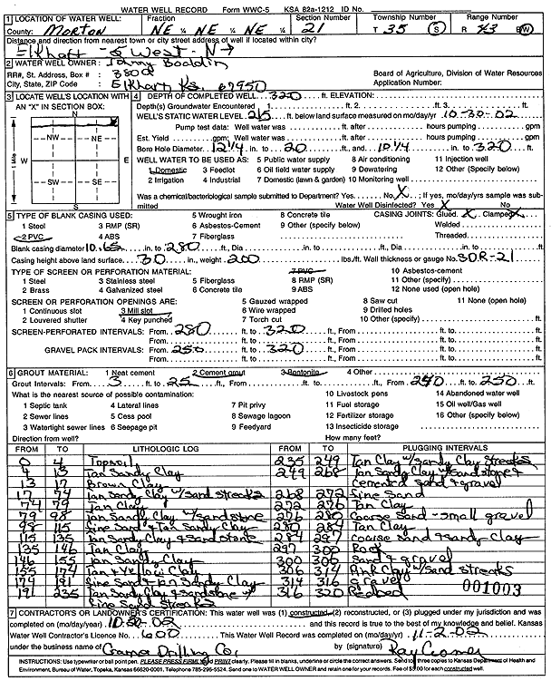
T35S, R43W, Sec. 3 SE SE NE |
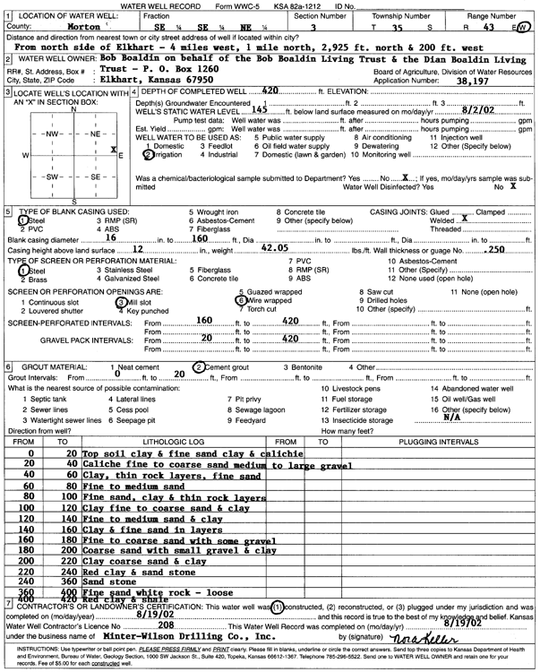
Boaldin, Bob | 420 ft. | 145 ft. | Irrigation | Constructed | 19-Aug-2002 | Scan | ||
|
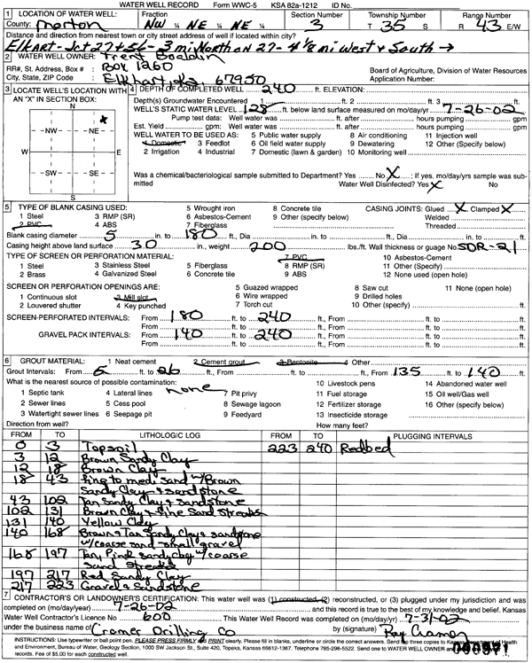
T35S, R43W, Sec. 3 NW NE NE |
Boaldin, Trent | 240 ft. | 128 ft. | Domestic | Constructed | 26-Jul-2002 | Scan | ||
|
T35S, R43W, Sec. 3 NE |
Kansas Geological Survey | 220 ft. | Monitoring well/observation/piezometer | 35-43-7 AAA 01 | Constructed | 01-Aug-1962 | |||
|
T35S, R43W, Sec. 3 SW SW |
Zenith Drilling | 220 ft. | 125 ft. | 60 gpm. | Oil Field Water Supply | Wacker 1 | Constructed | 04-Jul-1977 | |
|
T35S, R43W, Sec. 4 C NE SW |
Cimarron National Grassland | 96 ft. | Domestic, Livestock | Plugged | 10-Oct-1996 | ||||
|
T35S, R43W, Sec. 4 C SE |
Morton County Grazing Assoc. | 180 ft. | 95 ft. | 30 gpm. | Domestic, Livestock | Constructed | 15-Apr-1988 | ||
|
T35S, R43W, Sec. 4 SE SE NE |
Penick, William F. | 175 ft. | 85 ft. | Irrigation | Constructed | 28-Jul-1988 | |||
|
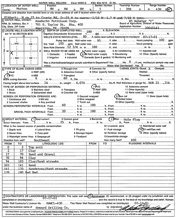
T35S, R43W, Sec. 5 NW NW SW |
Anadarko Petroleum Corp. | 180 ft. | 80 ft. | 100 gpm. | Oil Field Water Supply | Webster C-5 | Constructed | 17-Jul-2001 | Scan |
|
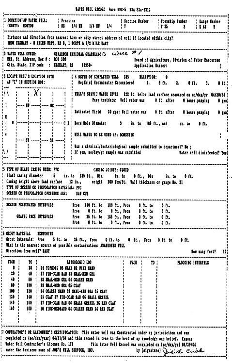
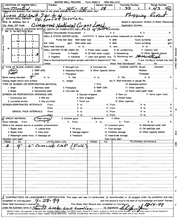
T35S, R43W, Sec. 6 SE NE |
Cimarron National Grassland | 16 ft. | 6 ft. | Oil Field Water Supply | Well 11 | Plugged | 06-Oct-1999 | Scan | |
|
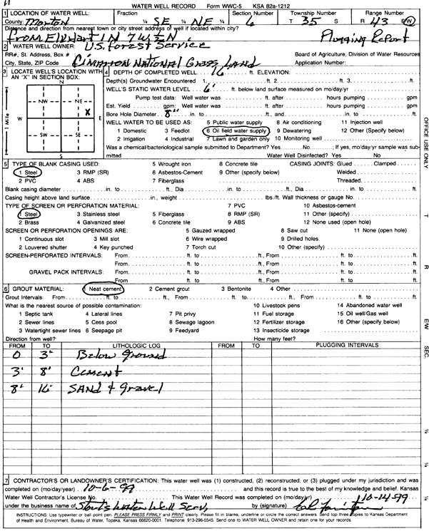
T35S, R43W, Sec. 7 NE NE NW |
Cimarron National Grassland | 185 ft. | 122 ft. | 30 gpm. | Domestic | Well 1 | Constructed | 21-Apr-2004 | Scan |
|
T35S, R43W, Sec. 7 NW NW NW |
Kansas Geological Survey | 140 ft. | Monitoring well/observation/piezometer | 35-43-7 bbb 01 | Constructed | 01-Aug-1962 | |||
|
T35S, R43W, Sec. 8 NW NW NW |
Cimarron National Grassland | (unstated)/abandoned | Plugged | 09-Oct-1997 | |||||
|
T35S, R43W, Sec. 9 NE SE SE |
Penick, Floyd | 14 ft. | Domestic | Constructed | 29-Sep-2003 | Scan | |||
|
T35S, R43W, Sec. 9 SE SE SE |
Penick, Ina | 326 ft. | 221 ft. | 30 gpm. | Domestic | Constructed | 16-May-2004 | ||
|
T35S, R43W, Sec. 10 C N2 |
Morton County Grazing Assoc. | 240 ft. | 145 ft. | 60 gpm. | Domestic | Constructed | 24-Apr-1987 | ||
|
T35S, R43W, Sec. 10 C N2 |
Morton County Grazing Assoc. | 240 ft. | 145 ft. | 70 gpm. | Domestic, Livestock | Constructed | 24-Apr-1987 | ||
|
T35S, R43W, Sec. 10 C NW NE |
U.S. Forest Service | 205 ft. | 132 ft. | Domestic, Livestock | A-10 | Plugged | 07-Oct-1992 | ||
|
T35S, R43W, Sec. 13 SE SW SW |
Hugoton Energy | 320 ft. | 240 ft. | 65 gpm. | Oil Field Water Supply | Vyn 1 | Constructed | 29-Mar-1989 | |
|
T35S, R43W, Sec. 15 NE NE NE |
Boaldin, Bob | 325 ft. | 222 ft. | 30 gpm. | Domestic | Constructed | 16-Feb-2000 | Scan | |
|
T35S, R43W, Sec. 15 NW |
Penick, Floyd | 330 ft. | 190 ft. | Irrigation | Constructed | 22-May-1984 | |||
|
T35S, R43W, Sec. 15 NW NE NE |
Penick, William F. | 300 ft. | 192 ft. | 60 gpm. | Domestic | Constructed | 13-Dec-1976 | ||
|
T35S, R43W, Sec. 16 SW |
Boaldin, Johnny | 305 ft. | 238 ft. | Irrigation | Plugged | 24-Sep-2012 | |||
|
T35S, R43W, Sec. 16 SE NE SW |
Boaldin, Johnny | 315 ft. | 210 ft. | Irrigation | Constructed | 15-Apr-1993 | |||
|
T35S, R43W, Sec. 16 SE NE SW |
Boaldin, Johnny | 324 ft. | 234 ft. | Irrigation | Constructed | 10-Oct-2011 | |||
|
T35S, R43W, Sec. 16 SW |
Boaldin, Johnny | 15 ft. | Irrigation | Plugged | 24-Sep-2012 | ||||
|
T35S, R43W, Sec. 16 NE NE SE |
Boaldin, Johnny B. | 315 ft. | 64 ft. | 850 gpm. | Irrigation | Plugged | 09-Nov-1993 | ||
|
T35S, R43W, Sec. 17 C S2 SE |
Mid-Western Exploration | 320 ft. | 206 ft. | 60 gpm. | Oil Field Water Supply | Gear 1-17 | Constructed | 08-Aug-1983 | |
|
T35S, R43W, Sec. 18 NE SE |
Cimarron National Grassland | Domestic | Plugged | 28-Sep-1999 | Scan | ||||
|
T35S, R43W, Sec. 18 C S2 SE |
Cimarron National Grassland | 312 ft. | 160 ft. | Oil Field Water Supply | Constructed | 13-Nov-1982 | |||
|
T35S, R43W, Sec. 19 NE NE NW |
Cimarron National Grassland | 160 ft. | (unstated)/abandoned | Plugged | 09-Oct-1997 | ||||
|
T35S, R43W, Sec. 21 NE NE NE |
Boaldin, Johnny | 320 ft. | 215 ft. | Domestic | Constructed | 20-Oct-2002 | Scan | ||
|
T35S, R43W, Sec. 21 C NW |
Ensign Operating Co. | 320 ft. | 200 ft. | 115 gpm. | Oil Field Water Supply | Boaldin 1-21 | Constructed | 08-May-1993 | |
|
T35S, R43W, Sec. 21 C NW |
Oxy USA, Inc. | 320 ft. | Oil Field Water Supply | Plugged | 23-Sep-2011 | ||||
|
T35S, R43W, Sec. 22 NE NE |
Kansas Geological Survey | 330 ft. | Monitoring well/observation/piezometer | 22 AA | Constructed | 21-Aug-1962 | |||
|
T35S, R43W, Sec. 24 SE NW NW |
City of Elkhart | 370 ft. | 202 ft. | 3000 gpm. | Public Water Supply | Constructed | 16-Feb-1981 | ||
|
T35S, R43W, Sec. 24 N2 NE |
City of Elkhart | 358 ft. | 235 ft. | Public Water Supply | Constructed | 22-Apr-1999 | Scan | ||
|
T35S, R43W, Sec. 24 NE NE NE |
City of Elkhart | 371 ft. | 238 ft. | Public Water Supply | Reconstructed | 27-Apr-1999 | Scan | ||
|
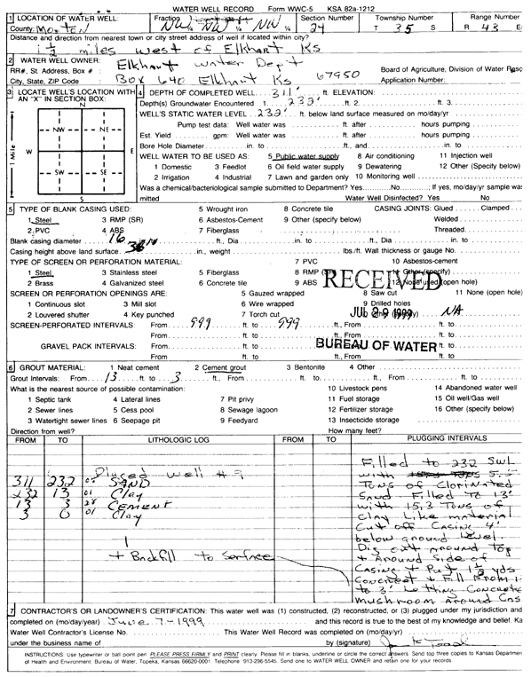
T35S, R43W, Sec. 24 NW NW NW |
City of Elkhart Water Dept. | 311 ft. | 232 ft. | Public Water Supply | Plugged | 07-Jun-1999 | Scan | ||
| View page: < Prev || 21 || 22 || 23 || 24 || 25 | |||||||||