Select location of well to view details.
Click on column heading to sort.
|
|
|
County: Russell Select location of well to view details. Click on column heading to sort. |
|
|
|
| View page: < Prev || 21 || 22 || 23 || 24 || 25 || 26 || 27 || 28 || 29 || 30 || Next > | |||||||||
| T-R-S | Owner | Well Depth Ascend. Desc. |
Static Water Level Ascend. Desc. |
Est. Yield Ascend. Desc. |
Well Use | Other ID | Action Taken | Completion Date Ascend. Desc. |
Scan? |
|
T14S, R12W, Sec. 30 NW SW SE |
Morris, Mark | 90 ft. | 34 ft. | 25 gpm. | Domestic, Lawn and Garden | Constructed | 15-Mar-2013 | ||
|
T14S, R12W, Sec. 31 SE NW SE |
Karel Pekarek Farms | 104 ft. | 44 ft. | 10 gpm. | Domestic | Constructed | 26-Jun-2006 | ||
|
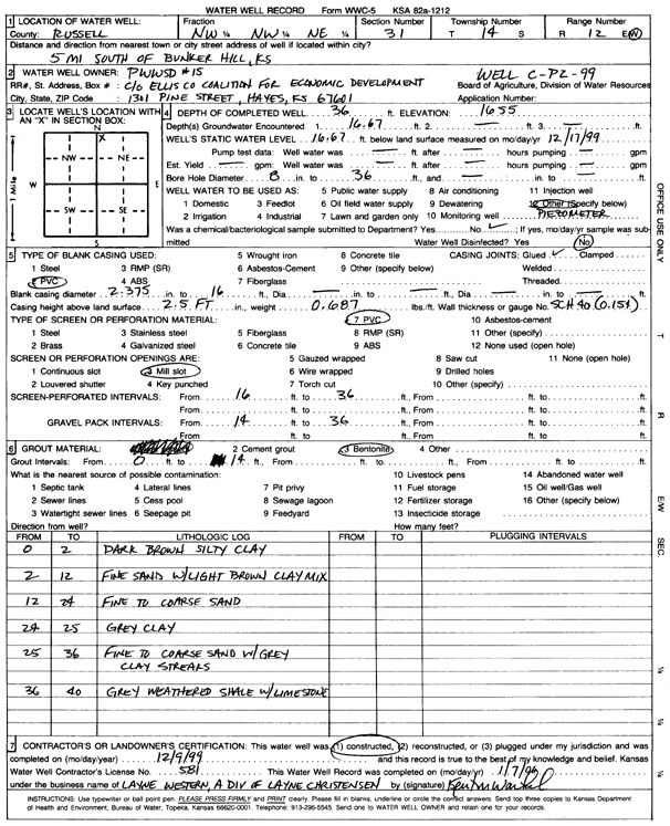
T14S, R12W, Sec. 31 NW NW NE |
Public Wholesale Water Supply District 15 | 36 ft. | 16.67 ft. | Monitoring well/observation/piezometer | Wel C-P2-99 | Constructed | 09-Dec-1999 | Scan | |
|
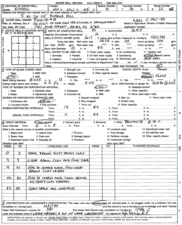
T14S, R12W, Sec. 31 NW NW NE |
Public Wholesale Water Supply District 15 | 43 ft. | 16.17 ft. | 200 gpm. | Test hole/well | Well C-PW-99 | Constructed | 11-Dec-1999 | Scan |
|
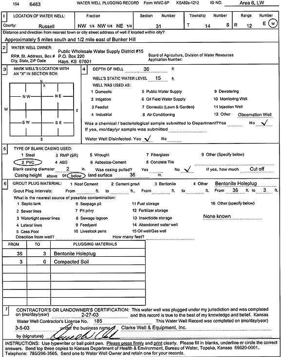
T14S, R12W, Sec. 31 NW NW NE |
Public Wholesale Water Supply District 15 | 36 ft. | 15 ft. | Monitoring well/observation/piezometer | Area 6, LW | Plugged | 27-Feb-2003 | Scan | |
|
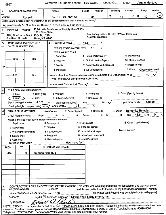
T14S, R12W, Sec. 31 C NW |
Public Wholesale Water Supply District 15 | 46.5 ft. | 15 ft. | Monitoring well/observation/piezometer | Area 6 Montoya | Plugged | 13-May-2002 | Scan | |
|
T14S, R12W, Sec. 32 NW NE SE |
TD2 Farms LLC | 90 ft. | 35 ft. | Domestic | Plugged | 13-Sep-2012 | |||
|
T14S, R12W, Sec. 32 NW NE SE |
TD2 Farms LLC | 86 ft. | 30 ft. | Domestic, Lawn and Garden | Constructed | 28-Aug-2012 | |||
|
T14S, R12W, Sec. 33 NW |
Kepta, Jaz | 140 ft. | Domestic, Livestock | Plugged | 13-Nov-2016 | ||||
|
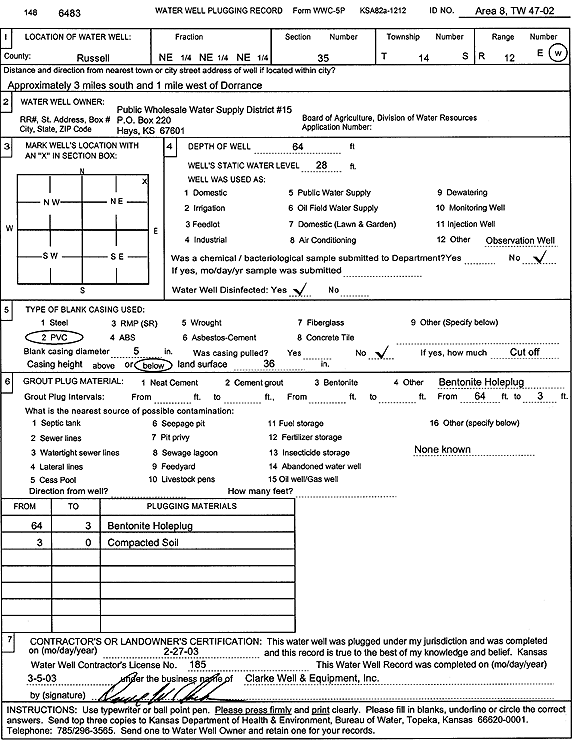
T14S, R12W, Sec. 35 NE NE NE |
Public Wholesale Water Supply District 15 | 67 ft. | 19 ft. | Test hole/well | Area 8, TW 47-02 | Constructed | 08-Mar-2002 | Scan | |
|
T14S, R12W, Sec. 35 NE NE NE |
Public Wholesale Water Supply District 15 | 64 ft. | 28 ft. | Monitoring well/observation/piezometer | Area 8, TW 47-02 | Plugged | 27-Feb-2003 | Scan | |
|
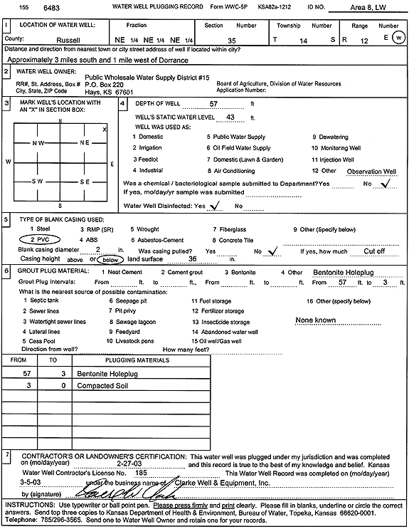
T14S, R12W, Sec. 35 NE NE NE |
Public Wholesale Water Suppy Distric 15 | 57 ft. | 43 ft. | Monitoring well/observation/piezometer | Area 8, LW | Plugged | 27-Feb-2003 | Scan | |
|
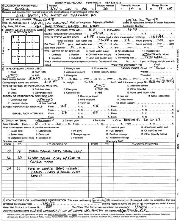
T14S, R12W, Sec. 36 NW NW NW |
Public Wholesale Water Supply District 15 | 55 ft. | 24.58 ft. | 200 gpm. | Test hole/well | Well D-PW-99 | Constructed | 13-Dec-1999 | Scan |
|
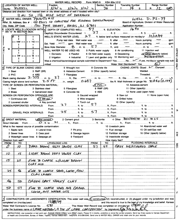
T14S, R12W, Sec. 36 NW NW NW |
Public Wholesale Water Supply District 15 | 57 ft. | 27 ft. | Monitoring well/observation/piezometer | Well D-P2-99 | Constructed | 08-Dec-1999 | Scan | |
|
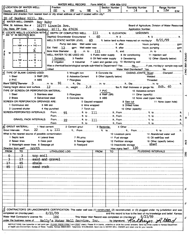
T14S, R12W, Sec. 36 SE SW NE |
Ruby, Ray | 111 ft. | 60 ft. | 12 gpm. | Domestic | Constructed | 21-Aug-1999 | Scan | |
|
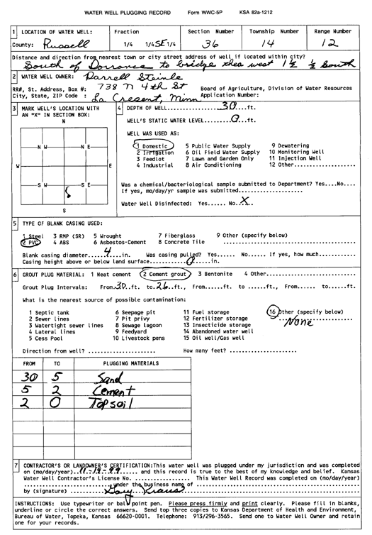
T14S, R12W, Sec. 36 NW SE SE |
Steinle, Darrell | 44 ft. | 21 ft. | 10 gpm. | Domestic | Constructed | 14-Oct-1999 | ||
|
T14S, R12W, Sec. 36 SE |
Stienle, Darrell | 30 ft. | Domestic | Plugged | 19-Nov-1999 | Scan | |||
|
T14S, R12W, Sec. 36 SE SE SE |
Wirth, Kevin | 42 ft. | Domestic, Livestock | Constructed | 25-Jun-2004 | ||||
|
T14S, R12W, Sec. 36 SE SW SE |
Wirth, Kevin | 80 ft. | 60 ft. | Domestic, Livestock | Constructed | 05-Jun-2024 |
KOLAR |
||
|
T14S, R13W, Sec. 2 SW |
Jorn, Jeremy | 50 ft. | Domestic, Lawn and Garden | Plugged | 31-Oct-2014 | ||||
|
T14S, R13W, Sec. 3 SE SE NE |
Amoco Oil Co. | 31 ft. | 22 ft. | Monitoring well/observation/piezometer | Constructed | 14-Mar-1991 | |||
|
T14S, R13W, Sec. 3 SE SE NE |
Amoco Oil Co. | 30 ft. | 22 ft. | Monitoring well/observation/piezometer | Constructed | 13-Mar-1991 | |||
|
T14S, R13W, Sec. 7 NE NW SW |
Pohlman, Marge | 223 ft. | 175 ft. | 20 gpm. | Domestic, Livestock | Reconstructed | 27-Jul-2015 | ||
|
T14S, R13W, Sec. 10 NW NW SW |
Triple S | 217 ft. | 155 ft. | Domestic | Constructed | 28-Nov-1995 | |||
|
T14S, R13W, Sec. 12 SE NE SE |
City of Bunker Hill | 270 ft. | 140 ft. | 100 gpm. | Public Water Supply | Constructed | 20-Dec-1975 | ||
|
T14S, R13W, Sec. 12 SE NE SE |
City of Bunker Hill | 267 ft. | 146 ft. | 55 gpm. | Public Water Supply | Constructed | 04-Sep-1985 | ||
|
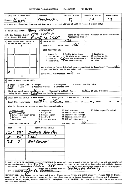
T14S, R13W, Sec. 17 SW SW SW |
Driscoll, Jerry | 125 ft. | 100 ft. | Domestic, Lawn and Garden | Plugged | 24-Jun-1999 | Scan | ||
|
T14S, R13W, Sec. 17 SW NW NW NW |
Nichols, Connie | 170 ft. | 150 ft. | Domestic | Plugged | 27-Sep-2018 |
KOLAR |
||
|
T14S, R13W, Sec. 21 SE SE NW |
Driscoll, John | 185 ft. | 117 ft. | Domestic, Livestock | Constructed | 20-Oct-2010 | |||
|
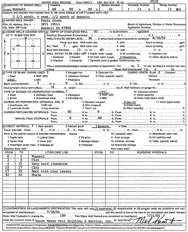
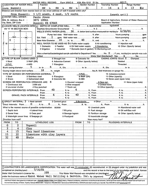
T14S, R13W, Sec. 21 NW SW NW |
Jones, Paula | 40 ft. | 30 ft. | 2 gpm. | Dewatering | Constructed | 16-Jul-2001 | Scan | |
|
T14S, R13W, Sec. 21 NW SW NW |
Jones, Paula | 40 ft. | 30 ft. | 2 gpm. | Dewatering | N Well | Constructed | 16-Jul-2001 | Scan |
|
T14S, R13W, Sec. 26 SE SE NE |
Boomhower, Jesse | 50 ft. | 25 ft. | 4.5 gpm. | Domestic, Livestock | Constructed | 23-Mar-2023 |
KOLAR |
|
|
T14S, R13W, Sec. 27 SW NE SE |
Biesterfeld, Dugne A. | 39 ft. | 16.5 ft. | Domestic | Constructed | 07-Jun-1990 | |||
|
T14S, R13W, Sec. 27 NW NE SW |
Neill, Junior | 160 ft. | 61 ft. | Industrial | Constructed | 21-Sep-2006 | |||
|
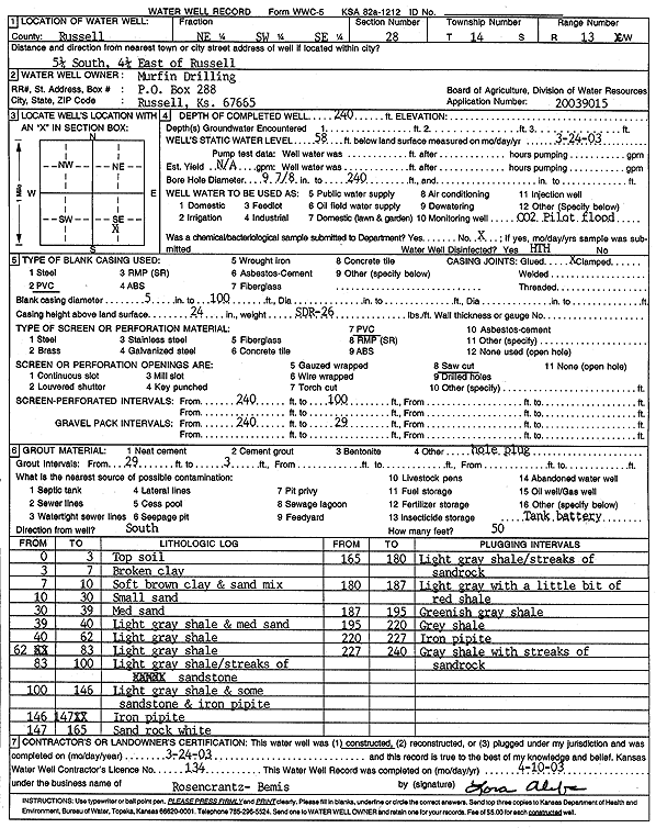
T14S, R13W, Sec. 28 NE SW SE |
Murfin Drilling | 240 ft. | 58 ft. | Other
(CO2 Pilot Flood) |
Constructed | 24-Mar-2003 | Scan | ||
|
T14S, R13W, Sec. 31 NW SE NE |
C12: Kansas Oil, LLC | 257 ft. | 48 ft. | Oil Field Water Supply | Constructed | 07-Oct-2014 | |||
|
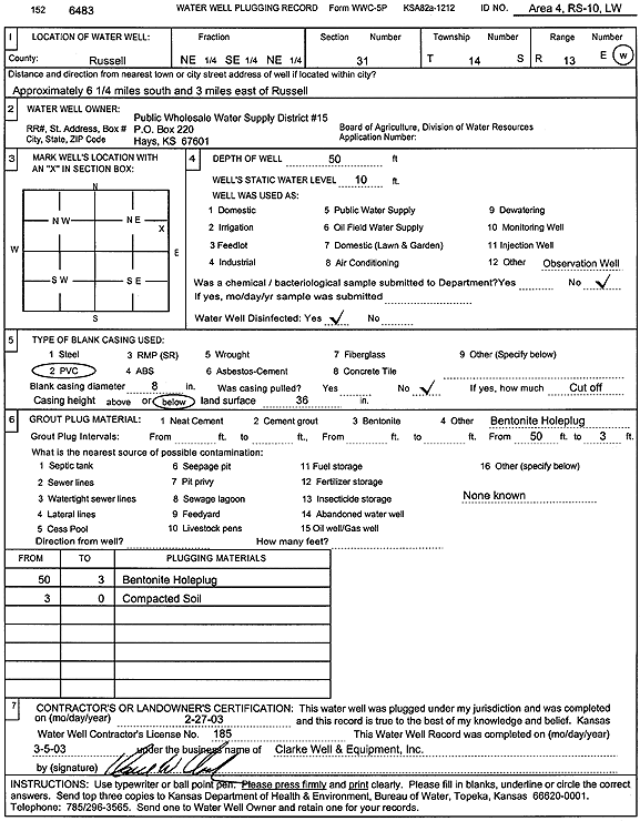
T14S, R13W, Sec. 31 NE SE NE |
Public Wholesale Water Supply District 15 | 50 ft. | 10 ft. | Monitoring well/observation/piezometer | Area 4 - RS - 10, LW | Plugged | 27-Feb-2003 | Scan | |
|
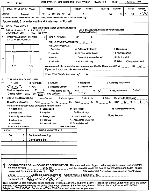
T14S, R13W, Sec. 31 NE SE NE |
Public Wholesale Water Supply District 15 | 50 ft. | 10 ft. | Monitoring well/observation/piezometer | Area 4 - LW | Plugged | 27-Feb-2003 | Scan | |
|
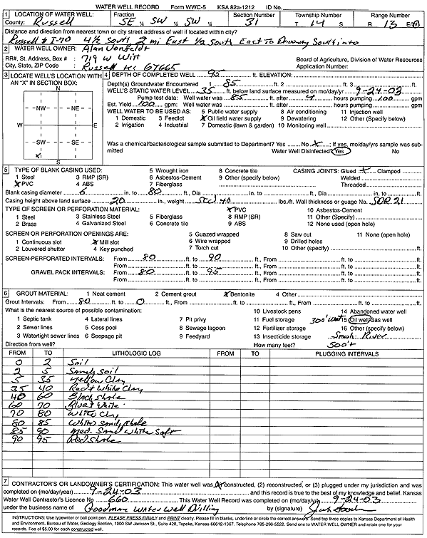
T14S, R13W, Sec. 31 SE SW SW |
Vonfeldt, Alan | 95 ft. | 35 ft. | 100 gpm. | Oil Field Water Supply | Constructed | 24-Sep-2003 | Scan | |
|
T14S, R13W, Sec. 32 NE SE NE |
Kansas Geological Survey | 19 ft. | 11 ft. | Monitoring well/observation/piezometer | Constructed | 08-Jun-1983 | |||
|
T14S, R13W, Sec. 32 NW NW NE |
Kansas Geological Survey | 30 ft. | 29.5 ft. | Monitoring well/observation/piezometer | Constructed | 07-Jun-1983 | |||
|
T14S, R13W, Sec. 32 NE SE NE |
Kansas Geological Survey | 25 ft. | 11 ft. | Monitoring well/observation/piezometer | Constructed | 10-Jun-1983 | |||
|
T14S, R13W, Sec. 32 NE SE NE |
Kansas Geological Survey | 51 ft. | 11.5 ft. | Monitoring well/observation/piezometer | Constructed | 14-Jun-1983 | |||
|
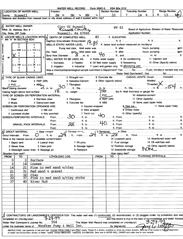
T14S, R13W, Sec. 33 SW SW NW |
City of Russell | 40 ft. | 19.85 ft. | Monitoring well/observation/piezometer | PW 2 | Constructed | 29-Mar-1999 | Scan | |
|
T14S, R13W, Sec. 33 SE NW SE |
Ohlson, Terry | 160 ft. | 69 ft. | Domestic | Constructed | 23-Jun-2007 | |||
|
T14S, R13W, Sec. 33 NW NW SE |
Olsen, Terry | 85 ft. | 43 ft. | Domestic, Livestock | Constructed | 14-Oct-2004 | |||
|
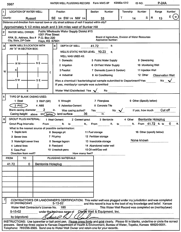
T14S, R13W, Sec. 33 SE SW NW |
Public Wholesale Water Supply District 15 | 41.72 ft. | 10.23 ft. | Monitoring well/observation/piezometer | P 24 A | Plugged | 13-May-2002 | Scan | |
|
T14S, R13W, Sec. 33 SE SW NW |
Public Wholesale Water Supply District 15 | 58.8 ft. | 10.5 ft. | Monitoring well/observation/piezometer | P 24 | Plugged | 13-May-2002 | Scan | |
|
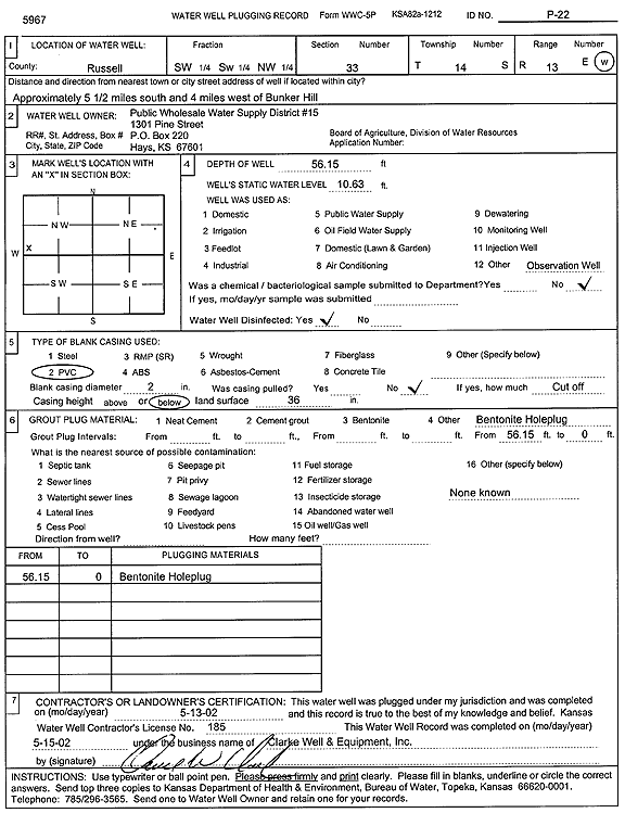
T14S, R13W, Sec. 33 SW SW NW |
Public Wholesale Water Supply District 15 | 56.15 ft. | 10.63 ft. | Monitoring well/observation/piezometer | P 22 | Plugged | 13-May-2002 | Scan | |
|
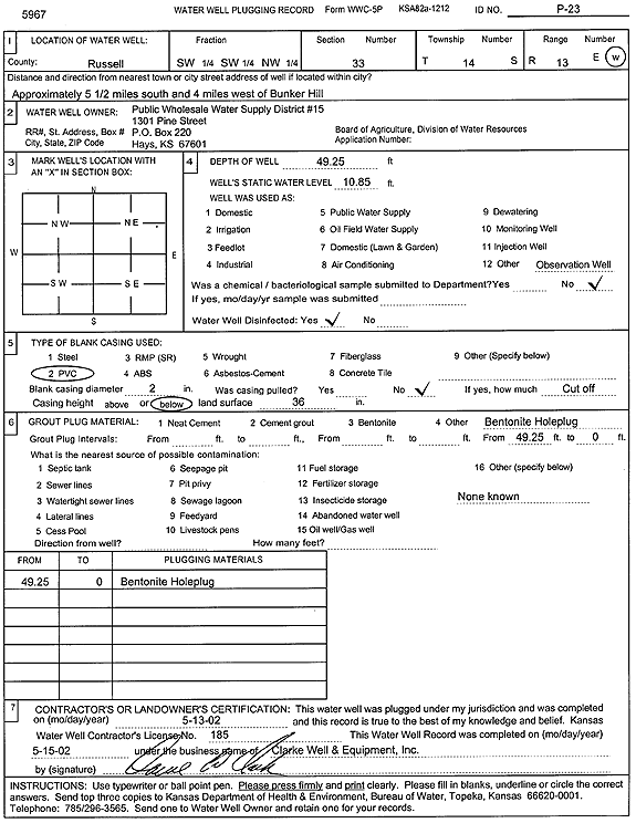
T14S, R13W, Sec. 33 SW SW NW |
Public Wholesale Water Supply District 15 | 49.25 ft. | 10.85 ft. | Monitoring well/observation/piezometer | P 23 | Plugged | 13-May-2002 | Scan | |
| View page: < Prev || 21 || 22 || 23 || 24 || 25 || 26 || 27 || 28 || 29 || 30 || Next > | |||||||||