Select location of well to view details.
Click on column heading to sort.
|
|
|
County: Sherman Select location of well to view details. Click on column heading to sort. |
|
|
|
| View page: < Prev || 11 || 12 || 13 || 14 || 15 || 16 || 17 || 18 || 19 || 20 || Next > | |||||||||
| T-R-S | Owner | Well Depth Ascend. Desc. |
Static Water Level Ascend. Desc. |
Est. Yield Ascend. Desc. |
Well Use | Other ID | Action Taken | Completion Date Ascend. Desc. |
Scan? |
|
T8S, R39W, Sec. 18 SE NE SW |
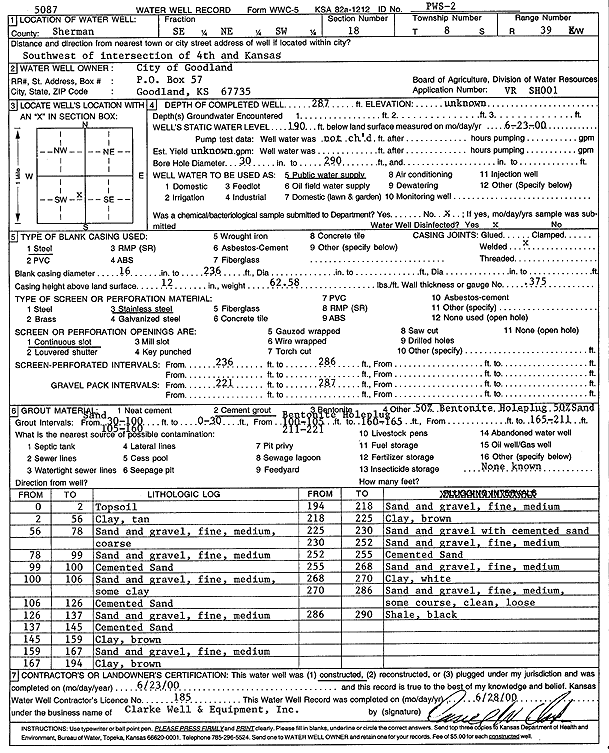
City of Goodland | 289 ft. | 121.75 ft. | Test hole/well | TW 2-98 | Constructed | 16-Apr-1998 | ||
|
T8S, R39W, Sec. 18 SE NE SW |
City of Goodland | 287 ft. | 190 ft. | Public Water Supply | PWS 2 | Constructed | 23-Jun-2000 | Scan | |
|
T8S, R39W, Sec. 18 SE SE SE |
Kabredlo's | 211.3 ft. | 188.8 ft. | Monitoring well/observation/piezometer | MW 4 | Plugged | 04-Feb-2008 | ||
|
T8S, R39W, Sec. 18 SE SE SE |
Kabredlo's | 211.9 ft. | 188.45 ft. | Monitoring well/observation/piezometer | MW 2 | Plugged | 04-Feb-2008 | ||
|
T8S, R39W, Sec. 18 SE SE SE |
Kabredlo's | 211.34 ft. | 188.92 ft. | Monitoring well/observation/piezometer | MW 1 | Plugged | 04-Feb-2008 | ||
|
T8S, R39W, Sec. 18 SE SE SE |
KDHE | 290 ft. | 193.9 ft. | Monitoring well/observation/piezometer | MW 15 D | Constructed | 25-Mar-2009 | ||
|
T8S, R39W, Sec. 18 SE SE SE |
KDHE | 270 ft. | 190.04 ft. | Monitoring well/observation/piezometer | MW 3 D | Constructed | 23-Mar-2009 | ||
|
T8S, R39W, Sec. 18 SE SE SE |
KDHE | 230 ft. | 187.75 ft. | Monitoring well/observation/piezometer | MW 31 S | Constructed | 25-Mar-2009 | ||
|
T8S, R39W, Sec. 18 SE SE SE |
Olderbak, Mike/Kabredlo's | 210 ft. | Monitoring well/observation/piezometer | MW 3 | Constructed | 27-Mar-2006 | |||
|
T8S, R39W, Sec. 18 SE SE SE |
Olderbak, Mike/Kabredlo's | 215 ft. | Monitoring well/observation/piezometer | MW 2 | Constructed | 28-Mar-2006 | |||
|
T8S, R39W, Sec. 18 SE SE SE |
Olderbak, Mike/Kabredlo's | 210 ft. | Monitoring well/observation/piezometer | MW 4 | Constructed | 29-Mar-2006 | |||
|
T8S, R39W, Sec. 18 SW SW SW |
Sherman County | 221.5 ft. | 188.91 ft. | Monitoring well/observation/piezometer | BH 3/MW 1 | Constructed | 10-Aug-1998 | ||
|
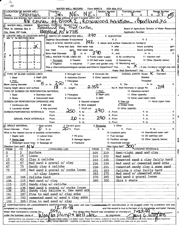
T8S, R39W, Sec. 18 SW NE NE |
Sherman County Hospital | 290 ft. | 192 ft. | Domestic | Constructed | 15-Dec-1998 | Scan | ||
|
T8S, R39W, Sec. 18 SW SW SW |
Sherman County Shop | 227 ft. | 188.97 ft. | Monitoring well/observation/piezometer | Constructed | 15-May-1992 | |||
|
T8S, R39W, Sec. 19 SE SE NW SW |
ADM Grain | 230 ft. | 200 ft. | Monitoring well/observation/piezometer | MW 103 | Constructed | 03-Dec-2013 |
KOLAR |
|
|
T8S, R39W, Sec. 19 NW SE NW SW |
ADM Grain | 230 ft. | 200 ft. | Monitoring well/observation/piezometer | MW 104 | Constructed | 02-Dec-2013 |
KOLAR |
|
|
T8S, R39W, Sec. 19 SW NE SW |
ADM Grain | 230 ft. | Monitoring well/observation/piezometer | MW 102 | Constructed | 01-Dec-2010 | |||
|
T8S, R39W, Sec. 19 NW SW SW |
ADM Grain | 230 ft. | Monitoring well/observation/piezometer | MW 101 | Constructed | 30-Nov-2010 | |||
|
T8S, R39W, Sec. 19 SW NW NW |
City of Goodland | 278 ft. | 179.7 ft. | Public Water Supply | Constructed | 06-Jul-2000 | Scan | ||
|
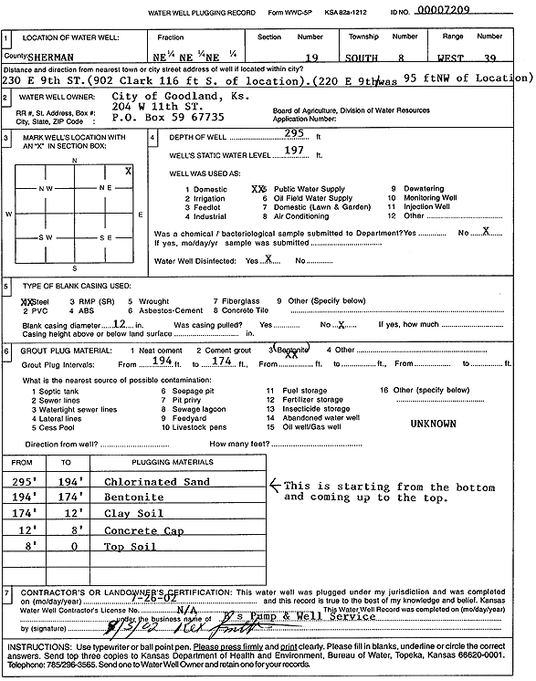
T8S, R39W, Sec. 19 NE NE NE |
City of Goodland | 295 ft. | 197 ft. | Public Water Supply | Plugged | 26-Jul-2002 | Scan | ||
|
T8S, R39W, Sec. 19 NE SW NW NW |
City of Goodland | 278 ft. | 198 ft. | Public Water Supply | Plugged | 08-Feb-2017 |
KOLAR |
||
|
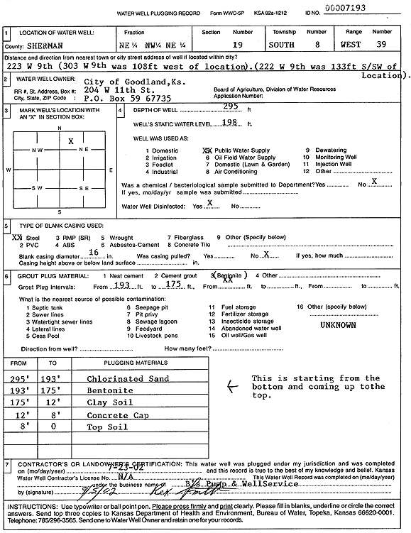
T8S, R39W, Sec. 19 NE NW NE |
City of Goodland | 295 ft. | 198 ft. | Public Water Supply | Plugged | 23-Jul-2002 | Scan | ||
|
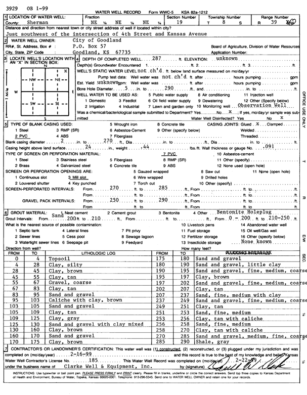
T8S, R39W, Sec. 19 NE NE NE |
City of Goodland | 287 ft. | Monitoring well/observation/piezometer | OB 1-99 | Constructed | 16-Feb-1999 | Scan | ||
|
T8S, R39W, Sec. 19 SW NW NW |
City of Goodland | 284 ft. | 182.03 ft. | Test hole/well | Constructed | 14-Apr-1998 | |||
|
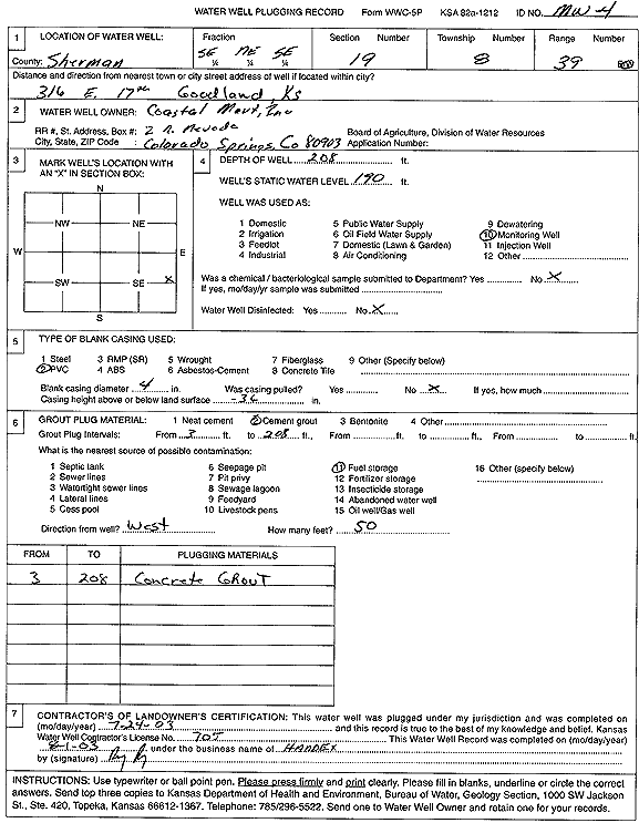
T8S, R39W, Sec. 19 SE NE SE |
Coastal Mart, Inc. | 208 ft. | 189 ft. | Monitoring well/observation/piezometer | MW 4 | Constructed | 20-Mar-2002 | ||
|
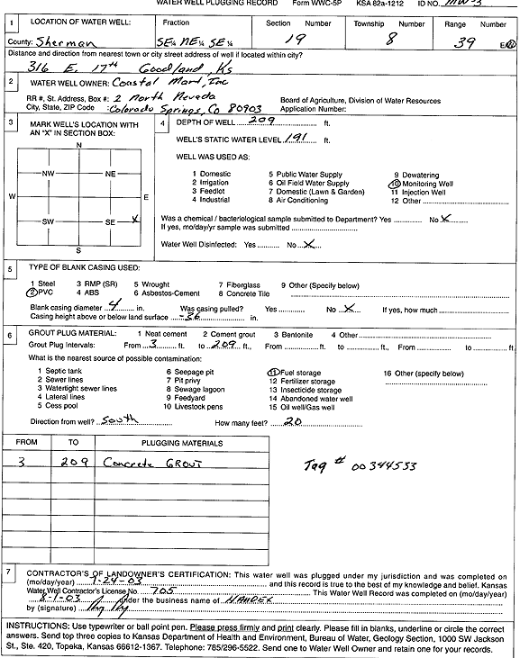
T8S, R39W, Sec. 19 SE NE SE |
Coastal Mart, Inc. | 209 ft. | 191 ft. | Monitoring well/observation/piezometer | MW 3 | Plugged | 24-Jul-2003 | Scan | |
|
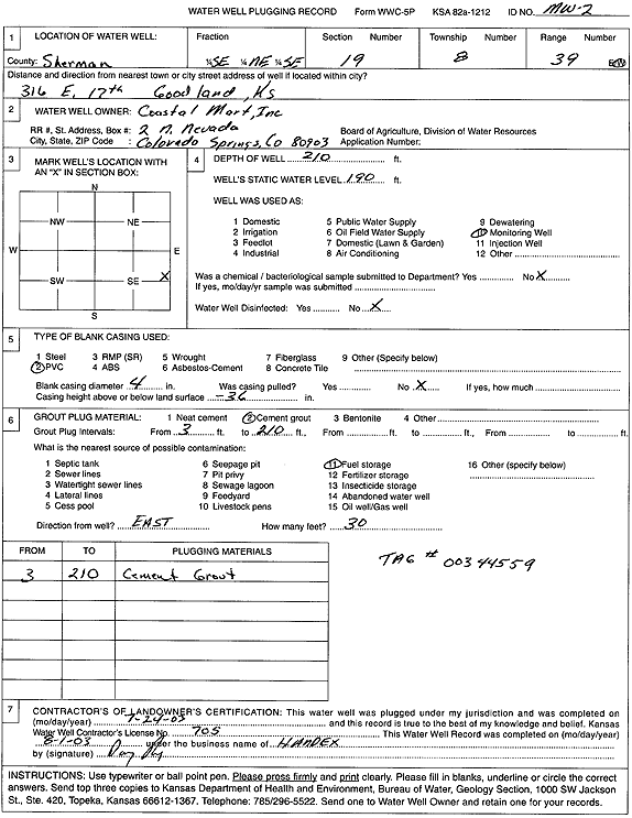
T8S, R39W, Sec. 19 SE NE SE |
Coastal Mart, Inc. | 210 ft. | 190 ft. | Monitoring well/observation/piezometer | MW 2 | Plugged | 24-Jul-2003 | Scan | |
|
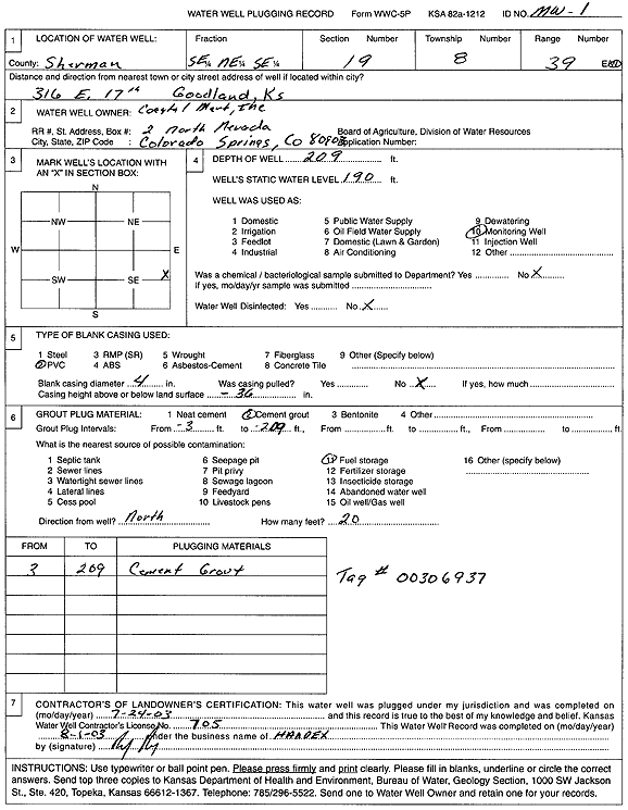
T8S, R39W, Sec. 19 SE NE SE |
Coastal Mart, Inc. | 209 ft. | 190 ft. | Monitoring well/observation/piezometer | MW 1 | Plugged | 24-Jul-2003 | Scan | |
|
T8S, R39W, Sec. 19 SE NE SE |
Coastal Mart, Inc. | 206 ft. | 189 ft. | Monitoring well/observation/piezometer | MW 1 | Constructed | 19-Mar-2002 | ||
|
T8S, R39W, Sec. 19 SE NE SE |
Coastal Mart, Inc. | 210 ft. | 189 ft. | Monitoring well/observation/piezometer | MW 2 | Constructed | 18-Mar-2002 | ||
|
T8S, R39W, Sec. 19 SE NE SE |
Coastal Mart, Inc. | 209 ft. | 189 ft. | Monitoring well/observation/piezometer | MW 3 | Constructed | 20-Mar-2002 | ||
|
T8S, R39W, Sec. 19 SE NE SE |
Coastal Mart, Inc. | 208 ft. | 190 ft. | Monitoring well/observation/piezometer | MW 4 | Plugged | 24-Jul-2003 | Scan | |
|
T8S, R39W, Sec. 19 NE SE NW SE |
Coranco Great Plains, Inc. | 203.17 ft. | 203.17 ft. | Monitoring well/observation/piezometer | MW 3 | Plugged | 26-Oct-2017 |
KOLAR |
|
|
T8S, R39W, Sec. 19 NE SE NW SE |
Coranco Great Plains, Inc. | 203.85 ft. | 203.85 ft. | Monitoring well/observation/piezometer | MW 2 | Plugged | 26-Oct-2017 |
KOLAR |
|
|
T8S, R39W, Sec. 19 NE NE NE |
Dave's Auto Repair | 210 ft. | 187.69 ft. | Monitoring well/observation/piezometer | Constructed | 13-Nov-1997 | |||
|
T8S, R39W, Sec. 19 NE NE NE |
Dave's Auto Repair | 210 ft. | 188.75 ft. | Monitoring well/observation/piezometer | MW 3 | Constructed | 13-Nov-1997 | ||
|
T8S, R39W, Sec. 19 NW NE NE |
Dave's Auto Repair | 191.65 ft. | Monitoring well/observation/piezometer | MW 5 | Plugged | 05-Oct-2006 | |||
|
T8S, R39W, Sec. 19 NW NE NE |
Dave's Auto Repair | 208.05 ft. | 196.1 ft. | Monitoring well/observation/piezometer | MW 2 | Plugged | 05-Oct-2006 | ||
|
T8S, R39W, Sec. 19 NW NE NE |
Dave's Auto Repair | 205 ft. | 187.32 ft. | Monitoring well/observation/piezometer | MW 1 | Constructed | 17-Sep-1997 | ||
|
T8S, R39W, Sec. 19 NW NE NE |
Dave's Auto Repair | 205 ft. | 189.63 ft. | Monitoring well/observation/piezometer | MW 7 | Constructed | 17-Sep-1997 | ||
|
T8S, R39W, Sec. 19 NW NE NE |
Dave's Auto Repair | 210 ft. | 191.27 ft. | Monitoring well/observation/piezometer | MW 2 | Constructed | 12-Nov-1997 | ||
|
T8S, R39W, Sec. 19 NW NE NE |
Dave's Auto Repair | 205 ft. | 190.11 ft. | Monitoring well/observation/piezometer | MW 5 | Constructed | 16-Sep-1997 | ||
|
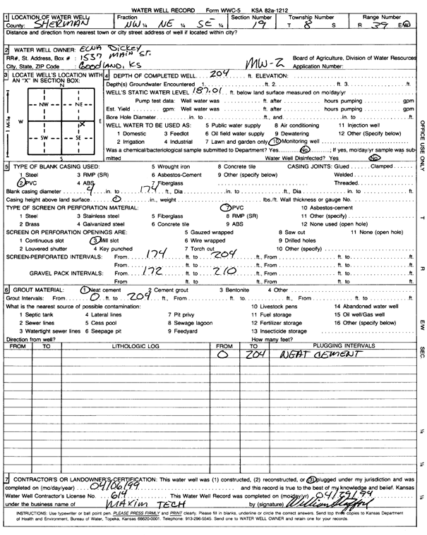
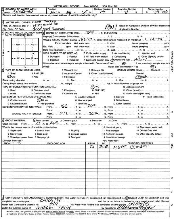
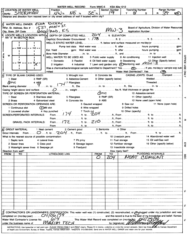
T8S, R39W, Sec. 19 NW NE SE |
Dickey, Elna | 204 ft. | 187.01 ft. | Monitoring well/observation/piezometer | MW 2 | Plugged | 06-Apr-1999 | Scan | |
|
T8S, R39W, Sec. 19 NW NE SE |
Dickey, Elna | 202 ft. | 186.77 ft. | Monitoring well/observation/piezometer | MW 1 | Constructed | 12-Jan-1995 | ||
|
T8S, R39W, Sec. 19 NW NE SE |
Dickey, Elna | 202 ft. | 186.77 ft. | Monitoring well/observation/piezometer | MW 1 | Plugged | 06-Apr-1999 | Scan | |
|
T8S, R39W, Sec. 19 NW NE SE |
Dickey, Elna | 204 ft. | 178 ft. | Monitoring well/observation/piezometer | MW 3 | Plugged | 06-Apr-1999 | Scan | |
|
T8S, R39W, Sec. 19 NW NE SE |
Dickey, Elna | 204 ft. | 187.01 ft. | Monitoring well/observation/piezometer | MW 2 | Constructed | 27-Jan-1995 | ||
|
T8S, R39W, Sec. 19 NW NE SE |
Dickey, Elna | 204 ft. | Monitoring well/observation/piezometer | MW 3 | Constructed | 29-Jan-1995 | |||
|
T8S, R39W, Sec. 19 SW SW SW |
Foust Supply Co. | 221 ft. | 182 ft. | Domestic | Plugged | 09-Aug-1983 | |||
|
T8S, R39W, Sec. 19 NW NE NE |
Jerry's Alignment | 210 ft. | 188.99 ft. | Monitoring well/observation/piezometer | MW 9 | Constructed | 18-Sep-1997 | ||
| View page: < Prev || 11 || 12 || 13 || 14 || 15 || 16 || 17 || 18 || 19 || 20 || Next > | |||||||||