Select location of well to view details.
Click on column heading to sort.
|
|
|
County: Finney Select location of well to view details. Click on column heading to sort. |
|
|
|
| View page: < Prev || 81 || 82 || 83 || 84 || 85 || 86 || 87 || 88 || 89 || 90 || Next > | |||||||||
| T-R-S | Owner | Well Depth Ascend. Desc. |
Static Water Level Ascend. Desc. |
Est. Yield Ascend. Desc. |
Well Use | Other ID | Action Taken | Completion Date Ascend. Desc. |
Scan? |
|
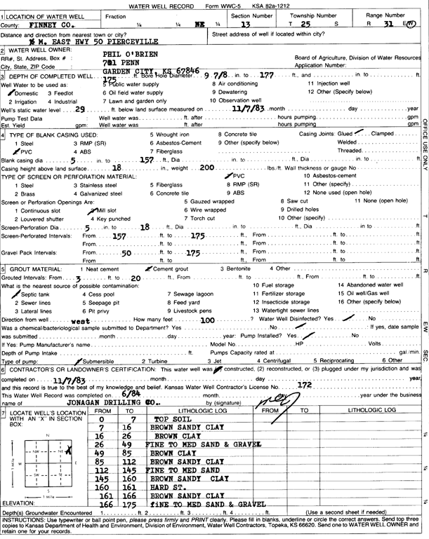
T25S, R31W, Sec. 13 NE |
O'Brien, Phil | 175 ft. | 29 ft. | Domestic | Constructed | 07-Nov-1983 | Scan | ||
|
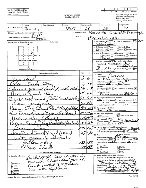
T25S, R31W, Sec. 13 NE |
Pierceville Church and Parsonage | 175 ft. | 16 ft. | Domestic | Constructed | 04-Mar-1975 | Scan | ||
|
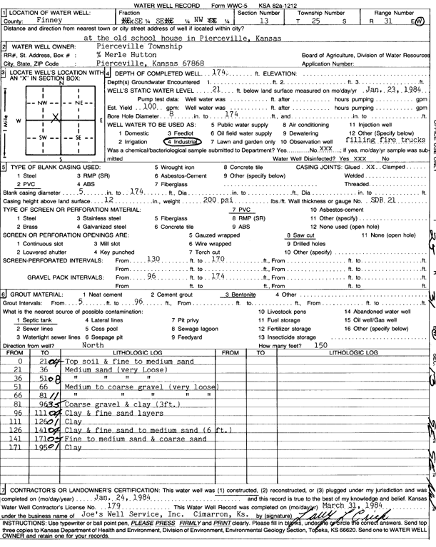
T25S, R31W, Sec. 13 SE SE NW |
Pierceville Township | 174 ft. | 21 ft. | 100 gpm. | Industrial | Constructed | 24-Jan-1984 | Scan | |
|
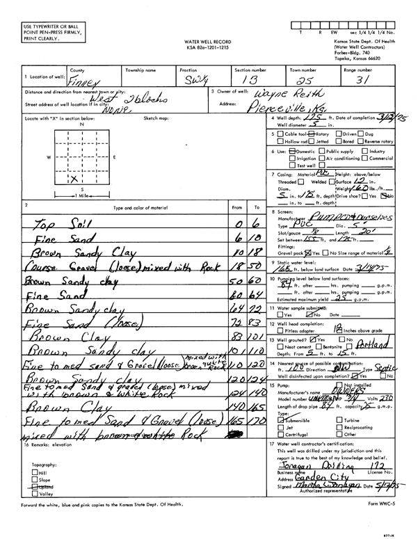
T25S, R31W, Sec. 13 SW |
Reith, Wayne | 175 ft. | 16.5 ft. | 25 gpm. | Domestic | Constructed | 13-Mar-1975 | Scan | |
|
T25S, R31W, Sec. 13 SW NW NE |
Ryman, Jason | 203 ft. | 76.5 ft. | 30 gpm. | Domestic | Constructed | 22-Jun-2010 | ||
|
T25S, R31W, Sec. 13 NW NW SE |
Salazar, Salvador | 204 ft. | 25 ft. | 60 gpm. | Domestic | Constructed | 06-Sep-2002 | Scan | |
|
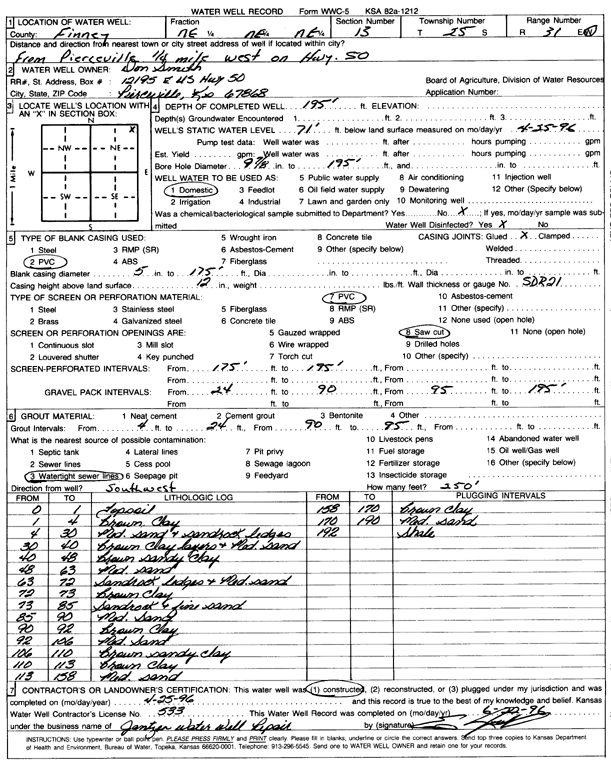
T25S, R31W, Sec. 13 NE NE NE |
Smith, Don | 195 ft. | 71 ft. | Domestic | Constructed | 25-Apr-1996 | Scan | ||
|
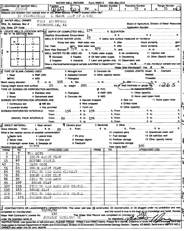
T25S, R31W, Sec. 13 NW |
Snodgrass, Fred | 174 ft. | 25 ft. | Domestic | Constructed | 26-Oct-1982 | Scan | ||
|
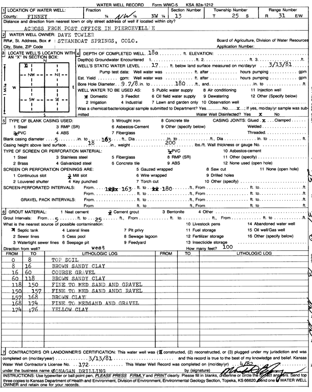
T25S, R31W, Sec. 13 NW |
Towler, Dave | 180 ft. | 17 ft. | Domestic | Constructed | 13-Mar-1981 | Scan | ||
|
T25S, R31W, Sec. 13 SE SE NW |
Walker, Darrell | 165 ft. | 24 ft. | Domestic | Constructed | 20-Feb-1992 | Scan | ||
|
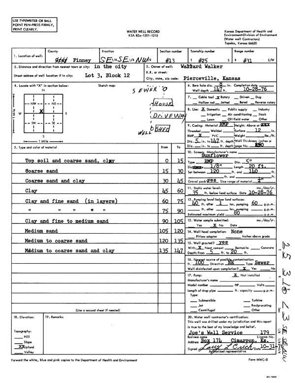
T25S, R31W, Sec. 13 SE SE NW |
Walker, Wallard | 147 ft. | 35 ft. | 80 gpm. | Domestic | Constructed | 28-Oct-1976 | Scan | |
|
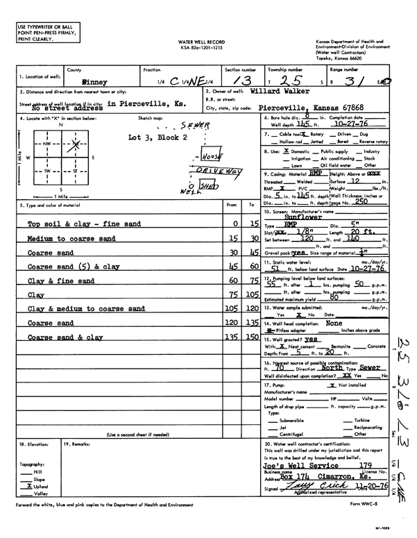
T25S, R31W, Sec. 13 C NE |
Walker, Willard | 145 ft. | 51 ft. | 80 gpm. | Domestic | Constructed | 27-Oct-1976 | Scan | |
|
T25S, R31W, Sec. 13 NE SW NW |
Warner, Vyrl | 164 ft. | 72 ft. | 30 gpm. | Domestic | Constructed | 18-Sep-2024 |
KOLAR |
|
|
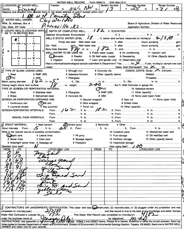
T25S, R31W, Sec. 13 NW |
Weldon, Clay | 182 ft. | 18 ft. | Domestic | Constructed | 03-Feb-1981 | Scan | ||
|
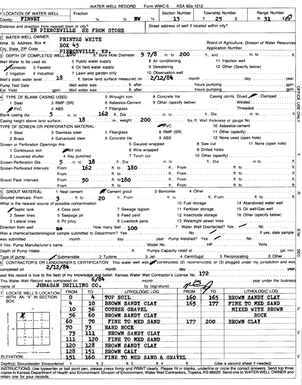
T25S, R31W, Sec. 13 NW |
White, Printes | 180 ft. | 18 ft. | Domestic | Constructed | 12-Feb-1984 | Scan | ||
|
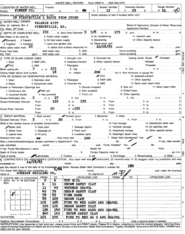
T25S, R31W, Sec. 13 NW |
Witt, Valerie | 172 ft. | 20 ft. | Domestic | Constructed | 28-Oct-1983 | Scan | ||
|
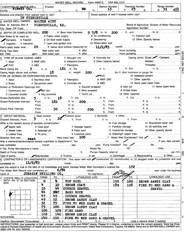
T25S, R31W, Sec. 13 NW |
Witt, Walter | 200 ft. | 20 ft. | Domestic | Constructed | 02-Nov-1983 | Scan | ||
|
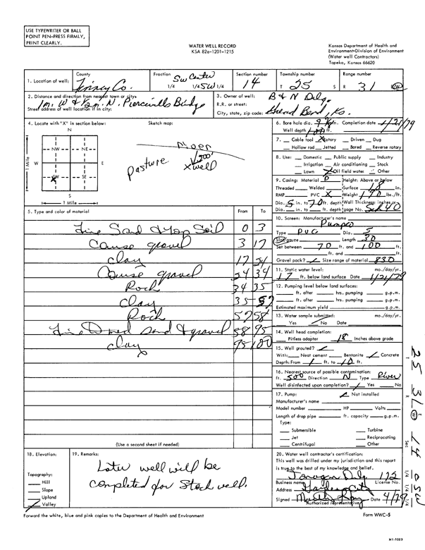
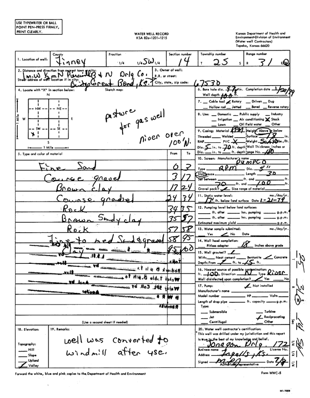
T25S, R31W, Sec. 14 C SW |
B & N Drilling Co. | 100 ft. | 17 ft. | Oil Field Water Supply | Constructed | 21-Jan-1979 | Scan | ||
|
T25S, R31W, Sec. 14 SW |
B & N Drilling Co. | 100 ft. | 17 ft. | Domestic, Livestock | Constructed | 21-Jan-1979 | Scan | ||
|
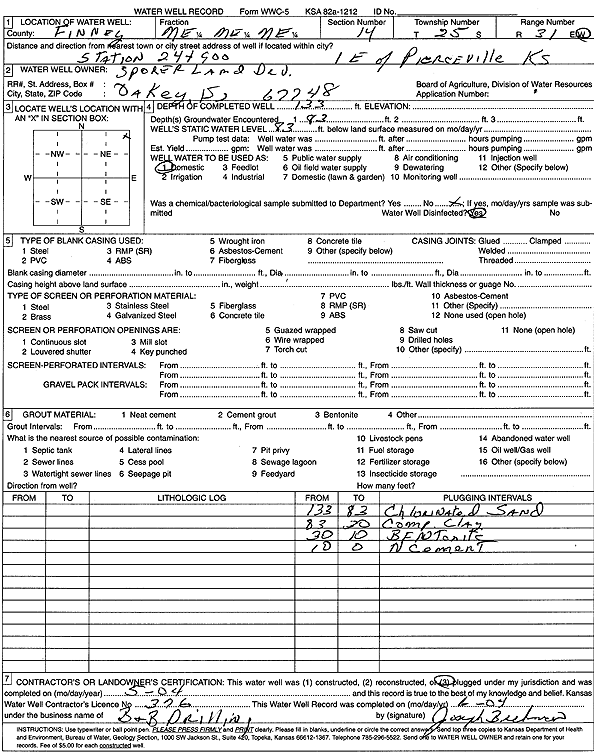
T25S, R31W, Sec. 14 NE NE NE |
Sporer Land Development | 133 ft. | 83 ft. | Domestic | Plugged | 01-May-2004 | Scan | ||
|
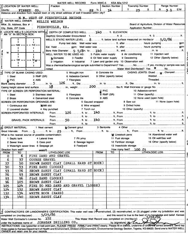
T25S, R31W, Sec. 14 SE |
Weldon, Nellie | 140 ft. | 8 ft. | Domestic | Constructed | 25-May-1986 | Scan | ||
|
T25S, R31W, Sec. 15 SW NE SW |
American Warrior, Inc. | 200 ft. | 68 ft. | Oil Field Water Supply | Constructed | 14-May-2014 | |||
|
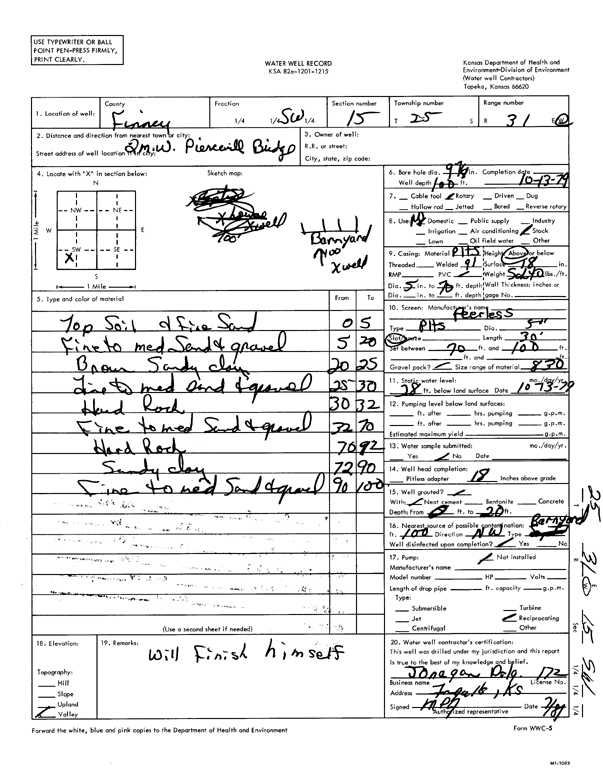
T25S, R31W, Sec. 15 SW |
100 ft. | 28 ft. | Domestic, Livestock | Constructed | 13-Oct-1979 | Scan | |||
|
T25S, R31W, Sec. 16 NE SW NE |
Corley, Dale | 209 ft. | 10 ft. | 1450 gpm. | Irrigation | Constructed | 22-Dec-1976 | Scan | |
|
T25S, R31W, Sec. 16 NW |
Goetz, Laverne | 184 ft. | 12 ft. | 1500 gpm. | Irrigation | Constructed | 14-Jul-1976 | Scan | |
|
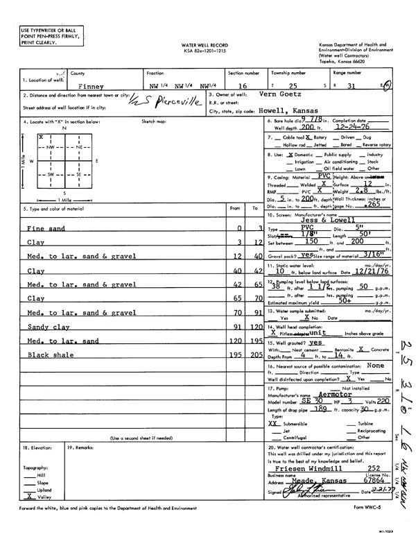
T25S, R31W, Sec. 16 NW NW NW |
Goetz, Vern | 200 ft. | 10 ft. | 50 gpm. | Domestic | Constructed | 24-Dec-1976 | Scan | |
|
T25S, R31W, Sec. 17 NE |
Goetz, Lavern | 215 ft. | 38 ft. | 1600 gpm. | Irrigation | Constructed | 14-Jul-1976 | Scan | |
|
T25S, R31W, Sec. 17 SE |
Goetz, Laverne | 199 ft. | 43 ft. | 1450 gpm. | Irrigation | Constructed | 14-Jul-1976 | Scan | |
|
T25S, R31W, Sec. 17 NW SE NW |
Goetz, Laverne | 185 ft. | 30 ft. | 1500 gpm. | Irrigation | Constructed | 14-Jul-1976 | Scan | |
|
T25S, R31W, Sec. 17 SW |
Goetz, Laverne | 226 ft. | 43 ft. | 1500 gpm. | Irrigation | Constructed | 14-Jul-1976 | Scan | |
|
T25S, R31W, Sec. 18 NE NE NW |
Brookover Cattle | 280 ft. | 185 ft. | 30 gpm. | Domestic, Livestock | Constructed | 14-Aug-2024 |
KOLAR |
|
|
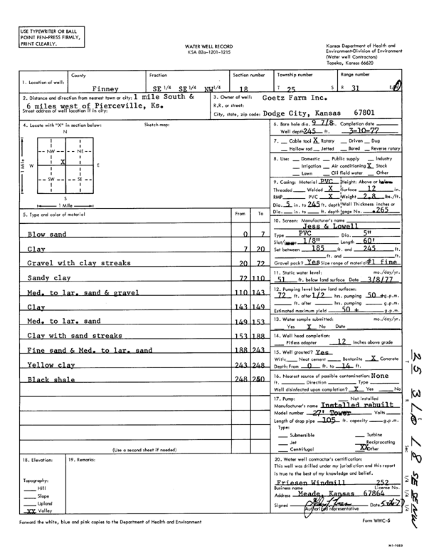
T25S, R31W, Sec. 18 SE SE NW |
Goetz Farm, Inc. | 245 ft. | 51 ft. | 50 gpm. | Domestic, Livestock | Constructed | 10-Mar-1977 | Scan | |
|
T25S, R31W, Sec. 18 SE SW NE |
Goetz, Laverne | 218 ft. | 50 ft. | 1500 gpm. | Irrigation | Constructed | 14-Sep-1976 | Scan | |
|
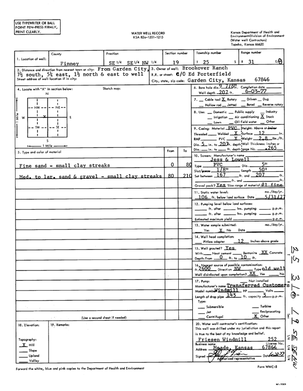
T25S, R31W, Sec. 19 SE SE NW |
Brookover Ranch | 207 ft. | 106 ft. | Domestic, Livestock | Constructed | 03-Jun-1977 | Scan | ||
|
T25S, R31W, Sec. 21 SW SW SW |
Kleysteuber, Dennis | 245 ft. | 80 ft. | Domestic, Livestock | Constructed | 30-Jul-1976 | Scan | ||
|
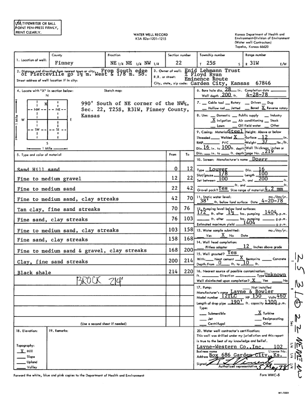
T25S, R31W, Sec. 22 NE NE NW |
Enid Lehmann Trust | 200 ft. | 38 ft. | 1404 gpm. | Irrigation | Constructed | 28-Apr-1978 | Scan | |
|
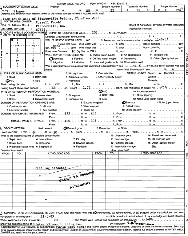
T25S, R31W, Sec. 22 NW |
Proehl, Russell | 205 ft. | 42 ft. | 1700 gpm. | Irrigation | Constructed | 22-Oct-1984 | Scan | |
|
T25S, R31W, Sec. 22 NW |
Proehl, Russell | 203 ft. | 42 ft. | Domestic | Constructed | 08-Nov-1983 | Scan | ||
|
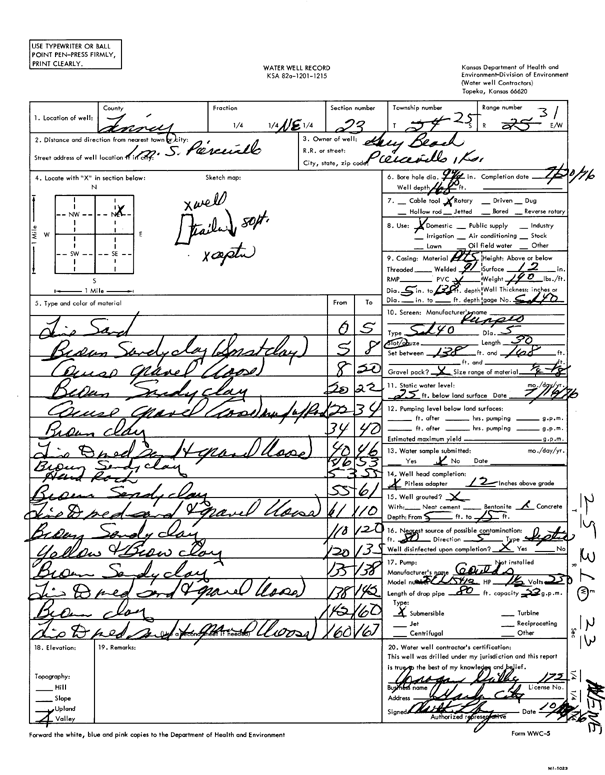
T25S, R31W, Sec. 23 NE |
Beach, Gary | 168 ft. | 25 ft. | Domestic | Constructed | 20-Jul-1976 | Scan | ||
|
T25S, R31W, Sec. 23 SW NE SW |
Beach, Phyllis | 202 ft. | 37 ft. | 1425 gpm. | Irrigation | Constructed | 15-Jul-1976 | Scan | |
|
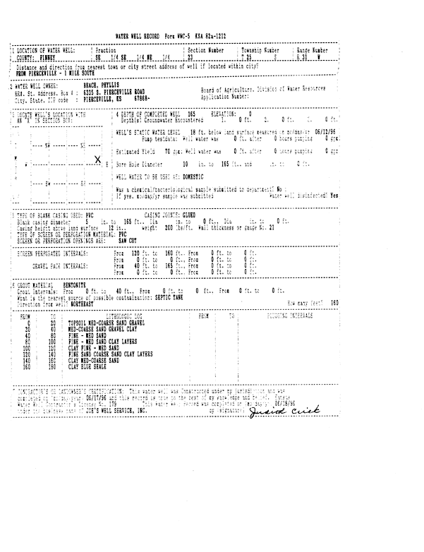
T25S, R31W, Sec. 23 SE SE NE |
Beach, Phyllis | 165 ft. | 18 ft. | 70 gpm. | Domestic | Constructed | 17-Jun-1996 | Scan | |
|
T25S, R31W, Sec. 24 SW NE SW |
Corley, Dale | 180 ft. | 32 ft. | 900 gpm. | Irrigation | Constructed | 19-Dec-1976 | Scan | |
|
T25S, R31W, Sec. 24 SE NW SE |
Corley, Dale | 175 ft. | 21 ft. | 1500 gpm. | Irrigation | Constructed | 10-Dec-1976 | Scan | |
|
T25S, R31W, Sec. 24 SE SE SW |
Nelle Beach Trust | 210 ft. | 59 ft. | Irrigation | Constructed | 16-Mar-2005 | |||
|
T25S, R31W, Sec. 24 SW |
Nelle Beach Trust | 180 ft. | 55 ft. | Irrigation | Plugged | 30-Mar-2005 | |||
|
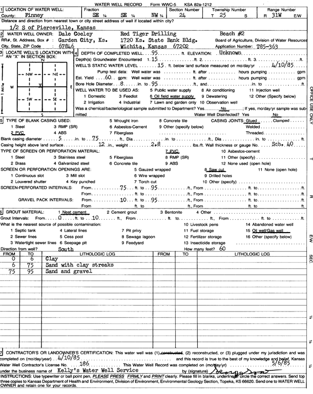
T25S, R31W, Sec. 24 SE SE NW |
Red Tiger Drilling/Dale Corley | 95 ft. | 15 ft. | 60 gpm. | Oil Field Water Supply | Beach 2 | Constructed | 10-Apr-1985 | Scan |
|
T25S, R31W, Sec. 25 NE SW NE |
Corley, Dale | 220 ft. | 36 ft. | 1350 gpm. | Irrigation | Constructed | 21-Dec-1976 | Scan | |
|
T25S, R31W, Sec. 25 SW |
Corley, Dale | 190 ft. | 41 ft. | 1325 gpm. | Irrigation | Constructed | 24-Jun-1976 | Scan | |
|
T25S, R31W, Sec. 25 NW |
Corley, Dale | 235 ft. | 33 ft. | 1400 gpm. | Irrigation | Constructed | 24-Jun-1976 | Scan | |
|
T25S, R31W, Sec. 25 SE |
Corley, Dale | 210 ft. | 45 ft. | 1200 gpm. | Irrigation | Constructed | 28-Dec-1978 | Scan | |
| View page: < Prev || 81 || 82 || 83 || 84 || 85 || 86 || 87 || 88 || 89 || 90 || Next > | |||||||||