Select location of well to view details.
Click on column heading to sort.
|
|
|
County: Finney Select location of well to view details. Click on column heading to sort. |
|
|
|
| View page: < Prev || 81 || 82 || 83 || 84 || 85 || 86 || 87 || 88 || 89 || 90 || Next > | |||||||||
| T-R-S | Owner | Well Depth Ascend. Desc. |
Static Water Level Ascend. Desc. |
Est. Yield Ascend. Desc. |
Well Use | Other ID | Action Taken | Completion Date Ascend. Desc. |
Scan? |
|
T25S, R31W, Sec. 25 C SE |
Nelle Beach Trust | 210 ft. | 88 ft. | Irrigation | Plugged | 02-May-2006 | |||
|
T25S, R31W, Sec. 25 C SE |
Nelle Beach Trust | 220 ft. | 88 ft. | Irrigation | Constructed | 27-Mar-2006 | |||
|
T25S, R31W, Sec. 26 SE NW SE |
Beach, Phyllis | 196 ft. | 52 ft. | 1400 gpm. | Irrigation | Constructed | 15-Jul-1976 | Scan | |
|
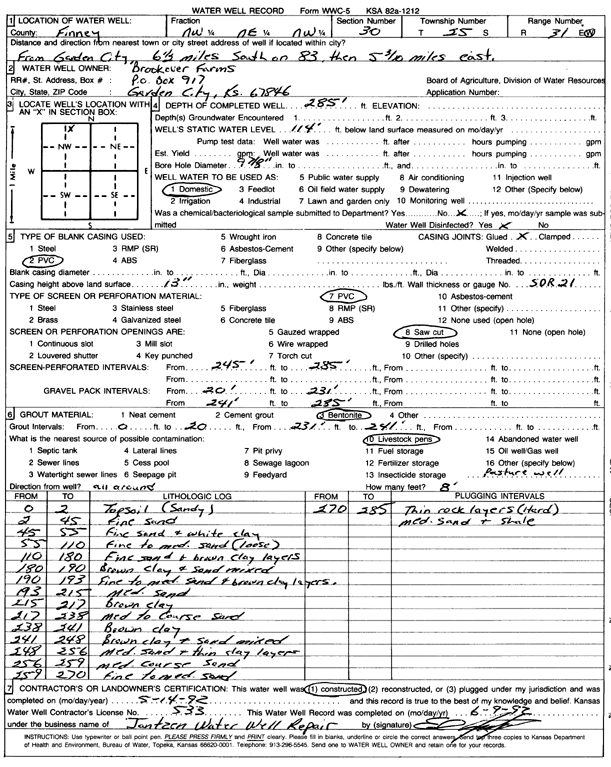
T25S, R31W, Sec. 30 NW NE NW |
Brookover Farms | 285 ft. | 114 ft. | Domestic | Constructed | 14-May-1992 | Scan | ||
|
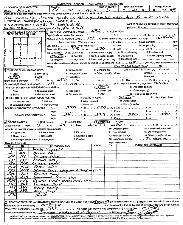
T25S, R31W, Sec. 31 SE SE NE |
D. Lightner Farms, Inc. | 290 ft. | 114 ft. | Domestic | Constructed | 09-Oct-2000 | Scan | ||
|
T25S, R31W, Sec. 31 C SE |
Lightner, Dale | 295 ft. | 59 ft. | Irrigation | Constructed | 03-Mar-1976 | Scan | ||
|
T25S, R31W, Sec. 31 NW SE NW |
Lightner, Gerald | 352 ft. | Irrigation | Constructed | 29-Mar-2012 | ||||
|
T25S, R31W, Sec. 32 SE |
Vanderee, Don | 267 ft. | 78 ft. | 1400 gpm. | Irrigation | Constructed | 29-Jan-1979 | Scan | |
|
T25S, R31W, Sec. 33 SW NE SW |
Beach, Phyllis | 232 ft. | 69 ft. | 1325 gpm. | Irrigation | Constructed | 15-Jul-1976 | Scan | |
|
T25S, R31W, Sec. 33 SE NW SE |
Beach, Phyllis | 217 ft. | 63 ft. | 1400 gpm. | Irrigation | Constructed | 15-Jul-1976 | Scan | |
|
T25S, R31W, Sec. 34 SW NE SW NE |
Finnup Foundation Trust | 252 ft. | 158 ft. | 808 gpm. | Irrigation | Constructed | 04-Dec-2015 |
KOLAR |
|
|
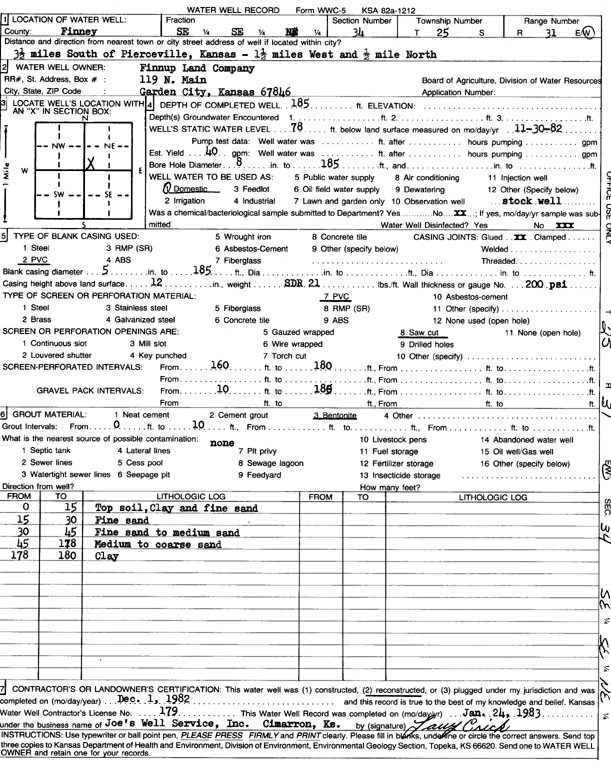
T25S, R31W, Sec. 34 SE SE NE |
Finnup Land Company | 185 ft. | 78 ft. | 40 gpm. | Domestic, Livestock | Reconstructed | 01-Dec-1982 | Scan | |
|
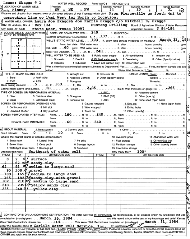
T25S, R31W, Sec. 34 NW NE NW |
Skaggs, Laura Joe and Joe Karrie | 240 ft. | 103 ft. | 60 gpm. | Oil Field Water Supply | Constructed | 29-Mar-1984 | Scan | |
|
T25S, R31W, Sec. 34 NW NW SW |
Thiessen, Johan | 323 ft. | 179 ft. | 300 gpm. | Irrigation | Constructed | 04-Sep-2024 |
KOLAR |
|
|
T25S, R31W, Sec. 35 NW SW NW SE |
Bar-O-Bar Ranch | 266 ft. | 160 ft. | 300 gpm. | Irrigation | Constructed | 03-Jan-2022 |
KOLAR |
|
|
T25S, R31W, Sec. 35 NE SW NE |
Beach, Phyllis | 273 ft. | 76 ft. | 1450 gpm. | Irrigation | Constructed | 15-Jul-1976 | Scan | |
|
T25S, R31W, Sec. 35 SW NE SW |
Beach, Phyllis | 285 ft. | 84 ft. | 1200 gpm. | Irrigation | Constructed | 15-Jul-1976 | Scan | |
|
T25S, R31W, Sec. 36 SW NE SW |
Corley, Dale | 238 ft. | 66 ft. | 1500 gpm. | Irrigation | Constructed | 22-Dec-1976 | Scan | |
|
T25S, R31W, Sec. 36 SE |
Corley, Dale | 242 ft. | 66 ft. | 1400 gpm. | Irrigation | Constructed | 24-Jun-1976 | Scan | |
|
T25S, R31W, Sec. 36 NE |
Corley, Dale | 210 ft. | 41 ft. | 1450 gpm. | Irrigation | Constructed | 24-Jun-1976 | Scan | |
|
T25S, R31W, Sec. 36 NW |
Corley, Dale | 262 ft. | 44 ft. | 1450 gpm. | Irrigation | Constructed | 24-Jun-1976 | Scan | |
|
T25S, R31W, Sec. 36 SW NE NE |
Gillen, Dale J. | 200 ft. | 89.5 ft. | Domestic, Livestock | Constructed | 10-Nov-1988 | Scan | ||
|
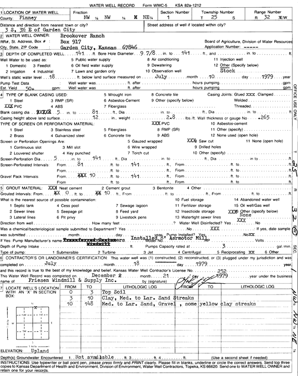
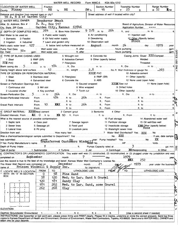
T25S, R32W, Sec. 1 NW NW NE |
Brookover Ranch | 141 ft. | 18 ft. | 50 gpm. | Domestic, Livestock | Constructed | 18-Jul-1979 | Scan | |
|
T25S, R32W, Sec. 1 NW SE NE |
JBS USA | 52.8 ft. | 21.2 ft. | Monitoring well/observation/piezometer | MW 26 | Plugged | 07-May-2019 | ||
|
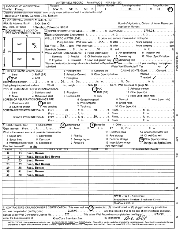
T25S, R32W, Sec. 1 NW SE NE |
Monfort, Inc. | 50 ft. | Monitoring well/observation/piezometer | MW 26 | Constructed | 25-Feb-1999 | Scan | ||
|
T25S, R32W, Sec. 2 NE NE NE NE |
Brookover Feed Yard | 257 ft. | 105 ft. | 1690 gpm. | Irrigation | Constructed | 03-Jun-2019 |
KOLAR |
|
|
T25S, R32W, Sec. 2 NE SE NW |
JBS USA | 75 ft. | 60.15 ft. | Monitoring well/observation/piezometer | MW 24 | Plugged | 07-May-2019 | ||
|
T25S, R32W, Sec. 2 NE SE NW |
Monfort, Inc. | 75 ft. | Monitoring well/observation/piezometer | MW 24 | Constructed | 24-Feb-1999 | |||
|
T25S, R32W, Sec. 3 NW NW SW |
Oxy USA, Inc. | 320 ft. | 120 ft. | 90 gpm. | Oil Field Water Supply | MPC 1 A | Constructed | 21-Dec-2010 | |
|
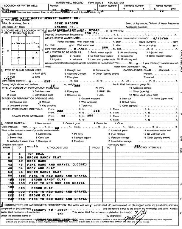
T25S, R32W, Sec. 4 SE NE NE |
Hadgen, Gene | 258 ft. | 70 ft. | Domestic | Constructed | 10-Jan-1991 | Scan | ||
|
T25S, R32W, Sec. 5 NW NE SW |
Brookover Ranch | 320 ft. | 182 ft. | 40 gpm. | Domestic, Livestock | Constructed | 29-Jun-2022 | ||
|
T25S, R32W, Sec. 6 SW SW NE |
Brookover Ranch | 340 ft. | 193 ft. | 50 gpm. | Domestic, Livestock | Constructed | 24-Sep-2025 |
KOLAR |
|
|
T25S, R32W, Sec. 6 NE NW SE |
City of Garden City | 353 ft. | 120 ft. | 1800 gpm. | Public Water Supply | Constructed | 07-Jun-1991 | Scan | |
|
T25S, R32W, Sec. 6 NW NW SE |
City of Garden City | 347 ft. | 75 ft. | 100 gpm. | Monitoring well/observation/piezometer | Constructed | 17-Aug-1990 | Scan | |
|
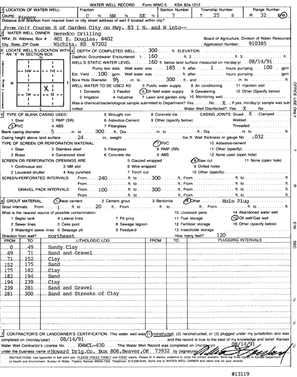
T25S, R32W, Sec. 7 C NW SE |
Beredco Drilling | 300 ft. | 160 ft. | 100 gpm. | Oil Field Water Supply | Constructed | 14-Aug-1991 | Scan | |
|
T25S, R32W, Sec. 7 SW NE SW |
Brookover Feedlot | 475 ft. | 114 ft. | 1500 gpm. | Irrigation | Constructed | 20-Sep-1976 | ||
|
T25S, R32W, Sec. 7 SW |
Northern Pump Co. | 260 ft. | 115 ft. | 100 gpm. | Oil Field Water Supply | Brookover 7-1 | Constructed | 31-Jul-1986 | Scan |
|
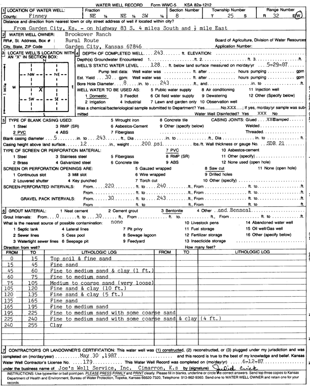
T25S, R32W, Sec. 8 NE NE SW |
Brookover Ranch | 243 ft. | 128 ft. | 30 gpm. | Domestic | Constructed | 30-May-1987 | Scan | |
|
T25S, R32W, Sec. 8 SE NW NW |
EOG Resources Inc | 300 ft. | 163 ft. | 100 gpm. | Oil Field Water Supply | Brookover 8 1 | Constructed | 23-Mar-2010 | |
|
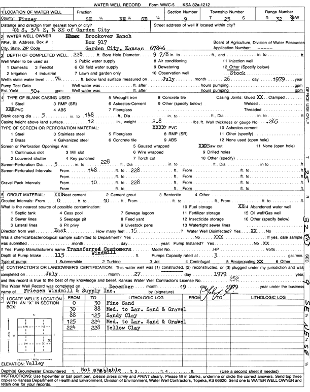
T25S, R32W, Sec. 9 SE NE SE |
Brookover Ranch | 228 ft. | 74 ft. | 50 gpm. | Domestic, Livestock | Constructed | 27-Jul-1979 | Scan | |
|
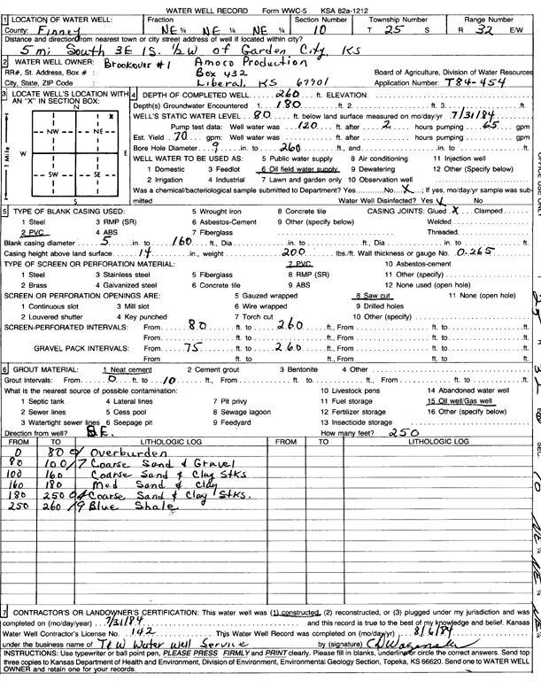
T25S, R32W, Sec. 10 NE NE NE |
Amoco Production | 260 ft. | 80 ft. | 70 gpm. | Oil Field Water Supply | Brookover 1 | Constructed | 31-Jul-1984 | Scan |
|
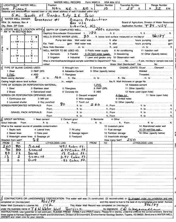
T25S, R32W, Sec. 10 NE NE NE |
Amoco Production | 260 ft. | 80 ft. | Oil Field Water Supply | Brookover 1 | Plugged | 15-Aug-1984 | Scan | |
|
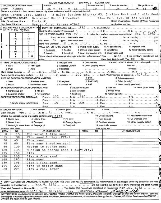
T25S, R32W, Sec. 10 SE SE SE |
Brookover Ranch & Feeders | 225 ft. | 90 ft. | 40 gpm. | Domestic | Well 1 SW of office | Constructed | 08-May-1985 | Scan |
|
T25S, R32W, Sec. 12 NE SE NW |
Brookover | 269 ft. | 56 ft. | 2150 gpm. | Irrigation | Constructed | 26-Apr-1977 | Scan | |
|
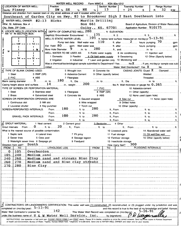
T25S, R32W, Sec. 13 SW SE NE |
Murfin Drilling Co. | 280 ft. | 105 ft. | 80 gpm. | Oil Field Water Supply | Hicks 2-13 | Constructed | 13-May-1991 | Scan |
|
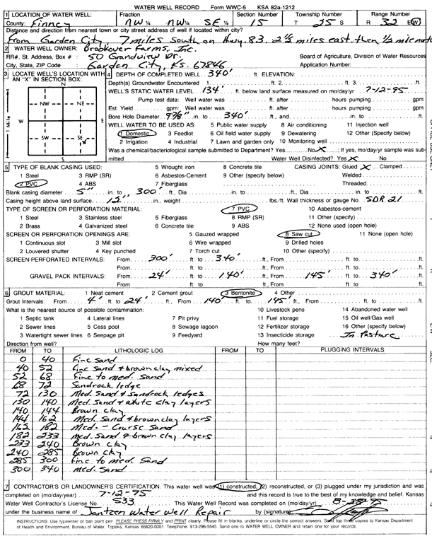
T25S, R32W, Sec. 15 NW NW SE |
Brookover Farms, Inc. | 340 ft. | 134 ft. | Domestic | Constructed | 12-Jul-1995 | Scan | ||
|
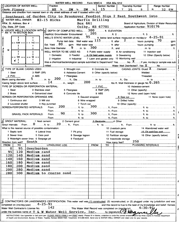
T25S, R32W, Sec. 15 NE SW SW |
Murfin Drilling Co. | 300 ft. | 95 ft. | 80 gpm. | Oil Field Water Supply | Hicks 2-15 | Constructed | 25-Apr-1991 | Scan |
|
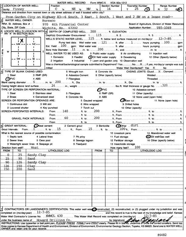
T25S, R32W, Sec. 16 C NE NW |
Berexco | 200 ft. | 115 ft. | 100 gpm. | Oil Field Water Supply | Constructed | 07-Dec-1985 | Scan | |
|
T25S, R32W, Sec. 16 NE NE SW |
Brookover Ranch | 264 ft. | 127 ft. | 50 gpm. | Domestic, Livestock | Constructed | 07-Sep-1979 | Scan | |
|
T25S, R32W, Sec. 17 NW SE NW |
Brookover Feedlot | 437 ft. | 101 ft. | 1550 gpm. | Irrigation | Constructed | 30-Aug-1976 | Scan | |
| View page: < Prev || 81 || 82 || 83 || 84 || 85 || 86 || 87 || 88 || 89 || 90 || Next > | |||||||||