Select location of well to view details.
Click on column heading to sort.
|
|
|
County: Finney Select location of well to view details. Click on column heading to sort. |
|
|
|
| View page: < Prev || 31 || 32 || 33 || 34 || 35 || 36 || 37 || 38 || 39 || 40 || Next > | |||||||||
| T-R-S | Owner | Well Depth Ascend. Desc. |
Static Water Level Ascend. Desc. |
Est. Yield Ascend. Desc. |
Well Use | Other ID | Action Taken | Completion Date Ascend. Desc. |
Scan? |
|
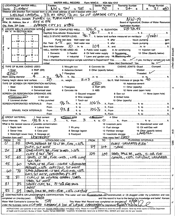
T24S, R31W, Sec. 20 NW SW SE |
Finney County Public Works | 106.5 ft. | 96.7 ft. | Monitoring well/observation/piezometer | MW 19 | Constructed | 26-Jan-2001 | Scan | |
|
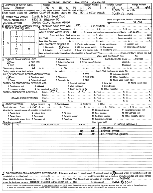
T24S, R31W, Sec. 20 NE NE SW |
Irsik and Doll Feedyard | 295 ft. | 136 ft. | Feedlot | Plugged | 06-Sep-1996 | Scan | ||
|
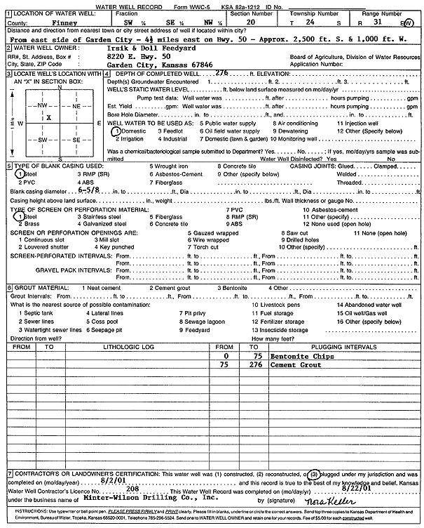
T24S, R31W, Sec. 20 SW SE NW |
Irsik and Doll Feedyard | 276 ft. | Domestic | Plugged | 02-Aug-2001 | Scan | |||
|
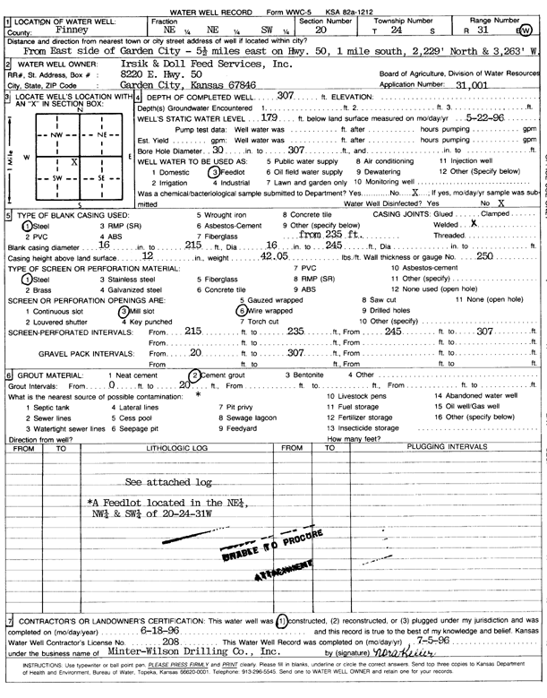
T24S, R31W, Sec. 20 NE NE SW |
Irsik and Doll Feedyard | 307 ft. | 179 ft. | Feedlot | Constructed | 18-Jun-1996 | Scan | ||
|
T24S, R31W, Sec. 21 SE SW SW |
Kisner, Ray | 313 ft. | 157 ft. | Irrigation | Constructed | 23-Feb-1999 | Scan | ||
|
T24S, R31W, Sec. 21 NW SW SE |
Zegler, Patty | 299 ft. | 154 ft. | Irrigation | Constructed | 11-Mar-2003 | Scan | ||
|
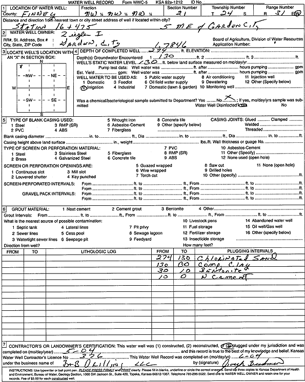
T24S, R31W, Sec. 21 NW NW NW |
Ziegler I | 274 ft. | 130 ft. | Irrigation | Plugged | 01-May-2004 | Scan | ||
|
T24S, R31W, Sec. 22 NW NW SE |
Harms, Roy and Janice | 310 ft. | 182 ft. | Irrigation | Constructed | 23-Jan-2014 | |||
|
T24S, R31W, Sec. 23 NE SE SW |
Ingalls Feed Yard | 331 ft. | 142 ft. | 1400 gpm. | Irrigation | Constructed | 11-Dec-1980 | Scan | |
|
T24S, R31W, Sec. 23 SE NE SE |
Ingalls Feed Yard | 282 ft. | 177 ft. | Irrigation | Constructed | 18-Aug-1975 | Scan | ||
|
T24S, R31W, Sec. 23 SE NW NW |
Irsik and Sons, Inc. | 278 ft. | 162 ft. | 1130 gpm. | Irrigation | Constructed | 03-May-1996 | Scan | |
|
T24S, R31W, Sec. 26 NW |
Dechant, Jake | 266 ft. | 136 ft. | Domestic | Constructed | 07-Oct-1981 | Scan | ||
|
T24S, R31W, Sec. 27 SE NW SW |
Garden City Municipal Airport | 227 ft. | 143 ft. | Public Water Supply | Constructed | 29-Jan-1992 | Scan | ||
|
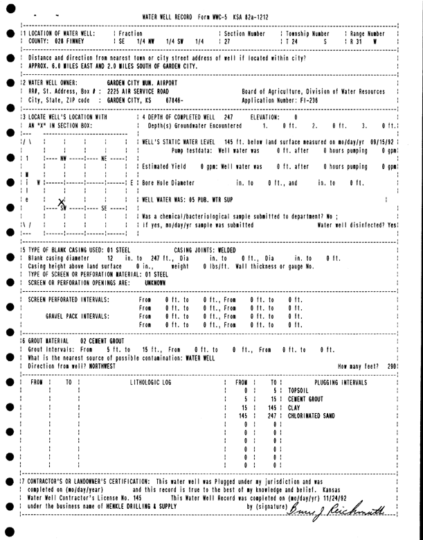
T24S, R31W, Sec. 27 SE NW SW |
Garden City Municipal Airport | 247 ft. | 145 ft. | Public Water Supply | Plugged | 24-Nov-1992 | Scan | ||
|
T24S, R31W, Sec. 27 NW NW NW |
Moler, John | 338 ft. | 135 ft. | Irrigation | Constructed | 10-Mar-1976 | Scan | ||
|
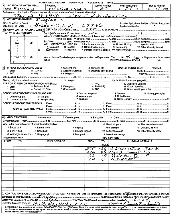
T24S, R31W, Sec. 27 SW SW SW |
Ziegler II | 275 ft. | 136 ft. | Irrigation | Plugged | 01-May-2004 | Scan | ||
|
T24S, R31W, Sec. 27 N2 E2 SW |
Ziegler, Patty | 283 ft. | 150 ft. | Irrigation | Constructed | 05-Mar-2003 | Scan | ||
|
T24S, R31W, Sec. 29 NW SE NE |
Morris, Raymond | 340 ft. | 151 ft. | 1500 gpm. | Irrigation | Constructed | 28-Dec-1977 | Scan | |
|
T24S, R31W, Sec. 30 NW NW SW |
Atkinson, Nolan | 230 ft. | 130 ft. | Domestic | Constructed | 26-Aug-1976 | Scan | ||
|
T24S, R31W, Sec. 30 SE SW NW |
BFI of Western Kansas | 540 ft. | 207 ft. | Industrial | Constructed | 16-Aug-1997 | Scan | ||
|
T24S, R31W, Sec. 30 SE SW NW |
BFI of Western Kansas | 540 ft. | 207 ft. | Industrial | Constructed | 16-Aug-1997 | Scan | ||
|
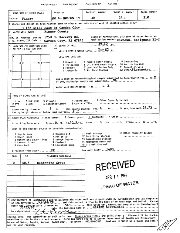
T24S, R31W, Sec. 30 NW NW NW |
Finney County | 39.1 ft. | Monitoring well/observation/piezometer | PZ C | Plugged | 23-Jan-1996 | Scan | ||
|
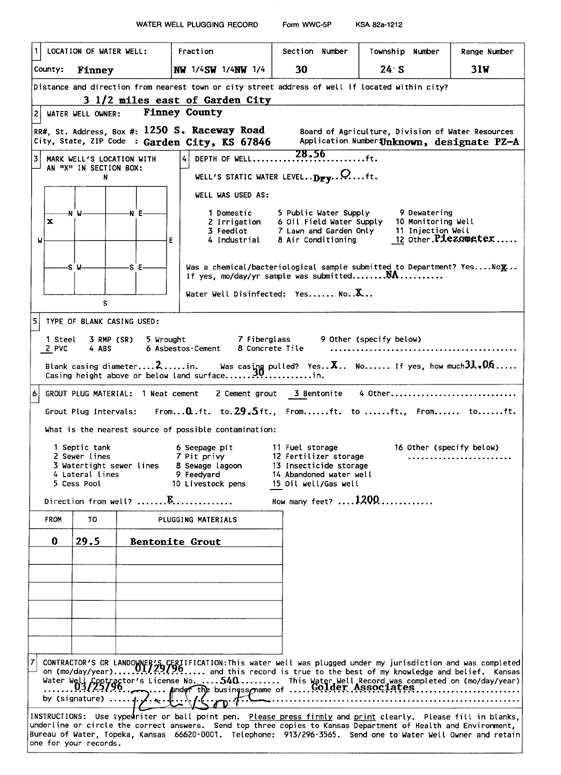
T24S, R31W, Sec. 30 NW SW NW |
Finney County | 28.5 ft. | Monitoring well/observation/piezometer | PZ A | Plugged | 29-Jan-1996 | Scan | ||
|
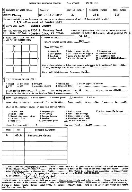
T24S, R31W, Sec. 30 SE NW NW |
Finney County | 30.9 ft. | Monitoring well/observation/piezometer | PZ D | Plugged | 25-Jan-1996 | Scan | ||
|
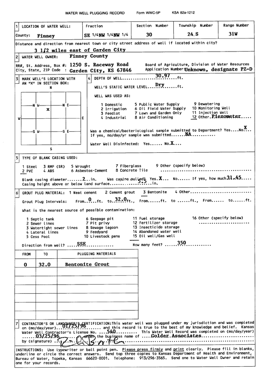
T24S, R31W, Sec. 30 NW SE NW |
Finney County | 37.7 ft. | Monitoring well/observation/piezometer | PZ B | Plugged | 23-Jan-1996 | Scan | ||
|
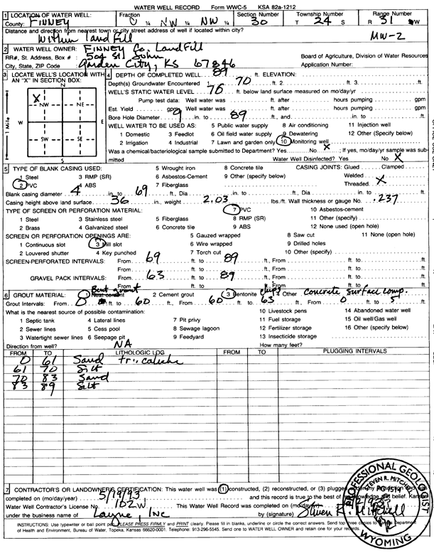
T24S, R31W, Sec. 30 C NW NW |
Finney County Landfill | 89 ft. | 70 ft. | Monitoring well/observation/piezometer | MW 2 | Constructed | 19-May-1993 | Scan | |
|
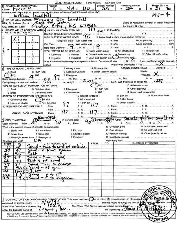
T24S, R31W, Sec. 30 C NW NW |
Finney County Landfill | 119 ft. | 90 ft. | Monitoring well/observation/piezometer | MW 4 | Constructed | 20-May-1993 | Scan | |
|
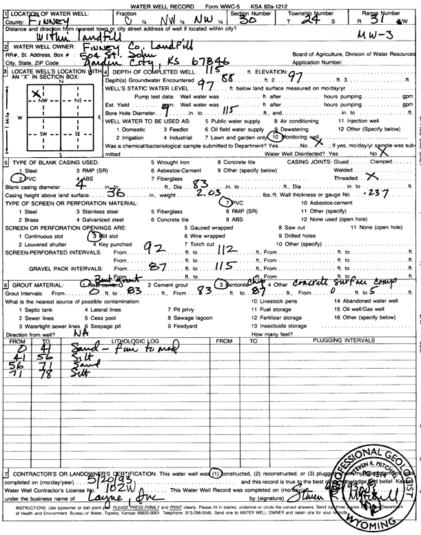
T24S, R31W, Sec. 30 C NW NW |
Finney County Landfill | 115 ft. | 97 ft. | Monitoring well/observation/piezometer | MW 3 | Constructed | 20-May-1993 | Scan | |
|
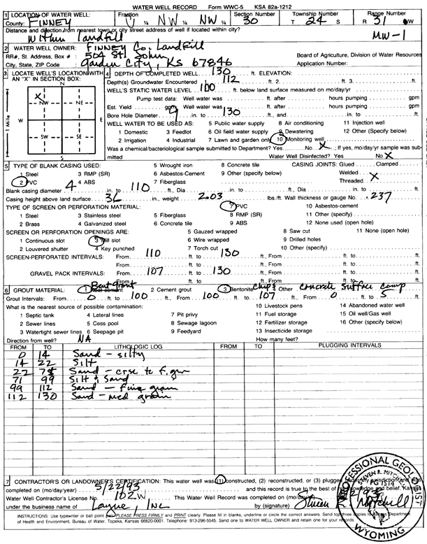
T24S, R31W, Sec. 30 C NW NW |
Finney County Landfill | 130 ft. | 100 ft. | Monitoring well/observation/piezometer | MW 1 | Constructed | 22-May-1993 | Scan | |
|
T24S, R31W, Sec. 30 SE SW NW |
Finney County Landfill | 173.5 ft. | 135.05 ft. | Monitoring well/observation/piezometer | MW 5-RR | Constructed | 26-Jun-2024 |
KOLAR |
|
|
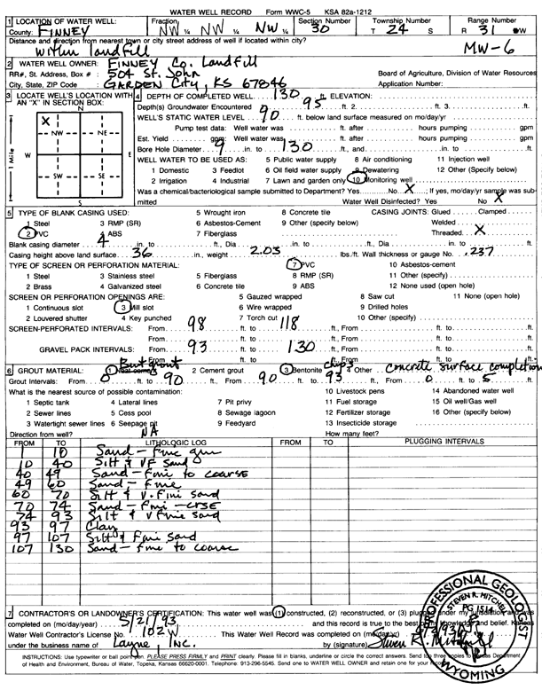
T24S, R31W, Sec. 30 NW NW NW |
Finney County Landfill | 130 ft. | 90 ft. | Monitoring well/observation/piezometer | MW 6 | Constructed | 21-May-1993 | Scan | |
|
T24S, R31W, Sec. 30 NW SW NW |
Finney County Landfill | 160 ft. | 121 ft. | Monitoring well/observation/piezometer | Constructed | 16-Oct-2018 | |||
|
T24S, R31W, Sec. 30 SW SW NW |
Finney County Landfill | 177 ft. | 143.84 ft. | Monitoring well/observation/piezometer | MW 7-RR | Constructed | 27-Jun-2024 |
KOLAR |
|
|
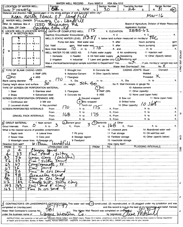
T24S, R31W, Sec. 30 C NC NW |
Finney County Landfill | 175 ft. | 113.51 ft. | Monitoring well/observation/piezometer | MW 16 | Constructed | 17-Oct-1997 | Scan | |
|
T24S, R31W, Sec. 30 NW NW NW |
Finney County Landfill | 156 ft. | 132.58 ft. | Monitoring well/observation/piezometer | MW 1R | Constructed | 30-Sep-2016 | ||
|
T24S, R31W, Sec. 30 NE NW NW |
Finney County Landfill | 147 ft. | 125.5 ft. | Monitoring well/observation/piezometer | MW 17 RR | Constructed | 30-Sep-2016 | ||
|
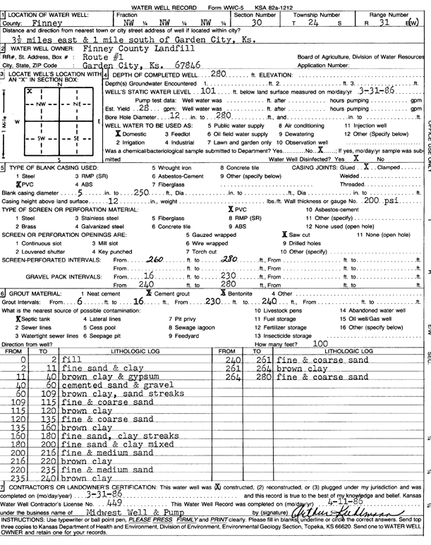
T24S, R31W, Sec. 30 NW NW NW |
Finney County Landfill | 280 ft. | 101 ft. | 28 gpm. | Domestic | Constructed | 31-Mar-1986 | Scan | |
|
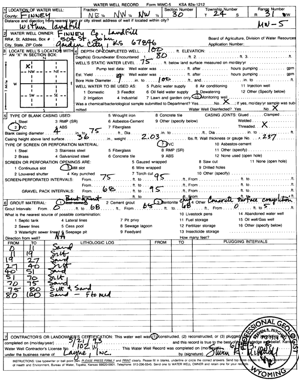
T24S, R31W, Sec. 30 NE NW NW |
Finney County Landfill | 100 ft. | 75 ft. | Monitoring well/observation/piezometer | MW 5 | Constructed | 21-May-1993 | Scan | |
|
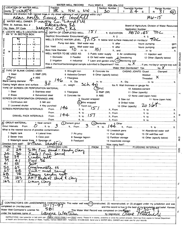
T24S, R31W, Sec. 30 NE NW NW |
Finney County Landfill | 151 ft. | 97.15 ft. | Monitoring well/observation/piezometer | MW 15 | Constructed | 17-Oct-1997 | Scan | |
|
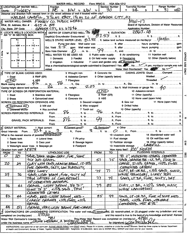
T24S, R31W, Sec. 30 NE NW NW |
Finney County Public Works | 96 ft. | 87.55 ft. | Monitoring well/observation/piezometer | MW 17 | Constructed | 25-Jan-2001 | Scan | |
|
T24S, R31W, Sec. 30 NE NW NW NW |
Finney County Public Works | 129 ft. | Monitoring well/observation/piezometer | MW 17 R | Constructed | 07-Feb-2007 | |||
|
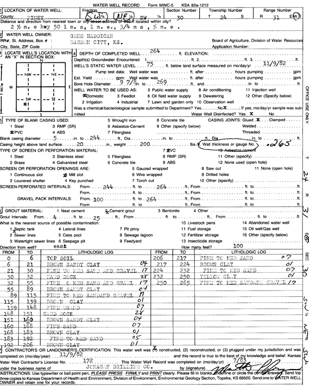
T24S, R31W, Sec. 30 SW NW SW |
Haddican, Gene | 264 ft. | 75 ft. | Domestic | Constructed | 09-Nov-1982 | Scan | ||
|
T24S, R31W, Sec. 30 NW NW NW SW |
Pietz, Chad | 276 ft. | 122 ft. | Domestic, Livestock | Constructed | 04-Feb-2015 | |||
|
T24S, R31W, Sec. 30 SW NW NW |
West Plains Regional Landfill | 94 ft. | 87 ft. | Monitoring well/observation/piezometer | MW 21A | Constructed | 10-Mar-2005 | ||
|
T24S, R31W, Sec. 30 NE NE NW |
West Plains Regional Landfill | 119 ft. | 109.8 ft. | Monitoring well/observation/piezometer | MW 23 | Constructed | 09-Mar-2005 | ||
|
T24S, R31W, Sec. 30 SE NW NW |
West Plains Regional Landfill | 104 ft. | 93.15 ft. | Monitoring well/observation/piezometer | MW 22 | Constructed | 10-Mar-2005 | ||
|
T24S, R31W, Sec. 30 NW SE NW |
West Plains Regional Landfill | 104 ft. | 97 ft. | Monitoring well/observation/piezometer | MW 20 | Constructed | 10-Mar-2005 | ||
|
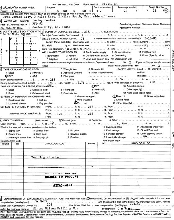
T24S, R31W, Sec. 31 NW NW |
Foulks, Harley | 218 ft. | 78 ft. | Domestic | Constructed | 18-Aug-1983 | Scan | ||
|
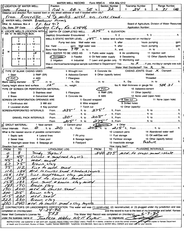
T24S, R31W, Sec. 32 NW NE SE |
Brookover Farms | 275 ft. | 145 ft. | Domestic | Constructed | 24-Apr-1992 | Scan | ||
|
T24S, R31W, Sec. 32 SE NW |
Finney County | 94 ft. | (unstated)/abandoned | Plugged | 26-Aug-2007 | ||||
| View page: < Prev || 31 || 32 || 33 || 34 || 35 || 36 || 37 || 38 || 39 || 40 || Next > | |||||||||