Select location of well to view details.
Click on column heading to sort.
|
|
|
County: Finney Select location of well to view details. Click on column heading to sort. |
|
|
|
| View page: < Prev || 91 || 92 || 93 || 94 || 95 || 96 || 97 || 98 || 99 || 100 || Next > | |||||||||
| T-R-S | Owner | Well Depth Ascend. Desc. |
Static Water Level Ascend. Desc. |
Est. Yield Ascend. Desc. |
Well Use | Other ID | Action Taken | Completion Date Ascend. Desc. |
Scan? |
|
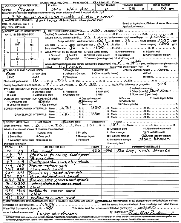
T25S, R34W, Sec. 6 SW NE NW |
Sunflower Electric Power Corp. | 430 ft. | 75 ft. | Industrial | Constructed | 05-Jan-1980 | Scan | ||
|
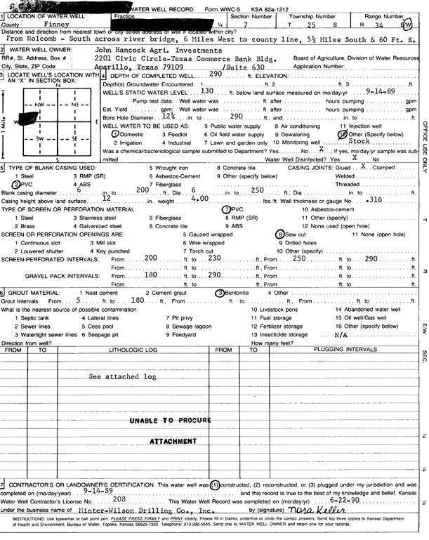
T25S, R34W, Sec. 7 SW SW NW |
John Hancock Agri. Investments | 290 ft. | 130 ft. | Domestic, Livestock | Constructed | 14-Sep-1989 | Scan | ||
|
T25S, R34W, Sec. 7 SE |
Wheatland Electric Cooperative | 361 ft. | 260 ft. | Irrigation | Plugged | 25-Jan-2011 | |||
|
T25S, R34W, Sec. 7 NE NE SE |
Wheatland Electric Cooperative | 420 ft. | 244 ft. | Test hole/well | Hartland Farms Cir F10 | Constructed | 13-Jan-2011 | ||
|
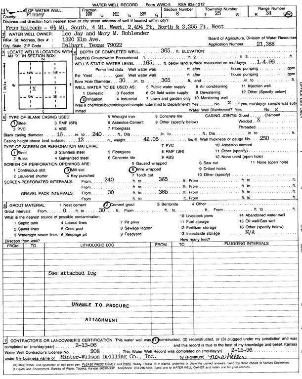
T25S, R34W, Sec. 8 NW NE SW |
Bohlender, Leo Jay and Mary M. | 365 ft. | 165 ft. | Irrigation | Constructed | 13-Feb-1996 | Scan | ||
|
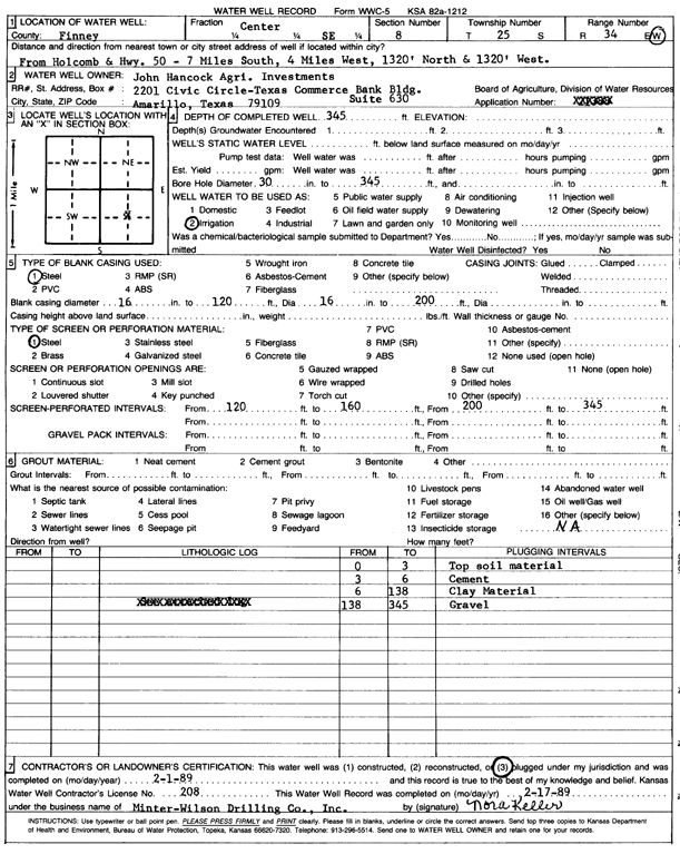
T25S, R34W, Sec. 8 C SE |
John Hancock Agri. Investments | 345 ft. | Irrigation | Plugged | 01-Feb-1989 | Scan | |||
|
T25S, R34W, Sec. 8 C SE |
John Hancock Agri. Investments | 365 ft. | 138 ft. | Irrigation | Constructed | 30-Nov-1988 | Scan | ||
|
T25S, R34W, Sec. 8 SE |
Wheatland Electric Cooperative | 344 ft. | 250 ft. | Irrigation | Plugged | 06-Aug-2012 | |||
|
T25S, R34W, Sec. 8 SE SE SE |
Wheatland Electric Cooperative | 400 ft. | 252 ft. | Irrigation | Constructed | 08-Aug-2012 | |||
|
T25S, R34W, Sec. 8 NW NW NW |
Wheatland Electric Cooperative | 415 ft. | 269 ft. | Irrigation | Constructed | 22-Jul-2014 | |||
|
T25S, R34W, Sec. 9 SW SW SE SW |
Tri-State Generation | 417 ft. | 264 ft. | 406 gpm. | Irrigation | Constructed | 05-May-2015 |
KOLAR |
|
|
T25S, R34W, Sec. 9 SW SW SE SE |
Tri-State Generation | 417 ft. | 274 ft. | 398 gpm. | Irrigation | Constructed | 01-May-2015 |
KOLAR |
|
|
T25S, R34W, Sec. 9 NE NE NE |
Tri-State Generation and Transmission | 440 ft. | 224.5 ft. | Irrigation | Constructed | 24-Apr-2009 | |||
|
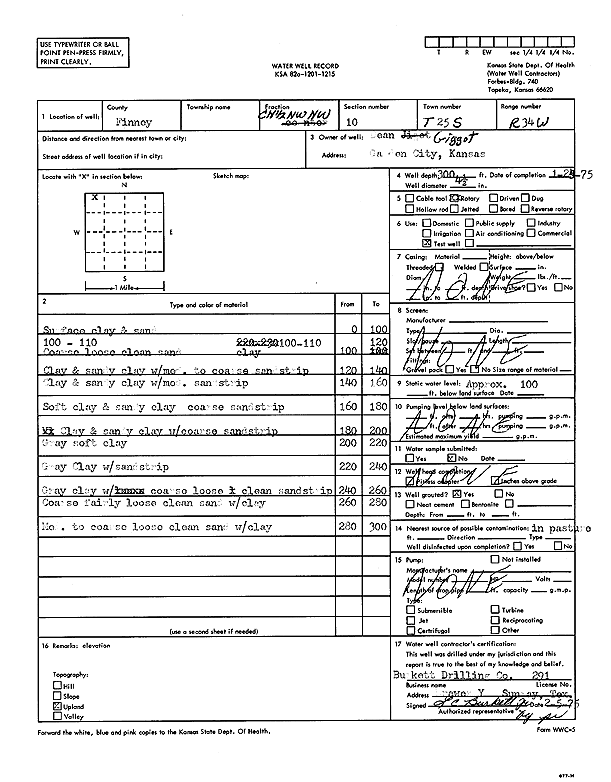
T25S, R34W, Sec. 10 C N2 NW NW |
Gigot, Dean | 300 ft. | 100 ft. | Test hole/well | Constructed | 25-Jan-1975 | Scan | ||
|
T25S, R34W, Sec. 10 NE NE SW |
Tri-State Generation and Transmission | 410 ft. | 225 ft. | Irrigation | Constructed | 22-May-2008 | |||
|
T25S, R34W, Sec. 10 SE SW NW NE |
Tri-State Generation and Transmission | 706 ft. | 286 ft. | 617 gpm. | Irrigation | Constructed | 27-Apr-2017 |
KOLAR |
|
|
T25S, R34W, Sec. 10 SE |
440 ft. | Irrigation | Well 9 | Reconstructed | 23-Jul-1974 | ||||
|
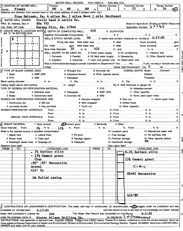
T25S, R34W, Sec. 11 NW NW NW |
Circle Land and Cattle Co. | 430 ft. | 95 ft. | 1500 gpm. | Irrigation | Constructed | 19-Feb-1985 | Scan | |
|
T25S, R34W, Sec. 11 NW NW NW |
Circle Land and Cattle Co. | 416 ft. | 88 ft. | Irrigation | Plugged | 27-Mar-1985 | Scan | ||
|
T25S, R34W, Sec. 11 SE SW SE SE |
Harder, Heinrich | 454 ft. | 280 ft. | 50 gpm. | Domestic | Constructed | 14-Oct-2020 |
KOLAR |
|
|
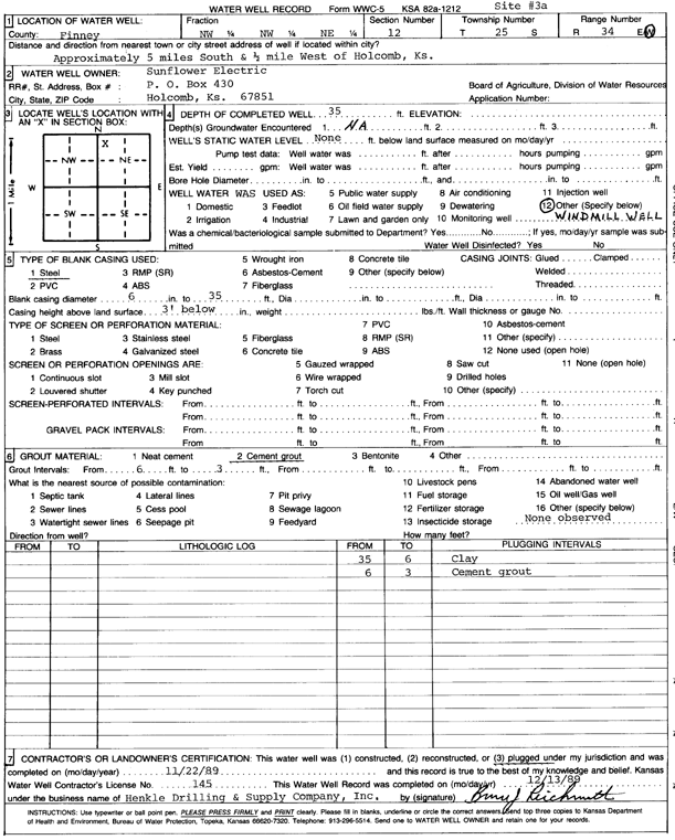
T25S, R34W, Sec. 12 NW NW NE |
Sunflower Electric Power Corp. | 35 ft. | Domestic, Livestock | Site 3a | Plugged | 22-Nov-1989 | Scan | ||
|
T25S, R34W, Sec. 12 NW NW NE |
Sunflower Electric Power Corp. | 300 ft. | 152 ft. | 50 gpm. | Domestic | Constructed | 09-Oct-1996 | ||
|
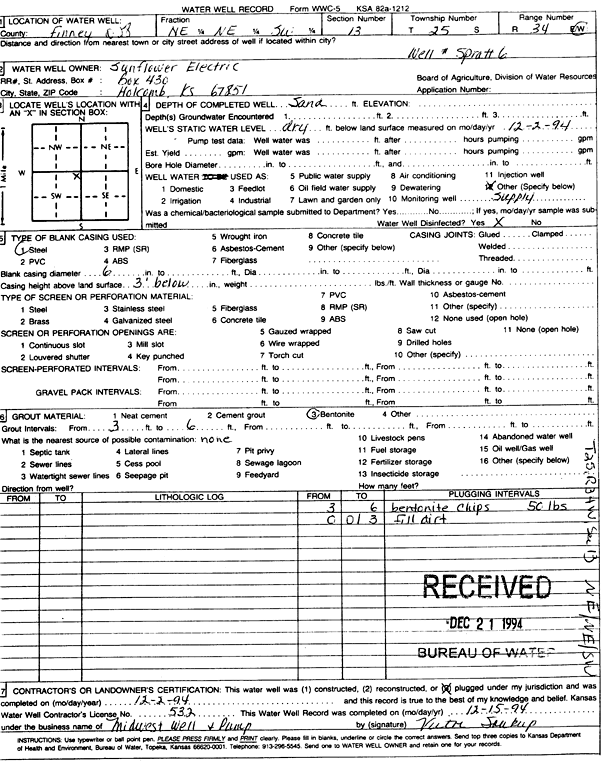
T25S, R34W, Sec. 12 NE NE SW |
Sunflower Electric Power Corp. | Oil Field Water Supply | Spratt 6 | Plugged | 02-Dec-1994 | Scan | |||
|
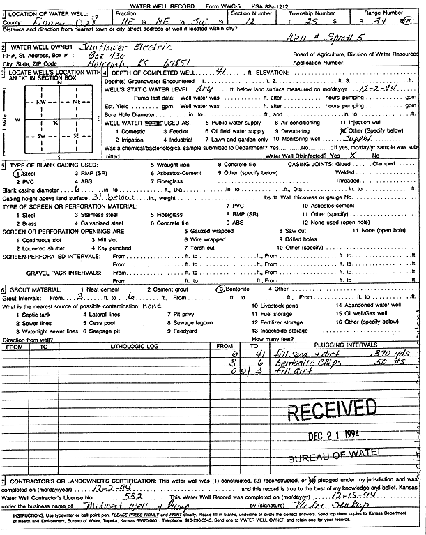
T25S, R34W, Sec. 12 NE NE SW |
Sunflower Electric Power Corp. | 41 ft. | Oil Field Water Supply | Spratt 5 | Plugged | 02-Dec-1994 | Scan | ||
|
T25S, R34W, Sec. 13 NW |
Reeve, M. P. | 508 ft. | 143 ft. | 1295 gpm. | Irrigation | Constructed | 30-Sep-1978 | Scan | |
|
T25S, R34W, Sec. 13 SE NW NW |
Sunflower Electric Power Corp. | 437 ft. | 201 ft. | Monitoring well/observation/piezometer | OBS 1 | Constructed | 04-Mar-2005 | ||
|
T25S, R34W, Sec. 13 SE SW NE |
Sunflower Electric Power Corp. | 445 ft. | 167 ft. | Monitoring well/observation/piezometer | MW 7-00 | Constructed | 15-Dec-2000 | Scan | |
|
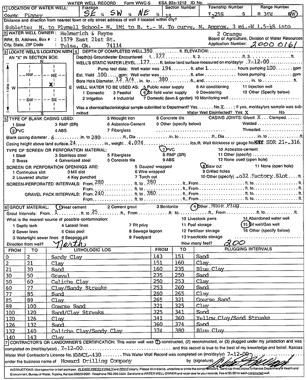
T25S, R34W, Sec. 15 SE SW NE |
Helmerich and Payne Inc. | 380 ft. | 177 ft. | Oil Field Water Supply | Orange 2 | Constructed | 12-Jul-2000 | Scan | |
|
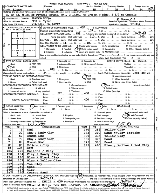
T25S, R34W, Sec. 15 SW SW SE |
Hummon Corp. | 400 ft. | 158 ft. | 100 gpm. | Oil Field Water Supply | O.J. Brown 1 | Constructed | 23-Sep-1997 | Scan |
|
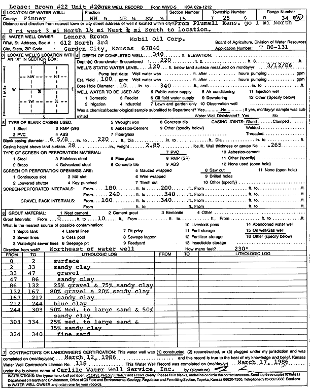
T25S, R34W, Sec. 15 NW NE SW |
Mobil Oil Corp./Lenora Brown | 340 ft. | 120 ft. | 100 gpm. | Oil Field Water Supply | Brown 22, Unit 23 | Constructed | 12-Mar-1986 | Scan |
|
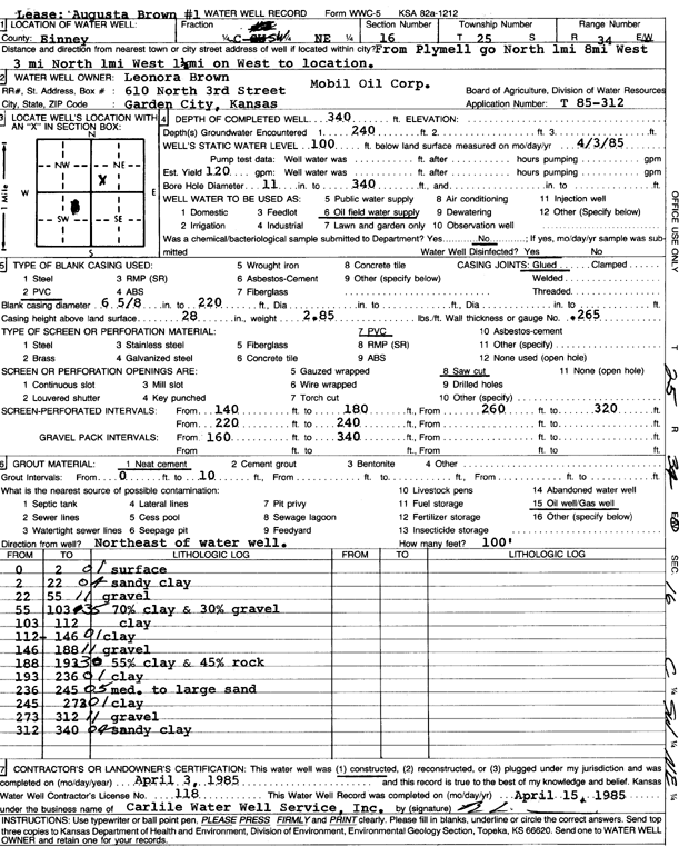
T25S, R34W, Sec. 16 C SW NE |
Mobil Oil Corp./Lenora Brown | 340 ft. | 100 ft. | 120 gpm. | Oil Field Water Supply | Augusta Brown 1 | Constructed | 03-Apr-1985 | Scan |
|
T25S, R34W, Sec. 16 NW NW NE |
Sweetman Drilling Co. | 266 ft. | 125 ft. | 100 gpm. | Oil Field Water Supply | Constructed | 04-Feb-1988 | Scan | |
|
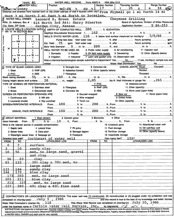
T25S, R34W, Sec. 17 C SW SW |
Cheyenne Drilling/Leonard S. Brown Estate | 280 ft. | 118 ft. | 75 gpm. | Oil Field Water Supply | Brown 1 | Constructed | 05-Jul-1986 | Scan |
|
T25S, R34W, Sec. 18 NW SW SE |
PAK Partnership | 390 ft. | 182 ft. | Irrigation | Constructed | 12-Jan-2006 | |||
|
T25S, R34W, Sec. 18 SE NE NW |
Wheatland Electric Cooperative | 450 ft. | 230.5 ft. | Irrigation | Constructed | 27-Apr-2009 | |||
|
T25S, R34W, Sec. 18 SE SW SW |
Wheatland Electric Cooperative | 400 ft. | 294 ft. | Irrigation | Test 1 | Constructed | 07-Jun-2013 | ||
|
T25S, R34W, Sec. 18 SW |
Wheatland Electric Cooperative | 380 ft. | 260 ft. | Irrigation | Plugged | 06-Jun-2013 | |||
|
T25S, R34W, Sec. 18 NE |
Wheatland Electric Cooperative | 355 ft. | 286 ft. | Irrigation | Plugged | 22-Mar-2017 | |||
|
T25S, R34W, Sec. 18 S2 S2 N2 NE |
Wheatland Electric Cooperative | 482 ft. | 286 ft. | 508 gpm. | Irrigation | Constructed | 09-Mar-2017 |
KOLAR |
|
|
T25S, R34W, Sec. 18 NE SW SE |
Yost Yards | 605 ft. | 311 ft. | 800 gpm. | Irrigation | Constructed | 05-Jun-2025 |
KOLAR |
|
|
T25S, R34W, Sec. 19 NW |
Campbell, Jack | 354 ft. | 65 ft. | 1100 gpm. | Irrigation | Constructed | 10-Apr-1975 | Scan | |
|
T25S, R34W, Sec. 19 SW |
Campbell, Jack | 350 ft. | 65 ft. | 1200 gpm. | Irrigation | Constructed | 12-Apr-1975 | Scan | |
|
T25S, R34W, Sec. 19 NE |
Campbell, Jack | 365 ft. | 65 ft. | 1200 gpm. | Irrigation | Constructed | 10-Apr-1975 | Scan | |
|
T25S, R34W, Sec. 19 SE |
Campbell, Jack | 352 ft. | 65 ft. | 1200 gpm. | Irrigation | Constructed | 11-Apr-1975 | Scan | |
|
T25S, R34W, Sec. 19 SW SE SW |
Southwest Ag | 610 ft. | 314 ft. | 450 gpm. | Irrigation | Constructed | 08-Jun-2023 |
KOLAR |
|
|
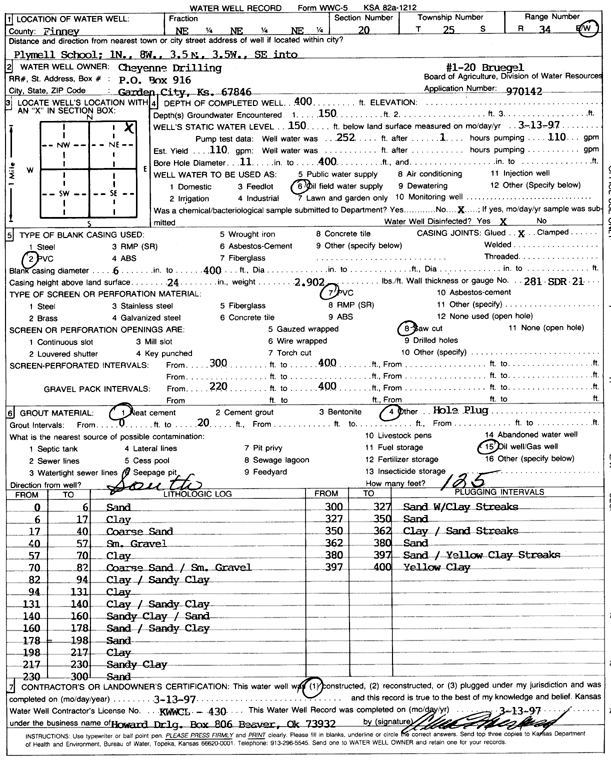
T25S, R34W, Sec. 20 NE NE NE |
Cheyenne Drilling | 400 ft. | 150 ft. | 110 gpm. | Oil Field Water Supply | Bruegel 1-20 | Constructed | 13-Mar-1997 | Scan |
|
T25S, R34W, Sec. 21 NW NW NE |
Sweetman Drilling Co. | 232 ft. | 117 ft. | Oil Field Water Supply | Constructed | 11-Nov-1987 | Scan | ||
|
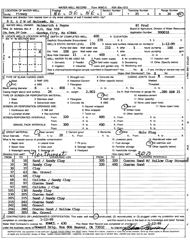
T25S, R34W, Sec. 22 NE SE NE |
Helmerich and Payne Inc. | 400 ft. | 170 ft. | 100 gpm. | Oil Field Water Supply | Fred 2 | Constructed | 12-Jan-1999 | Scan |
|
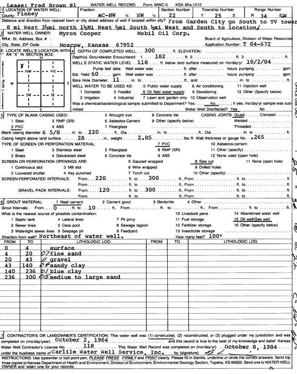
T25S, R34W, Sec. 22 C NW NW |
Mobil Oil Corp./Myron Cooper | 300 ft. | 118 ft. | 60 gpm. | Oil Field Water Supply | Fred Brown 1 | Constructed | 02-Oct-1984 | Scan |
|
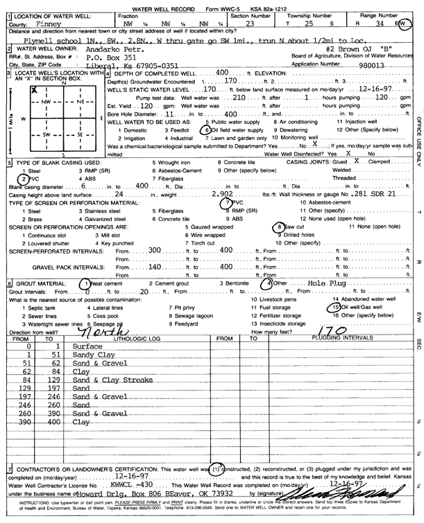
T25S, R34W, Sec. 23 NW NW NW |
Anadarko Petroleum Corp. | 400 ft. | 170 ft. | 120 gpm. | Oil Field Water Supply | O.J. Brown B-2 | Constructed | 16-Dec-1997 | Scan |
| View page: < Prev || 91 || 92 || 93 || 94 || 95 || 96 || 97 || 98 || 99 || 100 || Next > | |||||||||