Select location of well to view details.
Click on column heading to sort.
|
|
|
County: Thomas Select location of well to view details. Click on column heading to sort. |
|
|
|
| View page: < Prev || 21 || 22 || 23 || 24 || 25 || 26 || 27 || 28 || 29 || 30 || Next > | |||||||||
| T-R-S | Owner | Well Depth Ascend. Desc. |
Static Water Level Ascend. Desc. |
Est. Yield Ascend. Desc. |
Well Use | Other ID | Action Taken | Completion Date Ascend. Desc. |
Scan? |
|
T8S, R33W, Sec. 5 NW NW NE NW |
U.S. EPA Region 7 | 142 ft. | Monitoring well/observation/piezometer | MW 13 S | Plugged | 25-Feb-2014 |
KOLAR |
||
|
T8S, R33W, Sec. 5 SW SW NE NW |
U.S. EPA Region 7 | 156 ft. | 147 ft. | Monitoring well/observation/piezometer | MW 16 S | Plugged | 18-Feb-2014 |
KOLAR |
|
|
T8S, R33W, Sec. 5 SW SW NE NW |
U.S. EPA Region 7 | 262 ft. | 147 ft. | Monitoring well/observation/piezometer | MW 16 D | Plugged | 25-Feb-2014 |
KOLAR |
|
|
T8S, R33W, Sec. 5 SE NW NW NE |
U.S. EPA Region 7 | 263 ft. | 143.6 ft. | Monitoring well/observation/piezometer | MW 12-D | Plugged | 10-Apr-2013 |
KOLAR |
|
|
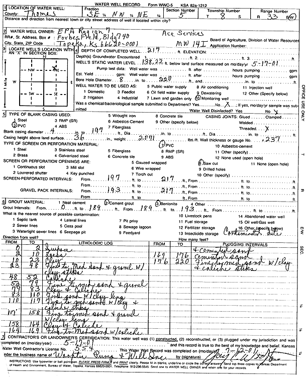
T8S, R33W, Sec. 5 SE NW NE |
U.S. EPA Region 7, Ace Services Site | 217 ft. | 138.2 ft. | Monitoring well/observation/piezometer | MW 14 I | Constructed | 17-May-2001 | Scan | |
|
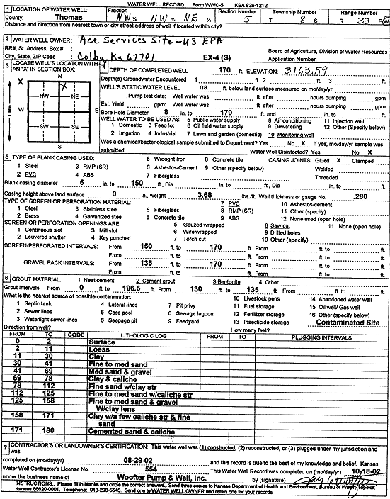
T8S, R33W, Sec. 5 NW NW NE |
U.S. EPA Region 7, Ace Services Site | 170 ft. | Monitoring well/observation/piezometer | EX 4 S | Constructed | 29-Aug-2002 | Scan | ||
|
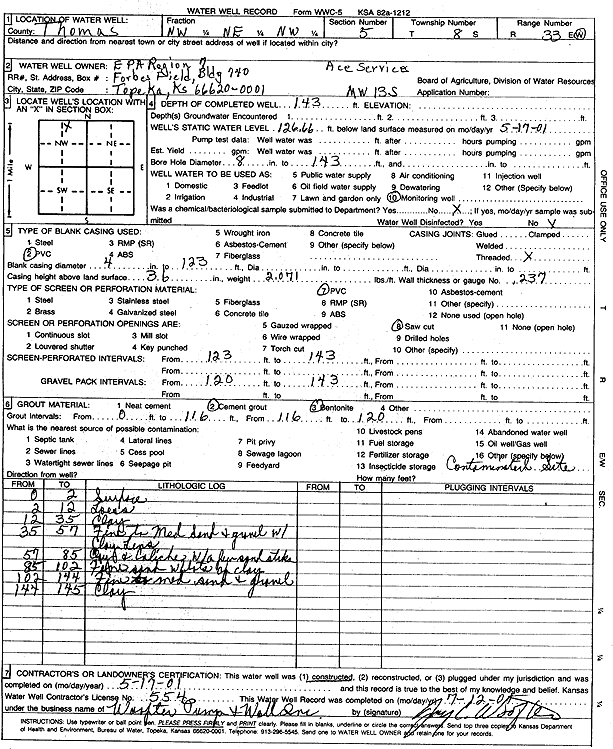
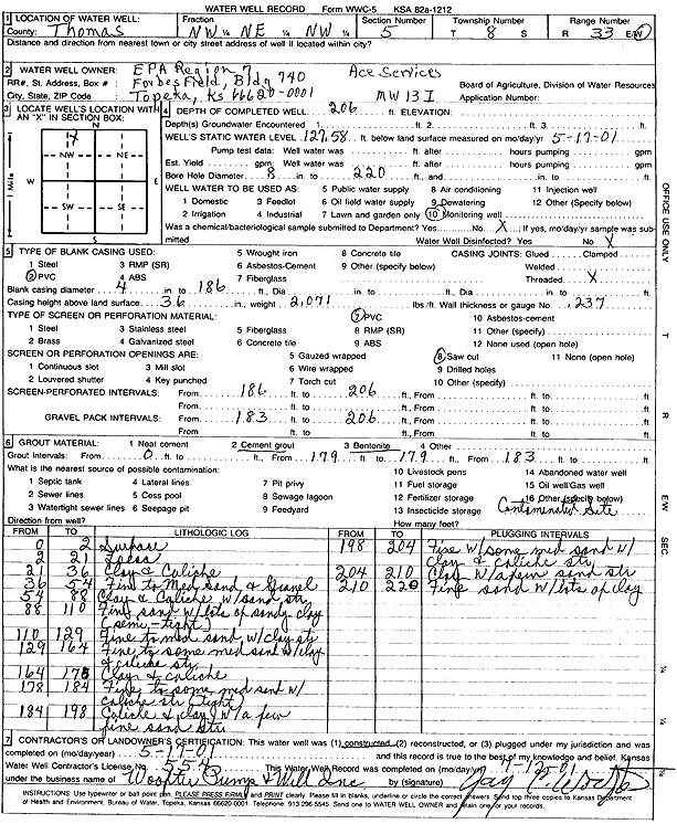
T8S, R33W, Sec. 5 NW NE NW |
U.S. EPA Region 7, Ace Services Site | 143 ft. | 126.66 ft. | Monitoring well/observation/piezometer | MW 13 S | Constructed | 17-May-2001 | Scan | |
|
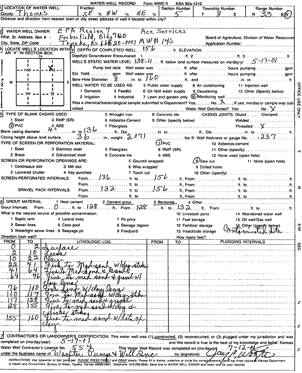
T8S, R33W, Sec. 5 SE NW NE |
U.S. EPA Region 7, Ace Services Site | 156 ft. | 138.1 ft. | Monitoring well/observation/piezometer | MW 14 S | Constructed | 17-May-2001 | Scan | |
|
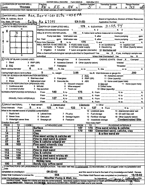
T8S, R33W, Sec. 5 NW NE NW |
U.S. EPA Region 7, Ace Services Site | 175 ft. | Monitoring well/observation/piezometer | EX 3 S | Constructed | 22-Aug-2002 | Scan | ||
|
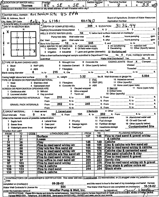
T8S, R33W, Sec. 5 NE SE SE |
U.S. EPA Region 7, Ace Services Site | 245 ft. | Monitoring well/observation/piezometer | EX 1 D | Constructed | 26-Aug-2002 | Scan | ||
|
T8S, R33W, Sec. 5 NW NE NW |
U.S. EPA Region 7, Ace Services Site | 206 ft. | 127.58 ft. | Monitoring well/observation/piezometer | MW 13 I | Constructed | 17-May-2001 | Scan | |
|
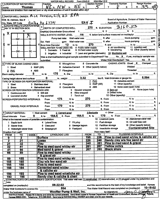
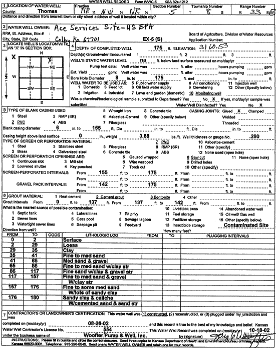
T8S, R33W, Sec. 5 NE NW NE |
U.S. EPA Region 7, Ace Services Site | 270 ft. | Monitoring well/observation/piezometer | EX 5 I | Constructed | 22-Aug-2002 | Scan | ||
|
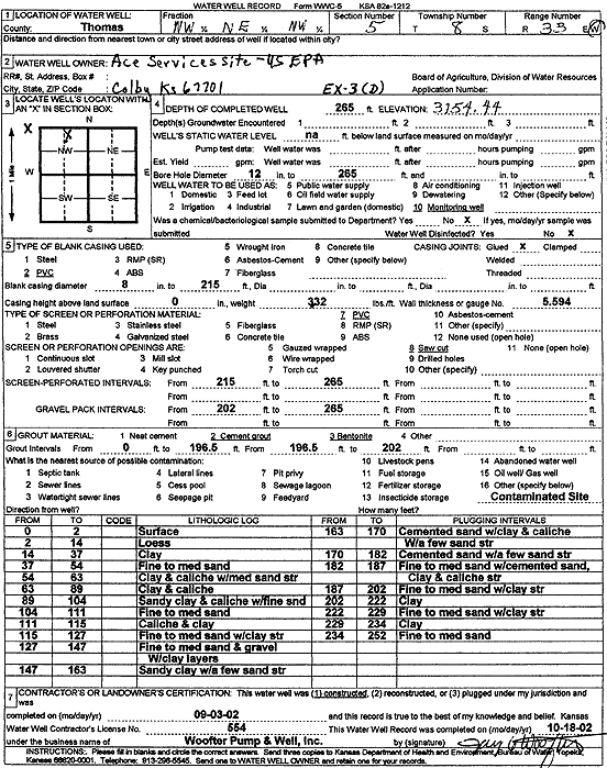
T8S, R33W, Sec. 5 NW NE NW |
U.S. EPA Region 7, Ace Services Site | 265 ft. | Monitoring well/observation/piezometer | EX 3 D | Constructed | 03-Sep-2002 | Scan | ||
|
T8S, R33W, Sec. 5 NE NW NE |
U.S. EPA Region 7, Ace Services Site | 175 ft. | Monitoring well/observation/piezometer | EX 5 S | Constructed | 26-Aug-2002 | Scan | ||
|
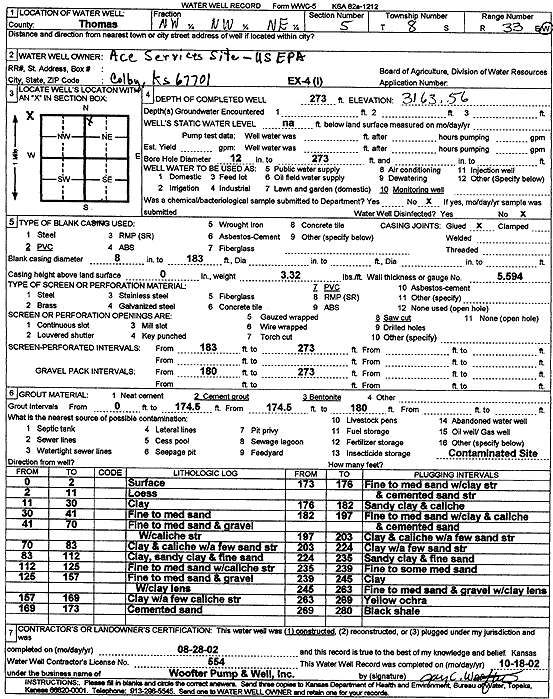
T8S, R33W, Sec. 5 NW NW NE |
U.S. EPA Region 7, Ace Services Site | 273 ft. | Monitoring well/observation/piezometer | EX 4 I | Constructed | 28-Aug-2002 | Scan | ||
|
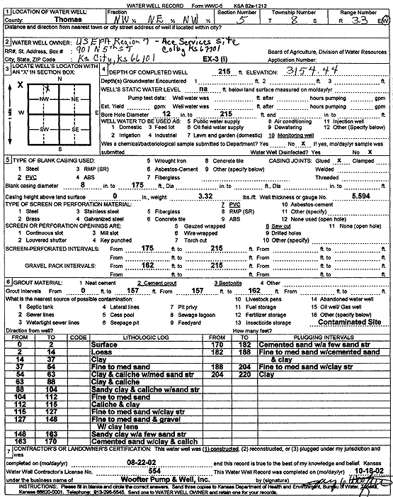
T8S, R33W, Sec. 5 NW NE NW |
U.S. EPA Region 7, Ace Services Site | 215 ft. | Monitoring well/observation/piezometer | EX 3 I | Constructed | 22-Aug-2002 | Scan | ||
|
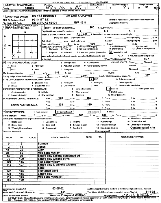
T8S, R33W, Sec. 5 NW NW NE |
U.S. EPA Region 7, Black and Veatch | 160 ft. | 136.6 ft. | Monitoring well/observation/piezometer | MW 15 S | Constructed | 05-Mar-2002 | Scan | |
|
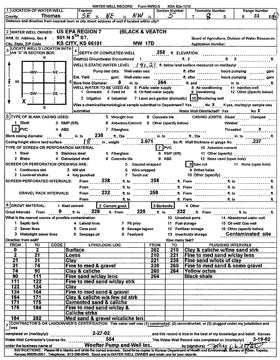
T8S, R33W, Sec. 5 SE NE NW |
U.S. EPA Region 7, Black and Veatch | 258 ft. | 141.21 ft. | Monitoring well/observation/piezometer | MW 17 D | Constructed | 27-Feb-2002 | Scan | |
|
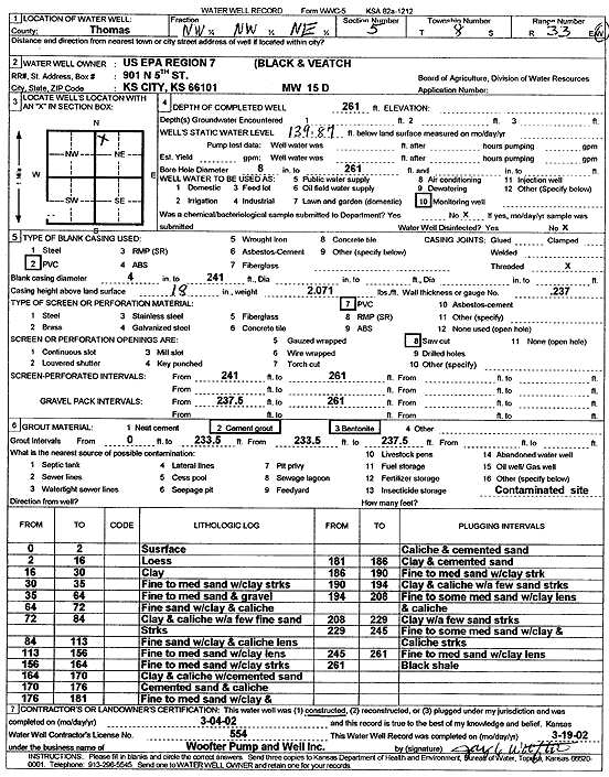
T8S, R33W, Sec. 5 NW NW NE |
U.S. EPA Region 7, Black and Veatch | 261 ft. | 139.87 ft. | Monitoring well/observation/piezometer | MW 15 D | Constructed | 04-Mar-2002 | Scan | |
|
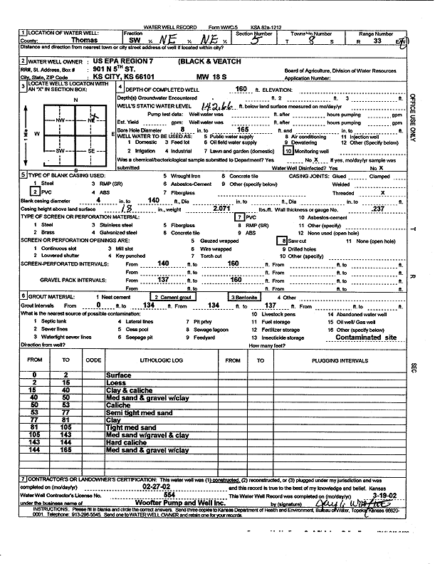
T8S, R33W, Sec. 5 SW NE NE |
U.S. EPA Region 7, Black and Veatch | 160 ft. | 142.66 ft. | Monitoring well/observation/piezometer | MW 18 S | Constructed | 27-Feb-2002 | Scan | |
|
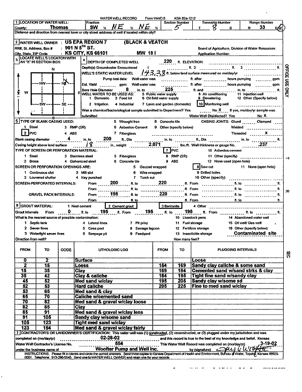
T8S, R33W, Sec. 5 SW NE NW |
U.S. EPA Region 7, Black and Veatch | 259 ft. | 135.08 ft. | Monitoring well/observation/piezometer | MW 16 D | Constructed | 04-Mar-2002 | Scan | |
|
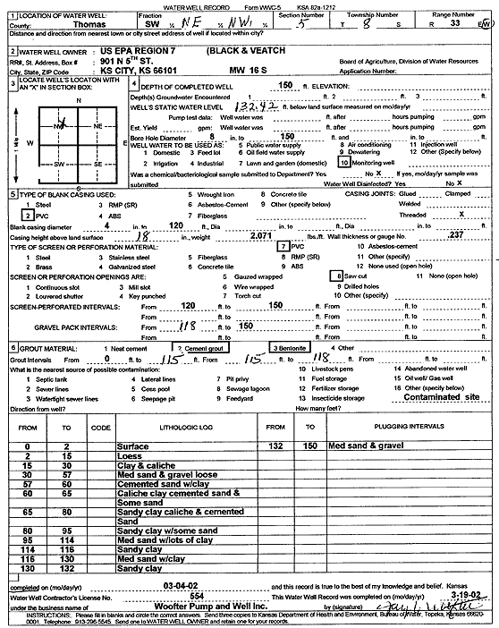
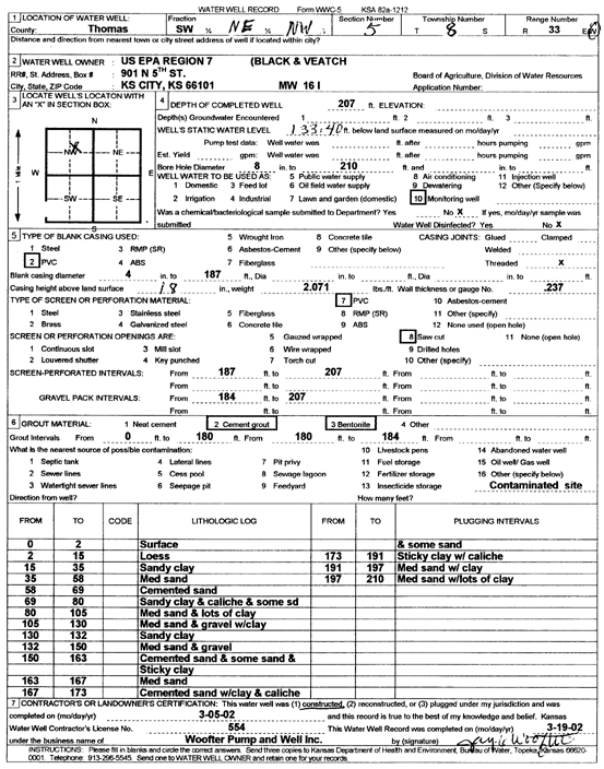
T8S, R33W, Sec. 5 SW NE NW |
U.S. EPA Region 7, Black and Veatch | 150 ft. | 132.4 ft. | Monitoring well/observation/piezometer | MW 16 S | Constructed | 04-Mar-2002 | Scan | |
|
T8S, R33W, Sec. 5 SW NE NE |
U.S. EPA Region 7, Black and Veatch | 220 ft. | 143.38 ft. | Monitoring well/observation/piezometer | MW 18 I | Constructed | 28-Feb-2002 | Scan | |
|
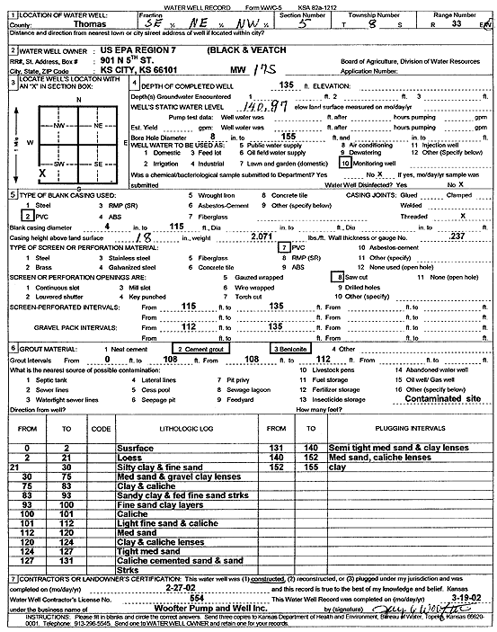
T8S, R33W, Sec. 5 SE NE NW |
U.S. EPA Region 7, Black and Veatch | 135 ft. | 140.97 ft. | Monitoring well/observation/piezometer | MW 17 S | Constructed | 27-Feb-2002 | Scan | |
|
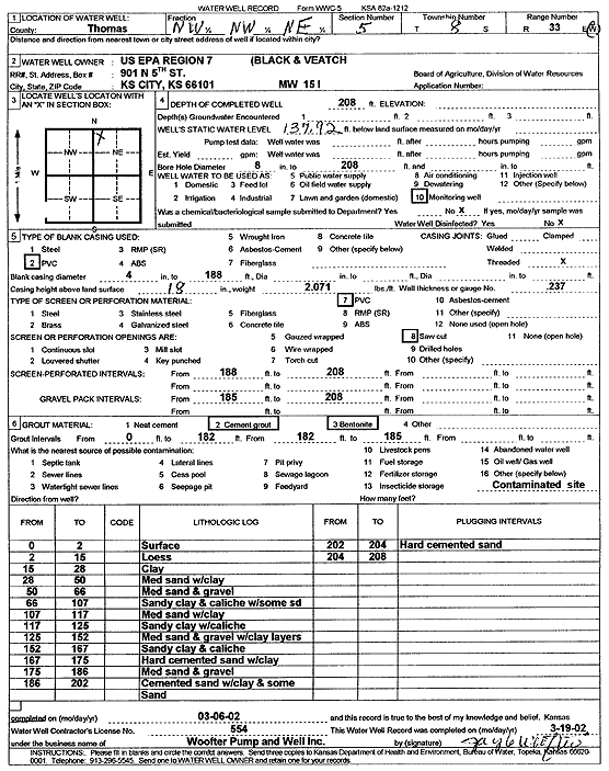
T8S, R33W, Sec. 5 NW NW NE |
U.S. EPA Region 7, Black and Veatch | 208 ft. | 137.92 ft. | Monitoring well/observation/piezometer | MW 15 I | Constructed | 06-Mar-2002 | Scan | |
|
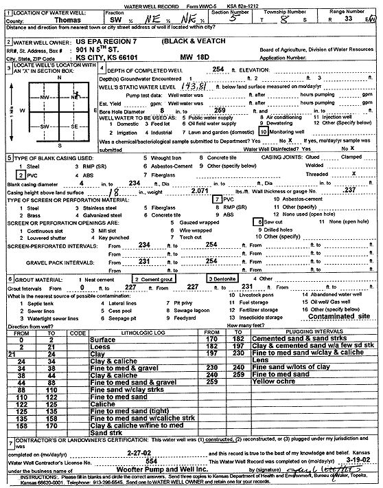
T8S, R33W, Sec. 5 SW NE NE |
U.S. EPA Region 7, Black and Veatch | 254 ft. | 143.81 ft. | Monitoring well/observation/piezometer | MW 18 D | Constructed | 27-Feb-2002 | Scan | |
|
T8S, R33W, Sec. 5 SW NE NW |
U.S. EPA Region 7, Black and Veatch | 207 ft. | 133.4 ft. | Monitoring well/observation/piezometer | MW 16 I | Constructed | 05-Mar-2002 | Scan | |
|
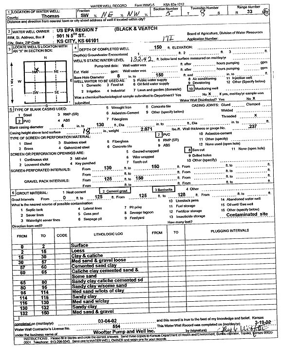
T8S, R33W, Sec. 5 SW NE NW |
U.S. EPA Region 7, Black and Veatch | 150 ft. | 132.42 ft. | Monitoring well/observation/piezometer | MW 17 I | Constructed | 04-Mar-2002 | Scan | |
|
T8S, R33W, Sec. 5 NE NE NE |
Wagoner and Sons | Domestic | Plugged | 14-Jan-1987 | |||||
|
T8S, R33W, Sec. 6 NE |
Ace Services Inc | 224 ft. | 77.5 ft. | Dewatering | Constructed | 10-Oct-1980 | |||
|
T8S, R33W, Sec. 6 NE SW NE |
Bell Ditching | 268 ft. | 132 ft. | 13 gpm. | Domestic | Constructed | 07-Jun-1975 | ||
|
T8S, R33W, Sec. 6 NW NW NW |
City of Colby | 126.93 ft. | 123.43 ft. | Monitoring well/observation/piezometer | MW 3 | Plugged | 06-Sep-2005 | ||
|
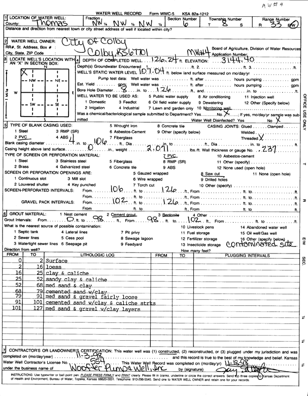
T8S, R33W, Sec. 6 NW NW NW |
City of Colby | 126.24 ft. | 107.04 ft. | Monitoring well/observation/piezometer | MW 4 | Constructed | 03-Nov-1998 | Scan | |
|
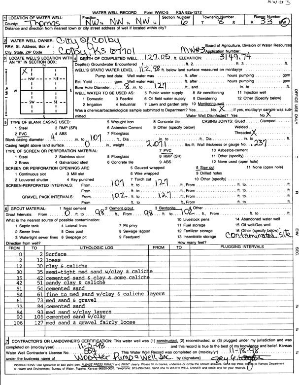
T8S, R33W, Sec. 6 NW NW NW |
City of Colby | 127.05 ft. | 112.98 ft. | Monitoring well/observation/piezometer | MW 3 | Constructed | 03-Nov-1998 | Scan | |
|
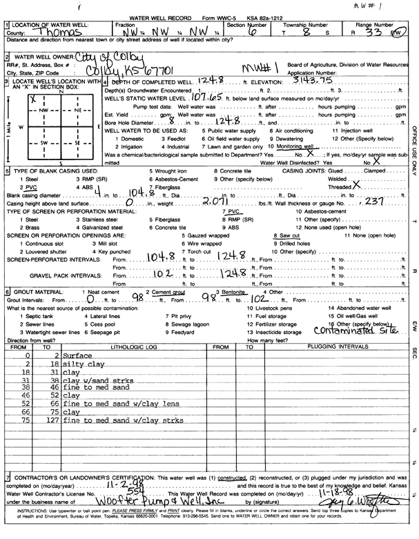
T8S, R33W, Sec. 6 NW NW NW |
City of Colby | 124.8 ft. | 107.65 ft. | Monitoring well/observation/piezometer | MW 1 | Constructed | 02-Nov-1998 | Scan | |
|
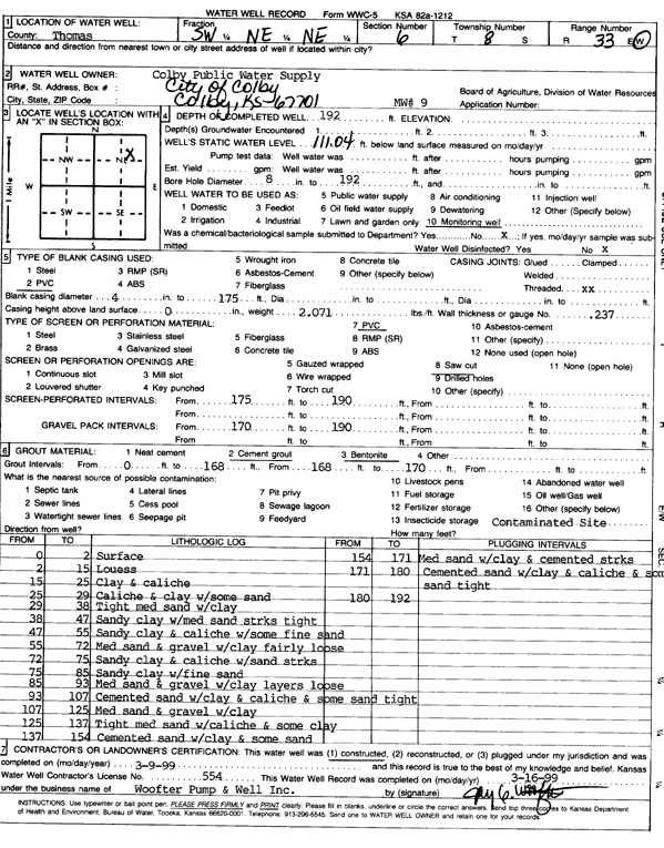
T8S, R33W, Sec. 6 SW NE NE |
City of Colby | 192 ft. | 111.04 ft. | Monitoring well/observation/piezometer | MW 9 | Constructed | 09-Mar-1999 | Scan | |
|
T8S, R33W, Sec. 6 SW NE NE |
City of Colby | 193.5 ft. | 120 ft. | Monitoring well/observation/piezometer | MW 8 | Plugged | 06-Sep-2005 | ||
|
T8S, R33W, Sec. 6 NE SW NE |
City of Colby | 127.3 ft. | 123.8 ft. | Monitoring well/observation/piezometer | MW 5 | Plugged | 06-Sep-2005 | ||
|
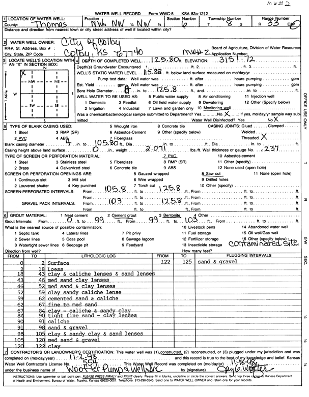
T8S, R33W, Sec. 6 NW NW NW |
City of Colby | 125.75 ft. | 122.09 ft. | Monitoring well/observation/piezometer | MW 2 | Plugged | 06-Sep-2005 | ||
|
T8S, R33W, Sec. 6 NW NW NW |
City of Colby | 126 ft. | Monitoring well/observation/piezometer | MW 4 | Plugged | 06-Sep-2005 | |||
|
T8S, R33W, Sec. 6 NW NW NW |
City of Colby | 126.4 ft. | 120 ft. | Monitoring well/observation/piezometer | MW 1 | Plugged | 06-Sep-2005 | ||
|
T8S, R33W, Sec. 6 NW NW NW |
City of Colby | 125.8 ft. | 115.8 ft. | Monitoring well/observation/piezometer | MW 2 | Constructed | 02-Nov-1998 | Scan | |
|
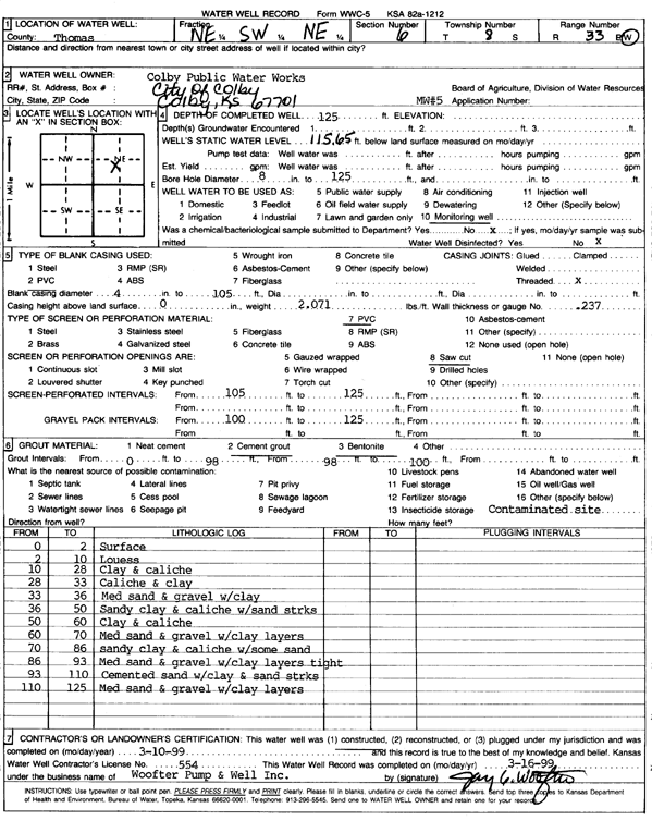
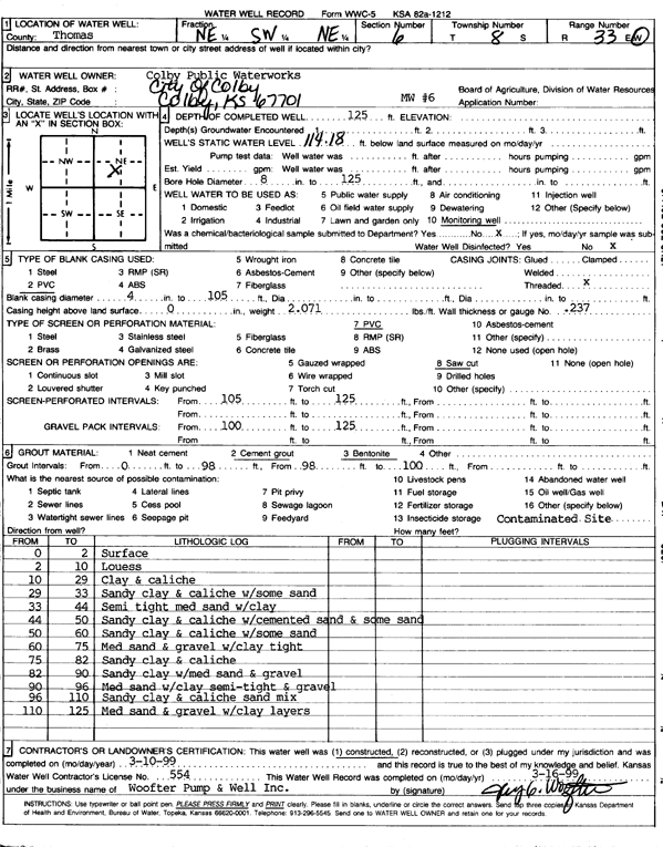
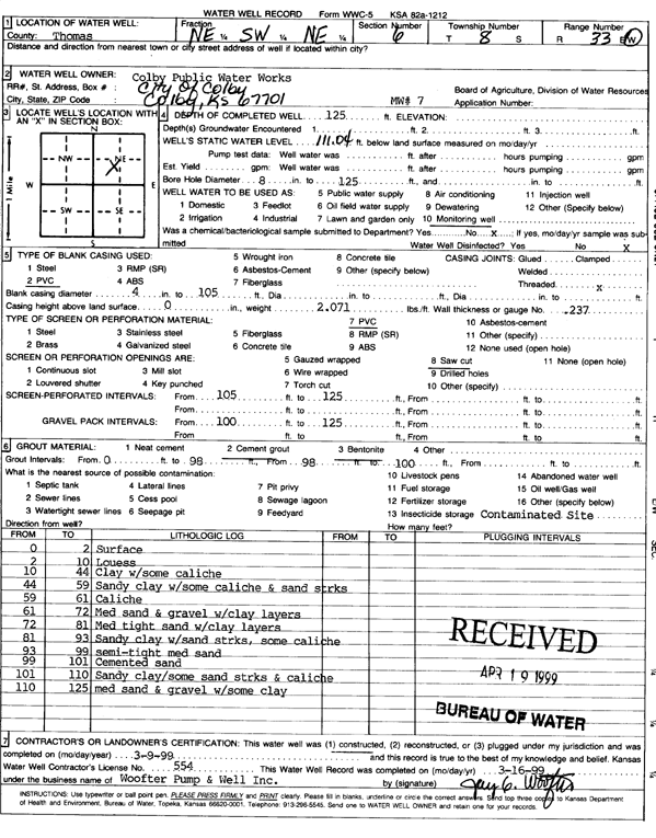
T8S, R33W, Sec. 6 NE SW NE |
City of Colby - Public Water Works | 125 ft. | 115.6 ft. | Monitoring well/observation/piezometer | Constructed | 10-Mar-1999 | Scan | ||
|
T8S, R33W, Sec. 6 NE SW NE |
City of Colby - Public Water Works | 125 ft. | 114.18 ft. | Monitoring well/observation/piezometer | MW 6 | Constructed | 10-Mar-1999 | Scan | |
|
T8S, R33W, Sec. 6 NE SW NE |
City of Colby - Public Water Works | 125 ft. | 111.04 ft. | Monitoring well/observation/piezometer | MW 7 | Constructed | 09-Mar-1999 | Scan | |
|
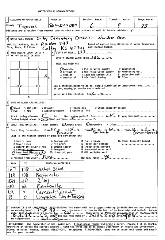
T8S, R33W, Sec. 6 SE SE NE |
Colby Cemetary District One | 127 ft. | 126 ft. | Domestic | Plugged | 30-Jul-1998 | Scan | ||
|
T8S, R33W, Sec. 6 NE SE SE NW |
Deines, E. Jay | 147.7 ft. | 137.18 ft. | Monitoring well/observation/piezometer | MW 7 | Plugged | 18-Sep-2020 |
KOLAR |
|
|
T8S, R33W, Sec. 6 SW SW SW NE |
Deines, E. Jay | 157.3 ft. | 147.47 ft. | Monitoring well/observation/piezometer | MW 6 | Plugged | 18-Sep-2020 |
KOLAR |
|
|
T8S, R33W, Sec. 6 SE SE SE NW |
Deines, E. Jay | 142.81 ft. | 138.85 ft. | Monitoring well/observation/piezometer | MW 2 | Plugged | 18-Sep-2020 |
KOLAR |
|
|
T8S, R33W, Sec. 6 SE SE SE NW |
Deines, E. Jay | 152.5 ft. | 136.87 ft. | Environmental Remediation, Air Sparge | AS 3 | Constructed | 12-Aug-2016 | ||
| View page: < Prev || 21 || 22 || 23 || 24 || 25 || 26 || 27 || 28 || 29 || 30 || Next > | |||||||||